close
-
Layers w
- Weather Layers
- Pro
- Pro
- Pro
- Pro
- Pro
- Pro
- More Layers
- Pro
- Pro
- Pro
- Pro
-
Upgrade to

3D
Trail Conditions
- Unknown
- Snow Groomed
- Snow Packed
- Snow Covered
- Snow Cover Partial
- Freeze/thaw Cycle
- Icy
- Prevalent Mud
- Wet
- Variable
- Ideal
- Dry
- Very Dry
Trail Flow (Ridden Direction)
Trailforks scans users ridelogs to determine the most popular direction each trail is ridden. A good flowing trail network will have most trails flowing in a single direction according to their intension.
The colour categories are based on what percentage of riders are riding a trail in its intended direction.
The colour categories are based on what percentage of riders are riding a trail in its intended direction.
- > 96%
- > 90%
- > 80%
- > 70%
- > 50%
- < 50%
- bi-directional trail
- no data
Trail Last Ridden
Trailforks scans ridelogs to determine the last time a trail was ridden.
- < 2 days
- < 1 week
- < 2 weeks
- < 1 month
- < 6 months
- > 6 months
Trail Ridden Direction
The intended direction a trail should be ridden.
- Downhill Only
- Downhill Primary
- Both Directions
- Uphill Primary
- Uphill Only
- One Direction
Contribute Details
Colors indicate trail is missing specified detail.
- Description
- Photos
- Description & Photos
- Videos
Trail Popularity ?
Trailforks scans ridelogs to determine which trails are ridden the most in the last 9 months.
Trails are compared with nearby trails in the same city region with a possible 25 colour shades.
Think of this as a heatmap, more rides = more kinetic energy = warmer colors.
- most popular
- popular
- less popular
- not popular
ATV/ORV/OHV Filter
Max Vehicle Width
inches
US Cell Coverage
Legend

Radar Time
Activity Recordings
Trailforks uses anonymized public activity data.
?
Activity Recordings
Trailforks uses anonymized public activity data.
?
Personal Heatmap
▶
Activity Types
all
/
none
▶
Options
2
Date range
month
–
Winter Trails
Warning
A routing network for winter maps does not exist. Selecting trails using the winter trails layer has been disabled.
Missing Trails
Most Popular
Least Popular
Trails are colored based on popularity. The more popular a trail is, the more red. Less popular trails trend towards green.
Jump Magnitude Heatmap
Heatmap of where riders jump on trails. Zoom in to see individual jumps, click circles to view jump details.
BC Backroad Status
![map legend]()
Service Road Atlas is a free to use, community-driven service for viewing and creating reports on the numerous back-country service roads around B.C. and Alberta.

Slope Aspect
Direction the slope faces
Trails Deemphasized
Trails are shown in grey.
Only show trails with no bike usage.
Suggested Layers
Based on selected activity type
Save the current map location and zoom level as your default home location whenever this page is loaded.
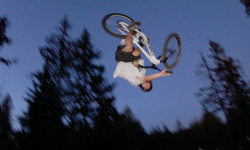
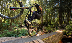
SaveThe Sunshine Coast is becoming recognized as one of the premier mountain biking regions in Canada. With year round riding and a labyrinth of trail systems, it's become a must-ride destination.
AKA: SSC
Activities Click to view
- Mountain Bike
826 trails
- E-Bike
753 trails
- Horse
86 trails
- Hike
895 trails
- Trail Running
867 trails
- Dirtbike/Moto
322 trails
- Observed Trials
260 trails
- ATV/ORV/OHV
139 trails
- Snowshoe
7 trails
- Nordic Ski
14 trails
Stats
- Avg Trail Rating
- Trails (view details)
- 922
- Trails Mountain Bike
- 833
- Trails E-Bike
- 753
- Trails Horse
- 86
- Trails Hike
- 896
- Trails Trail Running
- 867
- Trails Dirtbike/Moto
- 323
- Trails Observed Trials
- 260
- Trails ATV/ORV/OHV
- 139
- Trails Snowmobile
- 1
- Trails Snowshoe
- 7
- Trails Nordic Ski
- 14
- Total Distance
- 638 miles
- Total Descent
- 147,928 ft
- Total Vertical
- 5,514 ft
- Highest Trailhead
- 5,517 ft
- Reports
- 8,166
- Photos
- 3,541
- Ridden Counter
- 200,540
Articles
Video: Backwoods Jam Highlights 2025
Aug 26, 2025 from pinkbike.com
Another year, another wild edit from the biggest dirt jumps in the world.
Video: Rémy Métailler Rides the Sunshine Coast with Forrest Riesco
May 16, 2025 from pinkbike.com
The Sunshine Coast is a certified good time.
Video: Remy Morton is Smooth & Stylish in 'Mildly Bunged Up'
Jan 16, 2025 from pinkbike.com
Remy Morton hits Sun Peaks, Kamloops and Roberts Creek.
Video: The 2024 Backwoods Jam by Ride or Die
Oct 8, 2024 from pinkbike.com
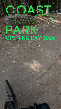
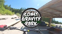
Paul Genovese's recap of the 10th annual Backwoods Jam hosted by Logan Peat at the Coast Gravity Park.
Popular Trail Networks
view all areas »Sub Regions
- Gibsons (62)
- Sprockids (54)
- Halfmoon Bay (1)
- Pender Harbour (106)
- Kleindale (38)
- MiddlePoint (51)
- Nelson Island (0)
- Roberts Creek (230)
- B&K (206)
- Sechelt (355)
- Coast Gravity Park (22)
- Connor Park (25)
- Halfmoon Bay (53)
- Kinnikinnick Park (20)
- Porpoise Bay (27)
- West Sechelt (199)
- Bowen Island (53)
- Keats Island (0)
Popular Southern Sunshine Coast Mountain Biking Trails
• 100 ★ 4.6 • 1 mile • 0 ft • 3,522 •
Fast, fun, flowy with well built at the top, moving into bigger, faster sections through the trees. A couple of big /drops that are well signed, and even with padded trees, just in case. If you're planning on riding anything in this...
• 100 ★ 4.4 • 3,127 ft • 0 ft • 2,853 •
Nice flowy . When connecting over to , avoid the muddy double track by exiting before reaching the bottom of the downhill section and go right on .
• 100 ★ 4.5 • 2,493 ft • 0 ft • 2,510 •
This downhill trail, named in honour of Sprockids founder Doug Detweiler, was built by the Capilano University students starting in 2012 2012 under the guidance of instructors Jay Hoots and Daniel Scott. It can be reached just off of...
• 100 ★ 4.3 • 1,864 ft • 0 ft • 2,275 •
A Sunshine Coast favourite. Classic B&K jump built by one of the Roberts Creek OG builders DY. Big rolls, woodwork, big tabletops and a lot of flow make this a great ride all around.
• 85 ★ 4.7 • 1,201 ft • 0 ft • 1,702 •
Riders are challenged to rail each corner back and forth to keep their momentum and flow up with a mix of big turns, rollers and high speeds.
• 100 ★ 3.6 • 3,389 ft • 67 ft • 1,692 •
Nice single track that is used to connect from to and . Has some nice fast down hill sections.
• 90 ★ 4.6 • 781 ft • 0 ft • 1,662 •
A favourite trail by many, maximum flow and fun is achieved at Dogger's with tabled jumps, hips and mage berms as seen in Ryan Howard's segment in "Arrival".
• 100 ★ 3.9 • 2,437 ft • 0 ft • 1,658 •
Starts loamy and rooty with some fun small , then becomes rougher and looser lower down.
Southern Sunshine Coast Mountain Bike Routes
★ 5.0 • 23 miles • 2,128 ft • 35 •
Day 1 of Great Explorations - Sunshine Coast Challenge! We start in the beautiful trails of Halfmoon Bay...
★ 4.7 • 8 miles • 1,063 ft • 16 •
This route was recommended to us by a local trailbuilder, and it proved to be a lot of fun. Without it,...
★ 5.0 • 63 miles • 9,130 ft • 43 •
Route from Bikepacking.com
★ 5.0 • 7 miles • 965 ft • 29 • Loop •
This fun, little, route takes approximately an hour and 15 minutes. Great for beginners or above beginner...
12 miles • 1,715 ft • 8 • Loop •
Heres a loop that I like to do for a good spring or fall workout. There are options to veer off to...
★ 4.5 • 17 miles • 4,009 ft • 48 • Loop •
This ride has a little bit of everything and will certainly get your legs moving after a week of sitting...
Photos of Southern Sunshine Coast Mountain Bike
Videos of Southern Sunshine Coast Mountain Bike
trail: Auto Pilot
3:10 |
37 |
Apr 4, 2026
trail: Cruise Control
0:44 |
259 |
Jul 2, 2023
trail: Mach Chicken
0:16 |
147 |
Jan 5, 2023

trail: DNZ
0:08 |
25 |
Feb 19, 2022
trail: DNZ
0:08 |
9 |
Feb 19, 2022
trail: Hand Job
0:56 |
193 |
Feb 11, 2022
trail: Coastal Cruise
0:46 |
109 |
Nov 23, 2021
trail: Mach Chicken
0:22 |
233 |
Jul 9, 2021
Current Trail Warnings
| status | trail | date | condition | user | info |
|---|---|---|---|---|---|
| Rock'a'Billy Bypass West Sechelt | Jun 15, 2026 @ 7:31pm (America/Vancouver) Jun 15, 2026 | Unknown | riderenew72 | Badly Motocross blown up | |
| Skullduggery West Sechelt | Jun 15, 2026 @ 6:45pm (America/Vancouver) Jun 15, 2026 | Unknown | riderenew72 | Active logging. Trail no longer exists. ... | |
| Jackson Brothers Road Roberts Creek | Jun 5, 2026 @ 7:34am (America/Vancouver) Jun 5, 2026 | Ideal | nodignoridemtb CMBTA | Closed until end of September due to... |
Recent Trail Reports
| status | trail | date | condition | info | user |
|---|---|---|---|---|---|
| Hwy 102 B&K | Jun 14, 2026 @ 10:04am (America/Vancouver) Jun 14, 2026 | Dry | messajane | ||
| Killer Squirrel West Sechelt | Jun 15, 2026 @ 6:40pm (America/Vancouver) Jun 15, 2026 | Ideal | riderenew72 | ||
| Kinnikinnick (Pink) Kinnikinnick Park | Jun 15, 2026 @ 7:31am (America/Vancouver) Jun 15, 2026 | Ideal | riderenew72 | ||
| Rock'a'Billy West Sechelt | Jun 15, 2026 @ 7:31am (America/Vancouver) Jun 15, 2026 | Variable | riderenew72 | ||
| Lots of Duff (no motos) West Sechelt | Jun 15, 2026 @ 7:31am (America/Vancouver) Jun 15, 2026 | Ideal | riderenew72 | ||
| BRAT Sechelt | Jun 15, 2026 @ 7:31am (America/Vancouver) Jun 15, 2026 | Dry | riderenew72 | ||
| New Frogger West Sechelt | Jun 15, 2026 @ 7:31am (America/Vancouver) Jun 15, 2026 | Dry | riderenew72 | ||
| De-Worm-Me West Sechelt | Jun 15, 2026 @ 7:31am (America/Vancouver) Jun 15, 2026 | Ideal | riderenew72 | ||
| Phareline West Sechelt | Jun 15, 2026 @ 7:31am (America/Vancouver) Jun 15, 2026 | Ideal | riderenew72 | ||
| Wormy Lake Road West Sechelt | Jun 15, 2026 @ 7:31am (America/Vancouver) Jun 15, 2026 | Ideal | riderenew72 |
Activity Feed
| username | action | type | title | date |
|---|---|---|---|---|
| coachsgx85 | wishlist | trail | activity #97298271 and 3 more | Jun 18, 2026 @ 10:50pm 8 hours |
| nodignoridemtb | comment | trail | activity #97293096 | Jun 18, 2026 @ 8:01pm 11 hours |
| MDbWmLfS | wishlist | region | activity #97291698 | Jun 18, 2026 @ 7:31pm 12 hours |
| nodignoridemtb | add | trail | activity #97288734 | Jun 18, 2026 @ 6:30pm 13 hours |
| CMBTA | update | trail | activity #97285369 | Jun 18, 2026 @ 5:24pm 14 hours |
Recent Comments
| username | type | title | comment | date |
|---|---|---|---|---|
| trail | The trail is not closed. Must have been... | Jun 18, 2026 @ 8:01pm 11 hours | ||
| trail | Closed 6/16/26 😩 | Jun 16, 2026 @ 8:30am 3 days | ||
| report | When I rode it, it looked MTBr built but it... | Jun 16, 2026 @ 8:23am 3 days | ||
| report | FYI. Killer Squirrel was 100% built by... | Jun 16, 2026 @ 7:13am Jun 16, 2026 | ||
| trail | Unfortunately badly Motocross tracked. Many... | Jun 15, 2026 @ 7:29pm Jun 15, 2026 |
Local Badges
-

All the Views!0 awarded -
The Blues - Sprockids29 awarded -
The Acs0 awarded -
Fuzzy Doug's Pineapple165 awarded -
No Ferry Traffic3 awarded -

The Coaster 500 awarded
Bike & Skill Parks
| name | type | city | rating |
|---|---|---|---|
| Coast Gravity Park | bike park | Sechelt | |
| Connor Park | skill park | Sechelt | |
| Proctor Bike Park | skill park | Sechelt | |
| jump line | skill park | Roberts Creek |
Local Trail Supporters
![]()
- BTRA
- Bowen Trail Riders Association
![]()
- Wednesday Night Club
- Dylan Broeke
![]()
Activity Type Stats
| activitytype | trails | distance | descent | descent distance | total vertical | rating | global rank | state rank | photos | reports | routes | ridelogs |
|---|---|---|---|---|---|---|---|---|---|---|---|---|
| Mountain Bike | 826 | 529 miles | 122,178 ft | 235 miles | 5,489 ft | 3,336 | 8,154 | 91 | 63,063 | |||
| E-Bike | 753 | 490 miles | 111,736 ft | 217 miles | 4,114 ft | 26 | 7,938 | 11 | 3,474 | |||
| Horse | 86 | 80 miles | 14,600 ft | 31 miles | 3,415 ft | 1 | 1,666 | 133 | ||||
| Hike | 895 | 561 miles | 117,585 ft | 231 miles | 5,515 ft | 91 | 7,653 | 5 | 9,903 | |||
| Trail Running | 867 | 539 miles | 114,800 ft | 225 miles | 5,515 ft | 2 | 7,643 | 3 | 4,869 | |||
| Dirtbike/Moto | 322 | 274 miles | 48,570 ft | 112 miles | 3,612 ft | 69 | 1,823 | 2 | 612 | |||
| Observed Trials | 260 | 252 miles | 41,224 ft | 100 miles | 3,612 ft | 261 | 1 | 33 | ||||
| ATV/ORV/OHV | 139 | 180 miles | 30,869 ft | 76 miles | 3,612 ft | 10 | 1,635 | 116 | ||||
| Snowmobile | 1 | 1 | 2 | |||||||||
| Snowshoe | 7 | 72 | ||||||||||
| Nordic Ski | 14 | 1 | 288 |
Frequently Asked Questions About Southern Sunshine Coast
▼
What are the best places to ride in Southern Sunshine Coast?
Southern Sunshine Coast has 20 areas to explore for mountain biking. The top rated areas are:
▼
What are the highest rated mountain biking trails in Southern Sunshine Coast?
The highest rated mountain biking trails in Southern Sunshine Coast are:
- Dirt Surfer (4.7/5)
- Dynamite Panther (4.7/5)
- Devil's Elbow (4.7/5)
- Twisted Sista's (4.7/5)
- Hand Solo (4.6/5)
▼
What is the best time of the year to ride in Southern Sunshine Coast?
Based on ride log data, the most popular months to ride in Southern Sunshine Coast are:
- July (1,458 activities)
- August (1,169 activities)
- June (861 activities)
▼
What is the longest trail in Southern Sunshine Coast?
The longest trail in Southern Sunshine Coast is Klein Lake to Malaspina at 5.8 miles. View all trails sorted by distance.
Activities
- Southern Sunshine Coast Mountain Biking Trails
- Southern Sunshine Coast E-Biking Trails
- Southern Sunshine Coast Horseback Trails
- Southern Sunshine Coast Hiking Trails
- Southern Sunshine Coast Trail Running Trails
- Southern Sunshine Coast Dirtbiking Trails
- Southern Sunshine Coast Observed Trials Trails
- Southern Sunshine Coast ATVing/Offroading Trails
- Southern Sunshine Coast Snowshoeing Trails
- Southern Sunshine Coast Nordic Skiing Trails
Trails
- Hard trails in Southern Sunshine Coast
- Easy trails in Southern Sunshine Coast
- Favorite trails in Southern Sunshine Coast
- Most ridden trails in Southern Sunshine Coast
- Singletrack in Southern Sunshine Coast
- Viewpoint trails in Southern Sunshine Coast
- Trails with technical features in Southern Sunshine Coast
- Race routes in Southern Sunshine Coast
Points of Interest
- Gibsons Creek Bridge
- McNair Cabin (1050m)
- Mount Steele Cabin (1515m)
- Batchelor Lake Cabin (1070m)
- Edwards Lake Cabin (1123m)
- Pender Hill Summit
- Mount Daniel Summit Overlook Viewpoint
- Mount Daniel Summit
- Homesite Falls Sight
- Triangle Lake Overlook Viewpoint
- Mount Calder (4,797 ft)
- Mount Elphinstone (4,117 ft)
- Mount Hallowell (4,032 ft)
- By canadaka
 Trailforks & contributors
 - Admins: BCBR, TrailsBC, BCORMA, DSBC, wheelmaniac3, bcpunk, CMBTA, SCDBA
- #3013 - 88,800 views
- southern sunshine coast activity log | embed map of Southern Sunshine Coast mountain bike trails | southern sunshine coast mountain biking points of interest polygons
Downloading of trail gps tracks in kml & gpx formats is disabled for Southern Sunshine Coast.