Mountain Bike Idaho
| Type | Trail Association |
|---|---|
| Primary Activity | Mountain Bike |
| Website |
| Geo | |
|---|---|
| Address |
Idaho
United States

|
4
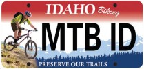
Thanks to the yearlong efforts of many dedicated individuals, Idaho is the first state in the nation to feature a mountain bike-themed license plate. Under the law passed by the Idaho Legislature, this new mountain bike-themed plate will benefit all trail users of Idaho’s 17,000-mile recreational trail system.
The plate costs $35 for the initial purchase and $25 for renewals. The Idaho Department of Parks and Recreation will receive $22 and $12 respectively from plate sales “exclusively for the preservation, maintenance and expansion of recreational trails" within the state of Idaho, where mountain biking is permitted.
The plate features a mountain biker, but all trail users benefit from buying a plate. Recreational trails are used by many, not only to bike, but also to hike, run, wildlife watch, horseback ride and many other activities. So, even if you don't own a mountain bike, but like to recreate on Idaho's trails, you will benefit!
Riding Areas
| name | trails | total descent | highest trail | total distance |
|---|---|---|---|---|
| Alturas Lake | 11 | -500 ft | 2 miles | 22 miles |
| Barracks Lane - Mulkey Creek | 32 | -10,996 ft | 1 mile | 44 miles |
| Bear Basin | 30 | -4,617 ft | 1 mile | 31 miles |
| Bear Lake | 5 | -1,798 ft | 2 miles | 18 miles |
| Bernard Peak | 2 | -79 ft | 5,005 ft | 9 miles |
| Bigwood Fat Bike Park | 4 | -299 ft | 1 mile | 6 miles |
| Blue Creek | 0 | 0 ft | 0 ft | 0 ft |
| Bull Trout Lake | 6 | -18,651 ft | 2 miles | 76 miles |
| Canfield Mountain Trail System | 47 | -20,016 ft | 4,893 ft | 77 miles |
| Capital Hill | 6 | -4,124 ft | 1 mile | 20 miles |
| Castle Rocks | 8 | -920 ft | 1 mile | 5 miles |
| CDT - North Beaverheads | 32 | -26,501 ft | 2 miles | 119 miles |
| Central Caribou Highlands | 28 | -27,565 ft | 2 miles | 110 miles |
| Challis Foothills | 39 | -4,763 ft | 1 mile | 22 miles |
| City of Rocks | 30 | -4,869 ft | 1 mile | 28 miles |
| Craig Mountain | 26 | -8,318 ft | 5,212 ft | 47 miles |
| Deadwood | 16 | -20,143 ft | 1 mile | 81 miles |
| Discovery Hill | 69 | -9,688 ft | 1 mile | 66 miles |
| Dworshak Reservoir | 19 | -4,292 ft | 2,367 ft | 26 miles |
| East of Stanley | 18 | -12,668 ft | 2 miles | 67 miles |
| East Side | 16 | -15,077 ft | 1 mile | 94 miles |
| Eastern Centennials | 0 | 0 ft | 0 ft | 0 ft |
| English Point | 3 | -423 ft | 2,562 ft | 4 miles |
| Feather Creek | 2 | -1,976 ft | 4,250 ft | 14 miles |
| Gold Creek | 10 | -4,391 ft | 5,103 ft | 19 miles |
| Gospel-Hump Wilderness | 2 | -5,133 ft | 2 miles | 24 miles |
| Graham Mountain | 5 | -5,328 ft | 1 mile | 21 miles |
| Harriman State Park | 17 | -2,693 ft | 1 mile | 23 miles |
| Hells Gate | 19 | -2,485 ft | 1,403 ft | 14 miles |
| Heyburn State Park | 11 | -4,965 ft | 3,251 ft | 24 miles |
| Hidden Valley Trails | 7 | -397 ft | 5,070 ft | 3 miles |
| Idaho City Trail System | 15 | -4,773 ft | 1 mile | 26 miles |
| Iron Creek/Hat Creek | 58 | -37,259 ft | 2 miles | 161 miles |
| Italian Peaks | 19 | -21,165 ft | 2 miles | 85 miles |
| Jug Mountain | 39 | -4,760 ft | 1 mile | 23 miles |
| Lakeview Mountain | 0 | 0 ft | 0 ft | 0 ft |
| Lemhi Mountains | 61 | -55,457 ft | 2 miles | 254 miles |
| Little Boulder | 2 | -970 ft | 2,922 ft | 5 miles |
| Lost Creek | 3 | -3,948 ft | 1 mile | 23 miles |
| Lost River Range | 3 | -240 ft | 2 miles | 11 miles |
| Magic Mountain | 136 | -63,744 ft | 2 miles | 478 miles |
| Marble Creek | 20 | -23,257 ft | 1 mile | 109 miles |
| Middle Fork Salmon Wild and Scenic River | 6 | -8,385 ft | 1 mile | 89 miles |
| Mineral Point | 9 | -2,610 ft | 3,038 ft | 16 miles |
| Moscow Mountain | 85 | -20,004 ft | 4,712 ft | 105 miles |
| Mt Coeur D Alene | 16 | -12,001 ft | 4,422 ft | 49 miles |
| North Caribou Highlands | 61 | -50,535 ft | 2 miles | 237 miles |
| North Fork of the Clearwater | 14 | -28,418 ft | 1 mile | 150 miles |
| North of Stanley | 16 | -3,792 ft | 2 miles | 41 miles |
| Palouse Divide | 27 | -18,780 ft | 1 mile | 94 miles |
| Panther Creek/Down River | 17 | -17,290 ft | 1 mile | 80 miles |
| Pebble Creek | 16 | -9,262 ft | 2 miles | 56 miles |
| Pierce Recreational Area | 7 | -7,155 ft | 5,134 ft | 81 miles |
| Ponderosa State Park | 22 | -1,381 ft | 1 mile | 23 miles |
| Post Falls Community Forest | 9 | -839 ft | 2,446 ft | 7 miles |
| Priest Lake | 16 | -9,694 ft | 1 mile | 65 miles |
| Purcell Mountains | 0 | 0 ft | 0 ft | 0 ft |
| Rathdrum Mountain Park | 13 | 0 ft | 0 ft | 0 ft |
| Ryder Park | 2 | -132 ft | 1 mile | 5 miles |
| Schweitzer | 187 | -66,795 ft | 1 mile | 122 miles |
| Shoshoni Plains Nordic | 4 | -92 ft | 1 mile | 3 miles |
| Southern Caribou Highlands | 17 | -11,083 ft | 2 miles | 61 miles |
| Southern Valley Trails | 10 | -1,237 ft | 1 mile | 13 miles |
| St Charles Canyon | 33 | -13,696 ft | 2 miles | 56 miles |
| St. Anthony Sand Dunes | 0 | 0 ft | 0 ft | 0 ft |
| St. Joe River | 10 | -7,131 ft | 1 mile | 24 miles |
| Stormy Peak | 19 | -19,434 ft | 2 miles | 97 miles |
| Sun Valley Nordic Center | 3 | 0 ft | 0 ft | 0 ft |
| Syringa Trail System | 14 | -3,296 ft | 2,658 ft | 18 miles |
| Teton Lakes Winter Park | 4 | -75 ft | 4,865 ft | 6 miles |
| Twelvemile | 38 | -16,373 ft | 2 miles | 64 miles |
| Upper Birch Creek | 17 | -11,852 ft | 2 miles | 57 miles |
| Wagonhammer | 50 | -25,296 ft | 2 miles | 81 miles |
| Warm River | 9 | -4,791 ft | 1 mile | 29 miles |
| West of Stanley | 11 | -5,373 ft | 2 miles | 23 miles |
| Williams Creek | 89 | -52,026 ft | 2 miles | 175 miles |
| Woop Um Up | 8 | -2,808 ft | 1 mile | 16 miles |
| Yankee Fork | 12 | -15,630 ft | 2 miles | 59 miles |