-
DateMonday April 19, 2021 at 7:00am MSTtoSunday April 25, 2021 at 12:00am
past event -
TypeGroup RideXC
-
ActivitiesMountain Bike E-Bike
-
LocationKalamalka Lake Canada
-
Route
-
RegistrationOpen Free
Event Supporters:
Comments
-
+ 0
 nancybussiere
Apr 23, 2021 at 23:57
nancybussiere
Apr 23, 2021 at 23:57
Done Great ride!
[Reply]
Josee-Anne
Apr 23, 2021 at 18:04
Thanks for the great ride!
I had so much fun and some good challenges!
[Reply]
I had so much fun and some good challenges!

LauraM
Apr 22, 2021 at 21:38
Great route! Always a treat not having to climb back outta somewhere!! Did a modified version, had to add the south park loop while we were out there.
[Reply]
Cindypelletier
Apr 22, 2021 at 20:20
Got it done! Screwed up the trail forks! Ugh! Lots of fun and sphincter puckering! For me anyways. Ha ha
[Reply]
 vgarrison
Apr 21, 2021 at 19:44
vgarrison
Apr 21, 2021 at 19:44
Great ride! First time on Cougar Trap. Super fun! Thanks for the route!
[Reply]

 bradandkristen
Apr 20, 2021 at 19:28
bradandkristen
Apr 20, 2021 at 19:28
That was so much fun! Loved discovering Serendipity for the first time  - Kristen
[Reply]
Commenting is disabled for past events.
-
- Download
- Subscribe
-
4interested
-
11going
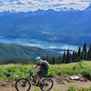
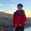
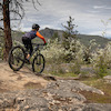
Event Photos


Route
-
Vernon Ladies Shop Ride #3
close-
Layers w
- Weather Layers
- Pro
- Pro
- Pro
- Pro
- Pro
- Pro
- More Layers
- Pro
- Pro
- Pro
- Pro
-
Upgrade to

3DTrail Conditions- Unknown
- Snow Groomed
- Snow Packed
- Snow Covered
- Snow Cover Partial
- Freeze/thaw Cycle
- Icy
- Prevalent Mud
- Wet
- Variable
- Ideal
- Dry
- Very Dry
Trail Flow (Ridden Direction)Trailforks scans users ridelogs to determine the most popular direction each trail is ridden. A good flowing trail network will have most trails flowing in a single direction according to their intension.
The colour categories are based on what percentage of riders are riding a trail in its intended direction.- > 96%
- > 90%
- > 80%
- > 70%
- > 50%
- < 50%
- bi-directional trail
- no data
Trail Last RiddenTrailforks scans ridelogs to determine the last time a trail was ridden.- < 2 days
- < 1 week
- < 2 weeks
- < 1 month
- < 6 months
- > 6 months
Trail Ridden DirectionThe intended direction a trail should be ridden.- Downhill Only
- Downhill Primary
- Both Directions
- Uphill Primary
- Uphill Only
- One Direction
Contribute DetailsColors indicate trail is missing specified detail.- Description
- Photos
- Description & Photos
- Videos
Trail Popularity ?Trailforks scans ridelogs to determine which trails are ridden the most in the last 9 months. Trails are compared with nearby trails in the same city region with a possible 25 colour shades. Think of this as a heatmap, more rides = more kinetic energy = warmer colors.- most popular
- popular
- less popular
- not popular
ATV/ORV/OHV FilterMax Vehicle WidthinchesUS Cell CoverageLegend
Radar TimeActivity RecordingsTrailforks uses anonymized public activity data. ?Activity RecordingsTrailforks uses anonymized public activity data. ?Personal Heatmap▶ Activity Typesall / none▶ Options2Date range month–Winter TrailsWarning A routing network for winter maps does not exist. Selecting trails using the winter trails layer has been disabled.Missing TrailsMost PopularLeast PopularTrails are colored based on popularity. The more popular a trail is, the more red. Less popular trails trend towards green.Jump Magnitude HeatmapHeatmap of where riders jump on trails. Zoom in to see individual jumps, click circles to view jump details.BC Backroad Status
Service Road Atlas is a free to use, community-driven service for viewing and creating reports on the numerous back-country service roads around B.C. and Alberta.
![map legend]() Slope AspectDirection the slope facesTrails DeemphasizedTrails are shown in grey.Only show trails with no bike usage.Suggested LayersBased on selected activity type
Slope AspectDirection the slope facesTrails DeemphasizedTrails are shown in grey.Only show trails with no bike usage.Suggested LayersBased on selected activity typeSave the current map location and zoom level as your default home location whenever this page is loaded.
SaveTrail transparency3.7 milesDistance592 ftClimb-678 ftDescent2,115 ftHigh Point-87 ftAltitude change1,761 ftAltitude min1,848 ftAltitude start1,762 ftAltitude end-0.4%Grade-45%Grade max45.1%Grade min2 milesDistance climb1 mileDistance down1,545 ftDistance flat -
