close
-
Layers w
- Weather Layers
- Pro
- Pro
- Pro
- Pro
- Pro
- Pro
- More Layers
- Pro
- Pro
- Pro
- Pro
-
Upgrade to

3D
Trail Conditions
- Unknown
- Snow Groomed
- Snow Packed
- Snow Covered
- Snow Cover Partial
- Freeze/thaw Cycle
- Icy
- Prevalent Mud
- Wet
- Variable
- Ideal
- Dry
- Very Dry
Trail Flow (Ridden Direction)
Trailforks scans users ridelogs to determine the most popular direction each trail is ridden. A good flowing trail network will have most trails flowing in a single direction according to their intension.
The colour categories are based on what percentage of riders are riding a trail in its intended direction.
The colour categories are based on what percentage of riders are riding a trail in its intended direction.
- > 96%
- > 90%
- > 80%
- > 70%
- > 50%
- < 50%
- bi-directional trail
- no data
Trail Last Ridden
Trailforks scans ridelogs to determine the last time a trail was ridden.
- < 2 days
- < 1 week
- < 2 weeks
- < 1 month
- < 6 months
- > 6 months
Trail Ridden Direction
The intended direction a trail should be ridden.
- Downhill Only
- Downhill Primary
- Both Directions
- Uphill Primary
- Uphill Only
- One Direction
Contribute Details
Colors indicate trail is missing specified detail.
- Description
- Photos
- Description & Photos
- Videos
Trail Popularity ?
Trailforks scans ridelogs to determine which trails are ridden the most in the last 9 months.
Trails are compared with nearby trails in the same city region with a possible 25 colour shades.
Think of this as a heatmap, more rides = more kinetic energy = warmer colors.
- most popular
- popular
- less popular
- not popular
ATV/ORV/OHV Filter
Max Vehicle Width
inches
US Cell Coverage
Legend

Radar Time
Activity Recordings
Trailforks uses anonymized public activity data.
?
Activity Recordings
Trailforks uses anonymized public activity data.
?
Personal Heatmap
▶
Activity Types
all
/
none
▶
Options
2
Date range
month
–
Winter Trails
Warning
A routing network for winter maps does not exist. Selecting trails using the winter trails layer has been disabled.
Missing Trails
Most Popular
Least Popular
Trails are colored based on popularity. The more popular a trail is, the more red. Less popular trails trend towards green.
Jump Magnitude Heatmap
Heatmap of where riders jump on trails. Zoom in to see individual jumps, click circles to view jump details.
BC Backroad Status
![map legend]()
Service Road Atlas is a free to use, community-driven service for viewing and creating reports on the numerous back-country service roads around B.C. and Alberta.

Slope Aspect
Direction the slope faces
Trails Deemphasized
Trails are shown in grey.
Only show trails with no bike usage.
Suggested Layers
Based on selected activity type
Save the current map location and zoom level as your default home location whenever this page is loaded.
SaveA trail network of multi-use trails including motorized, located in the Chelan Sawtooths. Best known for Angel's Staircase, the region offers many backcountry riding options. The two most common trailheads are Crater Creek and Foggy Dew which provide access to a combination of riding loops. There are also several lakes in the region to explore.
Primary Trail Type: Cross-Country
eBikes Allowed:
Yes
Land Status: National Forest
Activities Click to view
- Mountain Bike
52 trails
- E-Bike
42 trails
- Horse
22 trails
- Hike
57 trails
- Trail Running
57 trails
- Dirtbike/Moto
25 trails
- Observed Trials
8 trails
- ATV/ORV/OHV
8 trails
Region Details
- 10
- 3
- 18
- 13
- 1
Region Status
Caution as of May 24, 2026Local Trail Association
Stats
- Avg Trail Rating
- Trails (view details)
- 49
- Trails Mountain Bike
- 53
- Trails E-Bike
- 42
- Trails Horse
- 22
- Trails Hike
- 57
- Trails Trail Running
- 57
- Trails Dirtbike/Moto
- 25
- Trails Observed Trials
- 8
- Trails ATV/ORV/OHV
- 8
- Total Distance
- 138 miles
- Total Descent
- 38,371 ft
- Total Vertical
- 6,806 ft
- Highest Trailhead
- 8,261 ft
- Reports
- 320
- Photos
- 194
- Ridden Counter
- 3,079
Popular Angels Staircase / Uno Peak Trails
• 95 ★ 4.5 • 6 miles • 2,075 ft • 494 •
The first mile descends through mixed Douglas fir and subalpine forest to the stream ford and then switches back, up for 0.75 miles and begins traveling above . At 4 miles the Martin Lake Trail goes off to the right. The route continues...
• 95 ★ 3.2 • 4,531 ft • 752 ft • 447 •
Typically ridden east to west when riding the Angel's Staircase loop. Channel your inner mountain goat to reach the false at the junction with Merchant's Basis #417.1. Once past the junction, the climb becomes manageable to humans up to...
• 95 ★ 4.2 • 2 miles • 147 ft • 436 •
Highly rated popular black diamond difficulty singletrack. This multi-use trail can be used both directions and has a moderate overall physical rating with a 147 ft double black diamond climb. On average it takes 33 minutes to complete this trail.
• 90 ★ 3.0 • 2 miles • 643 ft • 403 •
Once you've made the climb to access this trail, this makes for a great break on the legs. High alpine singletrack that wanders on the edges of the treeline and passing through gorgeous meadows. Note that the trail continues further in...
• 90 ★ 4.1 • 5 miles • 52 ft • 219 •
Fast and flowy single track downhill. Popular with motorcycles.
• 85 ★ 3.9 • 3 miles • 1,189 ft • 196 •
The first mile descends through mixed Douglas fir and subalpine forest to the stream ford and then switches back, up for 0.75 miles and begins traveling above . At 4 miles, the Martin Lake Trail goes off to the right. The route...
• 100 ★ 0.0 • 3,924 ft • 192 ft • 103 •
Popular blue difficulty singletrack. This multi-use trail can be used both directions and has a moderate overall physical rating with a 192 ft black diamond climb.
Mountain Bike Routes
★ 3.5 • 21 miles • 4,843 ft • 8 • Loop •
Angel's Staircase is a physically demanding, epic loop that takes you far from civilization, so bring...
★ 5.0 • 35 miles • 8,352 ft • 23 • Loop •
An alternative even more challenging series of trails that mirrors much of the famous Angels Staircase...
25 miles • 5,574 ft • 4 • Loop •
Climb up the road to the Left on the over to and then down .
19 miles • 2,848 ft • 6 • Point to Point •
This point to point ride in Sawtooth Wilderness has everything you could hope for in a long day's...
15 miles • 2,914 ft • 4 • Point to Point •
This route is e-bike allowed for the full loop, plus if you really want to, you can start at and use your...
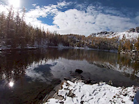
Photos of Angels Staircase / Uno Peak Mountain Bike
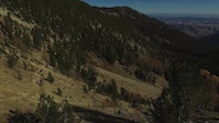
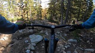
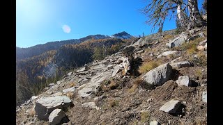
Videos of Angels Staircase / Uno Peak Mountain Bike
trail: Angels Staircase
9:16 |
584 |
Oct 11, 2020
trail: Eagle Lake Trail
5:12 |
20668 |
Jan 26, 2016
trail: Foggy Dew Ridge
28:12 |
304 |
Oct 4, 2023 , Twisp
trail: Foggy Dew Ridge
2:30 |
218 |
Oct 3, 2023 , Twisp
trail: Martin Creek Trail
4:56 |
140 |
Oct 2, 2023 , Twisp

trail: Foggy Dew Trail
4:03 |
347 |
Aug 2, 2023 , Twisp
Current Trail Warnings
| status | trail | date | condition | user | info |
|---|---|---|---|---|---|
| Eagle Lake Trail | May 24, 2026 @ 2:43pm (America/Los_Angeles) May 24, 2026 | Snow Covered | vuke | 30+ downed trees of various size from the... |
Recent Trail Reports
Activity Feed
| username | action | type | title | date |
|---|---|---|---|---|
| kyleiain | wishlist | region | activity #97059807 | Jun 15, 2026 @ 12:38pm Jun 15, 2026 |
| JValenteNW | wishlist | route | activity #96972392 | Jun 14, 2026 @ 8:33am Jun 14, 2026 |
| Kcolbert27 | wishlist | route | activity #96882305 | Jun 13, 2026 @ 8:43am Jun 13, 2026 |
| boxxerace | update | region | activity #96396027 | Jun 6, 2026 @ 12:16pm Jun 6, 2026 |
| boxxerace | like | report | activity #96395938 | Jun 6, 2026 @ 12:15pm Jun 6, 2026 |
Recent Comments
| username | type | title | comment | date |
|---|---|---|---|---|
| trail | Super fun if you like haulin through chunk so... | Sep 8, 2025 @ 8:52am Sep 8, 2025 | ||
| report | Would you mind double checking if you've... | May 30, 2025 @ 10:32am May 30, 2025 | ||
| trail | Amazing descent and backcountry experience. ... | Oct 29, 2024 @ 7:56pm Oct 29, 2024 | ||
| trail | Rode down this and connected to Foggy Dew DH. ... | Oct 29, 2024 @ 7:51pm Oct 29, 2024 | ||
| trail | Super fun descent, probably 50% hikeabike on... | Oct 7, 2024 @ 7:07pm Oct 7, 2024 |
Nearby Areas
| name | distance | ||||
|---|---|---|---|---|---|
| Domke Lake Resort | 11 km | ||||
| Lookout Mountain | 1 | 1 | 12.1 km | ||
| Sun Mountain | 15 | 13 | 2 | 1 | 17.3 km |
| Mad River - Entiat | 5 | 47 | 18 | 17.6 km | |
| Lake Chelan National Rec. Area (North Cascades N.P.) | 3 | 1 | 18.4 km |
Local Badges
-

Completionist0 awarded
Upcoming Local Events
Local Products
Local Products
Activity Type Stats
| activitytype | trails | distance | descent | descent distance | total vertical | rating | global rank | state rank | photos | reports | routes | ridelogs |
|---|---|---|---|---|---|---|---|---|---|---|---|---|
| Mountain Bike | 52 | 129 miles | 35,453 ft | 65 miles | 6,631 ft | #1,752 | #594 | 193 | 323 | 7 | 856 | |
| E-Bike | 42 | 107 miles | 26,135 ft | 54 miles | 6,617 ft | #1,279 | #663 | 304 | 3 | 72 | ||
| Horse | 22 | 68 miles | 17,612 ft | 36 miles | 6,631 ft | #702 | #366 | 148 | 1 | |||
| Hike | 57 | 138 miles | 38,369 ft | 70 miles | 6,808 ft | #1,238 | #601 | 1 | 323 | 4 | 109 | |
| Trail Running | 57 | 138 miles | 38,369 ft | 70 miles | 6,808 ft | #674 | #247 | 323 | 2 | 28 | ||
| Dirtbike/Moto | 25 | 83 miles | 19,829 ft | 44 miles | 6,106 ft | #360 | #99 | 192 | 1 | 35 | ||
| Observed Trials | 8 | 34 miles | 8,202 ft | 24 miles | 5,108 ft | #30 | #9 | 17 | ||||
| ATV/ORV/OHV | 8 | 34 miles | 8,202 ft | 24 miles | 5,108 ft | #440 | #146 | 114 |
Frequently Asked Questions About Angels Staircase / Uno Peak
▼
What are the highest rated mountain biking trails in Angels Staircase / Uno Peak?
The highest rated mountain biking trails in Angels Staircase / Uno Peak are:
- Eagle Lake Trail (4.5/5)
- Martin Creek Trail (4.2/5)
- Angels Staircase (4.1/5)
- Foggy Dew Trail (4/5)
- Uno Peak Trail (4/5)
▼
What is the best time of the year to ride in Angels Staircase / Uno Peak?
Based on ride log data, the most popular months to ride in Angels Staircase / Uno Peak are:
- September (14 activities)
- October (11 activities)
- July (9 activities)
▼
Where can I park to ride in Angels Staircase / Uno Peak?
Check the Angels Staircase / Uno Peak trail map for trailhead and parking information. Community members regularly update access and parking details for trails in the area.
▼
What is the longest trail in Angels Staircase / Uno Peak?
The longest trail in Angels Staircase / Uno Peak is Pasayten Drive Trail at 8.6 miles. View all trails sorted by distance.
Activities
- Angels Staircase / Uno Peak Mountain Biking Trails
- Angels Staircase / Uno Peak E-Biking Trails
- Angels Staircase / Uno Peak Horseback Trails
- Angels Staircase / Uno Peak Hiking Trails
- Angels Staircase / Uno Peak Trail Running Trails
- Angels Staircase / Uno Peak Dirtbiking Trails
- Angels Staircase / Uno Peak Observed Trials Trails
- Angels Staircase / Uno Peak ATVing/Offroading Trails
Trails
- Hard trails in Angels Staircase / Uno Peak
- Easy trails in Angels Staircase / Uno Peak
- Favorite trails in Angels Staircase / Uno Peak
- Most ridden trails in Angels Staircase / Uno Peak
- Singletrack in Angels Staircase / Uno Peak
- Viewpoint trails in Angels Staircase / Uno Peak
- Trails with technical features in Angels Staircase / Uno Peak
- Race routes in Angels Staircase / Uno Peak
- By petkatmat & contributors
- Admins: EMBA-METHOW
- #26328 - 9,958 views
- angels staircase / uno peak activity log | embed map of Angels Staircase / Uno Peak mountain bike trails | angels staircase / uno peak mountain biking points of interest
Downloading of trail gps tracks in kml & gpx formats is enabled for Angels Staircase / Uno Peak.
You must login to download files.