
Open in App
Get this route on your phone instantly.
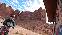
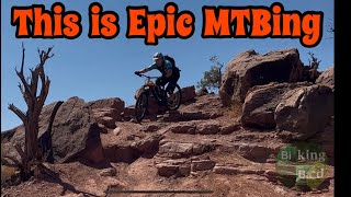
Amasa Back is an awesome riding area with loads of options. For this route we suggest climbing up either the Cliff Hangar jeep road or HyMasa. You do not need to go all the way out on the Pothole Arch trail as this makes for a massive ride, you might just opt to descend down Captain Ahab or for an easier ride right back down HyMasa or Cliff Hanger jeep road.
HyMasa trail is a memorial trail built in honor of Johnny Hymas who was a lifelong cyclist who managed Moab Cyclery for a number of years, he passed leaving a beautiful family of 5 behind. Both of these trails are incredible to ride and have loads of flow (but they are still pleasantly rough) and natural features to play on and jump off of. Such a great ride. Note that the first half of Captain Ahab has lots of climbing, you can bypass some of this climbing by riding the first half of HyMasa then crossing over to the second part of Captain Ahab.
We hope you've been enjoying Trailforks!
Create a FREE account to view route comments and much more.
| 1,601 ft | |||||
| 3 miles | |||||
| 886 ft | |||||
| 207 ft | |||||
| 1 mile | |||||
| 2 miles | |||||
| 1 mile | |||||
| 207 ft | |||||
| 886 ft | |||||
| 1 mile | |||||
| 4 miles | |||||
| 2,280 ft |

Service Road Atlas is a free to use, community-driven service for viewing and creating reports on the numerous back-country service roads around B.C. and Alberta.
Save the current map location and zoom level as your default home location whenever this page is loaded.
Save