


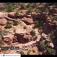
Trails are in Sand Flats Recreation Area. Fee required.
Eagle Eye is at 7000', trail gets snowed out in winter. Check with shops for conditions.
Eagle Eye, Hawks Glide, Falcon Flow, or the Raptor Route is an excellent downhill route that is great on its own or connect if off of the Whole Enchilada. Riders now have an option at the start of LPS to either continue down the Whole Enchilada Route, or take the Raptor Route back toward Moab. This route offers more singletrack, faster downhill, and is more intermediate rider friendly. It also offers many exit options onto Sand Flats Road if you have a mechanical, or just need to get back to town.
Use caution on Eagle Eye and Falcon Flow as they are dual directional trails.
Please stop for uphill traffic.

Local Trail Association
Moab Trail MixStats
-
Distance18 miles
-
Avg time1 hr 22 min
-
Altitude change113 ft
-
Altitude min5,109 ft
-
Altitude start7,271 ft
-
Altitude end7,385 ft
-
Climb2,863 ft
-
Descent-2,750 ft
-
Grade0.1%
-
Grade max-41.5%
-
Grade min42.8%
-
Distance climb9 miles
-
Distance down8 miles
-
Distance flat1 mile
23 Reviews & Comments
We hope you've been enjoying Trailforks!
Create a FREE account to view route comments and much more.
Trails in Route
| 3 miles | |||||
| 2 miles |
Details
-
Riding area
-
Primary ActivityMountain Bike
-
Other Activities
- Hike
- Trail Running
-
Difficulty ratingBlue
-
Route TypePoint to Point
-
eBike Allowed
-
Bike typeAM
-
DirectionBoth Directions
-
Physical ratingModerate
Directions
- Walk northwest on Eagle Eye.
- Continue for 500 meters.
- Walk northwest on Eagle Eye.
- Continue for 500 meters.
- Walk west on Eagle Eye.
- Continue for 800 meters.
- Walk southwest on Eagle Eye.
- Continue for 600 meters.
- Walk northwest on Eagle Eye.
- Continue for 1 kilometer.
- Walk northeast on Eagle Eye.
- Continue for 600 meters.
- Walk southwest on Eagle Eye.
- Continue for 30 meters.
- Walk east on Hawks Glide.
- Continue for 50 meters.
- Walk west on Hawks Glide.
- Continue for 700 meters.
- Walk southwest on Hawks Glide.
- Continue for 700 meters.
- Walk northwest on Hawks Glide.
- Continue for 1.5 kilometers.
- Walk northwest on Hawks Glide.
- Continue for 100 meters.
- Walk west on Kokopelli (Sand Flats Rd).
- Continue for 90 meters.
- Walk west on Kokopelli (Sand Flats Rd).
- Continue for 200 meters.
- Walk north on Falcon Flow.
- Continue for 1 kilometer.
- Walk southwest on Falcon Flow.
- Continue for 1 kilometer.
- Walk west on Falcon Flow.
- Continue for 1.5 kilometers.
- Walk northwest on Falcon Flow.
- Continue for 400 meters.
- Walk west on Falcon Flow.
- Continue for 1.5 kilometers.
- Walk northwest on Falcon Flow.
- Continue for 900 meters.
- Walk southeast on Falcon Flow.
- Continue for 1 kilometer.
- Walk north on Falcon Flow.
- Continue for 900 meters.
- Bike southeast on Kokopelli (Sand Flats Rd).
- Continue for 8 kilometers.
- Bear right to stay on Kokopelli (Sand Flats Rd).
- Continue for 3 kilometers.
- Turn left onto LPS/Raptor Route Access.
- Continue for 30 meters.
- Bike southwest on LPS/Raptor Route Access.
- Continue for 30 meters.
- Turn left onto Kokopelli (Sand Flats Rd).
- Continue for 600 meters.
- Bike southwest on Kokopelli (Sand Flats Rd).
- Continue for 1.5 kilometers.
- Unknown
- Snow Groomed
- Snow Packed
- Snow Covered
- Snow Cover Partial
- Freeze/thaw Cycle
- Icy
- Prevalent Mud
- Wet
- Variable
- Ideal
- Dry
- Very Dry
The colour categories are based on what percentage of riders are riding a trail in its intended direction.
- > 96%
- > 90%
- > 80%
- > 70%
- > 50%
- < 50%
- bi-directional trail
- no data
- < 2 days
- < 1 week
- < 2 weeks
- < 1 month
- < 6 months
- > 6 months
- Downhill Only
- Downhill Primary
- Both Directions
- Uphill Primary
- Uphill Only
- One Direction
- Description
- Photos
- Description & Photos
- Videos
- most popular
- popular
- less popular
- not popular
Service Road Atlas is a free to use, community-driven service for viewing and creating reports on the numerous back-country service roads around B.C. and Alberta.
Save the current map location and zoom level as your default home location whenever this page is loaded.
Save- Singletrack
Photos
Videos
Recent Trail Reports Along Route
| status | trail | date | condition | description |
|---|---|---|---|---|
Jun 22, 2026 @ 8:34am (America/Denver) Jun 22, 2026 | ||||
Jun 22, 2026 @ 8:34am (America/Denver) Jun 22, 2026 |
- By GrandCountyTrails
MTM & contributors - #48887 - 15,765 views

