| Type: |  Sight Sight |
| Activities: |
|
-
4,617Checkins
-
4,617MTB
-
0Hike
-
0Moto
-
0Ski
close
-
Layers w
- Weather Layers
- Pro
- Pro
- Pro
- Pro
- Pro
- Pro
- More Layers
- Pro
- Pro
- Pro
- Pro
-
Upgrade to

3D
Trail Conditions
- Unknown
- Snow Groomed
- Snow Packed
- Snow Covered
- Snow Cover Partial
- Freeze/thaw Cycle
- Icy
- Prevalent Mud
- Wet
- Variable
- Ideal
- Dry
- Very Dry
Trail Flow (Ridden Direction)
Trailforks scans users ridelogs to determine the most popular direction each trail is ridden. A good flowing trail network will have most trails flowing in a single direction according to their intension.
The colour categories are based on what percentage of riders are riding a trail in its intended direction.
The colour categories are based on what percentage of riders are riding a trail in its intended direction.
- > 96%
- > 90%
- > 80%
- > 70%
- > 50%
- < 50%
- bi-directional trail
- no data
Trail Last Ridden
Trailforks scans ridelogs to determine the last time a trail was ridden.
- < 2 days
- < 1 week
- < 2 weeks
- < 1 month
- < 6 months
- > 6 months
Trail Ridden Direction
The intended direction a trail should be ridden.
- Downhill Only
- Downhill Primary
- Both Directions
- Uphill Primary
- Uphill Only
- One Direction
Contribute Details
Colors indicate trail is missing specified detail.
- Description
- Photos
- Description & Photos
- Videos
Trail Popularity ?
Trailforks scans ridelogs to determine which trails are ridden the most in the last 9 months.
Trails are compared with nearby trails in the same city region with a possible 25 colour shades.
Think of this as a heatmap, more rides = more kinetic energy = warmer colors.
- most popular
- popular
- less popular
- not popular
ATV/ORV/OHV Filter
Max Vehicle Width
inches
US Cell Coverage
Legend

Radar Time
Activity Recordings
Trailforks uses anonymized public activity data.
?
Activity Recordings
Trailforks uses anonymized public activity data.
?
Personal Heatmap
▶
Activity Types
all
/
none
▶
Options
2
Date range
month
–
Winter Trails
Warning
A routing network for winter maps does not exist. Selecting trails using the winter trails layer has been disabled.
Missing Trails
Most Popular
Least Popular
Trails are colored based on popularity. The more popular a trail is, the more red. Less popular trails trend towards green.
Jump Magnitude Heatmap
Heatmap of where riders jump on trails. Zoom in to see individual jumps, click circles to view jump details.
BC Backroad Status
![map legend]()
Service Road Atlas is a free to use, community-driven service for viewing and creating reports on the numerous back-country service roads around B.C. and Alberta.

Slope Aspect
Direction the slope faces
Trails Deemphasized
Trails are shown in grey.
Only show trails with no bike usage.
Suggested Layers
Based on selected activity type
Save the current map location and zoom level as your default home location whenever this page is loaded.
SaveThe small town of Clarens often referred to as ‘the jewel’ of the Free State is an enchanting tourist attraction full of art, history and adventure. With its breathtaking landscapes of Majestic Maluti Mountain and the Rooiberge, and an abundance of trees that each reveals its personality with every change of season.
It’s a place that can appeal to just about anyone with its array of choices from extreme sports of 4×4 trails to mild activities. It’s a peaceful place with plenty of fresh air and scenic views, restaurants as well as a world-renowned Titanic Rock.
Titanic Rock is one of the town’s many historical attractions especially since it’s overlooking the entrance to the getaway destination, Clarens. That attracts those from afar and even near as it’s just a few hours’ drive for those who dwell in the hustle and bustle of Durban, Johannesburg and Bloemfontein.
And what uniquely describes Clarens history of its geological and architectural features is what the town is built on, sandstone formation. From the many buildings in the town of homes, restaurants, and nature reserves, places of activity or accommodation and wedding venues.
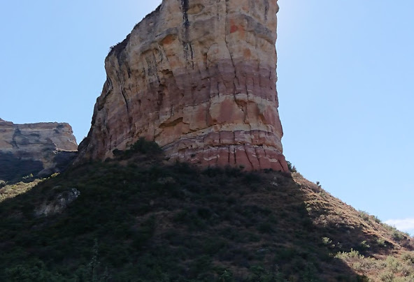
The most notable sandstone cliff in the area is the Titanic rock situated just 2kms north of Clarens. It’s a huge rock that stands like a sentry to welcome all who visit the village. The uniquely shaped rock forms part of Clarens history as it was named by a resident after the Titanic ship tragically sunk. Due to its remarkable resemblance and being shaped like the bow of the ship.
It’s a place that can appeal to just about anyone with its array of choices from extreme sports of 4×4 trails to mild activities. It’s a peaceful place with plenty of fresh air and scenic views, restaurants as well as a world-renowned Titanic Rock.
Titanic Rock is one of the town’s many historical attractions especially since it’s overlooking the entrance to the getaway destination, Clarens. That attracts those from afar and even near as it’s just a few hours’ drive for those who dwell in the hustle and bustle of Durban, Johannesburg and Bloemfontein.
And what uniquely describes Clarens history of its geological and architectural features is what the town is built on, sandstone formation. From the many buildings in the town of homes, restaurants, and nature reserves, places of activity or accommodation and wedding venues.
The most notable sandstone cliff in the area is the Titanic rock situated just 2kms north of Clarens. It’s a huge rock that stands like a sentry to welcome all who visit the village. The uniquely shaped rock forms part of Clarens history as it was named by a resident after the Titanic ship tragically sunk. Due to its remarkable resemblance and being shaped like the bow of the ship.
- By WillieJacobsz
 Trailforks SBP SWW
 - #45205