| Type: |  Cabin Warming Hut, Rustic Cabins Cabin Warming Hut, Rustic Cabins |
| Activities: |
|
-
189Checkins
-
0MTB
-
189Hike
-
0Moto
-
0Ski
close
-
Layers w
- Weather Layers
- Pro
- Pro
- Pro
- Pro
- Pro
- Pro
- More Layers
- Pro
- Pro
- Pro
- Pro
-
Upgrade to

3D
Trail Conditions
- Unknown
- Snow Groomed
- Snow Packed
- Snow Covered
- Snow Cover Partial
- Freeze/thaw Cycle
- Icy
- Prevalent Mud
- Wet
- Variable
- Ideal
- Dry
- Very Dry
Trail Flow (Ridden Direction)
Trailforks scans users ridelogs to determine the most popular direction each trail is ridden. A good flowing trail network will have most trails flowing in a single direction according to their intension.
The colour categories are based on what percentage of riders are riding a trail in its intended direction.
The colour categories are based on what percentage of riders are riding a trail in its intended direction.
- > 96%
- > 90%
- > 80%
- > 70%
- > 50%
- < 50%
- bi-directional trail
- no data
Trail Last Ridden
Trailforks scans ridelogs to determine the last time a trail was ridden.
- < 2 days
- < 1 week
- < 2 weeks
- < 1 month
- < 6 months
- > 6 months
Trail Ridden Direction
The intended direction a trail should be ridden.
- Downhill Only
- Downhill Primary
- Both Directions
- Uphill Primary
- Uphill Only
- One Direction
Contribute Details
Colors indicate trail is missing specified detail.
- Description
- Photos
- Description & Photos
- Videos
Trail Popularity ?
Trailforks scans ridelogs to determine which trails are ridden the most in the last 9 months.
Trails are compared with nearby trails in the same city region with a possible 25 colour shades.
Think of this as a heatmap, more rides = more kinetic energy = warmer colors.
- most popular
- popular
- less popular
- not popular
ATV/ORV/OHV Filter
Max Vehicle Width
inches
US Cell Coverage
Legend

Radar Time
Activity Recordings
Trailforks uses anonymized public activity data.
?
Activity Recordings
Trailforks uses anonymized public activity data.
?
Personal Heatmap
▶
Activity Types
all
/
none
▶
Options
2
Date range
month
–
Winter Trails
Warning
A routing network for winter maps does not exist. Selecting trails using the winter trails layer has been disabled.
Missing Trails
Most Popular
Least Popular
Trails are colored based on popularity. The more popular a trail is, the more red. Less popular trails trend towards green.
Jump Magnitude Heatmap
Heatmap of where riders jump on trails. Zoom in to see individual jumps, click circles to view jump details.
BC Backroad Status
![map legend]()
Service Road Atlas is a free to use, community-driven service for viewing and creating reports on the numerous back-country service roads around B.C. and Alberta.

Slope Aspect
Direction the slope faces
Trails Deemphasized
Trails are shown in grey.
Only show trails with no bike usage.
Suggested Layers
Based on selected activity type
Save the current map location and zoom level as your default home location whenever this page is loaded.
Savehttp://www.randolphmountainclub.org/sheltersinfo/cragcamp.html
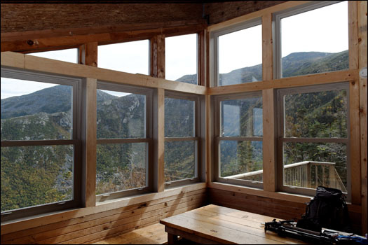
Located at 4,247 feet, on the edge of King Ravine, along the Spur Trail, Crag Camp has fine views of King Ravine, the Knife Edge and much of Northern New Hampshire.
Originally built in 1909, Crag for many years was the private camp of Nelson H. Smith. It has been maintained by the RMC since 1939, and, in 1993, was razed and replaced with a completely new building.
Crag Camp has overnight room for 20 guests. Overnight guests must have money with them to pay for their stay at Gray Knob, Crag Camp and/or The Perch. People without money will be directed to stay at The Log Cabin and still receive a receipt to mail in their fee for that facility. The caretakers can accept cash and credit cards. Canadian money is not accepted at any of our facilities, please plan ahead and carry U.S. funds.
A caretaker is on hand from mid-June through August, and on some of the busier weekends. During the rest of the year, the Gray Knob caretaker visits the facility in the evening to collect overnight fees.
No reservations are accepted, and usage is on a first come, first-served basis. At times when Crag Camp is full, the RMC caretaker may ask some guests to relocate to another RMC facility.
Mattresses are available for use, though guests are encouraged to bring ensolite or thermarest pads.
Counter space and stove boards are provided for cooking. Guests are required to bring their own cooking stoves and utensils.
Water is available from a spring, approximately a quarter mile west on the Gray Knob Trail.
Because of the heavy use the area receives, and its proximity to treeline, Crag Camp is located within a Forest Protection Area. There is no camping permitted within a quarter mile of the cabin. Campers should be aware that, because of unsuitable terrain and vegetation, it will be necessary to travel more than one quarter mile to find a suitable camping location. To protect this fragile area from overuse, U.S. Forest Service backcountry patrollers routinely check the area for illegal camping. Please refer to the White Mountain National Forest Home Page for more information about Forest Protection Areas.
Attached Trail
| trail name | difficulty | riding area |
|---|---|---|
| Spur Trail | Northern Presidentials and The Great Gulf |
- By WillieJacobsz
 Trailforks SBP SWW
 - #60512