| Type: |  Cabin Warming Hut, Rustic Cabins Cabin Warming Hut, Rustic Cabins |
| Activities: |
|
-
275Checkins
-
0MTB
-
275Hike
-
0Moto
-
0Ski
close
-
Layers w
- Weather Layers
- Pro
- Pro
- Pro
- Pro
- Pro
- Pro
- More Layers
- Pro
- Pro
- Pro
- Pro
-
Upgrade to

3D
Trail Conditions
- Unknown
- Snow Groomed
- Snow Packed
- Snow Covered
- Snow Cover Partial
- Freeze/thaw Cycle
- Icy
- Prevalent Mud
- Wet
- Variable
- Ideal
- Dry
- Very Dry
Trail Flow (Ridden Direction)
Trailforks scans users ridelogs to determine the most popular direction each trail is ridden. A good flowing trail network will have most trails flowing in a single direction according to their intension.
The colour categories are based on what percentage of riders are riding a trail in its intended direction.
The colour categories are based on what percentage of riders are riding a trail in its intended direction.
- > 96%
- > 90%
- > 80%
- > 70%
- > 50%
- < 50%
- bi-directional trail
- no data
Trail Last Ridden
Trailforks scans ridelogs to determine the last time a trail was ridden.
- < 2 days
- < 1 week
- < 2 weeks
- < 1 month
- < 6 months
- > 6 months
Trail Ridden Direction
The intended direction a trail should be ridden.
- Downhill Only
- Downhill Primary
- Both Directions
- Uphill Primary
- Uphill Only
- One Direction
Contribute Details
Colors indicate trail is missing specified detail.
- Description
- Photos
- Description & Photos
- Videos
Trail Popularity ?
Trailforks scans ridelogs to determine which trails are ridden the most in the last 9 months.
Trails are compared with nearby trails in the same city region with a possible 25 colour shades.
Think of this as a heatmap, more rides = more kinetic energy = warmer colors.
- most popular
- popular
- less popular
- not popular
ATV/ORV/OHV Filter
Max Vehicle Width
inches
US Cell Coverage
Legend

Radar Time
Activity Recordings
Trailforks uses anonymized public activity data.
?
Activity Recordings
Trailforks uses anonymized public activity data.
?
Personal Heatmap
▶
Activity Types
all
/
none
▶
Options
2
Date range
month
–
Winter Trails
Warning
A routing network for winter maps does not exist. Selecting trails using the winter trails layer has been disabled.
Missing Trails
Most Popular
Least Popular
Trails are colored based on popularity. The more popular a trail is, the more red. Less popular trails trend towards green.
Jump Magnitude Heatmap
Heatmap of where riders jump on trails. Zoom in to see individual jumps, click circles to view jump details.
BC Backroad Status
![map legend]()
Service Road Atlas is a free to use, community-driven service for viewing and creating reports on the numerous back-country service roads around B.C. and Alberta.

Slope Aspect
Direction the slope faces
Trails Deemphasized
Trails are shown in grey.
Only show trails with no bike usage.
Suggested Layers
Based on selected activity type
Save the current map location and zoom level as your default home location whenever this page is loaded.
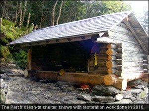
SaveLocated at 4,313 feet, near treeline in Cascade Ravine, RMC's The Perch consists of a lean-to, and four tent platforms. It is located on The Perch Path, a few hundred yards from both the Israel Ridge Path and Randolph Path.
Originally consisting of a birch bark building, built by J. Rayner Edmands in 1892, The Perch was once the highest of a series of shelters in Cascade Ravine, which included Cliff Shelter and Cascade Camp. The original Perch was completely destroyed by the hurricane of September, 1938. The Perch was rebuilt on its original site, in 1948. The construction was supervised by the RMC's Klaus Goetze, and the new facility was dedicated to Louis Fayerweather Cutter. It has since been renovated several times.
http://www.randolphmountainclub.org/sheltersinfo/theperch.html
The current lean-to accommodates 8 persons. Both lean-to and tent platforms are available on a first-come, first-served basis. The RMC caretaker visits the Perch every evening to collect fees. Overnight guests must have money with them to pay for their stay at Gray Knob, Crag Camp and/or The Perch. People without money will be directed to stay at The Log Cabin and still receive a receipt to mail in their fee for that facility. The caretakers can accept cash and credit cards. Canadian money is not accepted at any of our facilities, please plan ahead and carry U.S. funds.
A Bio-Sun, continuous composting toilet, with a liquid filtration system, was installed at The Perch in 1997.
Water is available from Cascade Brook, which crosses The Perch Path approximately 50 yards east of the Perch lean-to.
To maintain the purity of the water supply for future campers, the RMC asks that you wash all dishes in the washpit, located between the lean-to and tent platforms. Please pack out food scraps.
There are no open fires permitted at The Perch.
The Perch is a popular location, particularly with groups. Be prepared with alternate plans, if you are arriving late on a Friday or Saturday evening, or are visiting during a long weekend.
Because of the heavy use the area receives, and its proximity to treeline, The Perch is located within a Forest Protection Area. There is no camping permitted within a quarter mile of the lean-to. Campers should be aware that, because of unsuitable terrain and vegetation, it will be necessary to travel more than one quarter mile to find a suitable camping location. To protect this fragile area from overuse, U.S. Forest Service backcountry patrollers routinely check the area for illegal camping. Please refer to the White Mountain National Forest Home Page for more information about Forest Protection Areas.
- By WillieJacobsz
 Trailforks SBP SWW
 - #60739