close
-
Layers w
- Weather Layers
- Pro
- Pro
- Pro
- Pro
- Pro
- Pro
- More Layers
- Pro
- Pro
- Pro
- Pro
-
Upgrade to

3D
Trail Conditions
- Unknown
- Snow Groomed
- Snow Packed
- Snow Covered
- Snow Cover Partial
- Freeze/thaw Cycle
- Icy
- Prevalent Mud
- Wet
- Variable
- Ideal
- Dry
- Very Dry
Trail Flow (Ridden Direction)
Trailforks scans users ridelogs to determine the most popular direction each trail is ridden. A good flowing trail network will have most trails flowing in a single direction according to their intension.
The colour categories are based on what percentage of riders are riding a trail in its intended direction.
The colour categories are based on what percentage of riders are riding a trail in its intended direction.
- > 96%
- > 90%
- > 80%
- > 70%
- > 50%
- < 50%
- bi-directional trail
- no data
Trail Last Ridden
Trailforks scans ridelogs to determine the last time a trail was ridden.
- < 2 days
- < 1 week
- < 2 weeks
- < 1 month
- < 6 months
- > 6 months
Trail Ridden Direction
The intended direction a trail should be ridden.
- Downhill Only
- Downhill Primary
- Both Directions
- Uphill Primary
- Uphill Only
- One Direction
Contribute Details
Colors indicate trail is missing specified detail.
- Description
- Photos
- Description & Photos
- Videos
Trail Popularity ?
Trailforks scans ridelogs to determine which trails are ridden the most in the last 9 months.
Trails are compared with nearby trails in the same city region with a possible 25 colour shades.
Think of this as a heatmap, more rides = more kinetic energy = warmer colors.
- most popular
- popular
- less popular
- not popular
ATV/ORV/OHV Filter
Max Vehicle Width
inches
US Cell Coverage
Legend

Radar Time
Activity Recordings
Trailforks uses anonymized public activity data.
?
Activity Recordings
Trailforks uses anonymized public activity data.
?
Personal Heatmap
▶
Activity Types
all
/
none
▶
Options
2
Date range
month
–
Winter Trails
Warning
A routing network for winter maps does not exist. Selecting trails using the winter trails layer has been disabled.
Missing Trails
Most Popular
Least Popular
Trails are colored based on popularity. The more popular a trail is, the more red. Less popular trails trend towards green.
Jump Magnitude Heatmap
Heatmap of where riders jump on trails. Zoom in to see individual jumps, click circles to view jump details.
BC Backroad Status
![map legend]()
Service Road Atlas is a free to use, community-driven service for viewing and creating reports on the numerous back-country service roads around B.C. and Alberta.

Slope Aspect
Direction the slope faces
Trails Deemphasized
Trails are shown in grey.
Only show trails with no bike usage.
Suggested Layers
Based on selected activity type
Save the current map location and zoom level as your default home location whenever this page is loaded.
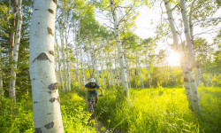
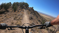
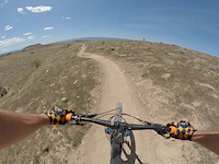
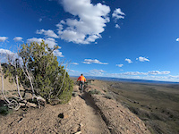
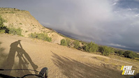
SaveTons of flow and amazing views of the Book Cliffs out at 18 road. Icon trails like Kessel Run and PBR make the dusty drive up the road worth the trip.
AKA: Book Cliffs
Land Status: Regional Recreation Area
Land Manager: BLM - Mesa County
 google parking directions
 Region Supporters & Maintainers
Activities Click to view
- Mountain Bike
73 trails
- E-Bike
71 trails
- Horse
7 trails
- Hike
60 trails
- Trail Running
60 trails
- Dirtbike/Moto
11 trails
- ATV/ORV/OHV
4 trails
Region Details
- 16
- 1
- 16
- 29
- 7
- 1
Region Status
Open as of Jun 9, 2026Local Trail Association
Stats
- Avg Trail Rating
- Trails (view details)
- 70
- Trails Mountain Bike
- 73
- Trails E-Bike
- 71
- Trails Horse
- 7
- Trails Hike
- 60
- Trails Trail Running
- 60
- Trails Dirtbike/Moto
- 11
- Trails ATV/ORV/OHV
- 4
- Total Distance
- 134 miles
- Total Descent
- 11,829 ft
- Total Vertical
- 2,594 ft
- Highest Trailhead
- 7,353 ft
- Reports
- 949
- Photos
- 360
- Ridden Counter
- 67,134
Articles
Colorado's 5 Most Popular Trail Networks According to Trailforks Data
Oct 20, 2021 from pinkbike.com
Colorado is the eighth most expansive of the 50 states by area and is home to 53 different mountain peaks in excess of 14,000 feet above sea level.
Popular 18 Road Mountain Biking Trails
• 100 ★ 4.3 • 2 miles • 21 ft • 6,006 •
AKA: Pumps, Bumps and Rollers Lots of little jumps, some doubles, and some tabletops. Banked and bermed turns. Downhill only. A good intermediate trail where everything can be rolled without issue.
• 100 ★ 4.6 • 1 mile • 29 ft • 5,218 •
Classic ridge trail. Super fun and flowy trail that has some narrow sections of ridge riding, some blind rollers, moderate technical areas, swoop turns. There are some small jumps, but no mandatory gaps. Watch your speed though, as some...
• 100 ★ 4.4 • 1 mile • 0 ft • 4,553 •
Designed by Dave Grossman and built by Singletrack Trails, is one of the favorites among the more advanced locals; it’s got it’s fair share of jumps, gaps, and a large rock garden that typically requires quite a bit of momentum to...
• 95 ★ 4.3 • 2 miles • 136 ft • 4,370 •
This is one of the iconic trails at . Endless undulating singletrack that takes you along the tops of little hills. Some up flow, but mostly fast and down, gotta hit this when here.
• 95 ★ 3.1 • 3,691 ft • 47 ft • 4,174 •
Connector trail that is part of the popular Loop Route
• 100 ★ 4.1 • 2 miles • 444 ft • 3,920 •
Uphill only trail used to access the top of the 18rd Trail system.
• 100 ★ 3.8 • 912 ft • 24 ft • 3,801 •
Popular blue difficulty singletrack. This mountain bike primary trail can be used both directions. On average it takes 2 minutes to complete this trail.
• 100 ★ 4.0 • 518 ft • 22 ft • 3,457 •
This is a directional trail that provides access from the upper parking lot to .
18 Road Mountain Bike Routes
★ 4.2 • 18 miles • 2,188 ft • 8 • Loop •
This is the route you take if you want to hit all the great downhill runs with minimal effort up. Starts...
★ 3.5 • 8 miles • 765 ft • 3 • Loop •
All 3 Zip Trails in the standard loop from the trail head. Starts with a mellow desert climb through...
★ 5.0 • 6 miles • 617 ft • 4 •
Joe's is a classic ridge trail. Super fun and flowy with small optional jumps, gaps and table tops along...
★ 5.0 • 4 miles • 458 ft • 1 •
A fun, swoopy, mellow downhill with some opportunity for steeze for the advanced riders. This trail will...
★ 5.0 • 14 miles • 1,638 ft • 6 •
Matches ride we did in 2013...............
Photos of 18 Road Mountain Bike
Videos of 18 Road Mountain Bike

trail: Zippity Do Dah
0:37 |
138 |
Sep 17, 2021

trail: 18 Road
0:04 |
78 |
May 24, 2021

trail: Joes Ridge
2:33 |
74 |
Apr 24, 2021
trail: Zippity Do Dah
3:44 |
184 |
Nov 7, 2020
trail: PBR
0:18 |
|
May 15, 2020
trail: Zippity Do Dah
0:21 |
105 |
May 13, 2020
trail: PBR
0:51 |
164 |
Jan 29, 2017

trail: Zippity Do Dah
0:35 |
128 |
Jan 29, 2017
Recent Trail Reports
Activity Feed
| username | action | type | title | date |
|---|---|---|---|---|
| jcsimmers | wishlist | route | activity #97257116 | Jun 18, 2026 @ 9:20am 3 days |
| gmbaker33 | wishlist | route | activity #97069420 and 2 more | Jun 15, 2026 @ 3:35pm Jun 15, 2026 |
| Woodsandwatersgal | comment | trail | activity #96758644 | Jun 11, 2026 @ 1:30pm Jun 11, 2026 |
| Woodsandwatersgal | ridden | trail | activity #96747778 | Jun 11, 2026 @ 10:37am Jun 11, 2026 |
| Jwagner190 | ridden | trail | activity #96670407 | Jun 10, 2026 @ 7:05am Jun 10, 2026 |
Recent Comments
| username | type | title | comment | date |
|---|---|---|---|---|
| trail | The most unique trail at 18 Road! | Jun 11, 2026 @ 1:30pm Jun 11, 2026 | ||
| trail | Worst road ever | Jun 2, 2026 @ 4:02pm Jun 2, 2026 | ||
| trail | Garbage. Motos ruined a nice trail. Nothing... | Jun 2, 2026 @ 4:01pm Jun 2, 2026 | ||
| trail | Garbage trail. Anything here open to moto stay... | Jun 2, 2026 @ 3:57pm Jun 2, 2026 | ||
| trail | I felt like I was on the kiddie trail then i... | Jun 2, 2026 @ 3:53pm Jun 2, 2026 |
Nearby Areas
| name | distance | ||||
|---|---|---|---|---|---|
| Highline Lake State Park | 3 | 6 | 10.2 km | ||
| James M. Robb – Colorado River State Park - Fruita Section | 35 | 11.8 km | |||
| Kokopelli Loops | 13 | 15 | 6 | 2 | 13.7 km |
| Colorado State Park | 11 | 15.4 km | |||
| Redlands | 27 | 14 | 1 | 16.7 km |
Local Badges
-

Completionist0 awarded
Activity Type Stats
| activitytype | trails | distance | descent | descent distance | total vertical | rating | global rank | state rank | photos | reports | routes | ridelogs |
|---|---|---|---|---|---|---|---|---|---|---|---|---|
| Mountain Bike | 73 | 134 miles | 11,831 ft | 46 miles | 2,595 ft | #213 | #74 | 333 | 947 | 24 | 26,666 | |
| E-Bike | 71 | 133 miles | 11,827 ft | 46 miles | 2,595 ft | #108 | #545 | 25 | 899 | 3 | 1,358 | |
| Horse | 7 | 36 miles | 3,862 ft | 11 miles | 2,556 ft | #979 | #506 | 122 | 5 | |||
| Hike | 60 | 112 miles | 9,426 ft | 38 miles | 2,595 ft | #1,698 | #741 | 909 | 152 | |||
| Trail Running | 60 | 112 miles | 9,426 ft | 38 miles | 2,595 ft | #1,066 | #330 | 909 | 134 | |||
| Dirtbike/Moto | 11 | 52 miles | 5,335 ft | 17 miles | 2,595 ft | #201 | #84 | 4 | 124 | 1 | 27 | |
| ATV/ORV/OHV | 4 | 21 miles | 906 ft | 3 miles | 2,556 ft | #143 | #40 | 116 | 4 |
Frequently Asked Questions About 18 Road
▼
What are the highest rated mountain biking trails in 18 Road?
The highest rated mountain biking trails in 18 Road are:
- Joes Ridge (4.5/5)
- PBJ (Pumps, Bumps, and Jumps (4.3/5)
- Mojoe (4.3/5)
- Zippity Do Dah (4.3/5)
- PBR (4.2/5)
▼
What is the best time of the year to ride in 18 Road?
Based on ride log data, the most popular months to ride in 18 Road are:
- October (297 activities)
- April (255 activities)
- May (230 activities)
▼
Where can I park to ride in 18 Road?
There are 2 parking locations listed in 18 Road. The most popular parking spots are:
▼
What is the longest trail in 18 Road?
The longest trail in 18 Road is Sarlacc at 7.4 miles. View all trails sorted by distance.
Activities
Trails
Points of Interest
- By brenthillier
 NSMBA TRAILFORKS & contributors
 - Admins: COPMOBA-GVT, COPMOBA-GVT, COPMOBA-GVT
- #3485 - 61,269 views
- 18 road activity log | embed map of 18 Road mountain bike trails | 18 road mountain biking points of interest
Downloading of trail gps tracks in kml & gpx formats is enabled for 18 Road.
You must login to download files.