close
-
Layers w
- Weather Layers
- Pro
- Pro
- Pro
- Pro
- Pro
- Pro
- More Layers
- Pro
- Pro
- Pro
- Pro
-
Upgrade to

3D
Trail Conditions
- Unknown
- Snow Groomed
- Snow Packed
- Snow Covered
- Snow Cover Partial
- Freeze/thaw Cycle
- Icy
- Prevalent Mud
- Wet
- Variable
- Ideal
- Dry
- Very Dry
Trail Flow (Ridden Direction)
Trailforks scans users ridelogs to determine the most popular direction each trail is ridden. A good flowing trail network will have most trails flowing in a single direction according to their intension.
The colour categories are based on what percentage of riders are riding a trail in its intended direction.
The colour categories are based on what percentage of riders are riding a trail in its intended direction.
- > 96%
- > 90%
- > 80%
- > 70%
- > 50%
- < 50%
- bi-directional trail
- no data
Trail Last Ridden
Trailforks scans ridelogs to determine the last time a trail was ridden.
- < 2 days
- < 1 week
- < 2 weeks
- < 1 month
- < 6 months
- > 6 months
Trail Ridden Direction
The intended direction a trail should be ridden.
- Downhill Only
- Downhill Primary
- Both Directions
- Uphill Primary
- Uphill Only
- One Direction
Contribute Details
Colors indicate trail is missing specified detail.
- Description
- Photos
- Description & Photos
- Videos
Trail Popularity ?
Trailforks scans ridelogs to determine which trails are ridden the most in the last 9 months.
Trails are compared with nearby trails in the same city region with a possible 25 colour shades.
Think of this as a heatmap, more rides = more kinetic energy = warmer colors.
- most popular
- popular
- less popular
- not popular
ATV/ORV/OHV Filter
Max Vehicle Width
inches
US Cell Coverage
Legend

Radar Time
Activity Recordings
Trailforks uses anonymized public activity data.
?
Activity Recordings
Trailforks uses anonymized public activity data.
?
Personal Heatmap
▶
Activity Types
all
/
none
▶
Options
2
Date range
month
–
Winter Trails
Warning
A routing network for winter maps does not exist. Selecting trails using the winter trails layer has been disabled.
Missing Trails
Most Popular
Least Popular
Trails are colored based on popularity. The more popular a trail is, the more red. Less popular trails trend towards green.
Jump Magnitude Heatmap
Heatmap of where riders jump on trails. Zoom in to see individual jumps, click circles to view jump details.
BC Backroad Status
![map legend]()
Service Road Atlas is a free to use, community-driven service for viewing and creating reports on the numerous back-country service roads around B.C. and Alberta.

Slope Aspect
Direction the slope faces
Trails Deemphasized
Trails are shown in grey.
Only show trails with no bike usage.
Suggested Layers
Based on selected activity type
Save the current map location and zoom level as your default home location whenever this page is loaded.
SaveSmall in-town trail network with a variety of riding difficulties.
Primary Trail Type: Cross-Country
eBikes Allowed:
No
Land Status: State Park
 google parking directions
 Activities Click to view
- Mountain Bike
12 trails
- Hike
12 trails
- Trail Running
12 trails
Region Details
- 1
- 1
- 5
- 4
- 1
Region Status
Open as of Nov 1, 2025Local Trail Association
Stats
- Avg Trail Rating
- Trails (view details)
- 12
- Trails Mountain Bike
- 13
- Trails Hike
- 12
- Trails Trail Running
- 12
- Total Distance
- 9 miles
- Total Descent
- 1,053 ft
- Total Vertical
- 363 ft
- Highest Trailhead
- 3,264 ft
- Reports
- 80
- Photos
- 19
- Ridden Counter
- 913
Popular 66 Trails Mountain Biking Trails
• 85 ★ 2.5 • 2,784 ft • 19 ft • 113 •
Fun trail in a downhill direction with fast, flowy sections and lots of optional features that can be ridden if desired.
• 95 ★ 2.0 • 4,472 ft • 207 ft • 105 •
This is a wide, easy machine-build trail. Ideal for climbing up to the or as a descent trail for new riders.
• 95 ★ 2.0 • 3,269 ft • 123 ft • 104 •
Fun XC trail that gives a longer option up to the rim. Mostly straightforward but has a couple tricky sections to spice it up. When you hit the utility road continue straight onto Trashalanche! or if you want to test your legs take a...
• 80 ★ 3.4 • 4,459 ft • 138 ft • 93 •
Popular green difficulty singletrack. This mountain bike primary trail can be used both directions and has a easy overall physical rating with a 138 ft green climb. On average it takes 8 minutes to complete this trail.
• 70 ★ 3.6 • 2,923 ft • 58 ft • 82 •
Upper connector trail. Plenty of rocks keep you paying attention, plus some nice rock armoring.
• 85 ★ 4.0 • 1 mile • 113 ft • 75 •
Easy loop with a quick climb and some fast flowy down.
• 75 ★ 1.5 • 2 miles • 52 ft • 74 •
This is a graded & graveled path ideal for strider bikes, walkers and runners. Crosses several times before finishing at the same viewpoint overlooking Prineville.
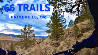
Videos of 66 Trails Mountain Bike
trail: Let 'er Buck
0:20 |
477 |
Nov 6, 2019
trail: The Crossing
2:25 |
152 |
Nov 5, 2019
trail: Rocky Raccoon
8:06 |
257 |
Dec 1, 2021 , Prineville

trail: Brewer's Choice
8:06 |
296 |
Dec 1, 2021 , Prineville

trail: Antiques Roadshow
8:06 |
723 |
Dec 1, 2021 , Prineville

trail: Trashalanche!
8:06 |
273 |
Dec 1, 2021 , Prineville

trail: Rim Trail
8:06 |
378 |
Dec 1, 2021 , Prineville
Recent Trail Reports
| status | trail | date | condition | info | user |
|---|---|---|---|---|---|
| The Crossing | Nov 1, 2025 @ 12:51pm (America/Los_Angeles) Nov 1, 2025 | Unknown | Vande77665 | ||
| Pebbles | Nov 1, 2025 @ 12:51pm (America/Los_Angeles) Nov 1, 2025 | Unknown | Vande77665 | ||
| Let 'er Buck | Nov 1, 2025 @ 12:30pm (America/Los_Angeles) Nov 1, 2025 | Unknown | Vande77665 | ||
| Trashalanche! | Nov 3, 2024 @ 12:26pm Nov 3, 2024 | Ideal | skyeriver8 | ||
| Sporty Berms DH | Nov 3, 2024 @ 12:26pm Nov 3, 2024 | Ideal | skyeriver8 | ||
| Rocky Raccoon | Jun 11, 2024 @ 4:19pm Jun 11, 2024 | Dry | dirttandelight COTA | ||
| Brewer's Choice | Jun 11, 2024 @ 4:18pm Jun 11, 2024 | Dry | dirttandelight COTA | ||
| Gravel Path | Oct 18, 2023 @ 8:25am Oct 18, 2023 | Dry | SubourbonTrails | ||
| Rim Trail | Feb 5, 2022 @ 10:40pm Feb 5, 2022 | Variable | kingdoj1 | ||
| Antiques Roadshow | Nov 21, 2020 @ 5:17pm Nov 21, 2020 | Ideal | casmith9 |
Activity Feed
| username | action | type | title | date |
|---|---|---|---|---|
| mcunnington | wishlist | trail | activity #93682770 | Apr 29, 2026 @ 5:26pm Apr 29, 2026 |
| Mturner3 | wishlist | region | activity #87767418 | Jan 24, 2026 @ 6:29pm Jan 24, 2026 |
| Vande77665 | add | report | activity #83392429 and 2 more | Nov 1, 2025 @ 12:30pm Nov 1, 2025 |
| RootPilot | ridden | trail | activity #82407900 and 2 more | Oct 15, 2025 @ 1:37pm Oct 15, 2025 |
| mason1245 | ridden | trail | activity #79449030 | Sep 1, 2025 @ 3:06pm Sep 1, 2025 |
Recent Comments
| username | type | title | comment | date |
|---|---|---|---|---|
| report | Not fun on bowhead reach or anything for that... | Apr 1, 2025 @ 9:43am Apr 1, 2025 | ||
| report | Not fun on Bowhead Reach or anything really | Apr 1, 2025 @ 9:42am Apr 1, 2025 | ||
| trail | Plenty of rocks to keep you on your toes,... | Jun 11, 2024 @ 4:39pm Jun 11, 2024 | ||
| trail | Fairly easy short loop from the lower... | Jun 11, 2024 @ 4:29pm Jun 11, 2024 | ||
| trail | Fun, short loop, great for beginners, or those... | Jun 11, 2024 @ 4:25pm Jun 11, 2024 |
Nearby Areas
| name | distance | ||||
|---|---|---|---|---|---|
| 66 Trails North | 1 | 1.6 km | |||
| Ochoco Creek Park | 5 | 1.7 km | |||
| Barnes Butte | 14 | 10 | 3 | 1 | 2.9 km |
| Radlands | 4 | 2 | 3 | 13.4 km | |
| Gray Butte | 2 | 10 | 14.1 km |
Local Products
Activity Type Stats
| activitytype | trails | distance | descent | descent distance | total vertical | rating | global rank | state rank | photos | reports | routes | ridelogs |
|---|---|---|---|---|---|---|---|---|---|---|---|---|
| Mountain Bike | 12 | 9 miles | 1,053 ft | 4 miles | 364 ft | #9,103 | #3,566 | 19 | 80 | 798 | ||
| Hike | 12 | 9 miles | 935 ft | 4 miles | 364 ft | #13,639 | #5,841 | 79 | 39 | |||
| Trail Running | 12 | 9 miles | 935 ft | 4 miles | 364 ft | #12,599 | #5,077 | 79 | 18 |
Frequently Asked Questions About 66 Trails
▼
What are the highest rated mountain biking trails in 66 Trails?
The highest rated mountain biking trails in 66 Trails are:
- Brewer's Choice (4/5)
- Pebbles (3.8/5)
- Let 'er Buck (3.8/5)
- Rocky Raccoon (3.8/5)
- The Crossing (3.7/5)
▼
What is the best time of the year to ride in 66 Trails?
Based on ride log data, the most popular months to ride in 66 Trails are:
- May (6 activities)
- March (6 activities)
- October (5 activities)
▼
Where can I park to ride in 66 Trails?
There are 2 parking locations listed in 66 Trails. The most popular parking spots are:
▼
What is the longest trail in 66 Trails?
The longest trail in 66 Trails is Gravel Path at 1.5 miles. View all trails sorted by distance.
- By trailforks
 Trailforks & contributors
 - Admins: COTA
- #18075 - 6,362 views
- 66 trails activity log | embed map of 66 Trails mountain bike trails | 66 trails mountain biking points of interest
Downloading of trail gps tracks in kml & gpx formats is enabled for 66 Trails.
You must login to download files.