close
-
Layers w
- Weather Layers
- Pro
- Pro
- Pro
- Pro
- Pro
- Pro
- More Layers
- Pro
- Pro
- Pro
- Pro
-
Upgrade to

3D
Trail Conditions
- Unknown
- Snow Groomed
- Snow Packed
- Snow Covered
- Snow Cover Partial
- Freeze/thaw Cycle
- Icy
- Prevalent Mud
- Wet
- Variable
- Ideal
- Dry
- Very Dry
Trail Flow (Ridden Direction)
Trailforks scans users ridelogs to determine the most popular direction each trail is ridden. A good flowing trail network will have most trails flowing in a single direction according to their intension.
The colour categories are based on what percentage of riders are riding a trail in its intended direction.
The colour categories are based on what percentage of riders are riding a trail in its intended direction.
- > 96%
- > 90%
- > 80%
- > 70%
- > 50%
- < 50%
- bi-directional trail
- no data
Trail Last Ridden
Trailforks scans ridelogs to determine the last time a trail was ridden.
- < 2 days
- < 1 week
- < 2 weeks
- < 1 month
- < 6 months
- > 6 months
Trail Ridden Direction
The intended direction a trail should be ridden.
- Downhill Only
- Downhill Primary
- Both Directions
- Uphill Primary
- Uphill Only
- One Direction
Contribute Details
Colors indicate trail is missing specified detail.
- Description
- Photos
- Description & Photos
- Videos
Trail Popularity ?
Trailforks scans ridelogs to determine which trails are ridden the most in the last 9 months.
Trails are compared with nearby trails in the same city region with a possible 25 colour shades.
Think of this as a heatmap, more rides = more kinetic energy = warmer colors.
- most popular
- popular
- less popular
- not popular
ATV/ORV/OHV Filter
Max Vehicle Width
inches
US Cell Coverage
Legend

Radar Time
Activity Recordings
Trailforks uses anonymized public activity data.
?
Activity Recordings
Trailforks uses anonymized public activity data.
?
Personal Heatmap
▶
Activity Types
all
/
none
▶
Options
2
Date range
month
–
Winter Trails
Warning
A routing network for winter maps does not exist. Selecting trails using the winter trails layer has been disabled.
Missing Trails
Most Popular
Least Popular
Trails are colored based on popularity. The more popular a trail is, the more red. Less popular trails trend towards green.
Jump Magnitude Heatmap
Heatmap of where riders jump on trails. Zoom in to see individual jumps, click circles to view jump details.
BC Backroad Status
![map legend]()
Service Road Atlas is a free to use, community-driven service for viewing and creating reports on the numerous back-country service roads around B.C. and Alberta.

Slope Aspect
Direction the slope faces
Trails Deemphasized
Trails are shown in grey.
Only show trails with no bike usage.
Suggested Layers
Based on selected activity type
Save the current map location and zoom level as your default home location whenever this page is loaded.
SaveThis region is Unsanctioned, Ride at your own Risk!
Very rocky with loose gravel and sand. Some overgrown trails.
Primary Trail Type: All-Mountain & Downhill
Shuttleable: YES
Land Status: Crown Land
 google parking directions
 Access Info:
Car park at top education road. Shuttle pick up from Mercedes Ct. Note!! Pimpala Rd CANNOT be driven down or up.
Activities Click to view
- Mountain Bike
28 trails
- E-Bike
7 trails
- Hike
21 trails
- Trail Running
21 trails
Region Details
- 5
- 11
- 9
- 2
Region Status
Caution as of Apr 27, 2026Stats
- Avg Trail Rating
- Trails (view details)
- 27
- Trails Mountain Bike
- 28
- Trails E-Bike
- 7
- Trails Hike
- 21
- Trails Trail Running
- 21
- Total Distance
- 6 miles
- Total Descent
- 1,923 ft
- Total Vertical
- 347 ft
- Highest Trailhead
- 911 ft
- Reports
- 24
- Photos
- 8
- Ridden Counter
- 2,150
Popular 80 Acres Mountain Biking Trails
• 65 ★ 4.0 • 2,629 ft • 0 ft • 121 •
Moderately popular double black diamond difficulty singletrack. This mountain bike primary trail can be used downhill only and has a hard overall physical rating with a 0 ft blue climb. It features bridge, drop and jump. On average it takes 6 minutes to complete this trail.
• 60 ★ 5.0 • 1,447 ft • 8 ft • 115 •
Moderately popular black diamond difficulty singletrack. This mountain bike primary trail can be used downhill only and has a moderate overall physical rating with a 8 ft black diamond climb. It features drop. On average it takes 5 minutes to complete this trail.
• 70 ★ 2.0 • 1,045 ft • 13 ft • 114 •
Popular blue difficulty singletrack. This mountain bike primary trail can be used both directions and has a easy overall physical rating with a 13 ft blue climb. On average it takes 1 minutes to complete this trail.
• 60 ★ 3.0 • 2,494 ft • 110 ft • 112 •
Moderately popular green difficulty singletrack. This mountain bike primary trail can be used downhill primary and has a easy overall physical rating with a 110 ft blue climb. On average it takes 5 minutes to complete this trail.
• 45 ★ 0.0 • 1,969 ft • 105 ft • 96 •
Moderately popular black diamond difficulty singletrack. This mountain bike primary trail can be used both directions and has a hard overall physical rating with a 105 ft black diamond climb. On average it takes 5 minutes to complete this trail.
• 80 ★ 4.0 • 2,799 ft • 299 ft • 93 •
Popular blue difficulty singletrack. This mountain bike primary trail can be used uphill primary and has a easy overall physical rating with a 299 ft blue climb. On average it takes 9 minutes to complete this trail.
• 55 ★ 3.0 • 1,792 ft • 12 ft • 73 •
Moderately popular blue difficulty singletrack. This mountain bike primary trail can be used downhill primary and has a moderate overall physical rating with a 12 ft blue climb. On average it takes 3 minutes to complete this trail.
Photos of 80 Acres Mountain Bike
Videos of 80 Acres Mountain Bike
trail: 'Air'ials
0:42 |
918 |
Mar 16, 2021

trail: Down to the fence line
6:27 |
23 |
Apr 30, 2026 , Adelaide

trail: 'Air'ials
6:02 |
172 |
Mar 6, 2025 , Adelaide
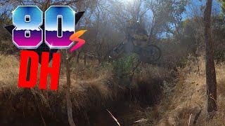
trail: 80's Downhill
8:00 |
241 |
Feb 6, 2025 , Adelaide

trail: 80's Downhill
2:42 |
4230 |
Jan 29, 2019 , Adelaide
Recent Trail Reports
| status | trail | date | condition | info | user |
|---|---|---|---|---|---|
| Waterfall Track | Sep 17, 2025 @ 6:25pm (Australia/Adelaide) Sep 17, 2025 | Ideal | nogo12 | ||
| 'Air'ials | Sep 18, 2022 @ 11:00pm Sep 18, 2022 | Ideal | richo1992 | ||
| Fence-line link | Oct 31, 2021 @ 3:55am Oct 31, 2021 | Dry | JaydenIwZTOZ | ||
| Snake Pit | Sep 7, 2021 @ 10:58pm Sep 7, 2021 | Dry | JaydenIwZTOZ | ||
| XC Downhill | Jun 4, 2020 @ 5:49am Jun 4, 2020 | Variable | danieljacklynch | ||
| 80's Main Climb | Jun 4, 2020 @ 5:48am Jun 4, 2020 | Variable | danieljacklynch | ||
| Tree Huggers | Jun 4, 2020 @ 5:48am Jun 4, 2020 | Variable | danieljacklynch | ||
| Muscles | Jun 4, 2020 @ 5:47am Jun 4, 2020 | Variable | danieljacklynch | ||
| Mercedes Green Link | Jun 4, 2020 @ 5:47am Jun 4, 2020 | Variable | danieljacklynch | ||
| Reflector Trail South | Aug 24, 2019 @ 4:25am Aug 24, 2019 | Variable | Psychrometric |
Activity Feed
| username | action | type | title | date |
|---|---|---|---|---|
| Steven48OEBW | ridden | trail | activity #93932032 | May 3, 2026 @ 4:03am May 3, 2026 |
| skyjogger | add | video | activity #93751579 | Apr 30, 2026 @ 7:17pm Apr 30, 2026 |
| skyjogger | difficultyvote | trail | activity #93751548 | Apr 30, 2026 @ 7:16pm Apr 30, 2026 |
| talonh | ridden | trail | activity #86065427 | Dec 25, 2025 @ 6:45pm Dec 25, 2025 |
| Damiengusset | wishlist | region | activity #83102209 | Oct 27, 2025 @ 12:37am Oct 27, 2025 |
Recent Comments
| username | type | title | comment | date |
|---|---|---|---|---|
| trail | Fast descent with berms, gaps, and steep rock... | May 22, 2024 @ 3:58am May 22, 2024 | ||
| trail | Jump Line including Large Gaps | May 22, 2024 @ 3:56am May 22, 2024 | ||
| trail | I think there is a tree over the track and... | Oct 31, 2021 @ 3:54am Oct 31, 2021 | ||
| trail | Rather dangerously built. crosses over 3 other... | Sep 21, 2020 @ 2:45am Sep 21, 2020 |
Nearby Areas
| name | distance | ||||
|---|---|---|---|---|---|
| Happy valley reservoir | 2.2 km | ||||
| O'Halloran Hill | 10 | 12 | 3 | 4.2 km | |
| Sturt Gorge Recreation Park | 14 | 20 | 3 | 4.2 km | |
| Onkaparinga River National Park | 2 | 18 | 4.9 km | ||
| Hallet Cove Conservation Park | 6 | 5 km |
Local Badges
-

Completionist0 awarded
Activity Type Stats
| activitytype | trails | distance | descent | descent distance | total vertical | rating | global rank | state rank | photos | reports | routes | ridelogs |
|---|---|---|---|---|---|---|---|---|---|---|---|---|
| Mountain Bike | 28 | 6 miles | 1,923 ft | 3 miles | 348 ft | #8,362 | #400 | 8 | 24 | 1,953 | ||
| E-Bike | 7 | 1 mile | 210 ft | 2,513 ft | 308 ft | #6,068 | #319 | 8 | 291 | |||
| Hike | 21 | 4 miles | 1,007 ft | 2 miles | 338 ft | #9,959 | #342 | 19 | 6 | |||
| Trail Running | 21 | 4 miles | 1,007 ft | 2 miles | 338 ft | #9,063 | #323 | 19 | 6 |
Frequently Asked Questions About 80 Acres
▼
What are the highest rated mountain biking trails in 80 Acres?
The highest rated mountain biking trails in 80 Acres are:
- Steeplechase (4.2/5)
- Waterfall Track Link (4.2/5)
- Honeypot (4.1/5)
- Waterfall Track (4.1/5)
- Tanker's (4.1/5)
▼
What is the best time of the year to ride in 80 Acres?
Based on ride log data, the most popular months to ride in 80 Acres are:
- February (15 activities)
- March (13 activities)
- October (12 activities)
▼
Where can I park to ride in 80 Acres?
There are 1 parking locations listed in 80 Acres. The most popular parking spots are:
▼
What is the longest trail in 80 Acres?
The longest trail in 80 Acres is Tanker's at 1.2 km. View all trails sorted by distance.
Activities
Trails
- By Griff-Knight & contributors
- Admins: ForestrySA
- #8150 - 17,139 views
- 80 acres activity log | embed map of 80 Acres mountain bike trails | 80 acres mountain biking points of interest
Downloading of trail gps tracks in kml & gpx formats is enabled for 80 Acres.
You must login to download files.