close
-
Layers w
- Weather Layers
- Pro
- Pro
- Pro
- Pro
- Pro
- Pro
- More Layers
- Pro
- Pro
- Pro
- Pro
-
Upgrade to

3D
Trail Conditions
- Unknown
- Snow Groomed
- Snow Packed
- Snow Covered
- Snow Cover Partial
- Freeze/thaw Cycle
- Icy
- Prevalent Mud
- Wet
- Variable
- Ideal
- Dry
- Very Dry
Trail Flow (Ridden Direction)
Trailforks scans users ridelogs to determine the most popular direction each trail is ridden. A good flowing trail network will have most trails flowing in a single direction according to their intension.
The colour categories are based on what percentage of riders are riding a trail in its intended direction.
The colour categories are based on what percentage of riders are riding a trail in its intended direction.
- > 96%
- > 90%
- > 80%
- > 70%
- > 50%
- < 50%
- bi-directional trail
- no data
Trail Last Ridden
Trailforks scans ridelogs to determine the last time a trail was ridden.
- < 2 days
- < 1 week
- < 2 weeks
- < 1 month
- < 6 months
- > 6 months
Trail Ridden Direction
The intended direction a trail should be ridden.
- Downhill Only
- Downhill Primary
- Both Directions
- Uphill Primary
- Uphill Only
- One Direction
Contribute Details
Colors indicate trail is missing specified detail.
- Description
- Photos
- Description & Photos
- Videos
Trail Popularity ?
Trailforks scans ridelogs to determine which trails are ridden the most in the last 9 months.
Trails are compared with nearby trails in the same city region with a possible 25 colour shades.
Think of this as a heatmap, more rides = more kinetic energy = warmer colors.
- most popular
- popular
- less popular
- not popular
ATV/ORV/OHV Filter
Max Vehicle Width
inches
US Cell Coverage
Legend

Radar Time
Activity Recordings
Trailforks uses anonymized public activity data.
?
Activity Recordings
Trailforks uses anonymized public activity data.
?
Personal Heatmap
▶
Activity Types
all
/
none
▶
Options
2
Date range
month
–
Winter Trails
Warning
A routing network for winter maps does not exist. Selecting trails using the winter trails layer has been disabled.
Missing Trails
Most Popular
Least Popular
Trails are colored based on popularity. The more popular a trail is, the more red. Less popular trails trend towards green.
Jump Magnitude Heatmap
Heatmap of where riders jump on trails. Zoom in to see individual jumps, click circles to view jump details.
BC Backroad Status
![map legend]()
Service Road Atlas is a free to use, community-driven service for viewing and creating reports on the numerous back-country service roads around B.C. and Alberta.

Slope Aspect
Direction the slope faces
Trails Deemphasized
Trails are shown in grey.
Only show trails with no bike usage.
Suggested Layers
Based on selected activity type
Save the current map location and zoom level as your default home location whenever this page is loaded.
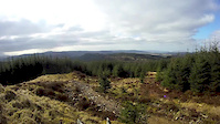
SaveThis gnarly and natural red and black graded trail has all you could wish for on a mountain bike trail – flowing single track, drop-off slabs, berms and optional technical sections. Be ready to meet the Swamp Monster, brave the Water Splash and take on the mighty Murder Hill…
The route is a network of single track sections linked by forest roads, so you can make up your own route and do as much or as little as you like. Do it all and you’ll rack up 12 miles (19.5 km) of riding, with more than 4½ miles (7.4 km) of single track. The single track is red graded, with a couple of optional – and very challenging – black graded sections.
The route is a network of single track sections linked by forest roads, so you can make up your own route and do as much or as little as you like. Do it all and you’ll rack up 12 miles (19.5 km) of riding, with more than 4½ miles (7.4 km) of single track. The single track is red graded, with a couple of optional – and very challenging – black graded sections.
Primary Trail Type: Cross-Country
Land Status: National Forest
 google parking directions
Links
Files
- firetower_trails_leaflet.pdf (1.58 MB)
This region uses the Uk/Euro style trail grading system.
Activities Click to view
- Mountain Bike
15 trails
- E-Bike
15 trails
- Hike
15 trails
- Trail Running
15 trails
Region Details
- 6
- 1
- 7
- 1
Region Status
Open as of Apr 23, 2026Stats
- Avg Trail Rating
- Trails (view details)
- 15
- Trails Mountain Bike
- 15
- Trails E-Bike
- 15
- Trails Horse
- 1
- Trails Hike
- 15
- Trails Trail Running
- 15
- Total Distance
- 14 miles
- Total Descent Distance
- 6 miles
- Total Descent
- 1,825 ft
- Total Vertical
- 691 ft
- Highest Trailhead
- 743 ft
- Reports
- 27
- Photos
- 21
- Ridden Counter
- 555
Popular Achnabreac Mountain Biking Trails
• 60 ★ 3.4 • 3,937 ft • 69 ft • 67 •
Easy red trail descent with forest road climb and amazing panorama views from top. Tiny black trail at top but barely any speed needed for it. Badly signposted with the best trails at the top and the worst at the bottom. Takes ages to...
• 90 ★ 0.0 • 4,446 ft • 92 ft • 63 •
Popular red difficulty singletrack. This mountain bike primary trail can be used downhill primary. On average it takes 5 minutes to complete this trail.
• 65 ★ 0.0 • 912 ft • 12 ft • 62 •
Moderately popular red difficulty singletrack. This mountain bike primary trail can be used downhill primary. On average it takes minutes to complete this trail.
• 75 ★ 0.0 • 2,178 ft • 18 ft • 49 •
Popular red difficulty singletrack. This mountain bike primary trail can be used downhill primary. On average it takes 2 minutes to complete this trail.
• 60 ★ 0.0 • 4,754 ft • 53 ft • 47 •
Moderately popular red difficulty singletrack. This mountain bike primary trail can be used uphill only. On average it takes 8 minutes to complete this trail.
• 70 ★ 0.0 • 919 ft • 33 ft • 39 •
Popular red difficulty singletrack. This mountain bike primary trail can be used uphill primary. On average it takes 1 minutes to complete this trail.
• 95 ★ 0.0 • 469 ft • 3 ft • 39 •
Popular black difficulty singletrack. This mountain bike primary trail can be used one direction. On average it takes 2 minutes to complete this trail.
• 100 ★ 0.0 • 2,316 ft • 45 ft • 10 • • hike
Popular green difficulty gravel path. This hike primary trail can be used both directions. Trail visibility is always easy to follow. On average it takes 2 minutes to complete this trail.
Achnabreac Mountain Bike Routes
• 10 miles • 1,504 ft • 12 •
• 8 miles • 1,451 ft • 9 •
• 7 miles • 1,281 ft • 7 •
Photos of Achnabreac Mountain Bike
Videos of Achnabreac Mountain Bike
trail: Fire Tower
2:19 |
459 |
Mar 15, 2015
trail: Walkers Trail
0:35 |
732 |
Aug 23, 2010
trail: Water Splash
0:04 |
165 |
Jan 19, 2009
Recent Trail Reports
| status | trail | date | condition | info | user |
|---|---|---|---|---|---|
| Rock & Roll | Oct 31, 2024 @ 8:24am Oct 31, 2024 | Prevalent Mud | arhmcleod | ||
| Murder Hill | Oct 31, 2024 @ 8:24am Oct 31, 2024 | Prevalent Mud | arhmcleod | ||
| Murder Hill Bypass | Oct 31, 2024 @ 8:24am Oct 31, 2024 | Prevalent Mud | arhmcleod | ||
| Fire Tower | Oct 31, 2024 @ 8:24am Oct 31, 2024 | Prevalent Mud | arhmcleod | ||
| Forest Road | Oct 31, 2024 @ 8:24am Oct 31, 2024 | Variable | arhmcleod | ||
| The Jink | Oct 31, 2024 @ 8:24am Oct 31, 2024 | Wet | arhmcleod | ||
| Forest Road | Oct 31, 2024 @ 8:24am Oct 31, 2024 | Variable | arhmcleod | ||
| Water Splash | Apr 22, 2019 @ 2:38am Apr 22, 2019 | Very Dry | Chec0 |
Activity Feed
| username | action | type | title | date |
|---|---|---|---|---|
| Cookie37 | ridden | trail | activity #80971618 | Sep 23, 2025 @ 1:16pm Sep 23, 2025 |
| arhmcleod | add | report | activity #61158623 and 6 more | Oct 31, 2024 @ 9:01am Oct 31, 2024 |
| PsychoPete | comment | trail | activity #51476163 | Apr 21, 2024 @ 3:01am Apr 21, 2024 |
| PsychoPete | ridden | trail | activity #51474917 | Apr 21, 2024 @ 2:29am Apr 21, 2024 |
| dougarthur88 | wishlist | region | activity #41287330 | Jun 26, 2023 @ 1:20pm Jun 26, 2023 |
Recent Comments
| username | type | title | comment | date |
|---|---|---|---|---|
| trail | This feature is a red (except when wet). All... | Apr 21, 2024 @ 3:01am Apr 21, 2024 | ||
| trail | Not too hard but beware the rocks can be... | Aug 9, 2019 @ 2:15am Aug 9, 2019 | ||
| trail | This trail is called Twisted Fire Starter | Aug 9, 2019 @ 2:11am Aug 9, 2019 |
Nearby Areas
| name | distance | ||||
|---|---|---|---|---|---|
| Dunardry | 1 | 3 | 3.7 km | ||
| Glenbranter | 13.9 km | ||||
| Dunoon | 1 | 19.2 km | |||
| Glencruitten Woods | 1 | 4 | 22.7 km | ||
| Glencruitten | 2 | 1 | 22.9 km |
Activity Type Stats
| activitytype | trails | distance | descent | descent distance | total vertical | rating | global rank | state rank | photos | reports | routes | ridelogs |
|---|---|---|---|---|---|---|---|---|---|---|---|---|
| Mountain Bike | 15 | 14 miles | 1,824 ft | 6 miles | 692 ft | #8,637 | #292 | 21 | 27 | 1 | 372 | |
| E-Bike | 15 | 14 miles | 1,824 ft | 6 miles | 692 ft | #5,541 | #244 | 25 | 33 | |||
| Horse | 1 | 2,907 ft | 23 ft | 9 | ||||||||
| Hike | 15 | 14 miles | 1,824 ft | 6 miles | 692 ft | #9,542 | #262 | 27 | 10 | |||
| Trail Running | 15 | 14 miles | 1,824 ft | 6 miles | 692 ft | #8,748 | #243 | 27 | 54 |
Frequently Asked Questions About Achnabreac
▼
What are the highest rated mountain biking trails in Achnabreac?
The highest rated mountain biking trails in Achnabreac are:
- Fire Tower (3.8/5)
- Rock & Roll (0/5)
- Black Option (0/5)
- Murder Hill Bypass (0/5)
- The Jink (0/5)
▼
What is the best time of the year to ride in Achnabreac?
Based on ride log data, the most popular months to ride in Achnabreac are:
- October (5 activities)
- April (2 activities)
- September (1 activities)
▼
Where can I park to ride in Achnabreac?
There are 1 parking locations listed in Achnabreac. The most popular parking spots are:
▼
What is the longest trail in Achnabreac?
The longest trail in Achnabreac is Murder Hill at 1.4 miles. View all trails sorted by distance.
- By I4MSTEVE & contributors
- Admins: apply
- #7613 - 5,914 views
- achnabreac activity log | embed map of Achnabreac mountain bike trails | achnabreac mountain biking points of interest polygons
Downloading of trail gps tracks in kml & gpx formats is enabled for Achnabreac.
You must login to download files.