close
-
Layers w
- Weather Layers
- Pro
- Pro
- Pro
- Pro
- Pro
- Pro
- More Layers
- Pro
- Pro
- Pro
- Pro
-
Upgrade to

3D
Trail Conditions
- Unknown
- Snow Groomed
- Snow Packed
- Snow Covered
- Snow Cover Partial
- Freeze/thaw Cycle
- Icy
- Prevalent Mud
- Wet
- Variable
- Ideal
- Dry
- Very Dry
Trail Flow (Ridden Direction)
Trailforks scans users ridelogs to determine the most popular direction each trail is ridden. A good flowing trail network will have most trails flowing in a single direction according to their intension.
The colour categories are based on what percentage of riders are riding a trail in its intended direction.
The colour categories are based on what percentage of riders are riding a trail in its intended direction.
- > 96%
- > 90%
- > 80%
- > 70%
- > 50%
- < 50%
- bi-directional trail
- no data
Trail Last Ridden
Trailforks scans ridelogs to determine the last time a trail was ridden.
- < 2 days
- < 1 week
- < 2 weeks
- < 1 month
- < 6 months
- > 6 months
Trail Ridden Direction
The intended direction a trail should be ridden.
- Downhill Only
- Downhill Primary
- Both Directions
- Uphill Primary
- Uphill Only
- One Direction
Contribute Details
Colors indicate trail is missing specified detail.
- Description
- Photos
- Description & Photos
- Videos
Trail Popularity ?
Trailforks scans ridelogs to determine which trails are ridden the most in the last 9 months.
Trails are compared with nearby trails in the same city region with a possible 25 colour shades.
Think of this as a heatmap, more rides = more kinetic energy = warmer colors.
- most popular
- popular
- less popular
- not popular
ATV/ORV/OHV Filter
Max Vehicle Width
inches
US Cell Coverage
Legend

Radar Time
Activity Recordings
Trailforks uses anonymized public activity data.
?
Activity Recordings
Trailforks uses anonymized public activity data.
?
Personal Heatmap
▶
Activity Types
all
/
none
▶
Options
2
Date range
month
–
Winter Trails
Warning
A routing network for winter maps does not exist. Selecting trails using the winter trails layer has been disabled.
Missing Trails
Most Popular
Least Popular
Trails are colored based on popularity. The more popular a trail is, the more red. Less popular trails trend towards green.
Jump Magnitude Heatmap
Heatmap of where riders jump on trails. Zoom in to see individual jumps, click circles to view jump details.
BC Backroad Status
![map legend]()
Service Road Atlas is a free to use, community-driven service for viewing and creating reports on the numerous back-country service roads around B.C. and Alberta.

Slope Aspect
Direction the slope faces
Trails Deemphasized
Trails are shown in grey.
Only show trails with no bike usage.
Suggested Layers
Based on selected activity type
Save the current map location and zoom level as your default home location whenever this page is loaded.
SaveAdams Camp is a 513 acre conserved property consists of 5 trails and 4.96 miles of multi-use trails suitable for mountain biking. The property sits adjacent to the Ranch Valley, a historic winter recreation area that supported the birth of skiing in Stowe. Trails found on the Adams Camp property, including portions of the Catamount Trail and Stowe Derby Trail, provides access to a large trail network in Ranch Valley, Mt Mansfield State Forest and private trails owned by Trapp Family Lodge.
The effort to conserve the Adams Camp property was undertaken by Stowe Land Trust (SLT) in mid-2004 and was completed with funds from over 550 supporters. It is STP’s second most ridden trail pod and has an eclectic mix of doubletrack, technical singletrack and flow.
The effort to conserve the Adams Camp property was undertaken by Stowe Land Trust (SLT) in mid-2004 and was completed with funds from over 550 supporters. It is STP’s second most ridden trail pod and has an eclectic mix of doubletrack, technical singletrack and flow.
Primary Trail Type: Cross-Country
Land Status: Managed by Local Riding Association
 google parking directions
 Access Info:
Turn left off Route 108 (past the Matterhorn) onto Ranch Brook Road. Follow doubletrack on your right, passing red house. Continue 0.25 miles to parking area.
Region Supporters & Maintainers
![Town of Stowe]()
Town of StoweSponsor![]()
Stowe Land TrustSponsor![Stowe Trails Partnership Trail Crew]()
Stowe Trails Partnership Trail Crew
since 2020Sponsor
Activities Click to view
- Mountain Bike
12 trails
- E-Bike
10 trails
- Hike
15 trails
- Trail Running
14 trails
- Snowshoe
1 trails
- Nordic Ski
4 trails
Region Details
- 1
- 4
- 6
- 1
Region Status
Caution as of 1 dayStats
- Avg Trail Rating
- Trails (view details)
- 17
- Trails Mountain Bike
- 12
- Trails E-Bike
- 10
- Trails Gravel Bike
- 2
- Trails Winter Fat Bike
- 9
- Trails Hike
- 15
- Trails Trail Running
- 14
- Trails Snowshoe
- 1
- Trails Backcountry Ski
- 1
- Trails Nordic Ski
- 4
- Total Distance
- 13 miles
- Total Descent
- 3,340 ft
- Total Vertical
- 1,135 ft
- Highest Trailhead
- 1,922 ft
- Reports
- 3,519
- Photos
- 82
- Ridden Counter
- 15,677
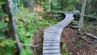
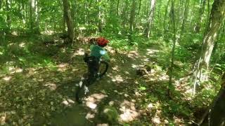
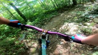
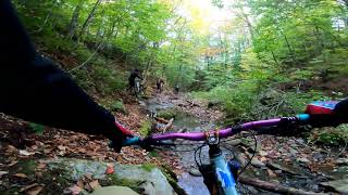
Popular Adams Camp Mountain Biking Trails
• 85 ★ 3.5 • 1 mile • 438 ft • 1,718 •
Built in 2010 by Sustainable Trailworks this trail is consistently graded with very few rocks or roots. Switchbacks, wide bridges and an old forest road. Works as a downhill but ridden primarily as the climbing portion of a loop with...
• 85 ★ 4.4 • 1 mile • 517 ft • 1,287 •
Built in 2018, and located within a shout of the end of the Rec Path, is a bi-directional trail that will become a key part of your next loop in ~whether a starting place to head up to the Trapps cabin, or the connection on your all day...
• 85 ★ 5.0 • 528 ft • 0 ft • 1,191 •
Popular black diamond difficulty singletrack. This multi-use trail can be used downhill only and has a hard overall physical rating. Trail visibility is always easy to follow. On average it takes minutes to complete this trail.
• 85 ★ 5.0 • 3,599 ft • 35 ft • 1,011 •
TUCXS is named in memory of Ted Preston. The name TUCXS: Ted’s Unicorn Express originated as a fundraiser for the Dana Farber Cancer Institute. In November 2018, family, friends, and colleagues lost a beloved father, husband, friend,...
Adams Camp Mountain Bike Routes
★ 3.5 • 6 miles • 977 ft • 9 •
Similar to the clockwise but an easier downhill (Hardys Haul). Park at the end of Ranch Brook Road and...
★ 3.0 • 8 miles • 1,442 ft • 11 •
Intermediate to advanced loop of from the end of the Stowe Recreation Path .Park at the end of the Stowe...
★ 2.0 • 10 miles • 1,269 ft • 8 •
Brewery to Cabin to /Tucks/ /Brewery
★ 3.3 • 13 miles • 1,824 ft • 22 •
An intermediate to advanced loop from the Stowe High School. Park at Stowe High School. This route...
12 miles • 1,639 ft • 20 •
An intermediate to advanced loop from the Stowe High School. Park at Stowe High School
• 16 miles • 2,411 ft • 10 •
Photos of Adams Camp Mountain Bike
Videos of Adams Camp Mountain Bike
4:04 |
477 |
Sep 24, 2023 , Stowe
trail: Haulapalooza
0:59 |
762 |
Aug 2, 2022 , Stowe
trail: Shredder
3:07 |
1316 |
Aug 24, 2020 , Stowe
trail: Haulapalooza
9:40 |
1325 |
Oct 8, 2019 , Stowe
Recent Trail Reports
| status | trail | date | condition | info | user |
|---|---|---|---|---|---|
| TUCXS (Teds Unicorn Express) | Jun 16, 2026 @ 4:59pm (America/New_York) 1 day | Unknown | lucynvt STP | ||
| Stowe Derby | Jun 16, 2026 @ 4:59pm (America/New_York) 1 day | Unknown | lucynvt STP | ||
| Shredder | Jun 16, 2026 @ 4:59pm (America/New_York) 1 day | Unknown | lucynvt STP | ||
| Serenity and Adrenaline Part 1 | Jun 16, 2026 @ 4:59pm (America/New_York) 1 day | Unknown | lucynvt STP | ||
| Pipeline | Jun 16, 2026 @ 4:59pm (America/New_York) 1 day | Unknown | lucynvt STP | ||
| Lower Derby Trail | Jun 16, 2026 @ 4:59pm (America/New_York) 1 day | Unknown | lucynvt STP | ||
| Kimmer's | Jun 16, 2026 @ 4:59pm (America/New_York) 1 day | Unknown | lucynvt STP | ||
| Haulapalooza Down Only | Jun 16, 2026 @ 4:59pm (America/New_York) 1 day | Unknown | lucynvt STP | ||
| Haulapalooza | Jun 16, 2026 @ 4:58pm (America/New_York) 1 day | Unknown | lucynvt STP | ||
| Hardy Haul | Jun 16, 2026 @ 4:58pm (America/New_York) 1 day | Unknown | lucynvt STP |
Activity Feed
| username | action | type | title | date |
|---|---|---|---|---|
| lucynvt | add | report | activity #97136429 and 14 more | Jun 16, 2026 @ 1:58pm 1 day |
| lucynvt | add | report | activity #97032011 and 14 more | Jun 15, 2026 @ 4:22am 3 days |
| stoweshred | add | report | activity #96600959 and 10 more | Jun 9, 2026 @ 6:18am Jun 9, 2026 |
| lucynvt | add | report | activity #96450252 and 14 more | Jun 7, 2026 @ 5:33am Jun 7, 2026 |
| stoweshred | add | report | activity #96450191 and 14 more | Jun 7, 2026 @ 5:33am Jun 7, 2026 |
Recent Comments
| username | type | title | comment | date |
|---|---|---|---|---|
| trail | Large wasp nest noted on the underside of the... | Aug 25, 2025 @ 12:01pm Aug 25, 2025 | ||
| trail | Lots of pedaling and poorly maintained root... | Aug 21, 2025 @ 8:20am Aug 21, 2025 | ||
| trail | My least favorite trail in stowe....the guide... | Jul 14, 2025 @ 8:05am Jul 14, 2025 | ||
| trail | A huge amount of materials and labor went into... | Apr 21, 2025 @ 12:45pm Apr 21, 2025 | ||
| trail | Loaded with down trees from logging. | Oct 18, 2024 @ 12:05pm Oct 18, 2024 |
Nearby Areas
| name | distance | ||||
|---|---|---|---|---|---|
| von Trapp Family Lodge & Resort | 4 | 11 | 3 | 1.3 km | |
| Edson Hill | 2 km | ||||
| Planned Trails | 2.4 km | ||||
| Cottonbrook Nebraska Network | 1 | 3.3 km | |||
| Cady Hill Forest | 14 | 15 | 9 | 3.9 km |
Activity Type Stats
| activitytype | trails | distance | descent | descent distance | total vertical | rating | global rank | state rank | photos | reports | routes | ridelogs |
|---|---|---|---|---|---|---|---|---|---|---|---|---|
| Mountain Bike | 12 | 10 miles | 2,080 ft | 5 miles | 1,135 ft | #2,285 | #779 | 82 | 3,519 | 5 | 6,279 | |
| E-Bike | 10 | 9 miles | 1,470 ft | 4 miles | 1,135 ft | #5,989 | #1,684 | 573 | 103 | |||
| Gravel Bike | 2 | 5,082 ft | 23 ft | 869 ft | 144 ft | #1,079 | #556 | 595 | 16 | |||
| Winter Fat Bike | 9 | 8 miles | 1,037 ft | 3 miles | 978 ft | #1,079 | #556 | 542 | ||||
| Hike | 15 | 11 miles | 2,762 ft | 6 miles | 1,129 ft | #9,989 | #3,891 | 3,511 | 3 | 257 | ||
| Trail Running | 14 | 9 miles | 2,329 ft | 5 miles | 1,007 ft | #10,281 | #3,822 | 3,503 | 4 | 87 | ||
| Snowshoe | 1 | 3,179 ft | 39 ft | 141 ft | #1,085 | #543 | 3,028 | 4 | ||||
| Backcountry Ski | 1 | 3,179 ft | 39 ft | 141 ft | 6 | 104 | ||||||
| Nordic Ski | 4 | 2 miles | 344 ft | 4,803 ft | 322 ft | #789 | #305 | 3,028 | 233 |
Frequently Asked Questions About Adams Camp
▼
What are the highest rated mountain biking trails in Adams Camp?
The highest rated mountain biking trails in Adams Camp are:
- Serenity and Adrenaline Part 1 (4.4/5)
- Haulapalooza Down Only (4.3/5)
- TUCXS (Teds Unicorn Express) (4.3/5)
- Cheddar (4.3/5)
- Pipeline (4.3/5)
▼
What is the best time of the year to ride in Adams Camp?
Based on ride log data, the most popular months to ride in Adams Camp are:
- July (249 activities)
- August (189 activities)
- September (165 activities)
▼
Where can I park to ride in Adams Camp?
There are 2 parking locations listed in Adams Camp. The most popular parking spots are:
▼
What is the longest trail in Adams Camp?
The longest trail in Adams Camp is Pipeline at 1.5 miles. View all trails sorted by distance.
Activities
Trails
- By boarderpunk & contributors
- Admins: STP, STP, StoweNordic, cbrunner9, STP, STP
- #5858 - 32,670 views
- adams camp activity log | embed map of Adams Camp mountain bike trails | adams camp mountain biking points of interest
Downloading of trail gps tracks in kml & gpx formats is enabled for Adams Camp.
You must login to download files.