close
-
Layers w
- Weather Layers
- Pro
- Pro
- Pro
- Pro
- Pro
- Pro
- More Layers
- Pro
- Pro
- Pro
- Pro
-
Upgrade to

3D
Trail Conditions
- Unknown
- Snow Groomed
- Snow Packed
- Snow Covered
- Snow Cover Partial
- Freeze/thaw Cycle
- Icy
- Prevalent Mud
- Wet
- Variable
- Ideal
- Dry
- Very Dry
Trail Flow (Ridden Direction)
Trailforks scans users ridelogs to determine the most popular direction each trail is ridden. A good flowing trail network will have most trails flowing in a single direction according to their intension.
The colour categories are based on what percentage of riders are riding a trail in its intended direction.
The colour categories are based on what percentage of riders are riding a trail in its intended direction.
- > 96%
- > 90%
- > 80%
- > 70%
- > 50%
- < 50%
- bi-directional trail
- no data
Trail Last Ridden
Trailforks scans ridelogs to determine the last time a trail was ridden.
- < 2 days
- < 1 week
- < 2 weeks
- < 1 month
- < 6 months
- > 6 months
Trail Ridden Direction
The intended direction a trail should be ridden.
- Downhill Only
- Downhill Primary
- Both Directions
- Uphill Primary
- Uphill Only
- One Direction
Contribute Details
Colors indicate trail is missing specified detail.
- Description
- Photos
- Description & Photos
- Videos
Trail Popularity ?
Trailforks scans ridelogs to determine which trails are ridden the most in the last 9 months.
Trails are compared with nearby trails in the same city region with a possible 25 colour shades.
Think of this as a heatmap, more rides = more kinetic energy = warmer colors.
- most popular
- popular
- less popular
- not popular
ATV/ORV/OHV Filter
Max Vehicle Width
inches
US Cell Coverage
Legend

Radar Time
Activity Recordings
Trailforks uses anonymized public activity data.
?
Activity Recordings
Trailforks uses anonymized public activity data.
?
Personal Heatmap
▶
Activity Types
all
/
none
▶
Options
2
Date range
month
–
Winter Trails
Warning
A routing network for winter maps does not exist. Selecting trails using the winter trails layer has been disabled.
Missing Trails
Most Popular
Least Popular
Trails are colored based on popularity. The more popular a trail is, the more red. Less popular trails trend towards green.
Jump Magnitude Heatmap
Heatmap of where riders jump on trails. Zoom in to see individual jumps, click circles to view jump details.
BC Backroad Status
![map legend]()
Service Road Atlas is a free to use, community-driven service for viewing and creating reports on the numerous back-country service roads around B.C. and Alberta.

Slope Aspect
Direction the slope faces
Trails Deemphasized
Trails are shown in grey.
Only show trails with no bike usage.
Suggested Layers
Based on selected activity type
Save the current map location and zoom level as your default home location whenever this page is loaded.
SavePopular Trail Networks
view all areas »
No description for Adelaide has been added yet!
Login or register to submit one.
Activities Click to view
- Mountain Bike
873 trails
- E-Bike
506 trails
- Gravel Bike
0 trails
- Adaptive Bike
0 trails
- Winter Fat Bike
0 trails
- Horse
18 trails
- Hike
804 trails
- Trail Running
797 trails
- Dirtbike/Moto
9 trails
- ATV/ORV/OHV
30 trails
Region Details
- 185
- 31
- 185
- 336
- 81
- 17
Region Status
Open as of 2 daysLocal Trail Association
Stats
- Avg Trail Rating
- Trails (view details)
- 919
- Trails Mountain Bike
- 873
- Trails E-Bike
- 506
- Trails Horse
- 18
- Trails Hike
- 804
- Trails Trail Running
- 797
- Trails Dirtbike/Moto
- 9
- Trails ATV/ORV/OHV
- 30
- Trails Snowmobile
- 1
- Trails Snowshoe
- 1
- Trails Downhill Ski
- 1
- Trails Backcountry Ski
- 1
- Trails Nordic Ski
- 1
- Total Distance
- 690 miles
- Total Descent
- 109,679 ft
- Total Vertical
- 2,338 ft
- Highest Trailhead
- 2,342 ft
- Reports
- 6,076
- Photos
- 845
- Ridden Counter
- 164,901
Articles

Video: Railing Corners in Australia with 15-Year-Old Zarah Mitchell
Apr 15, 2022 from pinkbike.com
Zarah Mitchell likes flat pedals and downhill trails.

Video: Troy Brosnan Shreds His Home Trails
Feb 26, 2020 from pinkbike.com
Mr Consistent shows off the trails he grew up riding
Sub Regions
-
80 Acres
- 5
- 11
- 9
- 2
-
Anstey Hill Recreation Park
- 3
- 13
- 2
-
Belair National Park
- 1
- 7
- 35
- 1
-
Bells Gully (Prospect Hill)
- 7
- 14
- 1
-
Bennetts
- 1
- 2
- 3
- 1
-
Black Hill Conservation Park
- 1
- 1
-
Blackwood Forest Recreation Park
- 4
- 6
- 1
-
Brownhill Creek
- 8
- 5
- 6
- 1
-
Cleland National Park
- 11
- 16
- 5
-
Cobbler Creek
- 4
- 13
- 4
- 1
-
Eagle Mountain Bike Park
- 3
- 22
- 6
- 2
-
Fox Creek Bike Park
- 14
- 23
- 6
- 2
-
Hallet Cove Conservation Park
- 6
-
Happy valley reservoir
-
Hope Valley
- 2
-
Kersbrook Forest
- 4
-
Kyeema Conservation Park
- 4
-
Lynton
-
Morialta Conservation Park
- 2
- 22
-
Mount Barker District
- 5
- 4
-
Mt Osmond
- 3
- 6
- 10
- 3
-
O'Halloran Hill
- 10
- 12
- 3
-
Old Kersbrook Forest
- 1
-
Onkaparinga River National Park
- 2
- 18
-
Onkaparinga River Recreation Park
- 2
- 1
-
Randell Park Reserve
- 3
- 1
-
Randell Reserve
- 14
- 29
- 11
- 1
-
Sellicks Hill MTB
- 2
- 3
-
Shepherds Hill Recreation Park
- 11
- 6
- 1
-
Sturt Gorge Recreation Park
- 14
- 20
- 3
-
Totness Recreation Park
- 3
- 4
-
Waite Conservation Reserve
- 10
- 8
-
Walkley Heights
-
Wynn Vale
- 3
Popular Adelaide Mountain Biking Trails
• 95 ★ 3.7 • 4,278 ft • 224 ft • 801 •
This intermediate climbing trail is perfect for riders wanting to return to the west node trailhead and features tight corners and great views of the Spencer Gulf and Glenelg.
• 80 ★ 4.2 • 2,314 ft • 11 ft • 750 •
An intermediate descending only trail, perfect for MTB enthusiasts and riders looking to progress from easier trails. This trail features fast, bermed corners and rock features.
• 80 ★ 4.9 • 1 mile • 39 ft • 730 •
Fun flow trail for everyone. Easy way for people to get into descending. The jumps are made for beginners and intermediates so really fast riders will need to check their speed or scrub it out.
• 95 ★ 4.5 • 1,188 ft • 22 ft • 713 •
Popular blue difficulty singletrack. This mountain bike primary trail can be used one direction. On average it takes 1 minutes to complete this trail.
Adelaide Mountain Bike Routes
Core Loop Featured
★ 4.5 • 6 miles • 858 ft • 4 • Loop •
A good loop sampling the elevation nature of the park but not too strenuous. Can start at either the upper...
Spaghetti Western Featured
★ 5.0 • 1 mile • 190 ft • 4 •
Loop of the current trails in the Western Plantation, popping you out just before and Outcrops for the...
TyreSwan's Theory Featured
★ 5.0 • 6 miles • 779 ft • 14 • Loop •
A good 10k loop from and back to the Trail Hub using mostly Blue and Green class trails and the Western...
Spag Bol Featured
★ 5.0 • 5 miles • 772 ft • 9 • Loop •
A loop of the spaghetti Western trails combined with a descent into and back out of the valley.
★ 5.0 • 65 miles • 8,785 ft • 37 • Point to Point •
Some of us like doing Hard Things... Challenge yourself on this antisocial ride on some of Adelaide's most...
Photos of Adelaide Mountain Bike
Videos of Adelaide Mountain Bike

trail: Mitcham 4X Track
0:04 |
14 |
Jan 1, 2026
trail: Woop De Doop Down The Drops
0:10 |
17 |
Jan 1, 2026
trail: Greenhill DH
0:25 |
62 |
Nov 18, 2025
trail: Andos DH
2:56 |
47 |
Aug 24, 2025
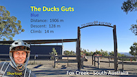
trail: The Ducks Guts
6:26 |
32 |
Mar 21, 2025
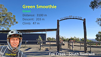
trail: Green Smoothie
5:55 |
105 |
Mar 21, 2025

trail: The Ducks Guts
6:26 |
45 |
Mar 21, 2025
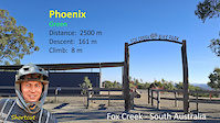
trail: Phoenix
5:33 |
149 |
Mar 21, 2025
Current Trail Warnings
| status | trail | date | condition | user | info |
|---|---|---|---|---|---|
| Northern DH Connector | Jun 7, 2026 @ 2:09pm (Australia/Adelaide) Jun 6, 2026 | Variable | jullzy | E-Bike |
Recent Trail Reports
| status | trail | date | condition | info | user |
|---|---|---|---|---|---|
| Futures and Options | Jun 29, 2026 @ 1:11pm (Australia/Adelaide) 2 days | Variable | PeterNvb2wu | ||
| Green Smoothie | Jun 27, 2026 @ 1:26pm (Australia/Adelaide) Jun 26, 2026 | Unknown | Damenearlymelba | ||
| Torture Hill Track | Jun 26, 2026 @ 2:01pm (Australia/Adelaide) Jun 25, 2026 | Ideal | lucascurlija | ||
| Venison | Jun 25, 2026 @ 1:53pm (Australia/Adelaide) Jun 24, 2026 | Wet | lucascurlija | ||
| B-Rad | Jun 20, 2026 @ 9:16am (Australia/Adelaide) Jun 19, 2026 | Wet | nogo12 | ||
| Allen's Orange Whip | Jun 20, 2026 @ 9:16am (Australia/Adelaide) Jun 19, 2026 | Wet | nogo12 | ||
| Chinamans Hut Track | Jun 13, 2026 @ 2:57pm (Australia/Adelaide) Jun 12, 2026 | Wet | MI6HTY | ||
| Chinamans Hut Track | Jun 13, 2026 @ 2:57pm (Australia/Adelaide) Jun 12, 2026 | Wet | MI6HTY | ||
| Steub Trail | Jun 13, 2026 @ 2:57pm (Australia/Adelaide) Jun 12, 2026 | Wet | MI6HTY | ||
| Haarsma's Vision | Jun 13, 2026 @ 9:10pm (Australia/Adelaide) Jun 13, 2026 | Prevalent Mud | rebfen |
Activity Feed
| username | action | type | title | date |
|---|---|---|---|---|
| seb0000 | ridden | trail | activity #98119114 | Jun 30, 2026 @ 4:12am 14 hours |
| saintal | ridden | trail | activity #98048491 and 2 more | Jun 29, 2026 @ 12:29am 2 days |
| PeterNvb2wu | add | report | activity #98042999 | Jun 28, 2026 @ 8:41pm 2 days |
| skyjogger | difficultyvote | trail | activity #98042942 | Jun 28, 2026 @ 8:39pm 2 days |
| JeffWt9Dh8 | wishlist | trail | activity #98040684 | Jun 28, 2026 @ 7:20pm 2 days |
Recent Comments
| username | type | title | comment | date |
|---|---|---|---|---|
| trail | Very muddy after rain in the morning | Jun 13, 2026 @ 4:36am Jun 13, 2026 | ||
| trail | When it’s wet, it’s wet | May 15, 2026 @ 8:43pm May 15, 2026 | ||
| trail | no you do | May 14, 2026 @ 8:07pm May 14, 2026 | ||
| trail | you suck | May 14, 2026 @ 8:07pm May 14, 2026 | ||
| trail | Closed until May 8th Forestry are shooting all... | May 3, 2026 @ 3:01am May 3, 2026 |
Local Badges
-

Completionist3 awarded -

10 Expert Trails81 awarded -
Completionist0 awarded -
Completionist3 awarded -
Completionist6 awarded -
Completionist24 awarded
Bike & Skill Parks
| name | type | city | rating |
|---|---|---|---|
| O'Halloran Hill | bike park | Adelaide | |
| Fox Creek Bike Park | bike park | Adelaide | |
| Apex Dirt Jumps Hawthorndene | skill park | Adelaide | |
| Eagle Mountain Skills Area | skill park | Adelaide | |
| Elliston Reserve | skill park | Adelaide |
Activity Type Stats
| activitytype | trails | distance | descent | descent distance | total vertical | rating | global rank | state rank | photos | reports | routes | ridelogs |
|---|---|---|---|---|---|---|---|---|---|---|---|---|
| Mountain Bike | 873 | 575 miles | 96,424 ft | 257 miles | 2,320 ft | #29 | #4 | 819 | 6,074 | 71 | 220,635 | |
| E-Bike | 506 | 394 miles | 62,247 ft | 179 miles | 2,320 ft | #37 | #26 | 2 | 5,120 | 40 | 21,887 | |
| Horse | 18 | 12 miles | 1,909 ft | 6 miles | 1,345 ft | #106 | #14 | 896 | ||||
| Hike | 804 | 572 miles | 85,285 ft | 240 miles | 2,339 ft | #27 | #5 | 21 | 5,562 | 11 | 4,911 | |
| Trail Running | 797 | 568 miles | 85,128 ft | 239 miles | 2,339 ft | #36 | #5 | 5,558 | 24 | 12,462 | ||
| Dirtbike/Moto | 9 | 37 miles | 1,178 ft | 15 miles | 1,040 ft | #94 | #4 | 887 | 9 | |||
| ATV/ORV/OHV | 30 | 62 miles | 5,295 ft | 27 miles | 1,243 ft | #30 | #4 | 887 | 12 | |||
| Snowmobile | 1 | 722 ft | 75 ft | #5 | 12 | |||||||
| Snowshoe | 1 | 722 ft | 75 ft | #5 | 14 | |||||||
| Downhill Ski | 1 | 722 ft | 75 ft | #5 | 12 | 4 | ||||||
| Backcountry Ski | 1 | 722 ft | 75 ft | #3 | 12 | |||||||
| Nordic Ski | 1 | 722 ft | 75 ft | #6 | 12 | 28 |
Frequently Asked Questions About Adelaide
▼
What are the best places to ride in Adelaide?
Adelaide has 37 areas to explore for mountain biking. The top rated areas are:
▼
What are the highest rated mountain biking trails in Adelaide?
The highest rated mountain biking trails in Adelaide are:
- Allen's Orange Whip (4.7/5)
- Blues Groove (4.7/5)
- Northern DH (4.6/5)
- Fox Fast (4.6/5)
- Short n Sweet (full trail) (4.5/5)
▼
What is the best time of the year to ride in Adelaide?
Based on ride log data, the most popular months to ride in Adelaide are:
- October (725 activities)
- December (713 activities)
- February (618 activities)
▼
Where can I park to ride in Adelaide?
There are 68 parking locations listed in Adelaide. The most popular parking spots are: View all parking and trailhead locations on the map to plan your visit.
Activities
Trails
Points of Interest
- By brenthillier
 NSMBA TRAILFORKS & contributors
 - Admins: NPSA, Coneofsilence, ForestrySA
- #8159 - 73,753 views
- adelaide activity log | embed map of Adelaide mountain bike trails | adelaide mountain biking points of interest
Downloading of trail gps tracks in kml & gpx formats is enabled for Adelaide.
You must login to download files.