close
-
Layers w
- Weather Layers
- Pro
- Pro
- Pro
- Pro
- Pro
- Pro
- More Layers
- Pro
- Pro
- Pro
- Pro
-
Upgrade to

3D
Trail Conditions
- Unknown
- Snow Groomed
- Snow Packed
- Snow Covered
- Snow Cover Partial
- Freeze/thaw Cycle
- Icy
- Prevalent Mud
- Wet
- Variable
- Ideal
- Dry
- Very Dry
Trail Flow (Ridden Direction)
Trailforks scans users ridelogs to determine the most popular direction each trail is ridden. A good flowing trail network will have most trails flowing in a single direction according to their intension.
The colour categories are based on what percentage of riders are riding a trail in its intended direction.
The colour categories are based on what percentage of riders are riding a trail in its intended direction.
- > 96%
- > 90%
- > 80%
- > 70%
- > 50%
- < 50%
- bi-directional trail
- no data
Trail Last Ridden
Trailforks scans ridelogs to determine the last time a trail was ridden.
- < 2 days
- < 1 week
- < 2 weeks
- < 1 month
- < 6 months
- > 6 months
Trail Ridden Direction
The intended direction a trail should be ridden.
- Downhill Only
- Downhill Primary
- Both Directions
- Uphill Primary
- Uphill Only
- One Direction
Contribute Details
Colors indicate trail is missing specified detail.
- Description
- Photos
- Description & Photos
- Videos
Trail Popularity ?
Trailforks scans ridelogs to determine which trails are ridden the most in the last 9 months.
Trails are compared with nearby trails in the same city region with a possible 25 colour shades.
Think of this as a heatmap, more rides = more kinetic energy = warmer colors.
- most popular
- popular
- less popular
- not popular
ATV/ORV/OHV Filter
Max Vehicle Width
inches
US Cell Coverage
Legend

Radar Time
Activity Recordings
Trailforks uses anonymized public activity data.
?
Activity Recordings
Trailforks uses anonymized public activity data.
?
Personal Heatmap
▶
Activity Types
all
/
none
▶
Options
2
Date range
month
–
Winter Trails
Warning
A routing network for winter maps does not exist. Selecting trails using the winter trails layer has been disabled.
Missing Trails
Most Popular
Least Popular
Trails are colored based on popularity. The more popular a trail is, the more red. Less popular trails trend towards green.
Jump Magnitude Heatmap
Heatmap of where riders jump on trails. Zoom in to see individual jumps, click circles to view jump details.
BC Backroad Status
![map legend]()
Service Road Atlas is a free to use, community-driven service for viewing and creating reports on the numerous back-country service roads around B.C. and Alberta.

Slope Aspect
Direction the slope faces
Trails Deemphasized
Trails are shown in grey.
Only show trails with no bike usage.
Suggested Layers
Based on selected activity type
Save the current map location and zoom level as your default home location whenever this page is loaded.
Save
No description for Airolo has been added yet!
Login or register to submit one.
This region uses the Uk/Euro style trail grading system.
Activities Click to view
- Mountain Bike
49 trails
- E-Bike
46 trails
- Gravel Bike
0 trails
- Hike
39 trails
- Trail Running
40 trails
Region Details
- 11
- 1
- 18
- 11
- 6
- 1
Region Status
Caution as of Oct 19, 2025Stats
- Avg Trail Rating
- Trails (view details)
- 48
- Trails Mountain Bike
- 49
- Trails E-Bike
- 46
- Trails Hike
- 40
- Trails Trail Running
- 40
- Total Distance
- 53 miles
- Total Descent Distance
- 36 miles
- Total Descent
- 24,540 ft
- Total Vertical
- 4,859 ft
- Highest Trailhead
- 8,617 ft
- Reports
- 137
- Photos
- 29
- Ridden Counter
- 1,895
Sub Regions
-
Airolo Bike Park
- 4
- 2
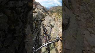
Popular Airolo Mountain Biking Trails
• 95 ★ 5.0 • 2,776 ft • 8 ft • 75 •
Popular blue difficulty alpine singletrack. This multi-use trail can be used downhill only and has a easy overall physical rating. Trail visibility is always easy to follow. On average it takes 8 minutes to complete this trail.
• 100 ★ 4.0 • 1,995 ft • 0 ft • 68 • • hike
Popular blue difficulty singletrack. This hike primary trail can be used downhill primary and has a moderate overall physical rating with a 0 ft blue climb. On average it takes 1 minutes to complete this trail.
• 90 ★ 4.5 • 2 miles • 7 ft • 22 •
The Pineta Trail starts at an altitude of 1850 metres above sea level, and winds through a spectacular alpine pine forest with panoramic views of the surrounding valley. This mountain bike trail starts in Pesciüm, which can be easily...
• 5 ★ 4.0 • 830 ft • 0 ft • 13 •
Less popular blue difficulty singletrack. This mountain bike primary trail can be used downhill only and has a moderate overall physical rating with a 0 ft blue climb. On average it takes minutes to complete this trail.
• 70 ★ 2.0 • 4,318 ft • 73 ft • 10 • • hike
Popular blue difficulty wilderness trail. This hike primary trail can be used downhill primary.
• 55 ★ 2.0 • 1 mile • 22 ft • 9 • • hike
Moderately popular blue difficulty singletrack. This hike primary trail can be used both directions.
• 55 ★ 0.0 • 3,668 ft • 58 ft • 9 •
Moderately popular red difficulty singletrack. This multi-use trail can be used downhill primary. On average it takes 5 minutes to complete this trail.
• 65 ★ 2.0 • 961 ft • 0 ft • 6 • • hike
Moderately popular blue difficulty singletrack. This hike primary trail.
Airolo Mountain Bike Routes
Airolo Bike #391 Featured
13 miles • 4,159 ft • 2 • Shuttled •
An itinerary rich in unique and unforgettable alpine walks and vistas, ideally suited to those who prefer...
20 miles • 4,891 ft • 2 • Loop •
Bel giro in alta montagna, lungo la famosa Tremola, la vecchia strada del passo del San Gottardo, con i...
★ 3.0 • 29 miles • 4,558 ft • 4 • Point to Point •
It is a trail for bikers who have good technical and physical preparation.
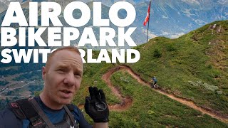
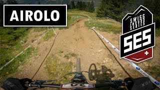
Photos of Airolo Mountain Bike
Videos of Airolo Mountain Bike
youtuber
![alpine playground]()
trail: Stabbiello
0:25 |
48 |
Sep 9, 2025 , Airolo
youtuber
![We had the Bikepark to ourselves! // All...]()
7:45 |
96 |
Sep 12, 2024
youtuber
![SES Airolo - Stage 1-3 / P16 Elite | Swiss...]()
15:12 |
175 |
Aug 4, 2024
youtuber
![SES Airolo Stage 3+4 | Swiss Enduro Series 2022]()

16:57 |
365 |
Aug 29, 2022
Recent Trail Reports
| status | trail | date | condition | info | user |
|---|---|---|---|---|---|
| Banchi Trail | Oct 19, 2025 @ 6:55pm (Europe/Zurich) Oct 19, 2025 | Variable | MG74 | ||
| Pascolo Bike l | Sep 29, 2025 @ 9:41am (Europe/Zurich) Sep 29, 2025 | Ideal | AiroloBikePark | ||
| Ravina Trail | Sep 29, 2025 @ 9:41am (Europe/Zurich) Sep 29, 2025 | Ideal | AiroloBikePark | ||
| Sasso Trail | Sep 29, 2025 @ 9:40am (Europe/Zurich) Sep 29, 2025 | Ideal | AiroloBikePark | ||
| Bosco Trail variante | Sep 29, 2025 @ 9:40am (Europe/Zurich) Sep 29, 2025 | Ideal | AiroloBikePark | ||
| Runcasc Trail | Sep 29, 2025 @ 9:40am (Europe/Zurich) Sep 29, 2025 | Ideal | AiroloBikePark | ||
| Bosco Trail | Sep 29, 2025 @ 9:39am (Europe/Zurich) Sep 29, 2025 | Ideal | AiroloBikePark | ||
| Gotthard San Carlo | Sep 8, 2025 @ 8:09am Sep 8, 2025 | Wet | blaze-j | ||
| Passo del San Gottardo | Sep 8, 2025 @ 8:09am Sep 8, 2025 | Ideal | blaze-j | ||
| Böcc da Ce | Sep 7, 2025 @ 10:13am Sep 7, 2025 | Ideal | trailpapst TRAILFORKS |
Activity Feed
| username | action | type | title | date |
|---|---|---|---|---|
| 8FIiHM | vote | route | activity #92585118 | Apr 14, 2026 @ 2:24am Apr 14, 2026 |
| Zulumatata | wishlist | trail | activity #85867186 | Dec 21, 2025 @ 2:06pm Dec 21, 2025 |
| koboldhh | wishlist | region | activity #82703727 | Oct 20, 2025 @ 5:22am Oct 20, 2025 |
| MG74 | add | report | activity #82660342 | Oct 19, 2025 @ 9:55am Oct 19, 2025 |
| ikroete | wishlist | region | activity #81726992 | Oct 4, 2025 @ 11:00pm Oct 4, 2025 |
Recent Comments
| username | type | title | comment | date |
|---|---|---|---|---|
| trail | Good connection, but not really interesting | Aug 13, 2025 @ 12:01pm Aug 13, 2025 | ||
| trail | Super single track, incredibly flowy and... | Aug 13, 2025 @ 12:00pm Aug 13, 2025 | ||
| trail | Scusami ma non avendo ricevuto la notifica da... | Jul 29, 2025 @ 12:05am Jul 29, 2025 | ||
| trail | Ciao, premetto non conosco la zona ma dalla... | Jul 1, 2025 @ 1:07pm Jul 1, 2025 | ||
| trail | Ciao, come si potrebbe fare quello che dici?... | Jul 1, 2025 @ 12:39pm Jul 1, 2025 |
Local Badges
-

Epic Mountain Bike Climb 2k9 awarded -

Climbing 10k Badge0 awarded -

Mountain Biking 100k Badge0 awarded -

Epic Ride Descent 2k9 awarded -

Descent 10k Badge0 awarded -

Descent 100k Badge0 awarded
Bike & Skill Parks
| name | type | city | rating |
|---|---|---|---|
| Airolo Bike Park | bike park | Airolo |
Activity Type Stats
| activitytype | trails | distance | descent | descent distance | total vertical | rating | global rank | state rank | photos | reports | routes | ridelogs |
|---|---|---|---|---|---|---|---|---|---|---|---|---|
| Mountain Bike | 49 | 53 miles | 24,541 ft | 36 miles | 4,859 ft | #2,939 | #41 | 29 | 138 | 3 | 1,238 | |
| E-Bike | 46 | 50 miles | 23,839 ft | 35 miles | 4,633 ft | #2,211 | #84 | 121 | 2 | 116 | ||
| Hike | 39 | 46 miles | 18,251 ft | 29 miles | 4,859 ft | #3,330 | #59 | 91 | 150 | |||
| Trail Running | 40 | 46 miles | 18,251 ft | 29 miles | 4,859 ft | #3,172 | #54 | 91 | 6 |
Frequently Asked Questions About Airolo
▼
What are the best places to ride in Airolo?
Airolo has 1 areas to explore for mountain biking. The top rated areas are:
▼
What are the highest rated mountain biking trails in Airolo?
The highest rated mountain biking trails in Airolo are:
- Bosco Trail (4.4/5)
- Bosco Trail variante (4.3/5)
- Sasso Trail (4.3/5)
- Runcasc Trail (4.3/5)
- Valdonia (4.1/5)
▼
What is the best time of the year to ride in Airolo?
Based on ride log data, the most popular months to ride in Airolo are:
- August (19 activities)
- July (15 activities)
- June (13 activities)
▼
Where can I park to ride in Airolo?
There are 1 parking locations listed in Airolo. The most popular parking spots are:
Activities
Trails
Points of Interest
- By picappa
 & contributors
 - Admins: TIS
- #37312 - 3,021 views
- airolo activity log | embed map of Airolo mountain bike trails | airolo mountain biking points of interest
Downloading of trail gps tracks in kml & gpx formats is enabled for Airolo.
You must login to download files.