close
-
Layers w
- Weather Layers
- Pro
- Pro
- Pro
- Pro
- Pro
- Pro
- More Layers
- Pro
- Pro
- Pro
- Pro
-
Upgrade to

3D
Trail Conditions
- Unknown
- Snow Groomed
- Snow Packed
- Snow Covered
- Snow Cover Partial
- Freeze/thaw Cycle
- Icy
- Prevalent Mud
- Wet
- Variable
- Ideal
- Dry
- Very Dry
Trail Flow (Ridden Direction)
Trailforks scans users ridelogs to determine the most popular direction each trail is ridden. A good flowing trail network will have most trails flowing in a single direction according to their intension.
The colour categories are based on what percentage of riders are riding a trail in its intended direction.
The colour categories are based on what percentage of riders are riding a trail in its intended direction.
- > 96%
- > 90%
- > 80%
- > 70%
- > 50%
- < 50%
- bi-directional trail
- no data
Trail Last Ridden
Trailforks scans ridelogs to determine the last time a trail was ridden.
- < 2 days
- < 1 week
- < 2 weeks
- < 1 month
- < 6 months
- > 6 months
Trail Ridden Direction
The intended direction a trail should be ridden.
- Downhill Only
- Downhill Primary
- Both Directions
- Uphill Primary
- Uphill Only
- One Direction
Contribute Details
Colors indicate trail is missing specified detail.
- Description
- Photos
- Description & Photos
- Videos
Trail Popularity ?
Trailforks scans ridelogs to determine which trails are ridden the most in the last 9 months.
Trails are compared with nearby trails in the same city region with a possible 25 colour shades.
Think of this as a heatmap, more rides = more kinetic energy = warmer colors.
- most popular
- popular
- less popular
- not popular
ATV/ORV/OHV Filter
Max Vehicle Width
inches
US Cell Coverage
Legend

Radar Time
Activity Recordings
Trailforks uses anonymized public activity data.
?
Activity Recordings
Trailforks uses anonymized public activity data.
?
Personal Heatmap
▶
Activity Types
all
/
none
▶
Options
2
Date range
month
–
Winter Trails
Warning
A routing network for winter maps does not exist. Selecting trails using the winter trails layer has been disabled.
Missing Trails
Most Popular
Least Popular
Trails are colored based on popularity. The more popular a trail is, the more red. Less popular trails trend towards green.
Jump Magnitude Heatmap
Heatmap of where riders jump on trails. Zoom in to see individual jumps, click circles to view jump details.
BC Backroad Status
![map legend]()
Service Road Atlas is a free to use, community-driven service for viewing and creating reports on the numerous back-country service roads around B.C. and Alberta.

Slope Aspect
Direction the slope faces
Trails Deemphasized
Trails are shown in grey.
Only show trails with no bike usage.
Suggested Layers
Based on selected activity type
Save the current map location and zoom level as your default home location whenever this page is loaded.
SaveThe Aja mountain range extends over an area of 100 kilometers to the northeastern side of the region and includes small villages and water sources
Primary Trail Type: Cross-Country
AKA: Aja, Tai
Land Status: City Managed
Access Info:
Al Mu'ayqilat
Disclaimer:
Trails are ridden at day only
Activities Click to view
- Mountain Bike
17 trails
- E-Bike
15 trails
- Horse
15 trails
- Hike
16 trails
- Trail Running
16 trails
- Dirtbike/Moto
15 trails
- ATV/ORV/OHV
15 trails
Region Details
- 6
- 1
- 5
- 5
Region Status
Open as of May 17, 2022Stats
- Avg Trail Rating
- Trails (view details)
- 17
- Trails Mountain Bike
- 17
- Trails E-Bike
- 15
- Trails Horse
- 15
- Trails Hike
- 16
- Trails Trail Running
- 16
- Trails Dirtbike/Moto
- 15
- Trails Observed Trials
- 3
- Trails ATV/ORV/OHV
- 15
- Total Distance
- 88 miles
- Total Descent Distance
- 44 miles
- Total Descent
- 3,527 ft
- Total Vertical
- 1,158 ft
- Highest Trailhead
- 4,245 ft
- Photos
- 6
- Ridden Counter
- 6
Popular Aja Mountains Mountain Biking Trails
• 5 ★ 0.0 • 22 miles • 614 ft • 1 •
Less popular blue difficulty mixed. This mountain bike primary trail can be used both directions.
• 5 ★ 5.0 • 4 miles • 612 ft • 1 •
Jaw Valley in Aja Mountain from Gethering Point to Lama aquifer.
• 5 ★ 5.0 • 1 mile • 221 ft • 1 •
Less popular blue difficulty singletrack. This mountain bike primary trail can be used both directions and has a moderate overall physical rating with a 221 ft black diamond climb. It features drop, rock face and rock garden. Trail visibility is always easy to follow.
• 5 ★ 5.0 • 16 miles • 990 ft • 1 •
Less popular blue difficulty primitive. This mountain bike primary trail can be used both directions and has a moderate overall physical rating with a 990 ft black diamond climb. Adaptive MTB rating: amtb blue. Trail visibility is always easy to follow.
• 5 ★ 5.0 • 5 miles • 93 ft • 1 •
Less popular green difficulty singletrack. This mountain bike primary trail can be used both directions. It features drop, rock face and rock garden.
• 5 ★ 5.0 • 5 miles • 355 ft •
Less popular blue difficulty doubletrack. This mountain bike primary trail can be used both directions and has a moderate overall physical rating with a 355 ft blue climb. It features drop, rock face and rock garden. Trail visibility is always easy to follow.
• 5 ★ 0.0 • 2 miles • 110 ft •
Less popular white difficulty sandy. This mountain bike primary trail can be used both directions.
• 5 ★ 0.0 • 8 miles • 452 ft •
Less popular green difficulty singletrack. This mountain bike primary trail can be used both directions and has a easy overall physical rating with a 452 ft green climb. Trail visibility is always easy to follow.
Videos of Aja Mountains Mountain Bike
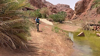
trail: Lama Base Trail
0:30 |
54 |
May 16, 2022

trail: Lama Base Trail
0:30 |
|
May 16, 2022
Activity Feed
| username | action | type | title | date |
|---|---|---|---|---|
| abunawafjr | add | trail | activity #74282797 and 3 more | Jun 21, 2025 @ 2:46pm Jun 21, 2025 |
| pjanicki74 | vote | trail | activity #39313416 and 2 more | Apr 23, 2023 @ 9:09pm Apr 23, 2023 |
| pjanicki74 | add | photo | activity #39313413 and 2 more | Apr 23, 2023 @ 9:09pm Apr 23, 2023 |
| pjanicki74 | comment | trail | activity #39313312 and 2 more | Apr 23, 2023 @ 9:02pm Apr 23, 2023 |
| abunawafjr | add | trail | activity #29423625 and 5 more | May 17, 2022 @ 1:36pm May 17, 2022 |
Recent Comments
| username | type | title | comment | date |
|---|---|---|---|---|
| trail | Visited in April 2023. Nice constant slope.... | Apr 23, 2023 @ 9:06pm Apr 23, 2023 | ||
| trail | Visited in April 2023. Not a good for MTB -... | Apr 23, 2023 @ 9:05pm Apr 23, 2023 | ||
| trail | Visited April 2023. Nice area, but a lot of... | Apr 23, 2023 @ 9:02pm Apr 23, 2023 |
Activity Type Stats
| activitytype | trails | distance | descent | descent distance | total vertical | rating | global rank | state rank | photos | reports | routes | ridelogs |
|---|---|---|---|---|---|---|---|---|---|---|---|---|
| Mountain Bike | 17 | 88 miles | 3,527 ft | 44 miles | 1,158 ft | #1,566 | #3 | 6 | 6 | |||
| E-Bike | 15 | 74 miles | 2,927 ft | 36 miles | 1,158 ft | #661 | #3 | 2 | ||||
| Horse | 15 | 74 miles | 2,927 ft | 36 miles | 1,158 ft | #79 | #1 | |||||
| Hike | 16 | 79 miles | 3,327 ft | 41 miles | 1,158 ft | #923 | #3 | |||||
| Trail Running | 16 | 79 miles | 3,327 ft | 41 miles | 1,158 ft | #466 | #3 | |||||
| Dirtbike/Moto | 15 | 74 miles | 2,927 ft | 36 miles | 1,158 ft | #101 | #1 | |||||
| Observed Trials | 3 | 4 miles | 266 ft | 1 mile | 394 ft | |||||||
| ATV/ORV/OHV | 15 | 74 miles | 2,927 ft | 36 miles | 1,158 ft | #37 | #1 |
Frequently Asked Questions About Aja Mountains
▼
What are the highest rated mountain biking trails in Aja Mountains?
The highest rated mountain biking trails in Aja Mountains are:
- Lama Base Trail (4.1/5)
- Al Qulaybain Loop (4.1/5)
- Qulaybain Branch (4.1/5)
- Al-Raeelah Base Trail (4.1/5)
- Shawshan Aquifer (4.1/5)
▼
Where can I park to ride in Aja Mountains?
Check the Aja Mountains trail map for trailhead and parking information. Community members regularly update access and parking details for trails in the area.
▼
What is the longest trail in Aja Mountains?
The longest trail in Aja Mountains is Al Qulaybain To Mawqaq at 21.5 miles. View all trails sorted by distance.
▼
How many trails are in Aja Mountains?
Aja Mountains has a total of 17 trails. Browse top mountain biking trails in Aja Mountains to find detailed information including difficulty ratings, distances, and trail conditions.
Activities
- aja mountains activity log | embed map of Aja Mountains mountain bike trails |
Downloading of trail gps tracks in kml & gpx formats is enabled for Aja Mountains.
You must login to download files.