close
-
Layers w
- Weather Layers
- Pro
- Pro
- Pro
- Pro
- Pro
- Pro
- More Layers
- Pro
- Pro
- Pro
- Pro
-
Upgrade to

3D
Trail Conditions
- Unknown
- Snow Groomed
- Snow Packed
- Snow Covered
- Snow Cover Partial
- Freeze/thaw Cycle
- Icy
- Prevalent Mud
- Wet
- Variable
- Ideal
- Dry
- Very Dry
Trail Flow (Ridden Direction)
Trailforks scans users ridelogs to determine the most popular direction each trail is ridden. A good flowing trail network will have most trails flowing in a single direction according to their intension.
The colour categories are based on what percentage of riders are riding a trail in its intended direction.
The colour categories are based on what percentage of riders are riding a trail in its intended direction.
- > 96%
- > 90%
- > 80%
- > 70%
- > 50%
- < 50%
- bi-directional trail
- no data
Trail Last Ridden
Trailforks scans ridelogs to determine the last time a trail was ridden.
- < 2 days
- < 1 week
- < 2 weeks
- < 1 month
- < 6 months
- > 6 months
Trail Ridden Direction
The intended direction a trail should be ridden.
- Downhill Only
- Downhill Primary
- Both Directions
- Uphill Primary
- Uphill Only
- One Direction
Contribute Details
Colors indicate trail is missing specified detail.
- Description
- Photos
- Description & Photos
- Videos
Trail Popularity ?
Trailforks scans ridelogs to determine which trails are ridden the most in the last 9 months.
Trails are compared with nearby trails in the same city region with a possible 25 colour shades.
Think of this as a heatmap, more rides = more kinetic energy = warmer colors.
- most popular
- popular
- less popular
- not popular
ATV/ORV/OHV Filter
Max Vehicle Width
inches
US Cell Coverage
Legend

Radar Time
Activity Recordings
Trailforks uses anonymized public activity data.
?
Activity Recordings
Trailforks uses anonymized public activity data.
?
Personal Heatmap
▶
Activity Types
all
/
none
▶
Options
2
Date range
month
–
Winter Trails
Warning
A routing network for winter maps does not exist. Selecting trails using the winter trails layer has been disabled.
Missing Trails
Most Popular
Least Popular
Trails are colored based on popularity. The more popular a trail is, the more red. Less popular trails trend towards green.
Jump Magnitude Heatmap
Heatmap of where riders jump on trails. Zoom in to see individual jumps, click circles to view jump details.
BC Backroad Status
![map legend]()
Service Road Atlas is a free to use, community-driven service for viewing and creating reports on the numerous back-country service roads around B.C. and Alberta.

Slope Aspect
Direction the slope faces
Trails Deemphasized
Trails are shown in grey.
Only show trails with no bike usage.
Suggested Layers
Based on selected activity type
Save the current map location and zoom level as your default home location whenever this page is loaded.
Save
No description for Alassio has been added yet!
Login or register to submit one.
This region uses the Uk/Euro style trail grading system.
Activities Click to view
- Mountain Bike
75 trails
- E-Bike
56 trails
- Gravel Bike
0 trails
- Adaptive Bike
0 trails
- Winter Fat Bike
0 trails
- Hike
73 trails
- Trail Running
74 trails
Region Details
- 7
- 6
- 20
- 23
Region Status
Open as of 1 dayStats
- Avg Trail Rating
- Trails (view details)
- 60
- Trails Mountain Bike
- 80
- Trails E-Bike
- 56
- Trails Horse
- 1
- Trails Hike
- 73
- Trails Trail Running
- 74
- Trails Dirtbike/Moto
- 1
- Total Distance
- 39 miles
- Total Descent
- 15,202 ft
- Total Vertical
- 1,920 ft
- Highest Trailhead
- 1,957 ft
- Reports
- 986
- Photos
- 109
- Ridden Counter
- 8,841
Sub Regions
-
Baia del Sole
- 6
- 7
- 15
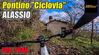
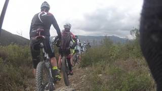
Popular Alassio Mountain Biking Trails
• 100 ★ 4.7 • 2,615 ft • 12 ft • 433 •
Popular green difficulty singletrack. This mountain bike primary trail can be used both directions and has a easy overall physical rating. On average it takes 4 minutes to complete this trail.
• 100 ★ 4.5 • 958 ft • 8 ft • 383 •
Popular green difficulty singletrack. This mountain bike primary trail can be used uphill only and has a easy overall physical rating with a 8 ft green climb. On average it takes 1 minutes to complete this trail.
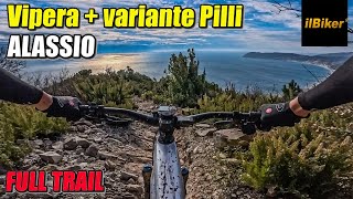
• 100 ★ 4.8 • 1 mile • 3 ft • 307 •
La nuova Vipera Prima parte del sentiero molto flow con fondo regolare e sponde e qualche piccolo drop. La parte centrale passa sull' iconico crinale caratterizzato da roccia fissa, diventa poi nuovamente flow con nuove curve lavorate e...
• 95 ★ 4.0 • 3,360 ft • 215 ft • 235 •
Popular green difficulty singletrack. This mountain bike primary trail and has a moderate overall physical rating with a 215 ft blue climb. On average it takes 15 minutes to complete this trail.
• 85 ★ 3.7 • 4,255 ft • 101 ft • 226 •
Mezza costa molto carino in gran parte in single track. La prima parte veloce su una gippabile poi diventa più variegato con alcuni rilanci su gradoni di roccia. Fattubile in tutte le stagioni.
• 90 ★ 4.0 • 3 miles • 253 ft • 219 •
Popular white difficulty mixed. This multi-use trail can be used both directions and has a easy overall physical rating. On average it takes 17 minutes to complete this trail.
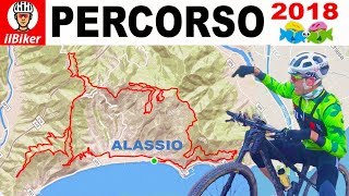
Alassio Mountain Bike Routes
★ 5.0 • 38 miles • 5,478 ft • 12 • Loop •
Partendo da Alassio, si risalgono 3 colline e si incontrano 9 sentieri. Si parte da Alassio, si sale dalla...
★ 4.0 • 27 miles • 3,802 ft • 4 • Loop •
Partenza da Alassio. Si percorre l'Aurelia fino ad Andora. Al semaforo girare a destra e salire da Rollo....
9 miles • 1,901 ft • 7 • Loop •
Partenza piazzetta del borgo antico di Solva Dopo una salita asfaltata lungo la strada panoramica Solva -...
10 miles • 1,965 ft • 8 • Loop •
Partenza Piazza S. Francesco Un primo tratto in asfalto porta alla Chiesa di Santa Croce. Da qui si...
6 miles • 1,576 ft • 4 • Loop •
Partenza Piazza Merlini del borgo antico di Moglio Il primo tratto di percorso - un misto molto ripido di...
15 miles • 2,302 ft • 6 • Loop •
Partenza da Alassio su asfalto in direzione Moglio. Si sale in zona Piscviavino e Madonna della Guardia....
Photos of Alassio Mountain Bike
Videos of Alassio Mountain Bike


Recent Trail Reports
Activity Feed
| username | action | type | title | date |
|---|---|---|---|---|
| Pardomap | add | report | activity #96739414 | Jun 11, 2026 @ 8:25am Jun 11, 2026 |
| Cuno67 | ridden | trail | activity #96526822 | Jun 8, 2026 @ 2:04am Jun 8, 2026 |
| MaximilianMI8hQz | ridden | trail | activity #95926633 | May 31, 2026 @ 4:43am May 31, 2026 |
| MaximilianMI8hQz | ridden | trail | activity #95926614 | May 31, 2026 @ 4:43am May 31, 2026 |
| MarcoUc0Bhl | wishlist | trail | activity #95728859 | May 28, 2026 @ 1:08pm May 28, 2026 |
Recent Comments
| username | type | title | comment | date |
|---|---|---|---|---|
| trail | ottimo fondo , terreno duro 🔝 | Apr 1, 2026 @ 1:05pm Apr 1, 2026 | ||
| trail | Peccato che la foto non corrisponde al... | Feb 20, 2026 @ 1:20pm Feb 20, 2026 | ||
| report | Dire che il vipera è un sentiero difficile (... | Jan 7, 2026 @ 11:01pm Jan 7, 2026 | ||
| trail | Tutta la linea è molto bella ottimo terreno | Nov 25, 2025 @ 12:32am Nov 25, 2025 | ||
| trail | Molto sporco scendendo da Poggio Bottaro. .... | Oct 14, 2025 @ 10:56pm Oct 14, 2025 |
Local Badges
-

10 Green Trails72 awarded -

10 Blue Trails44 awarded -

Epic Ride Climb 2k361 awarded -

Climbing 10k Badge43 awarded -

Climbing 100k Badge8 awarded -

Epic Ride Descent 2k369 awarded
Activity Type Stats
| activitytype | trails | distance | descent | descent distance | total vertical | rating | global rank | state rank | photos | reports | routes | ridelogs |
|---|---|---|---|---|---|---|---|---|---|---|---|---|
| Mountain Bike | 75 | 39 miles | 15,203 ft | 20 miles | 1,919 ft | #2,553 | #119 | 87 | 1,017 | 18 | 5,195 | |
| E-Bike | 56 | 21 miles | 7,060 ft | 11 miles | 1,909 ft | #1,648 | #172 | 27 | 981 | 1 | 986 | |
| Horse | 1 | 3 miles | 459 ft | 2 miles | 243 ft | 58 | ||||||
| Hike | 73 | 35 miles | 12,661 ft | 17 miles | 1,919 ft | #4,134 | #162 | 983 | 194 | |||
| Trail Running | 74 | 36 miles | 13,737 ft | 18 miles | 1,919 ft | #3,718 | #148 | 983 | 126 | |||
| Dirtbike/Moto | 1 | 56 |
Frequently Asked Questions About Alassio
▼
What are the best places to ride in Alassio?
Alassio has 1 areas to explore for mountain biking. The top rated areas are:
▼
What are the highest rated mountain biking trails in Alassio?
The highest rated mountain biking trails in Alassio are:
- Vipera (4.4/5)
- The Groove (4.3/5)
- Sentiero al Sole - 1a parte (4.2/5)
- Le Piastrelle (4.1/5)
- Moscai (4.1/5)
▼
What is the best time of the year to ride in Alassio?
Based on ride log data, the most popular months to ride in Alassio are:
- November (22 activities)
- May (12 activities)
- June (11 activities)
▼
Where can I park to ride in Alassio?
There are 1 parking locations listed in Alassio. The most popular parking spots are:
Activities
Trails
- By ragnobike
 & contributors
 - Admins: denitopia
- #4646 - 10,407 views
- alassio activity log | embed map of Alassio mountain bike trails | alassio mountain biking points of interest
Downloading of trail gps tracks in kml & gpx formats is enabled for Alassio.
You must login to download files.