close
-
Layers w
- Weather Layers
- Pro
- Pro
- Pro
- Pro
- Pro
- Pro
- More Layers
- Pro
- Pro
- Pro
- Pro
-
Upgrade to

3D
Trail Conditions
- Unknown
- Snow Groomed
- Snow Packed
- Snow Covered
- Snow Cover Partial
- Freeze/thaw Cycle
- Icy
- Prevalent Mud
- Wet
- Variable
- Ideal
- Dry
- Very Dry
Trail Flow (Ridden Direction)
Trailforks scans users ridelogs to determine the most popular direction each trail is ridden. A good flowing trail network will have most trails flowing in a single direction according to their intension.
The colour categories are based on what percentage of riders are riding a trail in its intended direction.
The colour categories are based on what percentage of riders are riding a trail in its intended direction.
- > 96%
- > 90%
- > 80%
- > 70%
- > 50%
- < 50%
- bi-directional trail
- no data
Trail Last Ridden
Trailforks scans ridelogs to determine the last time a trail was ridden.
- < 2 days
- < 1 week
- < 2 weeks
- < 1 month
- < 6 months
- > 6 months
Trail Ridden Direction
The intended direction a trail should be ridden.
- Downhill Only
- Downhill Primary
- Both Directions
- Uphill Primary
- Uphill Only
- One Direction
Contribute Details
Colors indicate trail is missing specified detail.
- Description
- Photos
- Description & Photos
- Videos
Trail Popularity ?
Trailforks scans ridelogs to determine which trails are ridden the most in the last 9 months.
Trails are compared with nearby trails in the same city region with a possible 25 colour shades.
Think of this as a heatmap, more rides = more kinetic energy = warmer colors.
- most popular
- popular
- less popular
- not popular
ATV/ORV/OHV Filter
Max Vehicle Width
inches
US Cell Coverage
Legend

Radar Time
Activity Recordings
Trailforks uses anonymized public activity data.
?
Activity Recordings
Trailforks uses anonymized public activity data.
?
Personal Heatmap
▶
Activity Types
all
/
none
▶
Options
2
Date range
month
–
Winter Trails
Warning
A routing network for winter maps does not exist. Selecting trails using the winter trails layer has been disabled.
Missing Trails
Most Popular
Least Popular
Trails are colored based on popularity. The more popular a trail is, the more red. Less popular trails trend towards green.
Jump Magnitude Heatmap
Heatmap of where riders jump on trails. Zoom in to see individual jumps, click circles to view jump details.
BC Backroad Status
![map legend]()
Service Road Atlas is a free to use, community-driven service for viewing and creating reports on the numerous back-country service roads around B.C. and Alberta.

Slope Aspect
Direction the slope faces
Trails Deemphasized
Trails are shown in grey.
Only show trails with no bike usage.
Suggested Layers
Based on selected activity type
Save the current map location and zoom level as your default home location whenever this page is loaded.
SaveAlbania, is a country in Southeast Europe on the Adriatic and Ionian Sea within the Mediterranean Sea. It shares land borders with Montenegro to the northwest, Kosovo to the northeast, North Macedonia to the east, Greece to the south and a maritime border with Italy to the west.is defined in an area of 28,748 square kilometres (11,100 square miles) and located on the Balkan Peninsula in South and Southeast Europe.[109] Its coastline faces the Adriatic Sea to the northwest and the Ionian Sea to the southwest within the Mediterranean Sea.
Region Details
- 240
- 69
- 135
- 312
- 22
Stats
- Avg Trail Rating
- Trails (view details)
- 974
- Trails Mountain Bike
- 792
- Trails E-Bike
- 818
- Trails Gravel Bike
- 1
- Trails Adaptive Bike
- 1
- Trails Horse
- 537
- Trails Hike
- 970
- Trails Trail Running
- 913
- Trails Dirtbike/Moto
- 256
- Trails Observed Trials
- 100
- Trails ATV/ORV/OHV
- 286
- Trails Snowmobile
- 15
- Trails Snowshoe
- 36
- Trails Downhill Ski
- 1
- Trails Backcountry Ski
- 1
- Total Distance
- 1,826 miles
- Total Descent
- 477,320 ft
- Total Vertical
- 7,742 ft
- Highest Trailhead
- 7,743 ft
- Reports
- 204
- Photos
- 5,967
- Ridden Counter
- 3,218
Sub Regions
- Alessio (12)
- Lezhë (12)
- Argirocastro (16)
- Gjirokaster (8)
- Lunxhëria (2)
- Mali i Gjerë (1)
- Këlcyrë (8)
- Gryka e Këlcyrës (8)
- Gjirokaster (8)
- Baldushk (0)
- Berat (6)
- Çorovoda (1)
- Çorovoda (1)
- Borsh (1)
- Coriza (0)
- Dardhë (0)
- Dibër (71)
- Diber (1)
- Durazzo (6)
- Elbasan (31)
- Fier (4)
- Gjirokastër (21)
- Korçë (31)
- Korça (31)
- Kukës (10)
- Bajram Curri (8)
- Bajram Curri (8)
- Lukovë (2)
- Piqeras (2)
- Scutari (49)
- Shishtavec (6)
- Vlora (80)
- Himare (40)
- Canyon of Gjipe (0)
- Kalaja e Himarës (0)
- Riviera (36)
- Sarandë (6)
- Blue Eye (1)
- Butrint National Park (4)
- vlore (35)
- Himare (40)
- Berat (7)
- Burrel (3)
- Durrësi (6)
- Erseke (1)
- Kavajë (7)
- Krujë (10)
- Kukës (10)
- Pogradec (36)
- Guri i Nikës Resource Reserve (1)
- Kalaja e Pogradecit (9)
- Lin (16)
- Tirana (381)
- Baldushk (19)
- Bërzhitë (0)
- Farkë (38)
- Grand Park of Tirana (29)
- Lalm (20)
- Ndroq (3)
- Petrelë (34)
- Pezë (15)
- Selita e Vogel (1)
- Shëngjergj (68)
- Vaqarr (40)
- Vora (2)
- Vorë (2)
- Mali i Buretos (0)
- The Karaburun-Sazan Marine Park (2)
- Thethi National Park (5)
- Ulza Regional Nature Park (0)
- Valbonë Valley National Park (1)
- Voskopojë (12)
- Zadrima (1)
- Zagoria National Park (1)
- Zall-Bastar (2)
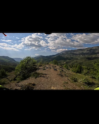
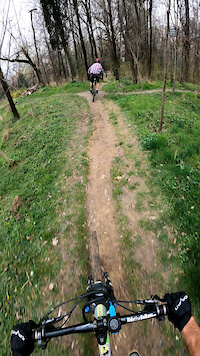
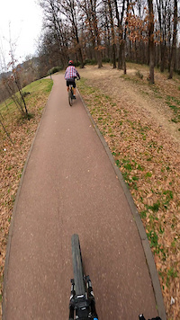
Popular Albania Mountain Biking Trails
• 100 ★ 2.0 • 1,319 ft • 0 ft • 41 •
Popular green difficulty singletrack. This mountain bike primary trail can be used both directions and has a moderate overall physical rating with a 0 ft green climb. It features berm. Trail visibility is always easy to follow. On average it takes 1 minutes to complete this trail.
• 95 ★ 3.4 • 4 miles • 332 ft • 19 •
Popular green difficulty doubletrack. This mountain bike primary trail can be used both directions and has a easy overall physical rating with a 332 ft green climb. It features berm. Trail visibility is always easy to follow. On average it takes 20 minutes to complete this trail.
• 100 ★ 2.0 • 2,572 ft • 98 ft • 14 •
Popular green difficulty family friendly singletrack. This mountain bike primary trail can be used both directions and has a easy overall physical rating with a 98 ft green climb. It features berm. Trail visibility is always easy to follow. On average it takes 1 minutes to complete this trail.
• 100 ★ 3.5 • 2,283 ft • 10 ft • 12 •
Popular green difficulty family friendly singletrack. This mountain bike primary trail can be used both directions and has a easy overall physical rating with a 10 ft green climb. It features berm. Trail visibility is always easy to follow. On average it takes 2 minutes to complete this trail.
• 80 ★ 4.7 • 3,491 ft • 5 ft • 12 •
Popular blue difficulty alpine singletrack. This mountain bike primary trail can be used downhill only and has a moderate overall physical rating with a 5 ft blue climb. It features berm, drop, jump and gap jump. Trail visibility is sometimes hard to follow. On average it takes 9 minutes to complete this trail.
• 80 ★ 0.0 • 1,706 ft • 122 ft • 12 •
Popular green difficulty singletrack. This multi-use trail can be used both directions and has a easy overall physical rating with a 122 ft blue climb. It features berm and rock garden. Trail visibility is no clear path. On average it takes minutes to complete this trail.
• 100 ★ 0.0 • 476 ft • 0 ft • 11 •
Popular white difficulty singletrack. This mountain bike primary trail can be used downhill primary and has a moderate overall physical rating with a 0 ft blue climb. Trail visibility is always easy to follow. On average it takes 2 minutes to complete this trail.
• 100 ★ 3.0 • 459 ft • 0 ft • 11 •
Popular blue difficulty singletrack. This mountain bike primary trail can be used downhill primary and has a moderate overall physical rating with a 0 ft blue climb. It features berm. Trail visibility is always easy to follow. On average it takes minutes to complete this trail.
Albania Mountain Bike Routes
★ 5.0 • 4,249 ft • 0 •
Epic descent from the main road heading towards Himare down to Dhermi beach ... if you like steep stairs...
★ 5.0 • 5 miles • 885 ft • 0 • Out & Back •
First trail route build from our guide Orgest and his mtb friends. Thought as an afternoon ride trail.
★ 5.0 • 1 mile • 37 ft • 0 • Out & Back •
Fast rocky descent towards beach. Can be climbed but better wear your bigboy pants.
19 miles • 3,528 ft • 0 • Point to Point •
Route starts from center of Verri and goes by the road to Guri i Bardhe. There you have the choice, go by...
6 miles • 952 ft • 0 • Loop •
First trail route build from our guide Orgest and his mtb friends. Thought as an afternoon ride trail.
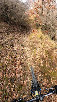
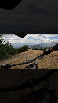
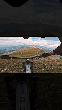
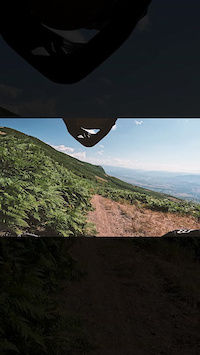
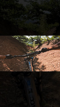
Photos of Albania Mountain Bike
Videos of Albania Mountain Bike
trail: Shutri Trail
0:18 |
2 |
Apr 29, 2026
trail: UNI trail 1
0:08 |
|
Mar 25, 2024
trail: Kurte Trail
0:10 |
|
Mar 25, 2024
trail: Korsia e Biçikletave
0:39 |
|
Mar 25, 2024
0:18 |
19 |
Aug 17, 2023
trail: Hinoskë - Maja e Velivarit
0:15 |
31 |
Aug 17, 2023
0:09 |
14 |
Aug 17, 2023
0:18 |
20 |
Aug 17, 2023
Recent Comments
| username | type | title | comment | date |
|---|---|---|---|---|
| trail | 3.6.2026 Marks (blue dots) in the first... | Jun 4, 2026 @ 2:44pm Jun 4, 2026 | ||
| trail | You can’t call it a mtb trail. Not... | Jun 4, 2026 @ 2:33pm Jun 4, 2026 | ||
| trail | Walked up the bottom to check it out. Looks... | May 20, 2026 @ 12:22pm May 20, 2026 | ||
| trail | Good to ride! Flowy! Probably also blue and... | May 20, 2026 @ 12:13pm May 20, 2026 | ||
| trail | Good to ride! Easy and flowy! | May 20, 2026 @ 12:11pm May 20, 2026 |
Activity Type Stats
| activitytype | trails | distance | descent | descent distance | total vertical | rating | global rank | state rank | photos | reports | routes | ridelogs |
|---|---|---|---|---|---|---|---|---|---|---|---|---|
| Mountain Bike | 790 | 1,533 miles | 374,951 ft | 734 miles | 7,569 ft | #35 | 5,981 | 196 | 16 | 8,643 | ||
| E-Bike | 818 | 1,581 miles | 401,568 ft | 759 miles | 7,569 ft | #27 | 181 | 2 | 227 | |||
| Gravel Bike | 1 | #44 | 12 | 52 | ||||||||
| Adaptive Bike | 1 | #42 | 2 | |||||||||
| Horse | 537 | 1,246 miles | 265,715 ft | 541 miles | 6,877 ft | #16 | 52 | |||||
| Hike | 962 | 1,706 miles | 452,290 ft | 800 miles | 7,743 ft | #26 | 16 | 198 | 3 | 2,206 | ||
| Trail Running | 913 | 1,696 miles | 441,562 ft | 806 miles | 7,743 ft | #28 | 197 | 2 | 428 | |||
| Dirtbike/Moto | 256 | 752 miles | 120,128 ft | 321 miles | 6,470 ft | #18 | 17 | 5 | ||||
| Observed Trials | 100 | 376 miles | 54,186 ft | 161 miles | 6,444 ft | #21 | 3 | |||||
| ATV/ORV/OHV | 286 | 866 miles | 121,480 ft | 340 miles | 6,877 ft | #17 | 19 | |||||
| Snowmobile | 15 | 61 miles | 12,631 ft | 25 miles | 6,394 ft | #27 | 3 | |||||
| Snowshoe | 36 | 58 miles | 15,843 ft | 24 miles | 6,142 ft | #41 | 5 | |||||
| Downhill Ski | 1 | 4,337 ft | 13 ft | 344 ft | 512 ft | #43 | 1 | 38 | ||||
| Backcountry Ski | 1 | #45 | 1 | 27 |
Activities
Trails
- By andiqyqja
 TRAILFORKS & contributors
 - Admins: andiqyqja
- #3272 - 42,421 views
- albania activity log | embed map of Albania mountain bike trails | albania mountain biking points of interest
Downloading of trail gps tracks in kml & gpx formats is enabled for Albania.
You must login to download files.