close
-
Layers w
- Weather Layers
- Pro
- Pro
- Pro
- Pro
- Pro
- Pro
- More Layers
- Pro
- Pro
- Pro
- Pro
-
Upgrade to

3D
Trail Conditions
- Unknown
- Snow Groomed
- Snow Packed
- Snow Covered
- Snow Cover Partial
- Freeze/thaw Cycle
- Icy
- Prevalent Mud
- Wet
- Variable
- Ideal
- Dry
- Very Dry
Trail Flow (Ridden Direction)
Trailforks scans users ridelogs to determine the most popular direction each trail is ridden. A good flowing trail network will have most trails flowing in a single direction according to their intension.
The colour categories are based on what percentage of riders are riding a trail in its intended direction.
The colour categories are based on what percentage of riders are riding a trail in its intended direction.
- > 96%
- > 90%
- > 80%
- > 70%
- > 50%
- < 50%
- bi-directional trail
- no data
Trail Last Ridden
Trailforks scans ridelogs to determine the last time a trail was ridden.
- < 2 days
- < 1 week
- < 2 weeks
- < 1 month
- < 6 months
- > 6 months
Trail Ridden Direction
The intended direction a trail should be ridden.
- Downhill Only
- Downhill Primary
- Both Directions
- Uphill Primary
- Uphill Only
- One Direction
Contribute Details
Colors indicate trail is missing specified detail.
- Description
- Photos
- Description & Photos
- Videos
Trail Popularity ?
Trailforks scans ridelogs to determine which trails are ridden the most in the last 9 months.
Trails are compared with nearby trails in the same city region with a possible 25 colour shades.
Think of this as a heatmap, more rides = more kinetic energy = warmer colors.
- most popular
- popular
- less popular
- not popular
ATV/ORV/OHV Filter
Max Vehicle Width
inches
US Cell Coverage
Legend

Radar Time
Activity Recordings
Trailforks uses anonymized public activity data.
?
Activity Recordings
Trailforks uses anonymized public activity data.
?
Personal Heatmap
▶
Activity Types
all
/
none
▶
Options
2
Date range
month
–
Winter Trails
Warning
A routing network for winter maps does not exist. Selecting trails using the winter trails layer has been disabled.
Missing Trails
Most Popular
Least Popular
Trails are colored based on popularity. The more popular a trail is, the more red. Less popular trails trend towards green.
Jump Magnitude Heatmap
Heatmap of where riders jump on trails. Zoom in to see individual jumps, click circles to view jump details.
BC Backroad Status
![map legend]()
Service Road Atlas is a free to use, community-driven service for viewing and creating reports on the numerous back-country service roads around B.C. and Alberta.

Slope Aspect
Direction the slope faces
Trails Deemphasized
Trails are shown in grey.
Only show trails with no bike usage.
Suggested Layers
Based on selected activity type
Save the current map location and zoom level as your default home location whenever this page is loaded.
Save
No description for Albavilla has been added yet!
Login or register to submit one.
This region uses the Uk/Euro style trail grading system.
Activities Click to view
- Mountain Bike
24 trails
- E-Bike
22 trails
- Horse
4 trails
- Hike
24 trails
- Trail Running
24 trails
- Snowshoe
0 trails
- Nordic Ski
0 trails
Region Details
- 2
- 1
- 5
- 4
Region Status
Open as of 21 hoursStats
- Avg Trail Rating
- Trails (view details)
- 13
- Trails Mountain Bike
- 24
- Trails E-Bike
- 22
- Trails Horse
- 4
- Trails Hike
- 24
- Trails Trail Running
- 24
- Total Distance
- 18 miles
- Total Descent
- 6,635 ft
- Total Vertical
- 2,931 ft
- Highest Trailhead
- 4,145 ft
- Reports
- 194
- Photos
- 22
- Ridden Counter
- 1,841
Popular Albavilla Mountain Biking Trails
• 90 ★ 4.4 • 1 mile • 313 ft • 134 •
Traverso nei boschi con qualche facile radice.
• 15 ★ 2.0 • 2 miles • 2 ft • 28 •
Partendo dall'Alpe del Vicerè, traccia inizialmente su rocciosi (fino alla Salute) poi più scorrevole e divertente. Qualche tratto gradinato nel bosco, poi mulattiera e scalinata (evitabile) in paese.
• 80 ★ 3.0 • 1,555 ft • 0 ft • 27 •
Popular green difficulty singletrack. This multi-use trail can be used both directions with a 0 ft green climb. Trail visibility is always easy to follow.
• 30 ★ 0.0 • 1,175 ft • 0 ft • 18 •
Facile singletrack naturale su terreno boschivo. Easy natural singletrack on forest terrain.
Albavilla Mountain Bike Routes
★ 4.7 • 13 miles • 3,631 ft • 2 • Point to Point •
Si sale alla Capanna Mara dallo evitando il più possible l'asfalto. La discesa ha un primo tratto in...
Photos of Albavilla Mountain Bike
Videos of Albavilla Mountain Bike
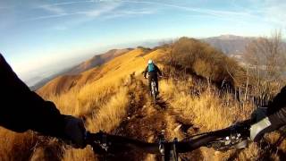
trail: Valle del Cosia
8:11 |
142 |
Nov 2, 2023 , Albavilla
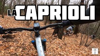
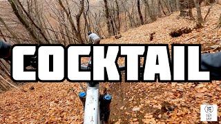
trail: Caprioli
2:57 |
188 |
Nov 2, 2023 , Albavilla

trail: Dosmat - Tri Fòò
36:55 |
247 |
Feb 11, 2023 , Albavilla
10:19 |
281 |
May 1, 2022 , Albavilla
Current Trail Warnings
| status | trail | date | condition | user | info |
|---|---|---|---|---|---|
| FunTrail Parte 2 | Jun 13, 2026 @ 8:20am (Europe/Rome) Jun 12, 2026 | Unknown | tomminonthebike2012 | Ho messo problema rilevante essendo che... |
Recent Trail Reports
| status | trail | date | condition | info | user |
|---|---|---|---|---|---|
| Dosmat - Tri Fòò | Jun 19, 2026 @ 12:12am (Pacific/Midway) 21 hours | Ideal | dadob | ||
| Traverso alla Patrizi | May 24, 2026 @ 8:13am (Europe/Rome) May 23, 2026 | Ideal | 31alex80 | ||
| Nisiate Trail | May 5, 2026 @ 7:21am (Europe/Rome) May 4, 2026 | Ideal | StefanoTWTOCw | ||
| FunTrail Parte 1 | Apr 11, 2026 @ 12:51pm (Europe/Vaduz) Apr 11, 2026 | Very Dry | FABIOSBIKE | ||
| Butiglia | Mar 29, 2026 @ 3:31pm (Europe/Rome) Mar 29, 2026 | Unknown | marionide | ||
| Caprioli | Mar 25, 2026 @ 11:21pm (Europe/Rome) Mar 25, 2026 | Variable | ilKasa | ||
| Alpe del Vicerè - Monte Bolettone | Mar 7, 2026 @ 12:11pm (Europe/Vaduz) Mar 7, 2026 | Ideal | FABIOSBIKE | ||
| Albavilla - Alpe del Viceré | Mar 7, 2026 @ 12:11pm (Europe/Vaduz) Mar 7, 2026 | Ideal | FABIOSBIKE | ||
| Sentiero degli Alpini | Feb 24, 2026 @ 11:09am (Europe/Rome) Feb 24, 2026 | Ideal | MatteoFrigerio | ||
| Valle del Cosia | Jan 4, 2026 @ 3:17pm (Europe/Rome) Jan 4, 2026 | Dry | larry81541 |
Activity Feed
| username | action | type | title | date |
|---|---|---|---|---|
| dadob | add | report | activity #97347128 | Jun 19, 2026 @ 3:03pm 10 hours |
| tomminonthebike2012 | add | report | activity #96850268 | Jun 12, 2026 @ 11:20pm Jun 12, 2026 |
| montfort | vote | trail | activity #96544221 | Jun 8, 2026 @ 9:15am Jun 8, 2026 |
| 31alex80 | add | report | activity #95407961 | May 24, 2026 @ 7:32am May 24, 2026 |
| Wildchild84 | wishlist | trail | activity #94793027 and 1 more | May 16, 2026 @ 12:35am May 16, 2026 |
Recent Comments
| username | type | title | comment | date |
|---|---|---|---|---|
| trail | mah, è sempre piuttosto sporco e comunque... | May 15, 2026 @ 1:56am May 15, 2026 | ||
| trail | non ne vale la pena | May 14, 2026 @ 7:03am May 14, 2026 | ||
| trail | Bello, attenzione ai pedoni | May 14, 2026 @ 7:02am May 14, 2026 | ||
| trail | Super panorama, fondo a tratti rotto ma si fa | May 14, 2026 @ 7:01am May 14, 2026 | ||
| trail | Facile, ma con un passaggio centrale non... | May 4, 2026 @ 10:05pm May 4, 2026 |
Local Badges
-

Epic Ride Climb 2k39 awarded -

Climbing 10k Badge21 awarded -

Climbing 100k Badge0 awarded -

Epic Ride Descent 2k39 awarded -

Descent 10k Badge20 awarded -

Descent 100k Badge0 awarded
Bike & Skill Parks
| name | type | city | rating |
|---|---|---|---|
| Bike Park Alpe del Vicerè | skill park | Albavilla |
Activity Type Stats
| activitytype | trails | distance | descent | descent distance | total vertical | rating | global rank | state rank | photos | reports | routes | ridelogs |
|---|---|---|---|---|---|---|---|---|---|---|---|---|
| Mountain Bike | 24 | 18 miles | 6,634 ft | 10 miles | 2,930 ft | #4,998 | #366 | 23 | 194 | 1 | 1,317 | |
| E-Bike | 22 | 15 miles | 5,909 ft | 8 miles | 2,759 ft | #885 | #112 | 177 | 272 | |||
| Horse | 4 | 5,115 ft | 1,066 ft | 5,115 ft | 1,066 ft | #1,805 | #102 | 40 | ||||
| Hike | 24 | 18 miles | 6,634 ft | 10 miles | 2,930 ft | #6,371 | #327 | 196 | 246 | |||
| Trail Running | 24 | 18 miles | 6,634 ft | 10 miles | 2,930 ft | #5,883 | #311 | 196 | 52 |
Frequently Asked Questions About Albavilla
▼
What are the highest rated mountain biking trails in Albavilla?
The highest rated mountain biking trails in Albavilla are:
- FunTrail Parte 1 (4.3/5)
- Traverso alla Patrizi (4.2/5)
- Bollettone - Bocchetta di Molina (4.1/5)
- Butiglia (4.1/5)
- Caprioli (4/5)
▼
What is the best time of the year to ride in Albavilla?
Based on ride log data, the most popular months to ride in Albavilla are:
- June (10 activities)
- May (9 activities)
- July (8 activities)
▼
Where can I park to ride in Albavilla?
There are 2 parking locations listed in Albavilla. The most popular parking spots are:
▼
What is the longest trail in Albavilla?
The longest trail in Albavilla is Brughiere: Parzano - Montorfano at 2.0 miles. View all trails sorted by distance.
Activities
Trails
Points of Interest
- By ivosavo & contributors
- Admins: marcoangeletti, adessoomaipiu, micheletraversi, NORTHNLINE, adessoomaipiu
- #21984 - 4,383 views
- albavilla activity log | embed map of Albavilla mountain bike trails | albavilla mountain biking points of interest
Downloading of trail gps tracks in kml & gpx formats is enabled for Albavilla.
You must login to download files.