close
-
Layers w
- Weather Layers
- Pro
- Pro
- Pro
- Pro
- Pro
- Pro
- More Layers
- Pro
- Pro
- Pro
- Pro
-
Upgrade to

3D
Trail Conditions
- Unknown
- Snow Groomed
- Snow Packed
- Snow Covered
- Snow Cover Partial
- Freeze/thaw Cycle
- Icy
- Prevalent Mud
- Wet
- Variable
- Ideal
- Dry
- Very Dry
Trail Flow (Ridden Direction)
Trailforks scans users ridelogs to determine the most popular direction each trail is ridden. A good flowing trail network will have most trails flowing in a single direction according to their intension.
The colour categories are based on what percentage of riders are riding a trail in its intended direction.
The colour categories are based on what percentage of riders are riding a trail in its intended direction.
- > 96%
- > 90%
- > 80%
- > 70%
- > 50%
- < 50%
- bi-directional trail
- no data
Trail Last Ridden
Trailforks scans ridelogs to determine the last time a trail was ridden.
- < 2 days
- < 1 week
- < 2 weeks
- < 1 month
- < 6 months
- > 6 months
Trail Ridden Direction
The intended direction a trail should be ridden.
- Downhill Only
- Downhill Primary
- Both Directions
- Uphill Primary
- Uphill Only
- One Direction
Contribute Details
Colors indicate trail is missing specified detail.
- Description
- Photos
- Description & Photos
- Videos
Trail Popularity ?
Trailforks scans ridelogs to determine which trails are ridden the most in the last 9 months.
Trails are compared with nearby trails in the same city region with a possible 25 colour shades.
Think of this as a heatmap, more rides = more kinetic energy = warmer colors.
- most popular
- popular
- less popular
- not popular
ATV/ORV/OHV Filter
Max Vehicle Width
inches
US Cell Coverage
Legend

Radar Time
Activity Recordings
Trailforks uses anonymized public activity data.
?
Activity Recordings
Trailforks uses anonymized public activity data.
?
Personal Heatmap
▶
Activity Types
all
/
none
▶
Options
2
Date range
month
–
Winter Trails
Warning
A routing network for winter maps does not exist. Selecting trails using the winter trails layer has been disabled.
Missing Trails
Most Popular
Least Popular
Trails are colored based on popularity. The more popular a trail is, the more red. Less popular trails trend towards green.
Jump Magnitude Heatmap
Heatmap of where riders jump on trails. Zoom in to see individual jumps, click circles to view jump details.
BC Backroad Status
![map legend]()
Service Road Atlas is a free to use, community-driven service for viewing and creating reports on the numerous back-country service roads around B.C. and Alberta.

Slope Aspect
Direction the slope faces
Trails Deemphasized
Trails are shown in grey.
Only show trails with no bike usage.
Suggested Layers
Based on selected activity type
Save the current map location and zoom level as your default home location whenever this page is loaded.
SaveYeah, we get it, we're not BC and we don't have as much terrain to work with but what we do have is a huge rider base and keen communities embracing bike culture. We're growing and tourism is following. What you'll find is an amazing diversity of trail types and styles from Hinton to Crowsnest Pass. From the insane amount of river valley trails in Edmonton to the jaw dropping vistas and historic trails of Jasper. Look around every community and you'll find something to ride, even if it's just the imagination of the kids dreaming big.
Region Details
- 1,129
- 417
- 1,967
- 1,966
- 477
- 47
- 3
Local Trail Association
Stats
- Avg Trail Rating
- Trails (view details)
- 9,024
- Trails Mountain Bike
- 6,079
- Trails E-Bike
- 3,638
- Trails Gravel Bike
- 588
- Trails Adaptive Bike
- 4
- Trails Winter Fat Bike
- 45
- Trails Horse
- 749
- Trails Hike
- 7,028
- Trails Trail Running
- 6,962
- Trails Dirtbike/Moto
- 710
- Trails Observed Trials
- 12
- Trails ATV/ORV/OHV
- 269
- Trails Snowmobile
- 51
- Trails Snowshoe
- 1,427
- Trails Downhill Ski
- 747
- Trails Backcountry Ski
- 412
- Trails Nordic Ski
- 778
- Total Distance
- 8,677 miles
- Total Descent
- 1,248,136 ft
- Total Vertical
- 11,423 ft
- Highest Trailhead
- 11,427 ft
- Reports
- 96,174
- Photos
- 21,657
- Ridden Counter
- 1,755,615
Articles
Video: Self-Shot Hot Laps on Some Of Alberta's Finest in 'Moosen'
May 28, 2026 from pinkbike.com
Bow Cycle's media creator takes a tripod and a custom Giant Reign Advanced E+2 out to Alberta's premium network to stack high-speed solo clips.
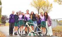
How the Canmore Women’s Enduro Turned a Local Race Into a Community Movement
Dec 2, 2025 from pinkbike.com
What began as an inclusive local enduro has grown into Peak Pursuits, one of Canada’s fastest-growing all-female cycling teams.
Race Report: Bee's Knees Enduro 2025 - Crowsnest Pass, AB
Sep 17, 2025 from pinkbike.com
Over 250 racers converged on the Pass Powderkeg Trail system for the 3rd annual Bee's Knees Enduro presented by United Riders of Crowsnest (UROC).
Race Report: Dust, Taquitos & A Whole Lot of Heart at MooseDuro 2025
Sep 15, 2025 from pinkbike.com
Rocky trails, great vibes, and a whole lot of two-wheel fun capped off another epic event.
Popular Trail Networks
view all areas »Sub Regions
- Alberta's Rockies (136)
- Calgary Metropolitan Region (1,468)
- Foothills County (86)
- Rocky View County (88)
- Wheatland County (CMR) (1)
- Central Alberta (1,101)
- Beaver County (11)
- Brazeau County (40)
- Camrose County (22)
- Clearwater County (217)
- County of Vermilion River (21)
- Improvement District No. 13 (2)
- Lacombe County (27)
- Minburn County (4)
- Mountain View County (155)
- Municipal District of Bonnyville (21)
- Red Deer County (136)
- Stettler County (6)
- Yellowhead County (279)
- Edmonton Metropolitan Region (1,405)
- Edmonton (1,024)
- Leduc County (197)
- Parkland County (94)
- Strathcona County (115)
- Sturgeon County (31)
- Jasper Municipality (184)
- Kananaskis Country (581)
- Bow Valley (324)
- Elbow Valley (209)
- Peter Lougheed (1)
- Northern Alberta (576)
- Southern Alberta (772)
- County of Newell (4)
- Cypress County (222)
- Improvement District No. 04 (Waterton) (19)
- Kneehill County (4)
- Lethbridge County (188)
- Municipal District of Pincher Creek (29)
- Municipal District of Ranchland (8)
- Municipal District of Taber (57)
- Municipal District of Willow Creek (2)
- Municipality of Crowsnest Pass (180)
- Warner County (1)
- Wheatland County (8)
Popular Alberta Mountain Biking Trails
• 100 ★ 4.4 • 2 miles • 532 ft • 4,601 •
is a fun bit of singletrack that leads out to connections with the south end of , and , , . It's a full bench cut that twists and turns all the way out to the junction with Merlin. The climbs and descents are very much like all the...
• 100 ★ 4.5 • 4 miles • 628 ft • 4,454 •
Built in 2014, followed the successful build of the previous year and it shares the same trademark features: consistent grades for easier climbing and flowing descents, sweeping bermed corners, rollers, bumps & table-tops. It has...
• 100 ★ 4.0 • 3 miles • 948 ft • 3,471 •
Starts from the WBC South Bridge trailhead and climbs all the way up to the / junction. Along the way, you cross , and trails and the junction. At the 3.6km mark, there is a short spur to a great viewpoint. At the start of the trail...
• 100 ★ 4.5 • 2 miles • 249 ft • 3,461 •
A great new trail that climbs up from the meadow to the top of T2 (providing an additional access to that area). The downtrack is buff and well bermed. Good in winter as well
• 100 ★ 4.1 • 2,225 ft • 38 ft • 3,357 •
A short, fun connector trail from and George Town Interpretive to the Canmore Trail. It flows well in both directions and features a couple of wide, low bridges and a short section of baby head rocks.
• 100 ★ 4.2 • 2 miles • 65 ft • 3,282 •
Continues along the ridge top to the popular viewpoint shown on the map. It then descends and climbs up to another summit and the junction. It then continues down to the junction, crosses and ski trails and ends at the junction. - - is...
Alberta Mountain Bike Routes
Prairie View to Jewell Pass Loop Featured
★ 4.4 • 10 miles • 2,053 ft • 2 • Loop •
An oldie but a goodie! The PV-JP Loop has been a mainstay of the local riding scene since the '90s. This...
★ 5.0 • 10 miles • 1,432 ft • 5 • Loop •
, and create the new 'Jumped Up Loops'. This figure-eight is the suggested way to get maximum...
★ 5.0 • 9 miles • 1,138 ft • 4 • Loop •
This route takes in the two core Jumped Up Loop trails in the shortest / fastest possible loop.
Big climbs and cross country rides Featured
9 miles • 1,002 ft • 4 • Loop •
The ride this week is a little tougher than the last couple routes that have been posted. It starts off at...
5 miles • 665 ft • 10 •
A green campground loop that starts at the Visitor Centre and finishes off on a downhill blue on Old...
YEG Epic Featured
25 miles • 1,721 ft • 0 • Point to Point •
Traverse Edmonton from the furthest SW point to the furthest NE point on singletrack! Terwillegar to Sunridge.
Photos of Alberta Mountain Bike
Videos of Alberta Mountain Bike
featured
![Beaver Bike Fest 2015]()
trail: Flow Master
2:17 |
1874 |
Aug 30, 2015
trail: McKenzie Trails Bench Trail
0:23 |
|
Jun 16, 2026
trail: Justice Training Loop
0:32 |
|
Jun 13, 2026
trail: Castledown Humps
2:01 |
8 |
Jun 7, 2026
trail: Mustang Rewind
0:39 |
13 |
Jun 3, 2026
trail: Cowboy
3:08 |
25 |
May 31, 2026
trail: Rolling the Coal
0:07 |
7 |
May 17, 2026
trail: Twist and Shout
0:36 |
13 |
May 3, 2026
National Scenic Trails & Official Routes
-
Continental Divide Trail
- Mountain Bike
- Hike
- Trail Running
-
Pacific Northwest Trail
- Mountain Bike
- Horse
- Hike
- Trail Running

Activity Feed
| username | action | type | title | date |
|---|---|---|---|---|
| yaross | wishlist | trail | activity #97264730 | Jun 18, 2026 @ 11:17am 2 hours |
| newbikerincon | add | report | activity #97259085 | Jun 18, 2026 @ 9:51am 3 hours |
| Luke8ar61u | ridden | trail | activity #97254888 | Jun 18, 2026 @ 8:43am 4 hours |
| Bcharanduk | add | report | activity #97252403 | Jun 18, 2026 @ 7:59am 5 hours |
| Bcharanduk | add | report | activity #97252402 | Jun 18, 2026 @ 7:59am 5 hours |
Recent Comments
| username | type | title | comment | date |
|---|---|---|---|---|
| trail | it's just one rock roll/drop but it's fun for... | Jun 17, 2026 @ 8:28pm 16 hours | ||
| trail | Just a damn great trail. | Jun 16, 2026 @ 5:56am 2 days | ||
| trail | Borderline double black in spots for sure... | Jun 16, 2026 @ 5:55am 2 days | ||
| trail | If anyone finds a pair of prescription glasses... | Jun 14, 2026 @ 6:15pm Jun 14, 2026 | ||
| trail | This as well as Wont Die has been blocked off... | Jun 12, 2026 @ 2:59pm Jun 12, 2026 |
Local Badges
-

10 Green Trails195 awarded -

Top 10 Trails33 awarded -

10 Blue Trails305 awarded -
10 Green Trails27 awarded -
10 Blue Trails32 awarded -

Epic Ride Climb 2k187 awarded
Bike & Skill Parks
| name | type | city | rating |
|---|---|---|---|
| Winsport Bike Park | bike park | Calgary | |
| Nitehawk Bike Park | bike park | Grande Prairie | |
| Park Allen Pump Track | skill park | ||
| Strathcona County Bike Skills Park | skill park | Sherwood Park | |
| Riverview Bike Park | skill park | Devon |
Upcoming Local Events
Activity Type Stats
| activitytype | trails | distance | descent | descent distance | total vertical | rating | global rank | state rank | photos | reports | routes | ridelogs |
|---|---|---|---|---|---|---|---|---|---|---|---|---|
| Mountain Bike | 6,079 | 4,721 miles | 526,490 ft | 1,882 miles | 10,016 ft | #9 | 20,081 | 93,960 | 832 | 1,294,295 | ||
| E-Bike | 3,638 | 3,084 miles | 383,894 ft | 1,251 miles | 8,202 ft | #11 | 146 | 79,854 | 148 | 47,643 | ||
| Gravel Bike | 588 | 661 miles | 48,904 ft | 229 miles | 6,975 ft | #18 | 74 | 11,609 | 58 | 6,607 | ||
| Adaptive Bike | 4 | #26 | 9 | 91 | 78 | |||||||
| Winter Fat Bike | 45 | #19 | 44 | 679 | 52 | 1,072 | ||||||
| Horse | 749 | 1,602 miles | 164,121 ft | 610 miles | 7,546 ft | #17 | 11 | 21,796 | 13 | 317 | ||
| Hike | 7,028 | 6,836 miles | 796,578 ft | 2,429 miles | 11,424 ft | #16 | 904 | 92,372 | 111 | 104,183 | ||
| Trail Running | 6,962 | 6,714 miles | 778,107 ft | 2,390 miles | 11,424 ft | #15 | 61 | 92,401 | 166 | 174,429 | ||
| Dirtbike/Moto | 710 | 1,119 miles | 148,888 ft | 500 miles | 7,556 ft | #10 | 103 | 22,316 | 9 | 7,980 | ||
| Observed Trials | 12 | 17 miles | 1,385 ft | 5 miles | 6,030 ft | #14 | 8 | 139 | 223 | |||
| ATV/ORV/OHV | 269 | 552 miles | 56,959 ft | 239 miles | 7,320 ft | #13 | 17 | 21,190 | 2 | 993 | ||
| Snowmobile | 51 | 101 miles | 7,474 ft | 35 miles | 5,433 ft | #15 | 2 | 3,002 | 164 | |||
| Snowshoe | 1,427 | 1,796 miles | 213,530 ft | 556 miles | 11,332 ft | #10 | 4 | 6,439 | 28 | 2,827 | ||
| Downhill Ski | 747 | 259 miles | 216,555 ft | 217 miles | 6,716 ft | #12 | 33 | 1,958 | 36,485 | |||
| Backcountry Ski | 412 | 759 miles | 83,953 ft | 212 miles | 11,332 ft | #8 | 9 | 1,142 | 10 | 16,432 | ||
| Nordic Ski | 778 | 806 miles | 57,024 ft | 296 miles | 10,164 ft | #9 | 116 | 2,752 | 18 | 50,531 |
Activities
- Alberta Mountain Biking Trails
- Alberta E-Biking Trails
- Alberta Gravel Biking Trails
- Alberta Winter Fat Biking Trails
- Alberta Horseback Trails
- Alberta Hiking Trails
- Alberta Trail Running Trails
- Alberta Dirtbiking Trails
- Alberta Observed Trials Trails
- Alberta ATVing/Offroading Trails
- Alberta Snowmobiling Trails
- Alberta Snowshoeing Trails
- Alberta Skiing Trails
- Alberta Backcountry Skiing Trails
- Alberta Nordic Skiing Trails
Trails
Points of Interest
- Museum Drop TTF
- The Red Cliff Viewpoint
- Tom Trott Forestry Museum Sight
- Lake Viewpoint
- Horseshoe Canyon Viewpoint
- Interpretive Center Information
- Edmonton Hoodoos TTF
- McNalley Dirt Jumps TTF
- EZ View Point Viewpoint
- Jarvis Lake Viewpoint
- North Twin Peak (11,946 ft)
- Mount Alberta (11,624 ft)
- Mount Forbes (11,594 ft)
- By radek
 Trailforks SDBA & contributors
 - Admins: IMBA Canada, brenthillier, adaptivemike, maddy03, AEF, Canadmos, warrenmacdonald
- #3088 - 160,454 views
- alberta activity log | embed map of Alberta mountain bike trails | alberta mountain biking points of interest polygons
Downloading of trail gps tracks in kml & gpx formats is enabled for Alberta.
You must login to download files.