close
-
Layers w
- Weather Layers
- Pro
- Pro
- Pro
- Pro
- Pro
- Pro
- More Layers
- Pro
- Pro
- Pro
- Pro
-
Upgrade to

3D
Trail Conditions
- Unknown
- Snow Groomed
- Snow Packed
- Snow Covered
- Snow Cover Partial
- Freeze/thaw Cycle
- Icy
- Prevalent Mud
- Wet
- Variable
- Ideal
- Dry
- Very Dry
Trail Flow (Ridden Direction)
Trailforks scans users ridelogs to determine the most popular direction each trail is ridden. A good flowing trail network will have most trails flowing in a single direction according to their intension.
The colour categories are based on what percentage of riders are riding a trail in its intended direction.
The colour categories are based on what percentage of riders are riding a trail in its intended direction.
- > 96%
- > 90%
- > 80%
- > 70%
- > 50%
- < 50%
- bi-directional trail
- no data
Trail Last Ridden
Trailforks scans ridelogs to determine the last time a trail was ridden.
- < 2 days
- < 1 week
- < 2 weeks
- < 1 month
- < 6 months
- > 6 months
Trail Ridden Direction
The intended direction a trail should be ridden.
- Downhill Only
- Downhill Primary
- Both Directions
- Uphill Primary
- Uphill Only
- One Direction
Contribute Details
Colors indicate trail is missing specified detail.
- Description
- Photos
- Description & Photos
- Videos
Trail Popularity ?
Trailforks scans ridelogs to determine which trails are ridden the most in the last 9 months.
Trails are compared with nearby trails in the same city region with a possible 25 colour shades.
Think of this as a heatmap, more rides = more kinetic energy = warmer colors.
- most popular
- popular
- less popular
- not popular
ATV/ORV/OHV Filter
Max Vehicle Width
inches
US Cell Coverage
Legend

Radar Time
Activity Recordings
Trailforks uses anonymized public activity data.
?
Activity Recordings
Trailforks uses anonymized public activity data.
?
Personal Heatmap
▶
Activity Types
all
/
none
▶
Options
2
Date range
month
–
Winter Trails
Warning
A routing network for winter maps does not exist. Selecting trails using the winter trails layer has been disabled.
Missing Trails
Most Popular
Least Popular
Trails are colored based on popularity. The more popular a trail is, the more red. Less popular trails trend towards green.
Jump Magnitude Heatmap
Heatmap of where riders jump on trails. Zoom in to see individual jumps, click circles to view jump details.
BC Backroad Status
![map legend]()
Service Road Atlas is a free to use, community-driven service for viewing and creating reports on the numerous back-country service roads around B.C. and Alberta.

Slope Aspect
Direction the slope faces
Trails Deemphasized
Trails are shown in grey.
Only show trails with no bike usage.
Suggested Layers
Based on selected activity type
Save the current map location and zoom level as your default home location whenever this page is loaded.
Save
No description for Almendrales has been added yet!
Login or register to submit one.
 google parking directions
Primary Trail Type: Cross-Country
eBikes Allowed:
Yes
Shuttleable: YES
google parking directionsThis region uses the Uk/Euro style trail grading system.
Activities Click to view
- Mountain Bike
110 trails
- E-Bike
110 trails
- Horse
5 trails
- Hike
109 trails
- Trail Running
107 trails
Region Details
- 26
- 10
- 36
- 18
Region Status
Caution as of Jun 1, 2026Stats
- Avg Trail Rating
- Trails (view details)
- 90
- Trails Mountain Bike
- 110
- Trails E-Bike
- 110
- Trails Horse
- 5
- Trails Hike
- 109
- Trails Trail Running
- 107
- Total Distance
- 45 miles
- Total Descent
- 15,839 ft
- Total Vertical
- 1,973 ft
- Highest Trailhead
- 2,024 ft
- Reports
- 627
- Photos
- 222
- Ridden Counter
- 7,901
Popular Almendrales Mountain Biking Trails
• 100 ★ 4.7 • 1,781 ft • 0 ft • 298 •
Highly rated popular blue difficulty singletrack. This multi-use trail can be used downhill primary and has a moderate overall physical rating with a 0 ft blue climb. It features berm, jump and roller coaster. On average it takes 2 minutes to complete this trail.
• 95 ★ 4.1 • 2,612 ft • 0 ft • 280 •
Highly rated popular blue difficulty singletrack. This multi-use trail can be used downhill primary and has a moderate overall physical rating. On average it takes 5 minutes to complete this trail.
• 100 ★ 4.0 • 1,706 ft • 0 ft • 253 •
Popular green difficulty singletrack. This multi-use trail can be used both directions and has a easy overall physical rating. On average it takes 2 minutes to complete this trail.
• 100 ★ 5.0 • 2,100 ft • 0 ft • 193 •
Popular blue difficulty singletrack. This multi-use trail can be used downhill primary and has a moderate overall physical rating with a 0 ft blue climb. It features berm, jump, pump track and rock garden. Trail visibility is always easy to follow. On average it takes 2 minutes to complete this trail.
• 100 ★ 5.0 • 1,001 ft • 0 ft • 175 •
Popular blue difficulty singletrack. This multi-use trail can be used downhill primary and has a moderate overall physical rating with a 0 ft blue climb. Trail visibility is always easy to follow. On average it takes minutes to complete this trail.
Almendrales Mountain Bike Routes
★ 5.0 • 16 miles • 3,379 ft • 16 • Loop •
Route that links main trails in Alemdrales area in Malaga region
★ 3.0 • 16 miles • 3,379 ft • 16 • Loop •
A series of loops on Almendrales area, with 5 nice down sections and not so bad climbing through access roads.
• 1 mile • 11 ft • 1 •
• 11 miles • 3,042 ft • 24 •
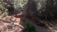
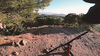
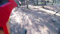
Photos of Almendrales Mountain Bike
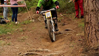
Videos of Almendrales Mountain Bike
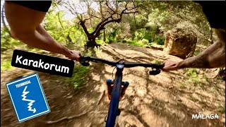
trail: Karakorum
0:07 |
|
Dec 15, 2021
trail: Karakorum
3:20 |
394 |
Jan 17, 2018
trail: Dual Almendrales
0:44 |
256 |
Jan 30, 2017
trail: Zabala
5:55 |
2092 |
Sep 18, 2013
youtuber
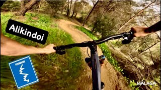
![Alikindoi | Blue trail | Málaga mountains - Spain]()

trail: Alternativa Alikindoi
3:32 |
62 |
Apr 2, 2026 , Málaga
youtuber
![Alikindoi | Blue trail | Málaga mountains - Spain]()
trail: Alikindoi parte alta
3:32 |
80 |
Apr 2, 2026 , Málaga
youtuber
![Antimasakra | Single Black trail | Málaga...]()
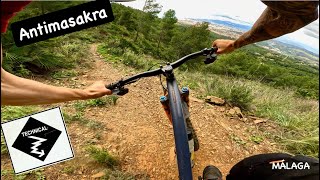
trail: Antimasakra
0:52 |
74 |
Apr 1, 2026 , Málaga
Current Trail Warnings
| status | trail | date | condition | user | info |
|---|---|---|---|---|---|
| Adam 2 | May 24, 2026 @ 1:28pm (Europe/Madrid) May 24, 2026 | Very Dry | Sergio7F | árbol caído justo en el camino, hay un... |
Recent Trail Reports
| status | trail | date | condition | info | user |
|---|---|---|---|---|---|
| Kawasaki | Jun 1, 2026 @ 12:17pm (Europe/Madrid) Jun 1, 2026 | Dry | Sergio7F | ||
| Pastor | May 29, 2026 @ 8:22pm (Europe/Madrid) May 29, 2026 | Dry | Gonzalobr2006 | ||
| Conexión Pastor New | May 29, 2026 @ 8:20pm (Europe/Madrid) May 29, 2026 | Dry | Gonzalobr2006 | ||
| Casa Rota | May 21, 2026 @ 4:12pm (Europe/Madrid) May 21, 2026 | Dry | Gonzalobr2006 | ||
| Alikindoi parte alta | May 11, 2026 @ 8:46pm (Europe/Madrid) May 11, 2026 | Dry | Gonzalobr2006 | ||
| miniKalasnikov | May 11, 2026 @ 8:44pm (Europe/Madrid) May 11, 2026 | Dry | Gonzalobr2006 | ||
| Tuliki | May 11, 2026 @ 8:43pm (Europe/Madrid) May 11, 2026 | Dry | Gonzalobr2006 | ||
| Tuliki | May 11, 2026 @ 8:43pm (Europe/Madrid) May 11, 2026 | Dry | Gonzalobr2006 | ||
| Variante | May 9, 2026 @ 6:29pm (Europe/Madrid) May 9, 2026 | Variable | Gonzalobr2006 | ||
| Karakorum | May 7, 2026 @ 7:04pm (Europe/Madrid) May 7, 2026 | Dry | Gonzalobr2006 |
Activity Feed
| username | action | type | title | date |
|---|---|---|---|---|
| Sergio7F | add | report | activity #96006320 | Jun 1, 2026 @ 3:18am Jun 1, 2026 |
| Gonzalobr2006 | add | report | activity #95791064 and 1 more | May 29, 2026 @ 11:20am May 29, 2026 |
| GrgoirekUUDfO | ridden | trail | activity #95640021 | May 27, 2026 @ 9:28am May 27, 2026 |
| Sergio7F | add | report | activity #95395471 | May 24, 2026 @ 4:28am May 24, 2026 |
| Gonzalobr2006 | add | report | activity #95172987 | May 21, 2026 @ 7:13am May 21, 2026 |
Recent Comments
| username | type | title | comment | date |
|---|---|---|---|---|
| trail | El tramo inicial es difícil debido a la... | Mar 1, 2026 @ 12:49pm Mar 1, 2026 | ||
| report | Árbol caído bloqueando el paso al comienzo... | Feb 17, 2026 @ 10:17am Feb 17, 2026 | ||
| trail | Couple of fallen tres on the Trail atm… | Jan 15, 2026 @ 4:34am Jan 15, 2026 | ||
| trail | Top is gravel-shit, better take the other on.... | Jan 6, 2026 @ 8:43am Jan 6, 2026 | ||
| trail | I’m | Dec 22, 2025 @ 10:09am Dec 22, 2025 |
Nearby Areas
| name | distance | ||||
|---|---|---|---|---|---|
| Gibralfaro | 8 | 2 | 1.9 km | ||
| Montes de Málaga | 7 | 12 | 5.8 km | ||
| Rincon de la Victoria | 2 | 14 | 6.8 km | ||
| Guadalhorce | 2 | 9.1 km | |||
| Montes de Alhaurin de La Torre | 1 | 12 | 12.2 km |
Local Badges
-

Completionist0 awarded
Activity Type Stats
| activitytype | trails | distance | descent | descent distance | total vertical | rating | global rank | state rank | photos | reports | routes | ridelogs |
|---|---|---|---|---|---|---|---|---|---|---|---|---|
| Mountain Bike | 110 | 45 miles | 15,840 ft | 29 miles | 1,972 ft | #1,316 | #105 | 213 | 627 | 4 | 4,615 | |
| E-Bike | 110 | 45 miles | 15,840 ft | 29 miles | 1,972 ft | #208 | #100 | 9 | 603 | 1,338 | ||
| Horse | 5 | 3,816 ft | 522 ft | 3,533 ft | 525 ft | #647 | #31 | 123 | ||||
| Hike | 109 | 45 miles | 15,840 ft | 29 miles | 1,972 ft | #2,727 | #305 | 622 | 1 | 90 | ||
| Trail Running | 107 | 45 miles | 15,840 ft | 29 miles | 1,972 ft | #2,016 | #276 | 622 | 67 |
Frequently Asked Questions About Almendrales
▼
What are the highest rated mountain biking trails in Almendrales?
The highest rated mountain biking trails in Almendrales are:
- Karakorum (4.5/5)
- Pastor Enduro (4.4/5)
- Alikindoi parte alta (4.4/5)
- Dual Almendrales (4.4/5)
- Poniente 2 (4.4/5)
▼
What is the best time of the year to ride in Almendrales?
Based on ride log data, the most popular months to ride in Almendrales are:
- November (17 activities)
- January (16 activities)
- December (13 activities)
▼
Where can I park to ride in Almendrales?
There are 4 parking locations listed in Almendrales. The most popular parking spots are: View all parking and trailhead locations on the map to plan your visit.
▼
What is the longest trail in Almendrales?
The longest trail in Almendrales is La Herradura at 1.3 miles. View all trails sorted by distance.
Activities
Trails
Points of Interest
- By neonsp & contributors
- Admins: apply
- #5278 - 10,310 views
- almendrales activity log | embed map of Almendrales mountain bike trails | almendrales mountain biking points of interest
Downloading of trail gps tracks in kml & gpx formats is enabled for Almendrales.
You must login to download files.