close
-
Layers w
- Weather Layers
- Pro
- Pro
- Pro
- Pro
- Pro
- Pro
- More Layers
- Pro
- Pro
- Pro
- Pro
-
Upgrade to

3D
Trail Conditions
- Unknown
- Snow Groomed
- Snow Packed
- Snow Covered
- Snow Cover Partial
- Freeze/thaw Cycle
- Icy
- Prevalent Mud
- Wet
- Variable
- Ideal
- Dry
- Very Dry
Trail Flow (Ridden Direction)
Trailforks scans users ridelogs to determine the most popular direction each trail is ridden. A good flowing trail network will have most trails flowing in a single direction according to their intension.
The colour categories are based on what percentage of riders are riding a trail in its intended direction.
The colour categories are based on what percentage of riders are riding a trail in its intended direction.
- > 96%
- > 90%
- > 80%
- > 70%
- > 50%
- < 50%
- bi-directional trail
- no data
Trail Last Ridden
Trailforks scans ridelogs to determine the last time a trail was ridden.
- < 2 days
- < 1 week
- < 2 weeks
- < 1 month
- < 6 months
- > 6 months
Trail Ridden Direction
The intended direction a trail should be ridden.
- Downhill Only
- Downhill Primary
- Both Directions
- Uphill Primary
- Uphill Only
- One Direction
Contribute Details
Colors indicate trail is missing specified detail.
- Description
- Photos
- Description & Photos
- Videos
Trail Popularity ?
Trailforks scans ridelogs to determine which trails are ridden the most in the last 9 months.
Trails are compared with nearby trails in the same city region with a possible 25 colour shades.
Think of this as a heatmap, more rides = more kinetic energy = warmer colors.
- most popular
- popular
- less popular
- not popular
ATV/ORV/OHV Filter
Max Vehicle Width
inches
US Cell Coverage
Legend

Radar Time
Activity Recordings
Trailforks uses anonymized public activity data.
?
Activity Recordings
Trailforks uses anonymized public activity data.
?
Personal Heatmap
▶
Activity Types
all
/
none
▶
Options
2
Date range
month
–
Winter Trails
Warning
A routing network for winter maps does not exist. Selecting trails using the winter trails layer has been disabled.
Missing Trails
Most Popular
Least Popular
Trails are colored based on popularity. The more popular a trail is, the more red. Less popular trails trend towards green.
Jump Magnitude Heatmap
Heatmap of where riders jump on trails. Zoom in to see individual jumps, click circles to view jump details.
BC Backroad Status
![map legend]()
Service Road Atlas is a free to use, community-driven service for viewing and creating reports on the numerous back-country service roads around B.C. and Alberta.

Slope Aspect
Direction the slope faces
Trails Deemphasized
Trails are shown in grey.
Only show trails with no bike usage.
Suggested Layers
Based on selected activity type
Save the current map location and zoom level as your default home location whenever this page is loaded.
Save
No description for Almese has been added yet!
Login or register to submit one.
This region uses the Uk/Euro style trail grading system.
Activities Click to view
- Mountain Bike
43 trails
- E-Bike
29 trails
- Adaptive Bike
- Hike
18 trails
- Trail Running
21 trails
Region Details
- 3
- 3
- 20
- 1
Region Status
Caution as of 2 daysStats
- Avg Trail Rating
- Trails (view details)
- 30
- Trails Mountain Bike
- 43
- Trails E-Bike
- 29
- Trails Gravel Bike
- 4
- Trails Hike
- 18
- Trails Trail Running
- 21
- Total Distance
- 9 miles
- Total Descent Distance
- 8 miles
- Total Descent
- 7,100 ft
- Total Vertical
- 1,340 ft
- Highest Trailhead
- 2,684 ft
- Reports
- 296
- Photos
- 39
- Ridden Counter
- 2,470
Popular Almese Mountain Biking Trails
• 100 ★ 4.4 • 2,566 ft • 0 ft • 113 •
Popular blue difficulty singletrack. This mountain bike primary trail can be used downhill only and has a easy overall physical rating with a 0 ft double black diamond climb. Trail visibility is always easy to follow.
• 95 ★ 4.0 • 3,232 ft • 19 ft • 109 •
Popular green difficulty singletrack. This mountain bike primary trail can be used both directions. Trail visibility is always easy to follow. On average it takes 3 minutes to complete this trail.
• 90 ★ 0.0 • 5,115 ft • 4 ft • 95 •
Popular blue difficulty singletrack. This mountain bike primary trail can be used downhill only and has a moderate overall physical rating with a 4 ft blue climb. Trail visibility is no clear path.
• 90 ★ 4.5 • 3,087 ft • 0 ft • 71 •
Popular blue difficulty singletrack. This mountain bike primary trail. Trail visibility is always easy to follow.
• 85 ★ 5.0 • 2,021 ft • 2 ft • 66 •
Trail tecnico nella prima parte. Seconda sezione più flow su single track. I primi metri del trail sono ancora in fase di mantenimento.
• 55 ★ 5.0 • 1,463 ft • 0 ft • 58 •
Moderately popular blue difficulty singletrack. This mountain bike primary trail. Trail visibility is always easy to follow.
• 70 ★ 3.0 • 1,522 ft • 0 ft • 57 •
Popular blue difficulty singletrack. This mountain bike primary trail and has a moderate overall physical rating. Trail visibility is always easy to follow. On average it takes 1 minutes to complete this trail.
Photos of Almese Mountain Bike
Videos of Almese Mountain Bike
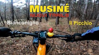
trail: Bianconiglio #1
15:36 |
12 |
Mar 8, 2026 , Almese
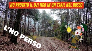
trail: Cappellaio Matto
11:33 |
281 |
Dec 11, 2024 , Almese
Recent Trail Reports
| status | trail | date | condition | info | user |
|---|---|---|---|---|---|
| Oregon | Jun 20, 2026 @ 9:07am (Europe/Monaco) 2 days | Ideal | maury-adventure | ||
| Cappellaio Matto | May 9, 2026 @ 1:20pm (Europe/Rome) May 9, 2026 | Unknown | Alberto52cFRi | ||
| Hollyday Inn | Apr 26, 2026 @ 8:36am (Europe/Rome) Apr 25, 2026 | Ideal | Medioman92 | ||
| Badola Up | Apr 9, 2026 @ 9:27am (Europe/Rome) Apr 9, 2026 | Unknown | enzo220 | ||
| Bianconiglio #2 | Apr 5, 2026 @ 3:35pm (Europe/Rome) Apr 5, 2026 | Ideal | Mattero | ||
| Bianconiglio #3 | Mar 28, 2026 @ 10:32am (Europe/Monaco) Mar 28, 2026 | Dry | Pistolero79 | ||
| BBLBB | Mar 28, 2026 @ 10:32am (Europe/Monaco) Mar 28, 2026 | Ideal | Pistolero79 | ||
| Manolo - BBLB | Mar 28, 2026 @ 10:32am (Europe/Monaco) Mar 28, 2026 | Ideal | Pistolero79 | ||
| Il Picchio | Mar 28, 2026 @ 10:32am (Europe/Monaco) Mar 28, 2026 | Dry | Pistolero79 | ||
| Pera Pluc - Manolo | Mar 28, 2026 @ 10:32am (Europe/Monaco) Mar 28, 2026 | Ideal | Pistolero79 |
Activity Feed
| username | action | type | title | date |
|---|---|---|---|---|
| maury-adventure | add | photo | activity #97416362 and 1 more | Jun 20, 2026 @ 11:23am 1 day |
| maury-adventure | add | report | activity #97389550 | Jun 20, 2026 @ 6:47am 2 days |
| VincenzoZZExQ3 | ridden | trail | activity #96944647 | Jun 14, 2026 @ 1:31am Jun 14, 2026 |
| MicheleCive | ridden | skillpark | activity #95245894 | May 22, 2026 @ 8:49am May 22, 2026 |
| Marcyuiz | ridden | trail | activity #94853313 | May 16, 2026 @ 2:41pm May 16, 2026 |
Recent Comments
| username | type | title | comment | date |
|---|---|---|---|---|
| trail | Attualmente traccia quasi invisibile coperta... | Mar 20, 2026 @ 9:45am Mar 20, 2026 | ||
| trail | Spettacolare! Grazie ai TB | Mar 18, 2026 @ 3:00pm Mar 18, 2026 | ||
| trail | Sentiero spettacolare, rispettiamolo non... | Mar 18, 2026 @ 2:58pm Mar 18, 2026 | ||
| trail | Confermo il trail dovrebbe essere segnato... | Feb 21, 2026 @ 8:41am Feb 21, 2026 | ||
| trail | Divertente e pulito. Un poco di fango negli... | Mar 8, 2025 @ 3:28am Mar 8, 2025 |
Bike & Skill Parks
| name | type | city | rating |
|---|---|---|---|
| Bike park Piero Ghibaudo | skill park | Almese |
Activity Type Stats
| activitytype | trails | distance | descent | descent distance | total vertical | rating | global rank | state rank | photos | reports | routes | ridelogs |
|---|---|---|---|---|---|---|---|---|---|---|---|---|
| Mountain Bike | 43 | 9 miles | 7,100 ft | 8 miles | 1,342 ft | #3,866 | #230 | 31 | 296 | 1,816 | ||
| E-Bike | 29 | 4 miles | 3,140 ft | 3 miles | 1,299 ft | #4,594 | #442 | 8 | 226 | 761 | ||
| Gravel Bike | 4 | 6 | ||||||||||
| Hike | 18 | 6 miles | 4,688 ft | 5 miles | 1,299 ft | #8,713 | #549 | 241 | 33 | |||
| Trail Running | 21 | 6 miles | 4,944 ft | 5 miles | 1,299 ft | #7,976 | #510 | 241 | 81 |
Frequently Asked Questions About Almese
▼
What are the highest rated mountain biking trails in Almese?
The highest rated mountain biking trails in Almese are:
- Umpalumpa (4.3/5)
- Roca Bianca (4.3/5)
- Manolo (4.2/5)
- Tacamal (4.2/5)
- Bianconiglio #2 (4.1/5)
▼
What is the best time of the year to ride in Almese?
Based on ride log data, the most popular months to ride in Almese are:
- December (4 activities)
- November (3 activities)
- January (3 activities)
▼
Where can I park to ride in Almese?
Check the Almese trail map for trailhead and parking information. Community members regularly update access and parking details for trails in the area.
▼
What is the longest trail in Almese?
The longest trail in Almese is Balconata at 2.0 miles. View all trails sorted by distance.
Activities
Trails
Points of Interest
- By bolomtb
 & contributors
 - Admins: silviu86, adessoomaipiu
- #35949 - 3,437 views
- almese activity log | embed map of Almese mountain bike trails |
Downloading of trail gps tracks in kml & gpx formats is enabled for Almese.
You must login to download files.