close
-
Layers w
- Weather Layers
- Pro
- Pro
- Pro
- Pro
- Pro
- Pro
- More Layers
- Pro
- Pro
- Pro
- Pro
-
Upgrade to

3D
Trail Conditions
- Unknown
- Snow Groomed
- Snow Packed
- Snow Covered
- Snow Cover Partial
- Freeze/thaw Cycle
- Icy
- Prevalent Mud
- Wet
- Variable
- Ideal
- Dry
- Very Dry
Trail Flow (Ridden Direction)
Trailforks scans users ridelogs to determine the most popular direction each trail is ridden. A good flowing trail network will have most trails flowing in a single direction according to their intension.
The colour categories are based on what percentage of riders are riding a trail in its intended direction.
The colour categories are based on what percentage of riders are riding a trail in its intended direction.
- > 96%
- > 90%
- > 80%
- > 70%
- > 50%
- < 50%
- bi-directional trail
- no data
Trail Last Ridden
Trailforks scans ridelogs to determine the last time a trail was ridden.
- < 2 days
- < 1 week
- < 2 weeks
- < 1 month
- < 6 months
- > 6 months
Trail Ridden Direction
The intended direction a trail should be ridden.
- Downhill Only
- Downhill Primary
- Both Directions
- Uphill Primary
- Uphill Only
- One Direction
Contribute Details
Colors indicate trail is missing specified detail.
- Description
- Photos
- Description & Photos
- Videos
Trail Popularity ?
Trailforks scans ridelogs to determine which trails are ridden the most in the last 9 months.
Trails are compared with nearby trails in the same city region with a possible 25 colour shades.
Think of this as a heatmap, more rides = more kinetic energy = warmer colors.
- most popular
- popular
- less popular
- not popular
ATV/ORV/OHV Filter
Max Vehicle Width
inches
US Cell Coverage
Legend

Radar Time
Activity Recordings
Trailforks uses anonymized public activity data.
?
Activity Recordings
Trailforks uses anonymized public activity data.
?
Personal Heatmap
▶
Activity Types
all
/
none
▶
Options
2
Date range
month
–
Winter Trails
Warning
A routing network for winter maps does not exist. Selecting trails using the winter trails layer has been disabled.
Missing Trails
Most Popular
Least Popular
Trails are colored based on popularity. The more popular a trail is, the more red. Less popular trails trend towards green.
Jump Magnitude Heatmap
Heatmap of where riders jump on trails. Zoom in to see individual jumps, click circles to view jump details.
BC Backroad Status
![map legend]()
Service Road Atlas is a free to use, community-driven service for viewing and creating reports on the numerous back-country service roads around B.C. and Alberta.

Slope Aspect
Direction the slope faces
Trails Deemphasized
Trails are shown in grey.
Only show trails with no bike usage.
Suggested Layers
Based on selected activity type
Save the current map location and zoom level as your default home location whenever this page is loaded.
Save
No description for Alpine has been added yet!
Login or register to submit one.
Activities Click to view
- Mountain Bike
49 trails
- Gravel Bike
0 trails
- Adaptive Bike
0 trails
- Hike
36 trails
- Trail Running
36 trails
Region Details
- 3
- 6
- 17
- 12
- 4
- 3
Region Status
Caution as of 1 dayLocal Trail Association
Stats
- Avg Trail Rating
- Trails (view details)
- 45
- Trails Mountain Bike
- 49
- Trails Hike
- 36
- Trails Trail Running
- 36
- Total Distance
- 22 miles
- Total Descent
- 6,935 ft
- Total Vertical
- 1,778 ft
- Highest Trailhead
- 2,823 ft
- Reports
- 189
- Photos
- 265
- Ridden Counter
- 3,309
Sub Regions
-
Anderson Truck Trail
- 4
- 5
- 4
-
Wright's Field
- 6
- 13
- 7
Popular Alpine Mountain Biking Trails
• 85 ★ 3.5 • 761 ft • 27 ft • 62 •
Popular blue difficulty singletrack. This mountain bike primary trail can be used both directions and has a easy overall physical rating with a 27 ft blue climb. It features drop, jump, rock face and wallride. On average it takes 1 minutes to complete this trail.
• 90 ★ 3.7 • 469 ft • 0 ft • 61 •
Popular black diamond difficulty singletrack. This mountain bike primary trail can be used downhill primary and has a easy overall physical rating with a 0 ft black diamond climb. It features drop, jump, rock face and wallride. On average it takes 1 minutes to complete this trail.
• 65 ★ 4.0 • 558 ft • 0 ft • 55 •
Moderately popular black diamond difficulty singletrack. This mountain bike primary trail can be used downhill primary and has a easy overall physical rating with a 0 ft blue climb. It features drop, jump, rock face and wallride. On average it takes 2 minutes to complete this trail.
• 80 ★ 3.0 • 589 ft • 8 ft • 47 •
Popular blue difficulty singletrack. This mountain bike primary trail can be used both directions and has a easy overall physical rating with a 8 ft blue climb. It features drop, jump and rock face. On average it takes 1 minutes to complete this trail.
• 85 ★ 3.7 • 2,783 ft • 5 ft • 44 •
Popular green difficulty singletrack. This mountain bike primary trail can be used both directions and has a easy overall physical rating with a 5 ft green climb. On average it takes 2 minutes to complete this trail.
• 70 ★ 2.4 • 449 ft • 0 ft • 43 •
Popular blue difficulty singletrack. This mountain bike primary trail can be used downhill primary and has a easy overall physical rating with a 0 ft blue climb. It features drop, jump and rock face. On average it takes 1 minutes to complete this trail.
• 65 ★ 3.7 • 790 ft • 0 ft • 42 •
Moderately popular black diamond difficulty singletrack. This mountain bike primary trail can be used downhill primary and has a easy overall physical rating with a 0 ft blue climb. It features drop, jump, rock face and wallride. On average it takes 1 minutes to complete this trail.
• 50 ★ 3.8 • 4,363 ft • 35 ft • 37 •
Moderately popular blue difficulty singletrack. This mountain bike primary trail can be used both directions and has a moderate overall physical rating with a 35 ft blue climb. It features jump and pump track. On average it takes 12 minutes to complete this trail.
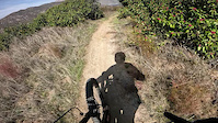
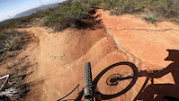
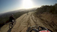
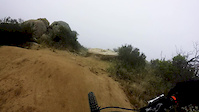
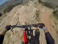
Photos of Alpine Mountain Bike
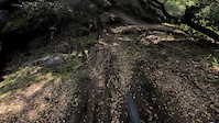
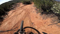
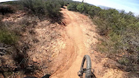
Videos of Alpine Mountain Bike
trail: Anderson Truck Trail
0:00 |
73 |
Feb 18, 2025
trail: Anderson Truck Trail
3:29 |
34 |
Feb 18, 2025
trail: Anderson Truck Trail
2:16 |
47 |
Feb 18, 2025
trail: Anderson Truck Trail
0:45 |
29 |
Feb 18, 2025
trail: Anderson Truck Trail
0:16 |
27 |
Feb 18, 2025
trail: Anderson Truck Trail
5:04 |
278 |
Sep 25, 2015
trail: Anderson Truck Trail
12:09 |
228 |
Jun 13, 2015
trail: Run 2
2:06 |
369 |
Jun 7, 2015
Recent Trail Reports
| status | trail | date | condition | info | user |
|---|---|---|---|---|---|
| Fast and Loose | Jun 19, 2026 @ 3:13pm (America/Los_Angeles) 1 day | Very Dry | chriscrisp | ||
| Carveacre Road | Dec 23, 2025 @ 6:53am (America/Los_Angeles) Dec 23, 2025 | Very Dry | BenLow2019 | ||
| Lawson Peak Trail | Dec 23, 2025 @ 6:51am (America/Los_Angeles) Dec 23, 2025 | Very Dry | BenLow2019 | ||
| Gaskill Peak Alternate | Dec 23, 2025 @ 6:49am (America/Los_Angeles) Dec 23, 2025 | Dry | BenLow2019 | ||
| Carvacre Truck Trail | Nov 24, 2025 @ 10:06am (America/Los_Angeles) Nov 24, 2025 | Ideal | BenLow2019 | ||
| Gaskill Peak Trail | Nov 10, 2025 @ 10:39am (America/Los_Angeles) Nov 10, 2025 | Very Dry | BenLow2019 | ||
| Big Momma DH | Jan 19, 2025 @ 1:57pm Jan 19, 2025 | Dry | Sassberto | ||
| Mainline - Minefield diagonal connector | Apr 19, 2024 @ 1:12am Apr 19, 2024 | Ideal | cedenburn | ||
| Minefield | Apr 19, 2024 @ 1:12am Apr 19, 2024 | Ideal | cedenburn | ||
| Mainline | Apr 19, 2024 @ 1:12am Apr 19, 2024 | Ideal | cedenburn |
Activity Feed
| username | action | type | title | date |
|---|---|---|---|---|
| ttien28 | wishlist | trail | activity #97351601 | Jun 19, 2026 @ 4:14pm 1 day |
| oc-emtb | wishlist | trail | activity #96777359 | Jun 11, 2026 @ 6:57pm Jun 11, 2026 |
| llong | wishlist | region | activity #96733971 | Jun 11, 2026 @ 6:47am Jun 11, 2026 |
| Totogogo | wishlist | trail | activity #94382396 | May 9, 2026 @ 3:20pm May 9, 2026 |
| johnparkerballistic | wishlist | trail | activity #94114747 | May 5, 2026 @ 2:28pm May 5, 2026 |
Recent Comments
| username | type | title | comment | date |
|---|---|---|---|---|
| trail | The path starts very obvious and becomes less... | Nov 17, 2025 @ 6:35am Nov 17, 2025 | ||
| trail | There's a couple options to scramble to the... | Nov 17, 2025 @ 6:30am Nov 17, 2025 | ||
| trail | J | Oct 16, 2022 @ 2:22pm Oct 16, 2022 | ||
| trail | This is (was) a fire road, but it looks like... | Feb 19, 2022 @ 6:34am Feb 19, 2022 | ||
| trail | If you start at the school you start with a... | Jan 22, 2022 @ 9:08am Jan 22, 2022 |
Local Badges
-

10 Blue Trails22 awarded -

10 Black Trails49 awarded -

Epic Ride Climb 2k10 awarded -

Climbing 10k Badge31 awarded -

Climbing 100k Badge0 awarded -

Epic Ride Descent 2k7 awarded
Activity Type Stats
| activitytype | trails | distance | descent | descent distance | total vertical | rating | global rank | state rank | photos | reports | routes | ridelogs |
|---|---|---|---|---|---|---|---|---|---|---|---|---|
| Mountain Bike | 49 | 22 miles | 6,936 ft | 15 miles | 1,778 ft | #3,576 | #1,217 | 228 | 189 | 1 | 4,864 | |
| Hike | 36 | 18 miles | 4,088 ft | 12 miles | 1,778 ft | #1,198 | #551 | 37 | 187 | 405 | ||
| Trail Running | 36 | 18 miles | 4,088 ft | 12 miles | 1,778 ft | #6,814 | #2,232 | 187 | 549 |
Frequently Asked Questions About Alpine
▼
What are the best places to ride in Alpine?
Alpine has 2 areas to explore for mountain biking. The top rated areas are:
▼
What are the highest rated mountain biking trails in Alpine?
The highest rated mountain biking trails in Alpine are:
- Rocky Road (4.3/5)
- Olivewood (4.1/5)
- Run 2 (4/5)
- Mainline (4/5)
- backside connector (4/5)
▼
What is the best time of the year to ride in Alpine?
Based on ride log data, the most popular months to ride in Alpine are:
- July (72 activities)
- May (54 activities)
- January (47 activities)
▼
Where can I park to ride in Alpine?
Trails
Points of Interest
- By SoCal-AM
 & contributors
 - Admins: SDMBA
- #8892 - 6,891 views
- alpine activity log | embed map of Alpine mountain bike trails | alpine mountain biking points of interest polygons
Downloading of trail gps tracks in kml & gpx formats is enabled for Alpine.
You must login to download files.