close
-
Layers w
- Weather Layers
- Pro
- Pro
- Pro
- Pro
- Pro
- Pro
- More Layers
- Pro
- Pro
- Pro
- Pro
-
Upgrade to

3D
Trail Conditions
- Unknown
- Snow Groomed
- Snow Packed
- Snow Covered
- Snow Cover Partial
- Freeze/thaw Cycle
- Icy
- Prevalent Mud
- Wet
- Variable
- Ideal
- Dry
- Very Dry
Trail Flow (Ridden Direction)
Trailforks scans users ridelogs to determine the most popular direction each trail is ridden. A good flowing trail network will have most trails flowing in a single direction according to their intension.
The colour categories are based on what percentage of riders are riding a trail in its intended direction.
The colour categories are based on what percentage of riders are riding a trail in its intended direction.
- > 96%
- > 90%
- > 80%
- > 70%
- > 50%
- < 50%
- bi-directional trail
- no data
Trail Last Ridden
Trailforks scans ridelogs to determine the last time a trail was ridden.
- < 2 days
- < 1 week
- < 2 weeks
- < 1 month
- < 6 months
- > 6 months
Trail Ridden Direction
The intended direction a trail should be ridden.
- Downhill Only
- Downhill Primary
- Both Directions
- Uphill Primary
- Uphill Only
- One Direction
Contribute Details
Colors indicate trail is missing specified detail.
- Description
- Photos
- Description & Photos
- Videos
Trail Popularity ?
Trailforks scans ridelogs to determine which trails are ridden the most in the last 9 months.
Trails are compared with nearby trails in the same city region with a possible 25 colour shades.
Think of this as a heatmap, more rides = more kinetic energy = warmer colors.
- most popular
- popular
- less popular
- not popular
ATV/ORV/OHV Filter
Max Vehicle Width
inches
US Cell Coverage
Legend

Radar Time
Activity Recordings
Trailforks uses anonymized public activity data.
?
Activity Recordings
Trailforks uses anonymized public activity data.
?
Personal Heatmap
▶
Activity Types
all
/
none
▶
Options
2
Date range
month
–
Winter Trails
Warning
A routing network for winter maps does not exist. Selecting trails using the winter trails layer has been disabled.
Missing Trails
Most Popular
Least Popular
Trails are colored based on popularity. The more popular a trail is, the more red. Less popular trails trend towards green.
Jump Magnitude Heatmap
Heatmap of where riders jump on trails. Zoom in to see individual jumps, click circles to view jump details.
BC Backroad Status
![map legend]()
Service Road Atlas is a free to use, community-driven service for viewing and creating reports on the numerous back-country service roads around B.C. and Alberta.

Slope Aspect
Direction the slope faces
Trails Deemphasized
Trails are shown in grey.
Only show trails with no bike usage.
Suggested Layers
Based on selected activity type
Save the current map location and zoom level as your default home location whenever this page is loaded.
Save
No description for Alpine Trails has been added yet!
Login or register to submit one.
 google parking directions

Shuttleable: YES
Land Status: National Forest
Land Manager: USFS. Willamette National Forest
google parking directions Region Supporters & Maintainers
![USFS]()
USFSSponsor![]()
Cog Wild Mountain Bike Tours & ShuttleSponsor
IMBA Ride Center
Oakridge
Activities Click to view
- Mountain Bike
28 trails
- E-Bike
18 trails
- Horse
3 trails
- Hike
29 trails
- Trail Running
29 trails
Region Details
- 13
- 2
- 12
Region Status
Open as of Jun 6, 2026Local Trail Association
Stats
- Avg Trail Rating
- Trails (view details)
- 28
- Trails Mountain Bike
- 28
- Trails E-Bike
- 18
- Trails Horse
- 3
- Trails Hike
- 29
- Trails Trail Running
- 29
- Trails Dirtbike/Moto
- 1
- Total Distance
- 72 miles
- Total Descent Distance
- 30 miles
- Total Descent
- 12,673 ft
- Total Vertical
- 3,934 ft
- Highest Trailhead
- 4,974 ft
- Reports
- 480
- Photos
- 368
- Ridden Counter
- 15,700
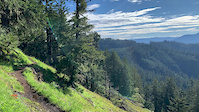
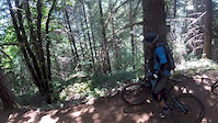
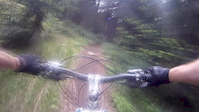
Popular Alpine Trails Mountain Biking Trails
• 100 ★ 4.4 • 9 miles • 611 ft • 2,936 •
Overview The original backcountry ride that put Oakridge on the map, this has the same start as the ATCA but you stick just to the Alpine Trail all the way down. A great combination of deep forests, narrow singletrack, and scary-fast...
• 95 ★ 4.4 • 3 miles • 794 ft • 909 •
Usually ridden as part of a loop including nearby Alpine and trails (various options exist). Some aerobic singletrack and converted double track climbs are followed by some great XC descending, some of which can be quite loose due to...
• 95 ★ 4.2 • 1 mile • 484 ft • 855 •
Tie that connects back to the enabling more singletrack in loops. Built by the GOATS in 2013.
• 95 ★ 4.5 • 3,848 ft • 313 ft • 530 •
This is a new 0.6 mile trail that is proposed by the Willamette National Forest and is currently in the planning phase. The USFS is currently reviewing the project and seeking funding for a possible 2019 start. This trail will become...
• 90 ★ 5.0 • 863 ft • 5 ft • 376 •
Popular green difficulty dirt/gravel road. This multi-use trail. On average it takes 1 minutes to complete this trail.
• 80 ★ 3.9 • 3 miles • 280 ft • 370 •
The upper section of Alpine, North of Kate's Cut In, called Chrome Toilet because of the old Forest Service shelter with a chrome toilet. Less ridden and narrower then the rest of Alpine, a great extension to an already great ride. Some...
• 85 ★ 3.6 • 3 miles • 93 ft • 327 •
This is the first segment of this trail. The overall difficulty is green however, its is intermediate due to the roots, rocks and exposure in the first 1/3 of a mile. After that its a peaceful river trail with lots of great swimming holes.
• 100 ★ 4.8 • 4 miles • 455 ft • 319 •
The section of Alpine from Kate's cut in to the bottom of the "Jedi" section. Classic PNW trail through deep forests and the Sourgrass Meadow. Some high speed sections, some connected slalom turns through trees and some open switch...
Alpine Trails Mountain Bike Routes
★ 3.7 • 24 miles • 3,529 ft • 7 • Shuttled •
The trail that helped define backcountry riding in the Oregon Cascades. By the time you finally reach the...
13 miles • 1,024 ft • 2 • Shuttled •
This is Trans Cascadia Excursions Shuttle Route for the Alpine Trail. The shuttle drop point is at Kate's...
16 miles • 2,010 ft • 9 •
Check out a map ahead of time and choose your own adventure. Just remember there’s as much climbing as...
27 miles • 4,443 ft • 2 • Race •
Discover singletrack paradise at the Alpine Epic - an XC mountain bike endurance legacy race brought to...
45 miles • 8,006 ft • 8 • Loop • Race •
Discover singletrack paradise at the Epic - an XC mountain bike endurance legacy race brought to you by...
Photos of Alpine Trails Mountain Bike
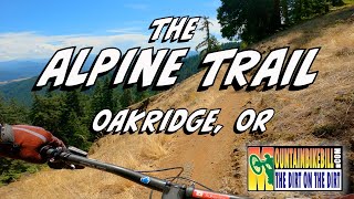
Videos of Alpine Trails Mountain Bike
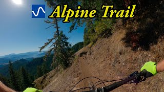
trail: Lower Alpine Trail
0:22 |
|
May 25, 2020
trail: Lower Alpine Trail
2:20 |
174 |
Jul 26, 2017

trail: Lower Alpine Trail
4:00 |
186 |
Jul 10, 2015
trail: Lower Alpine Trail
2:32 |
334 |
Jun 28, 2014

trail: Lower Alpine Trail
10:57 |
33 |
Nov 28, 2025 , Oakridge
trail: Upper Alpine Trail
10:57 |
70 |
Nov 28, 2025 , Oakridge
youtuber
![Alpine Trail]()

trail: Lower Alpine Trail
16:26 |
61 |
Oct 10, 2025 , Oakridge
youtuber
![Best mountain bike trail in Oakridge, OR -...]()
trail: Lower Alpine Trail
16:26 |
133 |
Oct 10, 2025 , Oakridge
Recent Trail Reports
| status | trail | date | condition | info | user |
|---|---|---|---|---|---|
| Lower Alpine Trail | Jun 6, 2026 @ 7:25pm (America/Los_Angeles) Jun 6, 2026 | Variable | Surly-dad | ||
| Cloverpatch Tie | May 31, 2026 @ 9:58am (America/Los_Angeles) May 31, 2026 | Ideal | KennyBraun | ||
| Tire Mountain | May 31, 2026 @ 9:58am (America/Los_Angeles) May 31, 2026 | Wet | KennyBraun | ||
| Upper Alpine Trail | May 31, 2026 @ 9:58am (America/Los_Angeles) May 31, 2026 | Prevalent Mud | KennyBraun | ||
| NF - 1912 | May 31, 2026 @ 9:58am (America/Los_Angeles) May 31, 2026 | Ideal | KennyBraun | ||
| Cloverpatch Extension (Planned 2026) | May 25, 2026 @ 4:20pm (America/Los_Angeles) May 25, 2026 | Variable | lauren199209 | ||
| Alpine Trail Chrome Toilet Section | May 9, 2026 @ 6:14pm (America/Los_Angeles) May 9, 2026 | Variable | tdeems | ||
| Winberry Divide | Mar 8, 2026 @ 7:47pm (America/Los_Angeles) Mar 8, 2026 | Ideal | trans-cascadia-excursions | ||
| Forest Road 1910 / 1911 | Jan 17, 2026 @ 10:19pm (America/Los_Angeles) Jan 17, 2026 | Ideal | MiniRipperton | ||
| Alpine Connector | Oct 8, 2025 @ 9:43am (America/Los_Angeles) Oct 8, 2025 | Ideal | Mdeniston |
Activity Feed
| username | action | type | title | date |
|---|---|---|---|---|
| Maggpie88 | wishlist | trail | activity #97206314 and 1 more | Jun 17, 2026 @ 1:23pm 9 hours |
| Maggpie88 | wishlist | route | activity #97206268 | Jun 17, 2026 @ 1:22pm 9 hours |
| PaddleIdaho | wishlist | region | activity #97194706 | Jun 17, 2026 @ 10:35am 12 hours |
| ray2002 | wishlist | route | activity #97019841 | Jun 14, 2026 @ 7:43pm Jun 14, 2026 |
| scottf2 | wishlist | route | activity #96993754 | Jun 14, 2026 @ 12:09pm Jun 14, 2026 |
Recent Comments
| username | type | title | comment | date |
|---|---|---|---|---|
| trail | If you’re visiting, worrying about which... | Jul 13, 2025 @ 8:49pm Jul 13, 2025 | ||
| report | Emtb are welcome | Jun 24, 2025 @ 5:16pm Jun 24, 2025 | ||
| trail | Road this up to Windy Pass today. Met one car.... | Apr 19, 2025 @ 6:49pm Apr 19, 2025 | ||
| trail | We started our downhill at Windy Pass today.... | Apr 19, 2025 @ 6:48pm Apr 19, 2025 | ||
| trail | Peaceful easy trail. Great little jaunt. | Dec 16, 2024 @ 10:01pm Dec 16, 2024 |
Nearby Areas
| name | distance | ||||
|---|---|---|---|---|---|
| Dead Mountain | 7 | 5 | 2 | 5.3 km | |
| Larison Trails | 1 | 3 | 1 | 7.6 km | |
| Hardesty Portal | 1 | 10 | 2 | 1 | 8 km |
| Cottage Grove OHV Trails | 1 | 2 | 14.9 km | ||
| Diamond Creek Area | 3 | 21.8 km |
Local Badges
-

Completionist0 awarded
Bike & Skill Parks
| name | type | city | rating |
|---|---|---|---|
| Office Covered Bridge Pumptrack | skill park | Oakridge |
Local Products
Activity Type Stats
| activitytype | trails | distance | descent | descent distance | total vertical | rating | global rank | state rank | photos | reports | routes | ridelogs |
|---|---|---|---|---|---|---|---|---|---|---|---|---|
| Mountain Bike | 28 | 72 miles | 12,674 ft | 30 miles | 3,934 ft | #2,433 | #838 | 360 | 480 | 5 | 5,622 | |
| E-Bike | 18 | 56 miles | 11,053 ft | 25 miles | 3,934 ft | #454 | #583 | 4 | 420 | 3 | 434 | |
| Horse | 3 | 8 miles | 1,037 ft | 5 miles | 3,468 ft | #2,296 | #1,256 | 115 | ||||
| Hike | 29 | 72 miles | 12,674 ft | 30 miles | 3,934 ft | #3,502 | #1,211 | 4 | 480 | 115 | ||
| Trail Running | 29 | 72 miles | 12,674 ft | 30 miles | 3,934 ft | #2,727 | #681 | 480 | 1 | 87 | ||
| Dirtbike/Moto | 1 | 3 miles | 1,007 ft | 2 miles | 932 ft | 94 | 6 |
Frequently Asked Questions About Alpine Trails
▼
What are the highest rated mountain biking trails in Alpine Trails?
The highest rated mountain biking trails in Alpine Trails are:
- Upper Alpine Trail (4.6/5)
- Lower Alpine Trail (4.3/5)
- Cloverpatch Trail (4.2/5)
- North Fork Trail (4.1/5)
- Alpine Connector (4.1/5)
▼
What is the best time of the year to ride in Alpine Trails?
Based on ride log data, the most popular months to ride in Alpine Trails are:
- July (208 activities)
- June (133 activities)
- August (89 activities)
▼
Where can I park to ride in Alpine Trails?
There are 2 parking locations listed in Alpine Trails. The most popular parking spots are:
▼
What is the longest trail in Alpine Trails?
The longest trail in Alpine Trails is Lower Alpine Trail at 13.8 km. View all trails sorted by distance.
Activities
Trails
Points of Interest
- By brenthillier
 NSMBA TRAILFORKS & contributors
 - Admins: OTA, OTA, OTA
- #21236 - 14,637 views
- alpine trails activity log | embed map of Alpine Trails mountain bike trails | alpine trails mountain biking points of interest
Downloading of trail gps tracks in kml & gpx formats is enabled for Alpine Trails.
You must login to download files.