close
-
Layers w
- Weather Layers
- Pro
- Pro
- Pro
- Pro
- Pro
- Pro
- More Layers
- Pro
- Pro
- Pro
- Pro
-
Upgrade to

3D
Trail Conditions
- Unknown
- Snow Groomed
- Snow Packed
- Snow Covered
- Snow Cover Partial
- Freeze/thaw Cycle
- Icy
- Prevalent Mud
- Wet
- Variable
- Ideal
- Dry
- Very Dry
Trail Flow (Ridden Direction)
Trailforks scans users ridelogs to determine the most popular direction each trail is ridden. A good flowing trail network will have most trails flowing in a single direction according to their intension.
The colour categories are based on what percentage of riders are riding a trail in its intended direction.
The colour categories are based on what percentage of riders are riding a trail in its intended direction.
- > 96%
- > 90%
- > 80%
- > 70%
- > 50%
- < 50%
- bi-directional trail
- no data
Trail Last Ridden
Trailforks scans ridelogs to determine the last time a trail was ridden.
- < 2 days
- < 1 week
- < 2 weeks
- < 1 month
- < 6 months
- > 6 months
Trail Ridden Direction
The intended direction a trail should be ridden.
- Downhill Only
- Downhill Primary
- Both Directions
- Uphill Primary
- Uphill Only
- One Direction
Contribute Details
Colors indicate trail is missing specified detail.
- Description
- Photos
- Description & Photos
- Videos
Trail Popularity ?
Trailforks scans ridelogs to determine which trails are ridden the most in the last 9 months.
Trails are compared with nearby trails in the same city region with a possible 25 colour shades.
Think of this as a heatmap, more rides = more kinetic energy = warmer colors.
- most popular
- popular
- less popular
- not popular
ATV/ORV/OHV Filter
Max Vehicle Width
inches
US Cell Coverage
Legend

Radar Time
Activity Recordings
Trailforks uses anonymized public activity data.
?
Activity Recordings
Trailforks uses anonymized public activity data.
?
Personal Heatmap
▶
Activity Types
all
/
none
▶
Options
2
Date range
month
–
Winter Trails
Warning
A routing network for winter maps does not exist. Selecting trails using the winter trails layer has been disabled.
Missing Trails
Most Popular
Least Popular
Trails are colored based on popularity. The more popular a trail is, the more red. Less popular trails trend towards green.
Jump Magnitude Heatmap
Heatmap of where riders jump on trails. Zoom in to see individual jumps, click circles to view jump details.
BC Backroad Status
![map legend]()
Service Road Atlas is a free to use, community-driven service for viewing and creating reports on the numerous back-country service roads around B.C. and Alberta.

Slope Aspect
Direction the slope faces
Trails Deemphasized
Trails are shown in grey.
Only show trails with no bike usage.
Suggested Layers
Based on selected activity type
Save the current map location and zoom level as your default home location whenever this page is loaded.
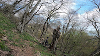
SaveThere is a developed system of the lower trails in Alushta that starts at altitudes up to 1000 m high. Trails are very diverse, mostly built by cyclists for cyclists and there are really plenty of them: fast and slow, up and down, with lots of switchbacks, steep descends and demanding traverse sections. In other words routes can be very long and intense. Daily routes consists of different trails interconnected in a such a way to let riders enjoy up to 20 km of technical riding with up to 1000 m of descent down to the seashore. This is the most popular way of mountain riding in Alushta and it is possible to make up to 4 of these type of routes per day.
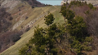
There are also trails higher up to 1500 m on Chatyr-Dag, Demerdzhi, Karaby plateau with elevations up to 1500 m and total ascent about 700 m and more. These high-mountain trails are more rocky, more technically demanding, though cyclists use them less than the lower ones. But it’s compensated with beautiful scenery and breathtaking views. Best photos and vivid emotions are there as well.
There are also trails higher up to 1500 m on Chatyr-Dag, Demerdzhi, Karaby plateau with elevations up to 1500 m and total ascent about 700 m and more. These high-mountain trails are more rocky, more technically demanding, though cyclists use them less than the lower ones. But it’s compensated with beautiful scenery and breathtaking views. Best photos and vivid emotions are there as well.
This region uses the Uk/Euro style trail grading system.
Region Supporters & Maintainers
since 2012Builder![]()
Biketest ATAS
since 2015Builder
Activities Click to view
- Mountain Bike
214 trails
- E-Bike
214 trails
- Gravel Bike
0 trails
Region Details
- 85
- 16
- 60
- 46
- 5
- 2
Region Status
Open as of May 17, 2026Stats
- Avg Trail Rating
- Trails (view details)
- 214
- Trails Mountain Bike
- 214
- Trails E-Bike
- 214
- Total Distance
- 304 miles
- Total Descent Distance
- 155 miles
- Total Descent
- 95,722 ft
- Total Vertical
- 4,896 ft
- Highest Trailhead
- 4,919 ft
- Reports
- 738
- Photos
- 316
- Ridden Counter
- 10,797
Sub Regions
-
Виноградные Трейлы
- 6
- 15
- 11
-
Демерджи
- 3
- 18
- 12
- 3
- 2
-
Канака
- 2
- 4
- 2
-
Лучистые трейлы
- 5
- 20
- 10
- 1
-
Чатыр-Даг
- 2
- 9
- 1
Popular Alushta Mountain Biking Trails
• 90 ★ 4.6 • 630 ft • 0 ft • 195 •
Popular green difficulty singletrack. This mountain bike primary trail can be used downhill only and has a moderate overall physical rating. Trail visibility is always easy to follow. On average it takes minutes to complete this trail.
• 100 ★ 5.0 • 820 ft • 0 ft • 191 •
Popular blue difficulty singletrack. This mountain bike primary trail can be used downhill only and has a moderate overall physical rating with a 0 ft green climb. It features pump track. Trail visibility is sometimes hard to follow. On average it takes 3 minutes to complete this trail.
• 100 ★ 5.0 • 3,038 ft • 6 ft • 181 •
Highly rated popular blue difficulty singletrack. This mountain bike primary trail can be used downhill only and has a moderate overall physical rating with a 6 ft green climb. It features roller coaster and skinny. Trail visibility is sometimes hard to follow. On average it takes 4 minutes to complete this trail.
• 90 ★ 5.0 • 3,907 ft • 38 ft • 176 •
Popular red difficulty singletrack. This mountain bike primary trail can be used downhill only. On average it takes 5 minutes to complete this trail.
• 100 ★ 0.0 • 3,842 ft • 16 ft • 170 •
Popular blue difficulty singletrack. This mountain bike primary trail can be used downhill only and has a moderate overall physical rating with a 16 ft blue climb. Trail visibility is always easy to follow. On average it takes 3 minutes to complete this trail.
• 95 ★ 5.0 • 2,474 ft • 0 ft • 162 •
Highly rated popular blue difficulty singletrack. This mountain bike primary trail can be used downhill only and has a moderate overall physical rating with a 0 ft blue climb. It features berm, drop, jump, rock face, rock garden and other. Trail visibility is sometimes hard to follow. On average it takes 4 minutes to complete this trail.
• 85 ★ 4.9 • 2 miles • 56 ft • 158 •
Один из лучших флоу трейлов Алушты! 4 км нонстоп скорости и флоу
Alushta Mountain Bike Routes
14 miles • 2,594 ft • 10 • Shuttled •
Связка классических уклонистых трейлов начиная от...
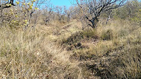
Photos of Alushta Mountain Bike
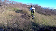
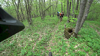
Videos of Alushta Mountain Bike

trail: Лавровый
0:40 |
16 |
Mar 18, 2023
trail: Мрiя
0:15 |
73 |
Apr 30, 2022
trail: Иван
0:00 |
45 |
Nov 11, 2021
trail: Траектория РЭС
0:15 |
72 |
Jun 21, 2020
trail: Мамонтовая
0:42 |
156 |
Apr 17, 2020
trail: Корона
0:10 |
54 |
Apr 14, 2020
trail: Корона
3:12 |
106 |
Apr 8, 2020
trail: Сосновка
2:57 |
61 |
May 7, 2019
Recent Trail Reports
| status | trail | date | condition | info | user |
|---|---|---|---|---|---|
| Склеп графини Гратень | Apr 10, 2023 @ 3:00pm Apr 10, 2023 | Unknown | Jahtaka TBRU | ||
| Выкат от Чайковского | Apr 10, 2023 @ 3:00pm Apr 10, 2023 | Unknown | Jahtaka TBRU | ||
| Chalbash | Apr 10, 2023 @ 3:00pm Apr 10, 2023 | Unknown | Jahtaka TBRU | ||
| Acces to Dolgorukovskaya Trails | Apr 10, 2023 @ 3:00pm Apr 10, 2023 | Unknown | Jahtaka TBRU | ||
| Красная пещера | Apr 10, 2023 @ 3:00pm Apr 10, 2023 | Unknown | Jahtaka TBRU | ||
| Мечта | Apr 10, 2023 @ 3:00pm Apr 10, 2023 | Unknown | Jahtaka TBRU | ||
| Kizil-Koba Acsess | Apr 10, 2023 @ 3:00pm Apr 10, 2023 | Unknown | Jahtaka TBRU | ||
| Южная тропа | Apr 10, 2023 @ 3:00pm Apr 10, 2023 | Unknown | Jahtaka TBRU | ||
| Подъём к Иванычу | Apr 10, 2023 @ 3:00pm Apr 10, 2023 | Unknown | Jahtaka TBRU | ||
| Козья Тропа | Apr 10, 2023 @ 3:00pm Apr 10, 2023 | Unknown | Jahtaka TBRU |
Activity Feed
| username | action | type | title | date |
|---|---|---|---|---|
| IgorKutnikov | wishlist | trail | activity #79225686 | Aug 30, 2025 @ 1:36am Aug 30, 2025 |
| IgorKutnikov | wishlist | trail | activity #78906133 | Aug 25, 2025 @ 5:39am Aug 25, 2025 |
| ivlexey | ridden | trail | activity #70608029 | Apr 29, 2025 @ 2:39am Apr 29, 2025 |
| ivlexey | ridden | trail | activity #70466831 | Apr 27, 2025 @ 2:29am Apr 27, 2025 |
| ivlexey | wishlist | trail | activity #69670182 | Apr 15, 2025 @ 3:02am Apr 15, 2025 |
Recent Comments
| username | type | title | comment | date |
|---|---|---|---|---|
| trail | why is a proline? | Feb 10, 2025 @ 3:52am Feb 10, 2025 | ||
| report | Че за nah | Sep 15, 2024 @ 9:03am Sep 15, 2024 | ||
| trail | Данный трек незаконно... | Apr 11, 2023 @ 11:43pm Apr 11, 2023 | ||
| trail | Данный трек незаконно... | Apr 11, 2023 @ 11:43pm Apr 11, 2023 | ||
| trail | Данный трек незаконно... | Apr 11, 2023 @ 1:43pm Apr 11, 2023 |
Local Badges
-

Epic Ride Climb 2k203 awarded -

Climbing 10k Badge75 awarded -

Climbing 100k Badge3 awarded -

Epic Ride Descent 2k539 awarded -

Descent 10k Badge90 awarded -

Descent 100k Badge12 awarded
Activity Type Stats
| activitytype | trails | distance | descent | descent distance | total vertical | rating | global rank | state rank | photos | reports | routes | ridelogs |
|---|---|---|---|---|---|---|---|---|---|---|---|---|
| Mountain Bike | 214 | 304 miles | 95,722 ft | 155 miles | 4,895 ft | #283 | #1 | 316 | 735 | 2 | 7,200 | |
| E-Bike | 214 | 304 miles | 95,722 ft | 155 miles | 4,895 ft | #178 | #1 | 703 | 2 | 302 |
Frequently Asked Questions About Alushta
▼
What are the best places to ride in Alushta?
Alushta has 5 areas to explore for mountain biking. The top rated areas are:
▼
What are the highest rated mountain biking trails in Alushta?
The highest rated mountain biking trails in Alushta are:
- Мадера (4.6/5)
- Кастель (4.6/5)
- Мховый (4.5/5)
- Лучистый (4.5/5)
- Тролль-трейл (4.5/5)
▼
What is the best time of the year to ride in Alushta?
Based on ride log data, the most popular months to ride in Alushta are:
- May (62 activities)
- April (51 activities)
- September (46 activities)
▼
Where can I park to ride in Alushta?
Check the Alushta trail map for trailhead and parking information. Community members regularly update access and parking details for trails in the area.
Trails
- By Jahtaka TBRU & contributors
- Admins: Jahtaka
- #13243 - 17,148 views
- alushta activity log | embed map of Alushta mountain bike trails | alushta mountain biking points of interest polygons
Downloading of trail gps tracks in kml & gpx formats is enabled for Alushta.
You must login to download files.