close
-
Layers w
- Weather Layers
- Pro
- Pro
- Pro
- Pro
- Pro
- Pro
- More Layers
- Pro
- Pro
- Pro
- Pro
-
Upgrade to

3D
Trail Conditions
- Unknown
- Snow Groomed
- Snow Packed
- Snow Covered
- Snow Cover Partial
- Freeze/thaw Cycle
- Icy
- Prevalent Mud
- Wet
- Variable
- Ideal
- Dry
- Very Dry
Trail Flow (Ridden Direction)
Trailforks scans users ridelogs to determine the most popular direction each trail is ridden. A good flowing trail network will have most trails flowing in a single direction according to their intension.
The colour categories are based on what percentage of riders are riding a trail in its intended direction.
The colour categories are based on what percentage of riders are riding a trail in its intended direction.
- > 96%
- > 90%
- > 80%
- > 70%
- > 50%
- < 50%
- bi-directional trail
- no data
Trail Last Ridden
Trailforks scans ridelogs to determine the last time a trail was ridden.
- < 2 days
- < 1 week
- < 2 weeks
- < 1 month
- < 6 months
- > 6 months
Trail Ridden Direction
The intended direction a trail should be ridden.
- Downhill Only
- Downhill Primary
- Both Directions
- Uphill Primary
- Uphill Only
- One Direction
Contribute Details
Colors indicate trail is missing specified detail.
- Description
- Photos
- Description & Photos
- Videos
Trail Popularity ?
Trailforks scans ridelogs to determine which trails are ridden the most in the last 9 months.
Trails are compared with nearby trails in the same city region with a possible 25 colour shades.
Think of this as a heatmap, more rides = more kinetic energy = warmer colors.
- most popular
- popular
- less popular
- not popular
ATV/ORV/OHV Filter
Max Vehicle Width
inches
US Cell Coverage
Legend

Radar Time
Activity Recordings
Trailforks uses anonymized public activity data.
?
Activity Recordings
Trailforks uses anonymized public activity data.
?
Personal Heatmap
▶
Activity Types
all
/
none
▶
Options
2
Date range
month
–
Winter Trails
Warning
A routing network for winter maps does not exist. Selecting trails using the winter trails layer has been disabled.
Missing Trails
Most Popular
Least Popular
Trails are colored based on popularity. The more popular a trail is, the more red. Less popular trails trend towards green.
Jump Magnitude Heatmap
Heatmap of where riders jump on trails. Zoom in to see individual jumps, click circles to view jump details.
BC Backroad Status
![map legend]()
Service Road Atlas is a free to use, community-driven service for viewing and creating reports on the numerous back-country service roads around B.C. and Alberta.

Slope Aspect
Direction the slope faces
Trails Deemphasized
Trails are shown in grey.
Only show trails with no bike usage.
Suggested Layers
Based on selected activity type
Save the current map location and zoom level as your default home location whenever this page is loaded.
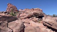
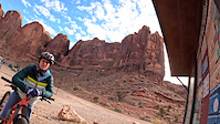
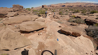
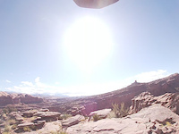
SaveSome of Moab's best enduro riding and most spectacular scenery, located so close to town you don't even need a car. Hit Ahab for a quick loop after work, session it a few times, or hit Jackson's for incredible views of the Colorado River.
Primary Trail Type: All-Mountain & Downhill
eBikes Allowed:
Yes
Land Manager: BLM
 google parking directions
 Activities Click to view
- Mountain Bike
30 trails
- E-Bike
12 trails
- Horse
1 trails
- Hike
37 trails
- Trail Running
37 trails
Region Details
- 4
- 1
- 4
- 8
- 5
Region Status
Open as of May 18, 2026Local Trail Association
Stats
- Avg Trail Rating
- Trails (view details)
- 27
- Trails Mountain Bike
- 30
- Trails E-Bike
- 12
- Trails Gravel Bike
- 2
- Trails Adaptive Bike
- 1
- Trails Horse
- 1
- Trails Hike
- 37
- Trails Trail Running
- 37
- Trails Dirtbike/Moto
- 4
- Trails ATV/ORV/OHV
- 4
- Total Distance
- 33 miles
- Total Descent
- 5,642 ft
- Total Vertical
- 1,790 ft
- Highest Trailhead
- 5,735 ft
- Reports
- 859
- Photos
- 592
- Ridden Counter
- 57,249
Popular Amasa Back Mountain Biking Trails
• 100 ★ 4.8 • 2 miles • 145 ft • 8,347 •
Jewel of the area, relatively new to the other trails. Fun transitions and some great little rock drops. is a bit easier, so if you are unsure of your skill, start there, and then climb back up to do .
• 100 ★ 4.6 • 3,010 ft • 116 ft • 7,756 •
Upper section of , connecting the Ahab midpoint to the top.
• 100 ★ 4.5 • 2 miles • 762 ft • 7,683 •
An awesome MTB singletrack alternative to dodging the jeeps on the road. Works great in both directions. This trail has some difficult sections of rock to climb, but it is pretty typical singletrack in Moab, and provides mostly a nice...
• 100 ★ 4.6 • 2 miles • 426 ft • 7,417 •
low angle but punchy technical climbing leads to a low angle but well featured decent. With skill its possible to carry quite a bit of speed all the way to the bottom. A must ride loop.
• 90 ★ 4.2 • 1,605 ft • 28 ft • 4,613 •
Singletrack between Kane Creek Road and the creek itself; the start of any ride on . Not difficult, pretty smooth, but a bit steep and tight in spots.
• 85 ★ 3.9 • 886 ft • 30 ft • 1,765 •
Cliff Hanger (alt) is a short bypass of a difficult section of the main trail, for non-motorized users only. All motorized vehicles MUST stick to the main trail.
• 80 ★ 4.0 • 1 mile • 63 ft • 1,705 •
Highly rated popular black diamond difficulty singletrack. This multi-use trail can be used both directions and has a hard overall physical rating with a 63 ft black diamond climb. It features drop, rock face and rock garden. Exposure: High Risk of Serious Injury. Trail visibility is always easy to follow. On average it takes 10 minutes to complete this trail.
Amasa Back Mountain Bike Routes
Moab Double Down Featured
★ 3.0 • 14 miles • 2,239 ft • 9 • Loop •
This is a double loop that serves up 2 of the best expert downhill trails in Moab. The first leg of the...
★ 4.0 • 9 miles • 1,569 ft • 6 • Loop •
If you've ridden the classic "life or death" Portal trail in Moab, it's a bit hard to see why Captain Ahab...
★ 5.0 • 14 miles • 2,106 ft • 12 • Out & Back •
is an awesome riding area with loads of options. For this route we suggest climbing up either the Cliff...
★ 5.0 • 6 miles • 808 ft • 11 •
Good option if you don't want to do the full Ahab Loop
★ 4.0 • 14 miles • 2,285 ft • 9 •
Trying to link up Ahab and Jacksons. How hard could it be?
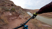
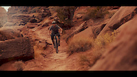
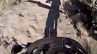
Photos of Amasa Back Mountain Bike
Videos of Amasa Back Mountain Bike
trail: Captain Ahab (lower)
0:11 |
27 |
May 10, 2025
trail: Captain Ahab (lower)
2:43 |
29 |
Mar 24, 2025
trail: Captain Ahab (lower)
0:11 |
170 |
Mar 26, 2022
trail: Captain Ahab (lower)
7:42 |
23 |
Dec 2, 2020
trail: Captain Ahab (lower)
8:08 |
64 |
Feb 22, 2020
trail: Jackson
0:39 |
146 |
Dec 10, 2019
trail: Captain Ahab (lower)
2:05 |
303 |
Feb 21, 2018
trail: Captain Ahab (lower)
0:02 |
95 |
Feb 11, 2018
Recent Trail Reports
Activity Feed
| username | action | type | title | date |
|---|---|---|---|---|
| dgbos | wishlist | route | activity #96716296 | Jun 10, 2026 @ 8:38pm Jun 10, 2026 |
| uvmskier | wishlist | route | activity #96110295 | Jun 2, 2026 @ 2:34pm Jun 2, 2026 |
| kortezianka | vote | trail | activity #96063646 and 1 more | Jun 1, 2026 @ 10:50pm Jun 1, 2026 |
| ColedF7QtI | wishlist | trail | activity #96062684 | Jun 1, 2026 @ 10:08pm Jun 1, 2026 |
| SteveMcBee5ou | wishlist | route | activity #96028995 | Jun 1, 2026 @ 11:01am Jun 1, 2026 |
Recent Comments
| username | type | title | comment | date |
|---|---|---|---|---|
| trail | Im so glad im not one of those poor suckers... | May 28, 2026 @ 7:07pm May 28, 2026 | ||
| trail | Worth the ride up. You will have to roll on... | May 28, 2026 @ 7:05pm May 28, 2026 | ||
| trail | Cliffhanger rd not Rockstacker rd for prev... | May 28, 2026 @ 7:01pm May 28, 2026 | ||
| trail | I recommend for a loop continue up Rockstacker... | May 28, 2026 @ 7:01pm May 28, 2026 | ||
| trail | Super fun climb - if you are a technical climb... | May 5, 2026 @ 1:15pm May 5, 2026 |
Nearby Areas
| name | distance | ||||
|---|---|---|---|---|---|
| Mag 7 | 2 | 10 | 4 | 2 | 5.3 km |
| Sand Flats Recreation Area | 2 | 16 | 4 | 1 | 6.3 km |
| Dead Horse Point | 5 | 8 | 1 | 6.8 km | |
| Moab Brand Trails | 11 | 11 | 4 | 1 | 9.5 km |
| Horsethief | 5 | 10 | 11.1 km |
Local Badges
-

Completionist3 awarded
Activity Type Stats
| activitytype | trails | distance | descent | descent distance | total vertical | rating | global rank | state rank | photos | reports | routes | ridelogs |
|---|---|---|---|---|---|---|---|---|---|---|---|---|
| Mountain Bike | 30 | 28 miles | 5,036 ft | 12 miles | 1,020 ft | #490 | #187 | 588 | 922 | 14 | 20,256 | |
| E-Bike | 12 | 5 miles | 417 ft | 1 mile | 981 ft | #5,053 | #1,400 | 765 | 398 | |||
| Gravel Bike | 2 | #109 | #42 | 3 | ||||||||
| Adaptive Bike | 1 | #109 | #42 | |||||||||
| Horse | 1 | #3,062 | #1,782 | 272 | ||||||||
| Hike | 37 | 33 miles | 5,643 ft | 14 miles | 1,791 ft | #2,123 | #841 | 11 | 915 | 1 | 800 | |
| Trail Running | 37 | 33 miles | 5,643 ft | 14 miles | 1,791 ft | #3,983 | #1,117 | 915 | 6 | 343 | ||
| Dirtbike/Moto | 4 | 5 miles | 417 ft | 1 mile | 981 ft | 235 | 24 | |||||
| ATV/ORV/OHV | 4 | 5 miles | 417 ft | 1 mile | 981 ft | 2 | 234 | 8 |
Frequently Asked Questions About Amasa Back
▼
What are the highest rated mountain biking trails in Amasa Back?
The highest rated mountain biking trails in Amasa Back are:
- Captain Ahab (lower) (4.7/5)
- Captain Ahab (upper) (4.5/5)
- HyMasa (upper) (4.5/5)
- HyMasa (4.5/5)
- Jackson (4.3/5)
▼
What is the best time of the year to ride in Amasa Back?
Based on ride log data, the most popular months to ride in Amasa Back are:
- October (310 activities)
- May (144 activities)
- September (138 activities)
▼
Where can I park to ride in Amasa Back?
There are 6 parking locations listed in Amasa Back. The most popular parking spots are: View all parking and trailhead locations on the map to plan your visit.
▼
What is the longest trail in Amasa Back?
The longest trail in Amasa Back is Cliff Hanger at 3.8 miles. View all trails sorted by distance.
Activities
Trails
- By canadaka
 Trailforks & contributors
 - Admins: MTM, MMBA, GrandCountyTrails
- #4726 - 28,847 views
- amasa back activity log | embed map of Amasa Back mountain bike trails | amasa back mountain biking points of interest
Downloading of trail gps tracks in kml & gpx formats is enabled for Amasa Back.
You must login to download files.