close
-
Layers w
- Weather Layers
- Pro
- Pro
- Pro
- Pro
- Pro
- Pro
- More Layers
- Pro
- Pro
- Pro
- Pro
-
Upgrade to

3D
Trail Conditions
- Unknown
- Snow Groomed
- Snow Packed
- Snow Covered
- Snow Cover Partial
- Freeze/thaw Cycle
- Icy
- Prevalent Mud
- Wet
- Variable
- Ideal
- Dry
- Very Dry
Trail Flow (Ridden Direction)
Trailforks scans users ridelogs to determine the most popular direction each trail is ridden. A good flowing trail network will have most trails flowing in a single direction according to their intension.
The colour categories are based on what percentage of riders are riding a trail in its intended direction.
The colour categories are based on what percentage of riders are riding a trail in its intended direction.
- > 96%
- > 90%
- > 80%
- > 70%
- > 50%
- < 50%
- bi-directional trail
- no data
Trail Last Ridden
Trailforks scans ridelogs to determine the last time a trail was ridden.
- < 2 days
- < 1 week
- < 2 weeks
- < 1 month
- < 6 months
- > 6 months
Trail Ridden Direction
The intended direction a trail should be ridden.
- Downhill Only
- Downhill Primary
- Both Directions
- Uphill Primary
- Uphill Only
- One Direction
Contribute Details
Colors indicate trail is missing specified detail.
- Description
- Photos
- Description & Photos
- Videos
Trail Popularity ?
Trailforks scans ridelogs to determine which trails are ridden the most in the last 9 months.
Trails are compared with nearby trails in the same city region with a possible 25 colour shades.
Think of this as a heatmap, more rides = more kinetic energy = warmer colors.
- most popular
- popular
- less popular
- not popular
ATV/ORV/OHV Filter
Max Vehicle Width
inches
US Cell Coverage
Legend

Radar Time
Activity Recordings
Trailforks uses anonymized public activity data.
?
Activity Recordings
Trailforks uses anonymized public activity data.
?
Personal Heatmap
▶
Activity Types
all
/
none
▶
Options
2
Date range
month
–
Winter Trails
Warning
A routing network for winter maps does not exist. Selecting trails using the winter trails layer has been disabled.
Missing Trails
Most Popular
Least Popular
Trails are colored based on popularity. The more popular a trail is, the more red. Less popular trails trend towards green.
Jump Magnitude Heatmap
Heatmap of where riders jump on trails. Zoom in to see individual jumps, click circles to view jump details.
BC Backroad Status
![map legend]()
Service Road Atlas is a free to use, community-driven service for viewing and creating reports on the numerous back-country service roads around B.C. and Alberta.

Slope Aspect
Direction the slope faces
Trails Deemphasized
Trails are shown in grey.
Only show trails with no bike usage.
Suggested Layers
Based on selected activity type
Save the current map location and zoom level as your default home location whenever this page is loaded.
Save
No description for Ancona has been added yet!
Login or register to submit one.
This region uses the Uk/Euro style trail grading system.
Activities Click to view
- Mountain Bike
47 trails
- E-Bike
38 trails
- Hike
43 trails
- Trail Running
39 trails
- Dirtbike/Moto
11 trails
Region Details
- 14
- 4
- 11
- 15
Stats
- Avg Trail Rating
- Trails (view details)
- 46
- Trails Mountain Bike
- 47
- Trails E-Bike
- 38
- Trails Horse
- 3
- Trails Hike
- 43
- Trails Trail Running
- 39
- Trails Dirtbike/Moto
- 11
- Total Distance
- 21 miles
- Total Descent
- 11,445 ft
- Total Vertical
- 2,313 ft
- Highest Trailhead
- 2,330 ft
- Reports
- 298
- Photos
- 53
- Ridden Counter
- 3,037
Sub Regions
- Chiaravalle (4)
- Fabriano (15)
- Monte Conero (28)
Popular Ancona Mountain Biking Trails
• 85 ★ 4.6 • 4,134 ft • 0 ft • 133 •
Highly rated popular red difficulty singletrack. This mountain bike primary trail can be used downhill only. It features drop. On average it takes 8 minutes to complete this trail.
• 75 ★ 4.2 • 5,033 ft • 0 ft • 124 •
Highly rated popular blue difficulty singletrack. This mountain bike primary trail can be used downhill only. On average it takes 9 minutes to complete this trail.
• 90 ★ 3.4 • 3,009 ft • 0 ft • 99 •
Popular blue difficulty singletrack. This mountain bike primary trail can be used downhill primary. On average it takes 3 minutes to complete this trail.
• 65 ★ 3.9 • 3,803 ft • 3 ft • 84 •
Moderately popular blue difficulty singletrack. This mountain bike primary trail can be used downhill primary. On average it takes 5 minutes to complete this trail.
• 90 ★ 2.3 • 2,569 ft • 0 ft • 73 •
Popular blue difficulty singletrack. This mountain bike primary trail can be used downhill primary. On average it takes 2 minutes to complete this trail.
• 65 ★ 3.0 • 3,048 ft • 19 ft • 69 •
Moderately popular green difficulty singletrack. This mountain bike primary trail can be used downhill only. On average it takes 3 minutes to complete this trail.
• 45 ★ 4.0 • 1 mile • 0 ft • 68 •
Highly rated moderately popular red difficulty singletrack. This multi-use trail can be used downhill only. It features rock garden. On average it takes 14 minutes to complete this trail.
• 55 ★ 3.8 • 4,196 ft • 6 ft • 65 •
Moderately popular green difficulty singletrack. This mountain bike primary trail can be used both directions. On average it takes 11 minutes to complete this trail.
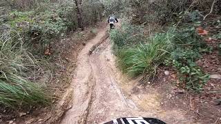
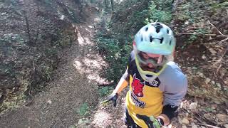
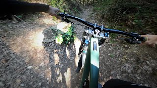
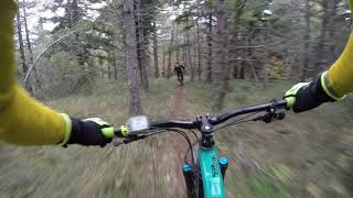
Photos of Ancona Mountain Bike
Videos of Ancona Mountain Bike
trail: Convento
6:30 |
507 |
Dec 7, 2022 , Ancona
trail: Il Tossico
4:31 |
376 |
Nov 5, 2022 , My City
trail: 3 Grazie
3:18 |
543 |
Nov 5, 2022 , My City
trail: Tutti al Mare!
10:27 |
462 |
Jun 14, 2021 , Ancona

trail: Convento
10:27 |
290 |
Jun 14, 2021 , Ancona

trail: 3 Grazie
10:27 |
373 |
Jun 14, 2021 , My City
Recent Trail Reports
| status | trail | date | condition | info | user |
|---|---|---|---|---|---|
| Upupa Monte Conero | Apr 5, 2026 @ 2:27pm (Europe/Rome) Apr 5, 2026 | Ideal | trailaddicted | ||
| Down Under Monte Conero | Apr 5, 2026 @ 2:27pm (Europe/Rome) Apr 5, 2026 | Ideal | trailaddicted | ||
| Belvedere nord - Pian Grande - Poggio Monte Conero | Apr 4, 2026 @ 7:19pm (Europe/Rome) Apr 4, 2026 | Ideal | trailaddicted | ||
| Il Poggio - variante osteria Monte Conero | Apr 4, 2026 @ 7:18pm (Europe/Rome) Apr 4, 2026 | Ideal | trailaddicted | ||
| Il Matto Monte Conero | Apr 4, 2026 @ 7:18pm (Europe/Rome) Apr 4, 2026 | Ideal | trailaddicted | ||
| 3 Grazie Monte Conero | Apr 4, 2026 @ 7:18pm (Europe/Rome) Apr 4, 2026 | Ideal | trailaddicted | ||
| Tutti al Mare! Monte Conero | Apr 4, 2026 @ 7:18pm (Europe/Rome) Apr 4, 2026 | Ideal | trailaddicted | ||
| Convento Monte Conero | Apr 4, 2026 @ 7:17pm (Europe/Rome) Apr 4, 2026 | Ideal | trailaddicted | ||
| Il Budello Monte Conero | Apr 4, 2026 @ 7:17pm (Europe/Rome) Apr 4, 2026 | Ideal | trailaddicted | ||
| Palo - Tossico Connection Monte Conero | Apr 4, 2026 @ 7:17pm (Europe/Rome) Apr 4, 2026 | Ideal | trailaddicted |
Activity Feed
| username | action | type | title | date |
|---|---|---|---|---|
| soba | vote | trail | activity #96804793 | Jun 12, 2026 @ 8:04am Jun 12, 2026 |
| Smilzo80 | vote | trail | activity #96552551 and 2 more | Jun 8, 2026 @ 11:15am Jun 8, 2026 |
| FabioPPI | ridden | trail | activity #95002751 and 1 more | May 18, 2026 @ 3:06pm May 18, 2026 |
| FabioPPI | wishlist | region | activity #94851579 | May 16, 2026 @ 2:18pm May 16, 2026 |
| fraaa_ | add | photo | activity #94766562 and 2 more | May 15, 2026 @ 1:40pm May 15, 2026 |
Recent Comments
| username | type | title | comment | date |
|---|---|---|---|---|
| trail | Trail veramente bello, molto guidato tra gli... | Aug 3, 2025 @ 11:24am Aug 3, 2025 | ||
| trail | Trail super top, si butta giù da pian dei... | Aug 3, 2025 @ 11:21am Aug 3, 2025 | ||
| trail | Trail pazzesco (molto più nero che blu a... | Aug 3, 2025 @ 9:05am Aug 3, 2025 | ||
| trail | Only one steep step with approx 0,5m that... | Apr 21, 2025 @ 1:38am Apr 21, 2025 | ||
| trail | If it's wet, the entrance is pretty slippery... | Apr 21, 2025 @ 1:35am Apr 21, 2025 |
Local Badges
-

Completionist0 awarded -

Epic Mountain Bike Climb 2k1 awarded -

Climbing 10k Badge1 awarded -

Mountain Biking 100k Badge0 awarded -

Epic Ride Descent 2k1 awarded -

Descent 10k Badge1 awarded
Activity Type Stats
| activitytype | trails | distance | descent | descent distance | total vertical | rating | global rank | state rank | photos | reports | routes | ridelogs |
|---|---|---|---|---|---|---|---|---|---|---|---|---|
| Mountain Bike | 47 | 21 miles | 11,444 ft | 15 miles | 2,313 ft | 53 | 289 | 3,471 | ||||
| E-Bike | 38 | 16 miles | 7,877 ft | 11 miles | 1,752 ft | 281 | 1 | 1,003 | ||||
| Horse | 3 | 11 | ||||||||||
| Hike | 43 | 19 miles | 9,872 ft | 13 miles | 2,313 ft | 285 | 128 | |||||
| Trail Running | 39 | 19 miles | 9,872 ft | 13 miles | 2,313 ft | 285 | 42 | |||||
| Dirtbike/Moto | 11 | 11 |
Frequently Asked Questions About Ancona
▼
What are the best places to ride in Ancona?
Ancona has 1 areas to explore for mountain biking. The top rated areas are:
▼
What are the highest rated mountain biking trails in Ancona?
The highest rated mountain biking trails in Ancona are:
- 3 Grazie (4.4/5)
- Marfaiera1 (4.1/5)
- 100 Down (4.1/5)
- Boschetto Zen (4.1/5)
- Il Matto (4.1/5)
▼
What is the best time of the year to ride in Ancona?
Based on ride log data, the most popular months to ride in Ancona are:
- December (5 activities)
- July (4 activities)
- August (1 activities)
▼
What is the longest trail in Ancona?
The longest trail in Ancona is Trofigno Fonte Val di Mazza at 1.9 miles. View all trails sorted by distance.
Activities
Trails
- By denitopia
 TRAILFORKS VTA & contributors
 - Admins: denitopia, marcoangeletti, cemoorelife, rew187
- #11689 - 3,268 views
- ancona activity log | embed map of Ancona mountain bike trails | ancona mountain biking points of interest
Downloading of trail gps tracks in kml & gpx formats is enabled for Ancona.
You must login to download files.