close
-
Layers w
- Weather Layers
- Pro
- Pro
- Pro
- Pro
- Pro
- Pro
- More Layers
- Pro
- Pro
- Pro
- Pro
-
Upgrade to

3D
Trail Conditions
- Unknown
- Snow Groomed
- Snow Packed
- Snow Covered
- Snow Cover Partial
- Freeze/thaw Cycle
- Icy
- Prevalent Mud
- Wet
- Variable
- Ideal
- Dry
- Very Dry
Trail Flow (Ridden Direction)
Trailforks scans users ridelogs to determine the most popular direction each trail is ridden. A good flowing trail network will have most trails flowing in a single direction according to their intension.
The colour categories are based on what percentage of riders are riding a trail in its intended direction.
The colour categories are based on what percentage of riders are riding a trail in its intended direction.
- > 96%
- > 90%
- > 80%
- > 70%
- > 50%
- < 50%
- bi-directional trail
- no data
Trail Last Ridden
Trailforks scans ridelogs to determine the last time a trail was ridden.
- < 2 days
- < 1 week
- < 2 weeks
- < 1 month
- < 6 months
- > 6 months
Trail Ridden Direction
The intended direction a trail should be ridden.
- Downhill Only
- Downhill Primary
- Both Directions
- Uphill Primary
- Uphill Only
- One Direction
Contribute Details
Colors indicate trail is missing specified detail.
- Description
- Photos
- Description & Photos
- Videos
Trail Popularity ?
Trailforks scans ridelogs to determine which trails are ridden the most in the last 9 months.
Trails are compared with nearby trails in the same city region with a possible 25 colour shades.
Think of this as a heatmap, more rides = more kinetic energy = warmer colors.
- most popular
- popular
- less popular
- not popular
ATV/ORV/OHV Filter
Max Vehicle Width
inches
US Cell Coverage
Legend

Radar Time
Activity Recordings
Trailforks uses anonymized public activity data.
?
Activity Recordings
Trailforks uses anonymized public activity data.
?
Personal Heatmap
▶
Activity Types
all
/
none
▶
Options
2
Date range
month
–
Winter Trails
Warning
A routing network for winter maps does not exist. Selecting trails using the winter trails layer has been disabled.
Missing Trails
Most Popular
Least Popular
Trails are colored based on popularity. The more popular a trail is, the more red. Less popular trails trend towards green.
Jump Magnitude Heatmap
Heatmap of where riders jump on trails. Zoom in to see individual jumps, click circles to view jump details.
BC Backroad Status
![map legend]()
Service Road Atlas is a free to use, community-driven service for viewing and creating reports on the numerous back-country service roads around B.C. and Alberta.

Slope Aspect
Direction the slope faces
Trails Deemphasized
Trails are shown in grey.
Only show trails with no bike usage.
Suggested Layers
Based on selected activity type
Save the current map location and zoom level as your default home location whenever this page is loaded.
Save
No description for Andermatt has been added yet!
Login or register to submit one.
This region uses the Uk/Euro style trail grading system.
Activities Click to view
- Mountain Bike
25 trails
- E-Bike
24 trails
- Gravel Bike
0 trails
- Hike
27 trails
- Trail Running
27 trails
Region Details
- 3
- 4
- 7
- 6
- 5
Region Status
Open as of 1 dayStats
- Avg Trail Rating
- Trails (view details)
- 27
- Trails Mountain Bike
- 25
- Trails E-Bike
- 24
- Trails Hike
- 27
- Trails Trail Running
- 27
- Total Distance
- 48 miles
- Total Descent Distance
- 37 miles
- Total Descent
- 27,761 ft
- Total Vertical
- 5,228 ft
- Highest Trailhead
- 8,898 ft
- Reports
- 97
- Photos
- 52
- Ridden Counter
- 896
Sub Regions
-
Andermatt
- 4
- 7
- 6
- 5
Popular Andermatt Mountain Biking Trails
• 100 ★ 5.0 • 2 miles • 65 ft • 93 •
Popular green difficulty singletrack. This mountain bike primary trail with a 65 ft green climb. On average it takes 13 minutes to complete this trail.
• 80 ★ 4.5 • 2 miles • 99 ft • 83 •
Trail zufahrt ab Oberalppass zur Maighelshütte und über das schöne Hochalpental zum Maighelspass. Schöner Trail ins Unteralptal..
• 90 ★ 4.2 • 4 miles • 662 ft • 66 •
Popular red difficulty alpine singletrack. This multi-use trail can be used both directions. Trail visibility is always easy to follow. On average it takes 1 hour7 minutes to complete this trail.
• 80 ★ 4.4 • 2 miles • 0 ft • 60 •
Popular red difficulty singletrack. This multi-use trail can be used downhill primary and has a moderate overall physical rating with a 0 ft blue climb. On average it takes 21 minutes to complete this trail.
• 45 ★ 3.5 • 4,019 ft • 0 ft • 53 •
Moderately popular red difficulty singletrack. This multi-use trail can be used downhill primary and has a moderate overall physical rating. On average it takes 14 minutes to complete this trail.
• 70 ★ 0.0 • 607 ft • 0 ft • 44 •
Popular blue difficulty singletrack. This multi-use trail can be used both directions. On average it takes minutes to complete this trail.
• 95 ★ 0.0 • 5,062 ft • 52 ft • 38 •
Popular green difficulty singletrack. This multi-use trail can be used both directions. On average it takes 20 minutes to complete this trail.
• 75 ★ 0.0 • 1 mile • 143 ft • 34 •
Popular blue difficulty singletrack. This multi-use trail can be used both directions.
Andermatt Mountain Bike Routes
69 miles • 12,656 ft • 24 • Point to Point •
The spectacular crossing of the main watershed in the Alps, from Andermatt to Biasca. The Gottardo Bike...
Photos of Andermatt Mountain Bike
Videos of Andermatt Mountain Bike
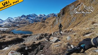
trail: Maighels-Pass
6:37 |
56 |
Oct 20, 2025 , Andermatt
youtuber
![Pass Maighels @disentissedrun6901]()
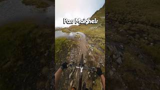
trail: Maighels-Pass
0:44 |
40 |
Sep 18, 2025 , Andermatt
youtuber
![flow is found in the challenge]()
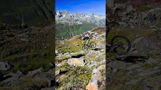
trail: Gatscholalücke
0:12 |
69 |
Sep 9, 2025 , Andermatt
Recent Trail Reports
| status | trail | date | condition | info | user |
|---|---|---|---|---|---|
| Lochbergegg | Jun 22, 2026 @ 6:08am (Europe/Zurich) 1 day | Dry | luminal101 | ||
| Rientalalp | Jun 21, 2026 @ 6:31pm (Europe/Zurich) 2 days | Dry | luminal101 | ||
| Urseren Höhenweg | Jun 20, 2026 @ 10:36am (Europe/Zurich) Jun 20, 2026 | Dry | ManuTu | ||
| Nätschen | Dec 24, 2025 @ 1:18pm (Europe/Zurich) Dec 24, 2025 | Snow Covered | Baery90 | ||
| Unteralptrail | Oct 18, 2025 @ 9:38am (Europe/Zurich) Oct 18, 2025 | Variable | mlu5252 | ||
| Maighels-Pass | Oct 18, 2025 @ 9:38am (Europe/Zurich) Oct 18, 2025 | Variable | mlu5252 | ||
| Oberalpsee | Oct 18, 2025 @ 9:38am (Europe/Zurich) Oct 18, 2025 | Ideal | mlu5252 | ||
| Schöni | Sep 8, 2025 @ 9:49am (Europe/Zurich) Sep 8, 2025 | Ideal | retosedrun | ||
| Lakeside | Sep 8, 2025 @ 9:49am (Europe/Zurich) Sep 8, 2025 | Ideal | retosedrun | ||
| Gotthardtrail II | Sep 8, 2025 @ 8:09am Sep 8, 2025 | Ideal | blaze-j |
National Scenic Trails & Official Routes
-
St.-Gotthard Fünf-Pässe Bike #85
- Mountain Bike
- E-Bike
-
St.-Gotthard Vier-Pässe Bike #84
- Mountain Bike
- E-Bike
Activity Feed
| username | action | type | title | date |
|---|---|---|---|---|
| luminal101 | add | report | activity #97541565 | Jun 21, 2026 @ 9:08pm 1 day |
| luminal101 | add | report | activity #97493245 | Jun 21, 2026 @ 9:31am 2 days |
| luminal101 | ridden | trail | activity #97493020 | Jun 21, 2026 @ 9:28am 2 days |
| ManuTu | add | report | activity #97418540 | Jun 20, 2026 @ 11:44am 3 days |
| ChrisChanT | ridden | trail | activity #97260532 and 2 more | Jun 18, 2026 @ 10:14am Jun 18, 2026 |
Recent Comments
| username | type | title | comment | date |
|---|---|---|---|---|
| trail | The trail offers great scenery and is... | Oct 20, 2025 @ 10:49pm Oct 20, 2025 | ||
| trail | The trail should be rated black, not red. It... | Sep 14, 2025 @ 2:51pm Sep 14, 2025 | ||
| trail | Yes it is rideable for expert riders only. | Sep 6, 2025 @ 9:13am Sep 6, 2025 | ||
| trail | This guy has now ridden it. Except of 2x 50 m... | Sep 6, 2025 @ 9:12am Sep 6, 2025 | ||
| trail | hike primary, black severe diffculty,... | Aug 15, 2025 @ 1:42am Aug 15, 2025 |
Local Badges
-

Epic Mountain Bike Climb 2k6 awarded -

Climbing 10k Badge1 awarded -

Mountain Biking 100k Badge0 awarded -

Epic Ride Descent 2k6 awarded -

Descent 10k Badge1 awarded -

Descent 100k Badge0 awarded
Activity Type Stats
| activitytype | trails | distance | descent | descent distance | total vertical | rating | global rank | state rank | photos | reports | routes | ridelogs |
|---|---|---|---|---|---|---|---|---|---|---|---|---|
| Mountain Bike | 25 | 45 miles | 24,843 ft | 33 miles | 5,230 ft | #3,818 | #68 | 52 | 96 | 2 | 783 | |
| E-Bike | 24 | 43 miles | 24,295 ft | 32 miles | 5,230 ft | #2,503 | #92 | 89 | 4 | 50 | ||
| Hike | 27 | 48 miles | 27,762 ft | 37 miles | 5,230 ft | #3,590 | #67 | 96 | 213 | |||
| Trail Running | 27 | 48 miles | 27,762 ft | 37 miles | 5,230 ft | #3,231 | #58 | 96 | 21 |
Frequently Asked Questions About Andermatt
▼
What are the best places to ride in Andermatt?
Andermatt has 1 areas to explore for mountain biking. The top rated areas are:
▼
What are the highest rated mountain biking trails in Andermatt?
The highest rated mountain biking trails in Andermatt are:
- Lakeside (4.2/5)
- Maighels-Pass (4.2/5)
- Urseren Höhenweg lll (4.1/5)
- Rossmettlen (4.1/5)
- Urseren Höhenweg (4.1/5)
▼
What is the best time of the year to ride in Andermatt?
Based on ride log data, the most popular months to ride in Andermatt are:
- July (5 activities)
- September (4 activities)
- August (3 activities)
▼
Where can I park to ride in Andermatt?
There are 1 parking locations listed in Andermatt. The most popular parking spots are:
Activities
Trails
- By inversedotch
 & contributors
 - Admins: apply
- #29255 - 4,898 views
- andermatt activity log | embed map of Andermatt mountain bike trails | andermatt mountain biking points of interest
Downloading of trail gps tracks in kml & gpx formats is enabled for Andermatt.
You must login to download files.