close
-
Layers w
- Weather Layers
- Pro
- Pro
- Pro
- Pro
- Pro
- Pro
- More Layers
- Pro
- Pro
- Pro
- Pro
-
Upgrade to

3D
Trail Conditions
- Unknown
- Snow Groomed
- Snow Packed
- Snow Covered
- Snow Cover Partial
- Freeze/thaw Cycle
- Icy
- Prevalent Mud
- Wet
- Variable
- Ideal
- Dry
- Very Dry
Trail Flow (Ridden Direction)
Trailforks scans users ridelogs to determine the most popular direction each trail is ridden. A good flowing trail network will have most trails flowing in a single direction according to their intension.
The colour categories are based on what percentage of riders are riding a trail in its intended direction.
The colour categories are based on what percentage of riders are riding a trail in its intended direction.
- > 96%
- > 90%
- > 80%
- > 70%
- > 50%
- < 50%
- bi-directional trail
- no data
Trail Last Ridden
Trailforks scans ridelogs to determine the last time a trail was ridden.
- < 2 days
- < 1 week
- < 2 weeks
- < 1 month
- < 6 months
- > 6 months
Trail Ridden Direction
The intended direction a trail should be ridden.
- Downhill Only
- Downhill Primary
- Both Directions
- Uphill Primary
- Uphill Only
- One Direction
Contribute Details
Colors indicate trail is missing specified detail.
- Description
- Photos
- Description & Photos
- Videos
Trail Popularity ?
Trailforks scans ridelogs to determine which trails are ridden the most in the last 9 months.
Trails are compared with nearby trails in the same city region with a possible 25 colour shades.
Think of this as a heatmap, more rides = more kinetic energy = warmer colors.
- most popular
- popular
- less popular
- not popular
ATV/ORV/OHV Filter
Max Vehicle Width
inches
US Cell Coverage
Legend

Radar Time
Activity Recordings
Trailforks uses anonymized public activity data.
?
Activity Recordings
Trailforks uses anonymized public activity data.
?
Personal Heatmap
▶
Activity Types
all
/
none
▶
Options
2
Date range
month
–
Winter Trails
Warning
A routing network for winter maps does not exist. Selecting trails using the winter trails layer has been disabled.
Missing Trails
Most Popular
Least Popular
Trails are colored based on popularity. The more popular a trail is, the more red. Less popular trails trend towards green.
Jump Magnitude Heatmap
Heatmap of where riders jump on trails. Zoom in to see individual jumps, click circles to view jump details.
BC Backroad Status
![map legend]()
Service Road Atlas is a free to use, community-driven service for viewing and creating reports on the numerous back-country service roads around B.C. and Alberta.

Slope Aspect
Direction the slope faces
Trails Deemphasized
Trails are shown in grey.
Only show trails with no bike usage.
Suggested Layers
Based on selected activity type
Save the current map location and zoom level as your default home location whenever this page is loaded.
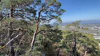
SaveAnnecy area is a idyllic place for riding and living. the lake provide a great view on all the balcony trail around, but also a climate allowing to ride almost ll year long. The city is friendly and not too big, with great restaurant and chill vibes. the Aravis range and La Clusaz resort nearby can provide some alpine riding and epic moment.
La région d'Annecy est un endroit idyllique pour rouler et pour y vivre. Le lac offre une vue magnifique sur tout le sentier en balcon aux alentours, mais aussi un climat permettant de rouler presque toute l'année. La ville est conviviale et pas trop grande, avec d'excellents restaurants et une ambiance décontractée. la chaîne des Aravis et la station de La Clusaz à proximité peuvent offrir des sorties de type montagne. A vous d'explorer
La région d'Annecy est un endroit idyllique pour rouler et pour y vivre. Le lac offre une vue magnifique sur tout le sentier en balcon aux alentours, mais aussi un climat permettant de rouler presque toute l'année. La ville est conviviale et pas trop grande, avec d'excellents restaurants et une ambiance décontractée. la chaîne des Aravis et la station de La Clusaz à proximité peuvent offrir des sorties de type montagne. A vous d'explorer
This region uses the Uk/Euro style trail grading system.
Activities Click to view
- Mountain Bike
297 trails
- E-Bike
321 trails
- Gravel Bike
2 trails
- Adaptive Bike
20 trails
- Winter Fat Bike
12 trails
- Horse
14 trails
- Hike
272 trails
- Trail Running
273 trails
- Dirtbike/Moto
10 trails
- Observed Trials
0 trails
- ATV/ORV/OHV
7 trails
- Snowshoe
11 trails
- Downhill Ski
12 trails
- Nordic Ski
11 trails
Region Details
- 90
- 36
- 76
- 62
- 30
- 2
Region Status
Open as of 2 daysStats
- Avg Trail Rating
- Trails (view details)
- 320
- Trails Mountain Bike
- 297
- Trails E-Bike
- 321
- Trails Gravel Bike
- 2
- Trails Adaptive Bike
- 20
- Trails Winter Fat Bike
- 12
- Trails Horse
- 14
- Trails Hike
- 272
- Trails Trail Running
- 273
- Trails Dirtbike/Moto
- 10
- Trails ATV/ORV/OHV
- 7
- Trails Snowshoe
- 11
- Trails Downhill Ski
- 12
- Trails Backcountry Ski
- 1
- Trails Nordic Ski
- 11
- Total Distance
- 200 miles
- Total Descent Distance
- 96 miles
- Total Descent
- 63,165 ft
- Total Vertical
- 6,004 ft
- Highest Trailhead
- 7,427 ft
- Reports
- 1,502
- Photos
- 192
- Ridden Counter
- 26,208
Sub Regions
-
Le Semnoz
- 12
- 56
- 27
- 8
- 1
-
Les Monts de Veyrier
- 1
- 1
- 12
- 16
- 9
- 2
-
Machurettes/Mandallaz
- 19
- 11
- 10
-
Montagne d'age
- 1
- 1
-
Semnoz Bikepark
- 1
- 1
- 4
Popular Annecy Mountain Biking Trails
• 100 ★ 4.0 • 449 ft • 6 ft • 387 •
Nice short singletrack with one jumps and roots Jolie petit singletrack avec un saut et des racines
• 100 ★ 4.0 • 591 ft • 0 ft • 341 •
Nice singletrack in the woods Jolie singletrack dans les bois
• 100 ★ 4.0 • 636 ft • 0 ft • 273 •
Short singletrack, you can do climb or downhill, first part singletrack and then gravel road Petit singletrack, possible de le faire à la montée et à la descente. Premiére partie en singletrack et en suite chemin 4x4
• 100 ★ 4.0 • 1,027 ft • 0 ft • 199 •
Descente courte mais très simpatique. Elle est shappé avec des berms et des sauts.
• 100 ★ 4.0 • 558 ft • 0 ft • 192 •
Nice singletrack in the woods Jolie singletrack dans les bois
• 90 ★ 4.4 • 2,487 ft • 0 ft • 192 •
Very nice singletrack with some rocky parts and some climbs but nice downhill Jolie singletrack avec des parties en cailloux et quelques remontées
• 90 ★ 4.0 • 2,523 ft • 6 ft • 180 •
Very nice singletrack with some rocky parts and some climbs but nice downhill Jolie singletrack avec des parties en cailloux et quelques remontées
• 95 ★ 5.0 • 2,936 ft • 0 ft • 174 •
Nice classic singletrack in the semnoz, rocks and roots ! Jolie singletrack, classique du semnoz avec des racines et des cailloux !
Annecy Mountain Bike Routes
★ 3.7 • 8 miles • 2,360 ft • 4 • Loop •
Start of the town of Dingy Saint Clair in the parking lot in the midlle of the village (PARKING DINGY...
★ 5.0 • 8 miles • 1,576 ft • 5 • Loop •
Nice little loop with two of the classic downhill in les machurettes ! One climb on the road and another...
★ 5.0 • 3 miles • 745 ft • 4 • Loop •
Little tour in les machurettes with a climb on the road and on gravel road. With a nice downhill. Jolie...
★ 5.0 • 23 miles • 989 ft • 87 • Loop •
Il s’agit de l’une des plus belles randonnées à vélo de France, ne serait-ce qu’à cause de la...
21 miles • 3,712 ft • 3 • Loop •
One of the many, many possible loops on Semnoz. This one alternates between road and trail for climbing....
Photos of Annecy Mountain Bike
Videos of Annecy Mountain Bike
trail: L'inconnue
0:06 |
120 |
Jun 12, 2024
0:20 |
150 |
Apr 25, 2022
trail: Sentier de la crête
0:14 |
136 |
Apr 25, 2022
trail: Enduro Machurettes Haut
0:06 |
150 |
Jun 24, 2021
trail: Segment 3 Semnoz
11:30 |
321 |
Apr 26, 2021
0:11 |
|
Apr 16, 2021
trail: La descente des sources
0:44 |
293 |
Oct 25, 2020
trail: La descente des sources
0:05 |
135 |
Aug 25, 2020
Current Trail Warnings
| status | trail | date | condition | user | info |
|---|---|---|---|---|---|
| La Petite Descente Machu | May 29, 2026 @ 3:32pm (Europe/Paris) May 29, 2026 | Unknown | dsfsdNueSYa | E-Bike Parcours fermé travaux en cours |
Recent Trail Reports
| status | trail | date | condition | info | user |
|---|---|---|---|---|---|
| L'inconnue variante | Jun 24, 2026 @ 1:05pm (Europe/Zurich) 2 days | Ideal | crank2drop ACC | ||
| L'inconnue | Jun 24, 2026 @ 1:05pm (Europe/Zurich) 2 days | Ideal | crank2drop ACC | ||
| Piste Rouge Bas | Jun 20, 2026 @ 4:16pm (Europe/Monaco) Jun 20, 2026 | Dry | crank2drop ACC | ||
| Piste Rouge Haut | Jun 20, 2026 @ 4:16pm (Europe/Monaco) Jun 20, 2026 | Dry | crank2drop ACC | ||
| Nouvelle Rouge Bas | Jun 20, 2026 @ 4:16pm (Europe/Monaco) Jun 20, 2026 | Dry | crank2drop ACC | ||
| Nouvelle Rouge Haut | Jun 20, 2026 @ 4:16pm (Europe/Monaco) Jun 20, 2026 | Dry | crank2drop ACC | ||
| Piste Bleue | Jun 20, 2026 @ 4:16pm (Europe/Monaco) Jun 20, 2026 | Dry | crank2drop ACC | ||
| Les tennis | Jun 10, 2026 @ 12:25pm (Europe/Zurich) Jun 10, 2026 | Ideal | crank2drop ACC | ||
| Les Tennis 2 | Jun 10, 2026 @ 12:25pm (Europe/Zurich) Jun 10, 2026 | Ideal | crank2drop ACC | ||
| Corniche singletrack | Jun 10, 2026 @ 12:25pm (Europe/Zurich) Jun 10, 2026 | Ideal | crank2drop ACC |
Activity Feed
| username | action | type | title | date |
|---|---|---|---|---|
| crank2drop | add | report | activity #97696487 and 1 more | Jun 24, 2026 @ 7:35am 2 days |
| crank2drop | wishlist | trail | activity #97562290 | Jun 22, 2026 @ 8:03am Jun 22, 2026 |
| crank2drop | update | region | activity #97555852 | Jun 22, 2026 @ 5:50am Jun 22, 2026 |
| crank2drop | add | report | activity #97416305 and 4 more | Jun 20, 2026 @ 11:22am Jun 20, 2026 |
| JLq1fN | vote | route | activity #97375272 | Jun 20, 2026 @ 2:36am Jun 20, 2026 |
Recent Comments
| username | type | title | comment | date |
|---|---|---|---|---|
| trail | Magnifique en montée. du challenge technique... | May 27, 2026 @ 2:08am May 27, 2026 | ||
| trail | Pratique pour ne pas remonter par la route! | Jan 2, 2026 @ 12:21am Jan 2, 2026 | ||
| trail | Piste super fun, technique avec quelques relances. | Oct 31, 2025 @ 10:26am Oct 31, 2025 | ||
| trail | Un peu court mais super fun :) | Oct 31, 2025 @ 10:24am Oct 31, 2025 | ||
| trail | XC type, pedestrian trail, not that fun to ride | Oct 25, 2025 @ 8:39am Oct 25, 2025 |
Local Badges
-

10 Red Trails8 awarded -

10 Black Trails4 awarded -
10 Green Trails4 awarded -

Completionist0 awarded -

Completionist0 awarded -
Completionist0 awarded
Bike & Skill Parks
| name | type | city | rating |
|---|---|---|---|
| Semnoz Bikepark | bike park | Annecy | |
| Pumptrack Argonay | skill park | Annecy | |
| Bicross Cran-Gevrier | skill park | Annecy | |
| pumptrack Lucinge | skill park | Annecy | |
| Skatepark de Cran | skill park | Annecy |
Upcoming Local Events
Activity Type Stats
| activitytype | trails | distance | descent | descent distance | total vertical | rating | global rank | state rank | photos | reports | routes | ridelogs |
|---|---|---|---|---|---|---|---|---|---|---|---|---|
| Mountain Bike | 297 | 183 miles | 58,494 ft | 88 miles | 4,124 ft | #354 | #2 | 189 | 1,502 | 13 | 15,045 | |
| E-Bike | 321 | 200 miles | 63,166 ft | 96 miles | 6,004 ft | #123 | #33 | 1,476 | 6 | 1,384 | ||
| Gravel Bike | 2 | 2,635 ft | 46 ft | 577 ft | 646 ft | #73 | #36 | 40 | 28 | |||
| Adaptive Bike | 20 | 24 miles | 2,044 ft | 6 miles | 2,169 ft | #31 | #70 | 140 | ||||
| Winter Fat Bike | 12 | 13 miles | 4,636 ft | 7 miles | 2,740 ft | #32 | #32 | 9 | ||||
| Horse | 14 | 11 miles | 715 ft | 3 miles | 2,044 ft | #185 | #20 | 23 | ||||
| Hike | 272 | 168 miles | 51,818 ft | 79 miles | 4,052 ft | #397 | #15 | 1,482 | 2 | 771 | ||
| Trail Running | 273 | 169 miles | 52,165 ft | 79 miles | 4,052 ft | #275 | #15 | 1,482 | 2 | 2,073 | ||
| Dirtbike/Moto | 10 | 19 miles | 751 ft | 4 miles | 2,034 ft | #152 | #7 | 23 | 11 | |||
| ATV/ORV/OHV | 7 | 7 miles | 594 ft | 2 miles | 1,926 ft | #86 | #7 | 23 | ||||
| Snowshoe | 11 | 8 miles | 837 ft | 3 miles | 571 ft | #49 | #6 | 5 | ||||
| Downhill Ski | 12 | 6 miles | 3,835 ft | 5 miles | 909 ft | #166 | #27 | 81 | ||||
| Backcountry Ski | 1 | 3 miles | 4,373 ft | 115 | ||||||||
| Nordic Ski | 11 | 8 miles | 837 ft | 3 miles | 571 ft | #84 | #8 | 87 |
Frequently Asked Questions About Annecy
▼
What are the best places to ride in Annecy?
Annecy has 7 areas to explore for mountain biking. The top rated areas are:
▼
What are the highest rated mountain biking trails in Annecy?
The highest rated mountain biking trails in Annecy are:
- Est roller coaster (4.4/5)
- L'inconnue (4.3/5)
- Gouletas (4.3/5)
- La descente des sources (4.3/5)
- Sous chapeau napoléon -> Annecy le vieux (4.3/5)
▼
What is the best time of the year to ride in Annecy?
Based on ride log data, the most popular months to ride in Annecy are:
- October (63 activities)
- September (51 activities)
- August (48 activities)
▼
Where can I park to ride in Annecy?
There are 24 parking locations listed in Annecy. The most popular parking spots are:
- Parking confidence
- Parking carrefour quintal
- Parking les Airelles
- Parking des puisots
- Parking parc animalier
Activities
- Annecy Mountain Biking Trails
- Annecy E-Biking Trails
- Annecy Adaptive Biking Trails
- Annecy Winter Fat Biking Trails
- Annecy Horseback Trails
- Annecy Hiking Trails
- Annecy Trail Running Trails
- Annecy Dirtbiking Trails
- Annecy ATVing/Offroading Trails
- Annecy Snowshoeing Trails
- Annecy Skiing Trails
- Annecy Nordic Skiing Trails
Trails
- By TitoTomasi
 & contributors
 - Admins: alltta, freerider48, maxlatourte, Charliedp, Whipperman, ACC, freerider48
- #9392 - 39,670 views
- annecy activity log | embed map of Annecy mountain bike trails | annecy mountain biking points of interest polygons
Downloading of trail gps tracks in kml & gpx formats is enabled for Annecy.
You must login to download files.