close
-
Layers w
- Weather Layers
- Pro
- Pro
- Pro
- Pro
- Pro
- Pro
- More Layers
- Pro
- Pro
- Pro
- Pro
-
Upgrade to

3D
Trail Conditions
- Unknown
- Snow Groomed
- Snow Packed
- Snow Covered
- Snow Cover Partial
- Freeze/thaw Cycle
- Icy
- Prevalent Mud
- Wet
- Variable
- Ideal
- Dry
- Very Dry
Trail Flow (Ridden Direction)
Trailforks scans users ridelogs to determine the most popular direction each trail is ridden. A good flowing trail network will have most trails flowing in a single direction according to their intension.
The colour categories are based on what percentage of riders are riding a trail in its intended direction.
The colour categories are based on what percentage of riders are riding a trail in its intended direction.
- > 96%
- > 90%
- > 80%
- > 70%
- > 50%
- < 50%
- bi-directional trail
- no data
Trail Last Ridden
Trailforks scans ridelogs to determine the last time a trail was ridden.
- < 2 days
- < 1 week
- < 2 weeks
- < 1 month
- < 6 months
- > 6 months
Trail Ridden Direction
The intended direction a trail should be ridden.
- Downhill Only
- Downhill Primary
- Both Directions
- Uphill Primary
- Uphill Only
- One Direction
Contribute Details
Colors indicate trail is missing specified detail.
- Description
- Photos
- Description & Photos
- Videos
Trail Popularity ?
Trailforks scans ridelogs to determine which trails are ridden the most in the last 9 months.
Trails are compared with nearby trails in the same city region with a possible 25 colour shades.
Think of this as a heatmap, more rides = more kinetic energy = warmer colors.
- most popular
- popular
- less popular
- not popular
ATV/ORV/OHV Filter
Max Vehicle Width
inches
US Cell Coverage
Legend

Radar Time
Activity Recordings
Trailforks uses anonymized public activity data.
?
Activity Recordings
Trailforks uses anonymized public activity data.
?
Personal Heatmap
▶
Activity Types
all
/
none
▶
Options
2
Date range
month
–
Winter Trails
Warning
A routing network for winter maps does not exist. Selecting trails using the winter trails layer has been disabled.
Missing Trails
Most Popular
Least Popular
Trails are colored based on popularity. The more popular a trail is, the more red. Less popular trails trend towards green.
Jump Magnitude Heatmap
Heatmap of where riders jump on trails. Zoom in to see individual jumps, click circles to view jump details.
BC Backroad Status
![map legend]()
Service Road Atlas is a free to use, community-driven service for viewing and creating reports on the numerous back-country service roads around B.C. and Alberta.

Slope Aspect
Direction the slope faces
Trails Deemphasized
Trails are shown in grey.
Only show trails with no bike usage.
Suggested Layers
Based on selected activity type
Save the current map location and zoom level as your default home location whenever this page is loaded.
Save
No description for Appin has been added yet!
Login or register to submit one.
Activities Click to view
- Mountain Bike
10 trails
- Gravel Bike
0 trails
- Adaptive Bike
0 trails
- Hike
9 trails
- Trail Running
9 trails
Region Details
- 8
- 1
- 1
Region Status
Open as of May 19, 2025Stats
- Avg Trail Rating
- Trails (view details)
- 10
- Trails Mountain Bike
- 10
- Trails E-Bike
- 1
- Trails Hike
- 9
- Trails Trail Running
- 9
- Total Distance
- 31 miles
- Total Descent
- 3,019 ft
- Total Vertical
- 757 ft
- Highest Trailhead
- 1,449 ft
- Reports
- 53
- Photos
- 58
- Ridden Counter
- 326
Sub Regions
-
Dharawal National Park
- 1
- 1
Popular Appin Mountain Biking Trails
• 100 ★ 3.0 • 8 miles • 671 ft • 67 •
XC single trail with some technical features to negotiate. Best suited for Intermediate levels of fitness and skills.
• 90 ★ 0.0 • 3 miles • 337 ft • 52 •
Branches off 10B trail - is the linking trail to get to Darkes Forest. Fire trail with steep descent down to river crossing (concrete causeway - usually about 100mm deep) & then steep climb up to 10H trail. Typical loose sandstone fire...
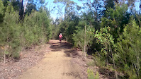
Photos of Appin Mountain Bike
Videos of Appin Mountain Bike
0:12 |
243 |
Jan 29, 2016
Recent Trail Reports
| status | trail | date | condition | info | user |
|---|---|---|---|---|---|
| Appin | Aug 25, 2024 @ 2:20pm Aug 25, 2024 | Dry | Trav1 | ||
| Dharawal 10R Management Trail | Nov 11, 2022 @ 10:53am Nov 11, 2022 | Variable | kdellow | ||
| Dharawal 10U Management Trail | Nov 11, 2022 @ 10:53am Nov 11, 2022 | Variable | kdellow | ||
| Dharawal 10C Management Trail | Nov 11, 2022 @ 10:53am Nov 11, 2022 | Variable | kdellow | ||
| Dharawal 10H Management Trail | Nov 11, 2022 @ 10:53am Nov 11, 2022 | Variable | kdellow | ||
| Dharawal 10D Management Trail | Nov 11, 2022 @ 10:53am Nov 11, 2022 | Variable | kdellow | ||
| Dharawal 10B Management Trail | Nov 11, 2022 @ 10:53am Nov 11, 2022 | Variable | kdellow | ||
| Dharawal 10P Management Trail | Nov 11, 2022 @ 6:53pm Nov 11, 2022 | Variable | kdellow |
Activity Feed
| username | action | type | title | date |
|---|---|---|---|---|
| joelbailey3 | wishlist | trail | activity #95160168 | May 21, 2026 @ 12:45am May 21, 2026 |
| Joshua3yHMqS | ridden | trail | activity #90250168 | Mar 8, 2026 @ 9:00pm Mar 8, 2026 |
| Joshua3yHMqS | ridden | trail | activity #88364196 | Feb 4, 2026 @ 11:34pm Feb 4, 2026 |
| MalcolmQ7LcOv | ridden | trail | activity #86882915 | Jan 8, 2026 @ 10:31pm Jan 8, 2026 |
| willywonka2012 | ridden | trail | activity #83945154 | Nov 10, 2025 @ 8:53pm Nov 10, 2025 |
Recent Comments
| username | type | title | comment | date |
|---|---|---|---|---|
| trail | With the recent high rainfall in August... | Oct 13, 2025 @ 3:28pm Oct 13, 2025 | ||
| trail | Wet in places, quite a bit of wet sand and a... | Oct 20, 2024 @ 1:58am Oct 20, 2024 | ||
| trail | These are fun XC style trails with some nice... | May 19, 2024 @ 2:48am May 19, 2024 | ||
| trail | Some sections have not been riden for a while,... | Jan 19, 2024 @ 5:48pm Jan 19, 2024 | ||
| trail | Trail in bad shape. Lots of erosion and rutted... | May 3, 2023 @ 2:14am May 3, 2023 |
Activity Type Stats
| activitytype | trails | distance | descent | descent distance | total vertical | rating | global rank | state rank | photos | reports | routes | ridelogs |
|---|---|---|---|---|---|---|---|---|---|---|---|---|
| Mountain Bike | 10 | 31 miles | 3,018 ft | 13 miles | 758 ft | #7,137 | #236 | 58 | 53 | 1,294 | ||
| E-Bike | 1 | 8 miles | 673 ft | 3 miles | 180 ft | 24 | 258 | |||||
| Hike | 9 | 23 miles | 2,346 ft | 9 miles | 758 ft | #7,101 | #218 | 42 | 30 | |||
| Trail Running | 9 | 23 miles | 2,346 ft | 9 miles | 758 ft | #6,528 | #206 | 42 | 26 |
Frequently Asked Questions About Appin
▼
What are the best places to ride in Appin?
Appin has 1 areas to explore for mountain biking. The top rated areas are:
▼
What are the highest rated mountain biking trails in Appin?
The highest rated mountain biking trails in Appin are:
- Appin (3.8/5)
- Dharawal 10C Management Trail (0/5)
▼
What is the best time of the year to ride in Appin?
Based on ride log data, the most popular months to ride in Appin are:
- October (6 activities)
- June (6 activities)
- May (5 activities)
▼
Where can I park to ride in Appin?
- By pinadog & contributors
- Admins: stuartrichardson, WMMBC, TrailCare
- #13017 - 6,089 views
- appin activity log | embed map of Appin mountain bike trails | appin mountain biking points of interest
Downloading of trail gps tracks in kml & gpx formats is enabled for Appin.
You must login to download files.