close
-
Layers w
- Weather Layers
- Pro
- Pro
- Pro
- Pro
- Pro
- Pro
- More Layers
- Pro
- Pro
- Pro
- Pro
-
Upgrade to

3D
Trail Conditions
- Unknown
- Snow Groomed
- Snow Packed
- Snow Covered
- Snow Cover Partial
- Freeze/thaw Cycle
- Icy
- Prevalent Mud
- Wet
- Variable
- Ideal
- Dry
- Very Dry
Trail Flow (Ridden Direction)
Trailforks scans users ridelogs to determine the most popular direction each trail is ridden. A good flowing trail network will have most trails flowing in a single direction according to their intension.
The colour categories are based on what percentage of riders are riding a trail in its intended direction.
The colour categories are based on what percentage of riders are riding a trail in its intended direction.
- > 96%
- > 90%
- > 80%
- > 70%
- > 50%
- < 50%
- bi-directional trail
- no data
Trail Last Ridden
Trailforks scans ridelogs to determine the last time a trail was ridden.
- < 2 days
- < 1 week
- < 2 weeks
- < 1 month
- < 6 months
- > 6 months
Trail Ridden Direction
The intended direction a trail should be ridden.
- Downhill Only
- Downhill Primary
- Both Directions
- Uphill Primary
- Uphill Only
- One Direction
Contribute Details
Colors indicate trail is missing specified detail.
- Description
- Photos
- Description & Photos
- Videos
Trail Popularity ?
Trailforks scans ridelogs to determine which trails are ridden the most in the last 9 months.
Trails are compared with nearby trails in the same city region with a possible 25 colour shades.
Think of this as a heatmap, more rides = more kinetic energy = warmer colors.
- most popular
- popular
- less popular
- not popular
ATV/ORV/OHV Filter
Max Vehicle Width
inches
US Cell Coverage
Legend

Radar Time
Activity Recordings
Trailforks uses anonymized public activity data.
?
Activity Recordings
Trailforks uses anonymized public activity data.
?
Personal Heatmap
▶
Activity Types
all
/
none
▶
Options
2
Date range
month
–
Winter Trails
Warning
A routing network for winter maps does not exist. Selecting trails using the winter trails layer has been disabled.
Missing Trails
Most Popular
Least Popular
Trails are colored based on popularity. The more popular a trail is, the more red. Less popular trails trend towards green.
Jump Magnitude Heatmap
Heatmap of where riders jump on trails. Zoom in to see individual jumps, click circles to view jump details.
BC Backroad Status
![map legend]()
Service Road Atlas is a free to use, community-driven service for viewing and creating reports on the numerous back-country service roads around B.C. and Alberta.

Slope Aspect
Direction the slope faces
Trails Deemphasized
Trails are shown in grey.
Only show trails with no bike usage.
Suggested Layers
Based on selected activity type
Save the current map location and zoom level as your default home location whenever this page is loaded.
Save
No description for Aprica has been added yet!
Login or register to submit one.
This region uses the Uk/Euro style trail grading system.
Activities Click to view
- Mountain Bike
41 trails
- E-Bike
17 trails
- Adaptive Bike
0 trails
- Winter Fat Bike
1 trails
- Horse
2 trails
- Hike
37 trails
- Trail Running
37 trails
- Dirtbike/Moto
0 trails
- ATV/ORV/OHV
0 trails
- Snowmobile
0 trails
- Snowshoe
2 trails
- Downhill Ski
24 trails
- Nordic Ski
2 trails
Region Details
- 4
- 1
- 9
- 11
- 1
- 1
Region Status
Open as of Jun 14, 2026Stats
- Avg Trail Rating
- Trails (view details)
- 33
- Trails Mountain Bike
- 41
- Trails E-Bike
- 17
- Trails Winter Fat Bike
- 1
- Trails Horse
- 2
- Trails Hike
- 37
- Trails Trail Running
- 37
- Trails Snowshoe
- 2
- Trails Downhill Ski
- 24
- Trails Backcountry Ski
- 1
- Trails Nordic Ski
- 2
- Total Distance
- 54 miles
- Total Descent
- 26,692 ft
- Total Vertical
- 6,347 ft
- Highest Trailhead
- 7,626 ft
- Reports
- 101
- Photos
- 24
- Ridden Counter
- 845
Articles
Course Preview: Evan Medcalf & Camden Rutherford Ride the iXS EDC #4 in Aprica, Italy
Jun 27, 2025 from pinkbike.com
A lap down the brand new track in Aprica.
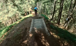
Popular Aprica Mountain Biking Trails
• 100 ★ 4.5 • 2 miles • 28 ft • 31 •
Popular blue difficulty singletrack. This mountain bike primary trail with a 28 ft blue climb. Exposure: Normal Injury Risk. On average it takes 32 minutes to complete this trail.
• 95 ★ 4.0 • 4,350 ft • 19 ft • 30 •
Popular blue difficulty singletrack. This mountain bike primary trail. On average it takes 12 minutes to complete this trail.
• 100 ★ 4.5 • 5,213 ft • 18 ft • 27 •
Popular red difficulty alpine singletrack. This mountain bike primary trail. On average it takes 30 minutes to complete this trail.
• 75 ★ 5.0 • 8 miles • 2,227 ft • 24 •
Single trail at 2000 m with an amazing view on mountains and Belviso lake. Few parts of the path a bit exposed but usually secured by chains (in case of afraid of heights). Low and slow gain of altitude well spread on the distance....
• 90 ★ 0.0 • 2 miles • 2 ft • 22 •
The path starts at the top of the Palabione gondola and descends towards Aprica, through confer forests. The first part is flat, very pleasant and fun: wide bends mean you can enjoy the entire descent but pay attention to draining water...
• 60 ★ 2.0 • 5 miles • 5 ft • 19 •
Not a trail, top part is double track service road, bottom part is an old double track Mulatiero!
• 65 ★ 0.0 • 3,399 ft • 16 ft • 17 •
Nice single track from Passo del Venerocolo to Lago di Belviso. First section quite steep, smooth rocks and typical Alpine path. Then gravel mountain road. All of this in a magic landscape. The trail from the Magnolta (Aprica) ski area...
• 40 ★ 0.0 • 5,239 ft • 169 ft • 15 •
Moderately popular blue difficulty alpine singletrack. This mountain bike primary trail can be used downhill only. On average it takes 11 minutes to complete this trail.
Aprica Mountain Bike Routes
★ 4.0 • 26 miles • 5,971 ft • 2 • Loop •
percorso vario con salite lunghe e impegnative sia su mulattiere e single track, alcuni tratti su asfalto...
21 miles • 3,864 ft • 1 • Loop •
Tour also suitable for beginners to discover the area around Trivigno. You go up from the paved road that...
26 miles • 6,819 ft • 0 • Loop •
Great tour from Aprica, climbing ski area, then long single track with spectacular view and finally...
Photos of Aprica Mountain Bike
Videos of Aprica Mountain Bike
6:21 |
237 |
Feb 1, 2020 , Aprica
Recent Trail Reports
| status | trail | date | condition | info | user |
|---|---|---|---|---|---|
| Pisce trail | Jun 14, 2026 @ 11:13am (Europe/Rome) Jun 14, 2026 | Ideal | DavideDo | ||
| Belvedere | Jun 14, 2026 @ 11:12am (Europe/Rome) Jun 14, 2026 | Ideal | DavideDo | ||
| Alpini trail | Jun 14, 2026 @ 11:12am (Europe/Rome) Jun 14, 2026 | Ideal | DavideDo | ||
| Zapel Natural | Jun 13, 2026 @ 11:13pm (Europe/Rome) Jun 13, 2026 | Ideal | DavideDo | ||
| Aprica - Magnolta | Jun 13, 2026 @ 11:12pm (Europe/Rome) Jun 13, 2026 | Ideal | DavideDo | ||
| Sentiero tematico il legno è vita | Jun 13, 2026 @ 11:12pm (Europe/Rome) Jun 13, 2026 | Ideal | DavideDo | ||
| Palabione Valsorda Flow | Jun 13, 2026 @ 11:12pm (Europe/Rome) Jun 13, 2026 | Ideal | DavideDo | ||
| Magnolta Valsorda | Jun 13, 2026 @ 11:12pm (Europe/Rome) Jun 13, 2026 | Ideal | DavideDo | ||
| Valentina Trail | Jun 13, 2026 @ 11:11pm (Europe/Rome) Jun 13, 2026 | Ideal | DavideDo | ||
| Valentina trail | Jun 13, 2026 @ 11:11pm (Europe/Rome) Jun 13, 2026 | Ideal | DavideDo |
Activity Feed
| username | action | type | title | date |
|---|---|---|---|---|
| DavideDo | add | report | activity #96946239 and 2 more | Jun 14, 2026 @ 2:12am Jun 14, 2026 |
| DavideDo | add | report | activity #96915227 and 9 more | Jun 13, 2026 @ 2:09pm Jun 13, 2026 |
| LucaFontana | add | photo | activity #96565413 and 5 more | Jun 8, 2026 @ 2:54pm Jun 8, 2026 |
| MTBAPRICA | update | directory | activity #96565159 | Jun 8, 2026 @ 2:50pm Jun 8, 2026 |
| LucaFontana | add | skillpark | activity #96556408 | Jun 8, 2026 @ 12:11pm Jun 8, 2026 |
Recent Comments
| username | type | title | comment | date |
|---|---|---|---|---|
| trail | Secondo me questo sentiero starebbe molto... | Jun 1, 2026 @ 4:42am Jun 1, 2026 | ||
| trail | Ciao, inserisci il commento come “trail... | Apr 5, 2026 @ 12:01pm Apr 5, 2026 | ||
| trail | In ottime condizioni, sentiero ben pulito,... | Apr 5, 2026 @ 7:15am Apr 5, 2026 | ||
| trail | Fun trail with roots and rocks with some... | Jun 18, 2022 @ 9:31am Jun 18, 2022 | ||
| report | @karlacio: No, ancora no. Che peccato! L'anno... | Jul 26, 2021 @ 2:17am Jul 26, 2021 |
Local Badges
-

Epic Ride Climb 2k134 awarded -

Climbing 10k Badge16 awarded -

Climbing 100k Badge0 awarded -

Epic Ride Descent 2k146 awarded -

Descent 10k Badge19 awarded -

Descent 100k Badge0 awarded
Bike & Skill Parks
| name | type | city | rating |
|---|---|---|---|
| WILD BIKE PARK | skill park | Aprica |
Activity Type Stats
| activitytype | trails | distance | descent | descent distance | total vertical | rating | global rank | state rank | photos | reports | routes | ridelogs |
|---|---|---|---|---|---|---|---|---|---|---|---|---|
| Mountain Bike | 41 | 54 miles | 26,693 ft | 32 miles | 6,348 ft | #3,308 | #173 | 14 | 76 | 3 | 1,297 | |
| E-Bike | 17 | 19 miles | 6,473 ft | 9 miles | 3,963 ft | #4,275 | #410 | 2 | 37 | 3 | 452 | |
| Winter Fat Bike | 1 | #176 | #253 | 4 | ||||||||
| Horse | 2 | 1 mile | 912 ft | 4,121 ft | 761 ft | #1,969 | #115 | 6 | 1 | |||
| Hike | 37 | 49 miles | 23,632 ft | 29 miles | 6,309 ft | #4,044 | #153 | 3 | 75 | 1 | 194 | |
| Trail Running | 37 | 49 miles | 23,632 ft | 29 miles | 6,309 ft | #3,528 | #136 | 75 | 36 | |||
| Snowshoe | 2 | 1 mile | 912 ft | 4,121 ft | 761 ft | #138 | #6 | 5 | 26 | |||
| Downhill Ski | 24 | #293 | #24 | 25 | 277 | |||||||
| Backcountry Ski | 1 | 1 mile | 791 ft | 5,075 ft | 794 ft | 1 | 89 | |||||
| Nordic Ski | 2 | 1 mile | 912 ft | 4,121 ft | 761 ft | #205 | #1 | 5 | 144 |
Frequently Asked Questions About Aprica
▼
What are the best places to ride in Aprica?
Aprica has 1 areas to explore for mountain biking.
▼
What are the highest rated mountain biking trails in Aprica?
The highest rated mountain biking trails in Aprica are:
- Magnolta - Passo Venerocolo (4.2/5)
- Itinerario per Baite Premalt (4.1/5)
- Galleno (4.1/5)
- Gembro trail (4.1/5)
- Magnolta Valsorda (4.1/5)
▼
What is the best time of the year to ride in Aprica?
Based on ride log data, the most popular months to ride in Aprica are:
- August (17 activities)
- June (12 activities)
- July (5 activities)
▼
Where can I park to ride in Aprica?
Check the Aprica trail map for trailhead and parking information. Community members regularly update access and parking details for trails in the area.
Activities
Trails
Points of Interest
- By MTBAPRICA & contributors
- Admins: marcoangeletti, adessoomaipiu, micheletraversi
- #24879 - 4,798 views
- aprica activity log | embed map of Aprica mountain bike trails |
Downloading of trail gps tracks in kml & gpx formats is enabled for Aprica.
You must login to download files.