close
-
Layers w
- Weather Layers
- Pro
- Pro
- Pro
- Pro
- Pro
- Pro
- More Layers
- Pro
- Pro
- Pro
- Pro
-
Upgrade to

3D
Trail Conditions
- Unknown
- Snow Groomed
- Snow Packed
- Snow Covered
- Snow Cover Partial
- Freeze/thaw Cycle
- Icy
- Prevalent Mud
- Wet
- Variable
- Ideal
- Dry
- Very Dry
Trail Flow (Ridden Direction)
Trailforks scans users ridelogs to determine the most popular direction each trail is ridden. A good flowing trail network will have most trails flowing in a single direction according to their intension.
The colour categories are based on what percentage of riders are riding a trail in its intended direction.
The colour categories are based on what percentage of riders are riding a trail in its intended direction.
- > 96%
- > 90%
- > 80%
- > 70%
- > 50%
- < 50%
- bi-directional trail
- no data
Trail Last Ridden
Trailforks scans ridelogs to determine the last time a trail was ridden.
- < 2 days
- < 1 week
- < 2 weeks
- < 1 month
- < 6 months
- > 6 months
Trail Ridden Direction
The intended direction a trail should be ridden.
- Downhill Only
- Downhill Primary
- Both Directions
- Uphill Primary
- Uphill Only
- One Direction
Contribute Details
Colors indicate trail is missing specified detail.
- Description
- Photos
- Description & Photos
- Videos
Trail Popularity ?
Trailforks scans ridelogs to determine which trails are ridden the most in the last 9 months.
Trails are compared with nearby trails in the same city region with a possible 25 colour shades.
Think of this as a heatmap, more rides = more kinetic energy = warmer colors.
- most popular
- popular
- less popular
- not popular
ATV/ORV/OHV Filter
Max Vehicle Width
inches
US Cell Coverage
Legend

Radar Time
Activity Recordings
Trailforks uses anonymized public activity data.
?
Activity Recordings
Trailforks uses anonymized public activity data.
?
Personal Heatmap
▶
Activity Types
all
/
none
▶
Options
2
Date range
month
–
Winter Trails
Warning
A routing network for winter maps does not exist. Selecting trails using the winter trails layer has been disabled.
Missing Trails
Most Popular
Least Popular
Trails are colored based on popularity. The more popular a trail is, the more red. Less popular trails trend towards green.
Jump Magnitude Heatmap
Heatmap of where riders jump on trails. Zoom in to see individual jumps, click circles to view jump details.
BC Backroad Status
![map legend]()
Service Road Atlas is a free to use, community-driven service for viewing and creating reports on the numerous back-country service roads around B.C. and Alberta.

Slope Aspect
Direction the slope faces
Trails Deemphasized
Trails are shown in grey.
Only show trails with no bike usage.
Suggested Layers
Based on selected activity type
Save the current map location and zoom level as your default home location whenever this page is loaded.
SaveThe C.S. Mott Nature Preserve is a 3,600 acre nature preserve owned by the Grand Traverse Regional Land Conservancy. The Conservancy works hard to balance the public uses offered on their preserves with the protection of nature features, unique habitats, and scenic beauty. The professionally designed (in conjunction with IMBA) single track trail follows contour lines that flow through hills of northern hardwood forest with a few open fields. Here's what local mountain bikers are saying about the Dry Hill and Chestnut Trails at Arcadia Dunes: "great trails with scenic views.", "a roller-coaster, single track thrill ride through the forest.", "sweet flowing single track with some punchy climbs and fast swooping downhills."
FIGURE 8: This 10-mile ride (Chestnut Loop, Dry Hill and Baldy Trails) is a classic no matter which direction you decide to go. The figure 8 is made by the two trails in the Dry Hill area right off the St. Pierre trailhead (Chestnut and Dry Hill loops). If you go such that you can hit the middle of the 8 going south towards Matzinger Rd. you will take in one of the best downhills of the trail system.
QUAD LOOP: There are four basic loops in the Arcadia trail system: The 2-mile loop west of M22, the 2-mile Chestnut loop off the St. Pierre trailhead, the 7-mile Dry Hill Loop and the 2-mile Pete’s Woods loop. Hit all four loops for about a
20-mile ride (7-miles gravel road on top of the loops).
SEASON TIP: If you can only pick one season to ride the loops, it must be spring. When the Trillium wildflowers are in full bloom it is breathtaking to see the hills blanketed with them.
source: SCC Website
Primary Trail Type: Cross-Country
 google parking directions
Links
Activities Click to view
- Mountain Bike
15 trails
- Hike
16 trails
- Trail Running
16 trails
Region Details
- 2
- 3
- 10
Region Status
Open as of Jun 12, 2026Local Trail Association
Stats
- Avg Trail Rating
- Trails (view details)
- 16
- Trails Mountain Bike
- 15
- Trails E-Bike
- 3
- Trails Hike
- 16
- Trails Trail Running
- 16
- Total Distance
- 19 miles
- Total Descent
- 1,502 ft
- Total Vertical
- 383 ft
- Highest Trailhead
- 1,019 ft
- Reports
- 62
- Photos
- 37
- Ridden Counter
- 1,914
Popular Arcadia Dunes Mountain Biking Trails
• 100 ★ 5.0 • 8 miles • 765 ft • 462 •
The C.S. Mott Nature Preserve is a 3,600 acre nature preserve owned by the Grand Traverse Regional Land Conservancy. The Conservancy works hard to balance the public uses offered on their preserves with the protection of nature...
• 95 ★ 0.0 • 280 ft • 9 ft • 310 •
Popular blue difficulty singletrack. This mountain bike primary trail can be used both directions. On average it takes 1 minutes to complete this trail.
• 70 ★ 5.0 • 2 miles • 209 ft • 225 •
The C.S. Mott Nature Preserve is a 3,600 acre nature preserve owned by the Grand Traverse Regional Land Conservancy. The Conservancy works hard to balance the public uses offered on their preserves with the protection of nature...
• 80 ★ 4.0 • 1 mile • 44 ft • 215 •
Easy, family-friendly singletrack ride through a dense hardwood forest...or a fast, fun warmup to the more challenging Chestnut and s in the same area. Well marked. Loop can be ridden in either direction.
• 90 ★ 4.0 • 1 mile • 42 ft • 187 •
Popular green difficulty singletrack. This mountain bike primary trail can be used downhill primary. On average it takes 6 minutes to complete this trail.
• 55 ★ 4.0 • 3 miles • 149 ft • 64 •
The C.S. Mott Nature Preserve is a 3,600 acre nature preserve owned by the Grand Traverse Regional Land Conservancy. The Conservancy works hard to balance the public uses offered on their preserves with the protection of nature...
• 40 ★ 0.0 • 267 ft • 43 ft • 55 •
Moderately popular blue difficulty singletrack. This mountain bike primary trail can be used both directions. On average it takes minutes to complete this trail.
Arcadia Dunes Mountain Bike Routes
9 miles • 801 ft • 1 • Loop •
This is the full starting at the St Pierre Trailhead in the CS Mott Preserve. It includes portions of the .
10 miles • 907 ft • 7 • Loop •
Great sampling of what Arcadia Dunes has to offer: flowy singletrack, punchy climbs, fast downhills. Can...
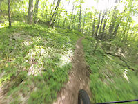
Photos of Arcadia Dunes Mountain Bike
Videos of Arcadia Dunes Mountain Bike
trail: Dry Hill Trail
2:47 |
787 |
May 30, 2014

trail: Dry Hill Trail
6:25 |
911 |
Feb 22, 2022 , Watervale

trail: Chestnut Loop
6:25 |
256 |
Feb 22, 2022 , Watervale
Current Trail Warnings
| status | trail | date | condition | user | info |
|---|---|---|---|---|---|
| Chestnut Loop | Jun 12, 2026 @ 3:35pm (America/Menominee) Jun 12, 2026 | Ideal | rusty10101 | Large tree blocking the downhill section... |
Recent Trail Reports
| status | trail | date | condition | info | user |
|---|---|---|---|---|---|
| Camp Arcadia Trail | Jun 7, 2026 @ 3:58pm (America/Menominee) Jun 7, 2026 | Dry | rusty10101 | ||
| Chestnut Loop | Jun 15, 2025 @ 11:14am Jun 15, 2025 | Ideal | WeeeWooo | ||
| Dry Hill Trail | Jun 15, 2025 @ 11:14am Jun 15, 2025 | Ideal | WeeeWooo | ||
| Camp Arcadia Trails | May 15, 2023 @ 1:28pm May 15, 2023 | Ideal | ericmhunt | ||
| Camp Arcadia Loop | May 15, 2023 @ 1:28pm May 15, 2023 | Ideal | ericmhunt | ||
| Baldy Trail | Sep 29, 2022 @ 1:09pm Sep 29, 2022 | Unknown | Jason5RBM1J | ||
| Baldy Trail Access | Sep 29, 2022 @ 1:09pm Sep 29, 2022 | Unknown | Jason5RBM1J | ||
| Baldy Link 1 | Aug 14, 2022 @ 8:05am Aug 14, 2022 | Dry | linden44 TOMMBA | ||
| Sansan | Apr 25, 2019 @ 12:29am Apr 25, 2019 | Unknown | Naero |
Activity Feed
| username | action | type | title | date |
|---|---|---|---|---|
| rusty10101 | add | report | activity #96829934 | Jun 12, 2026 @ 3:02pm Jun 12, 2026 |
| rusty10101 | add | report | activity #96514656 and 1 more | Jun 7, 2026 @ 6:48pm Jun 7, 2026 |
| flyinghighk9s | wishlist | region | activity #95373181 | May 23, 2026 @ 6:59pm May 23, 2026 |
| Gagliardo1 | wishlist | region | activity #94485633 | May 11, 2026 @ 3:43am May 11, 2026 |
| drbuckdrew | like | report | activity #79337073 | Aug 31, 2025 @ 8:46am Aug 31, 2025 |
Recent Comments
| username | type | title | comment | date |
|---|---|---|---|---|
| trail | Fun XC trail with some flow-like but short... | Aug 8, 2023 @ 7:10pm Aug 8, 2023 | ||
| trail | Nice easy singletrack loop for little shredders. | Jul 7, 2023 @ 9:51am Jul 7, 2023 | ||
| report | Super conditions, trees need to be cleared but... | Oct 7, 2020 @ 11:51am Oct 7, 2020 | ||
| trail | Counterclockwise has more flow and feels like... | Jul 8, 2020 @ 12:30pm Jul 8, 2020 |
Nearby Areas
| name | distance | ||||
|---|---|---|---|---|---|
| Pete's Woods | 3.2 km | ||||
| Green Points Dunes Nature Preserve | 4.4 km | ||||
| Betsie River Pathway | 6 | 7 | 2 | 8.6 km | |
| Crystal Mountain | 4 | 10 | 4 | 10.8 km | |
| Manistee Non-Motorized Trail Park | 1 | 1 | 20.2 km |
Activity Type Stats
| activitytype | trails | distance | descent | descent distance | total vertical | rating | global rank | state rank | photos | reports | routes | ridelogs |
|---|---|---|---|---|---|---|---|---|---|---|---|---|
| Mountain Bike | 15 | 19 miles | 1,490 ft | 6 miles | 384 ft | #5,546 | #2,027 | 37 | 62 | 2 | 1,673 | |
| E-Bike | 3 | 1 mile | 144 ft | 2,818 ft | 131 ft | 49 | 15 | |||||
| Hike | 16 | 19 miles | 1,503 ft | 6 miles | 384 ft | #9,559 | #3,682 | 62 | 1 | 51 | ||
| Trail Running | 16 | 19 miles | 1,503 ft | 6 miles | 384 ft | #8,848 | #3,139 | 62 | 1 | 30 |
Frequently Asked Questions About Arcadia Dunes
▼
What are the highest rated mountain biking trails in Arcadia Dunes?
The highest rated mountain biking trails in Arcadia Dunes are:
- Dry Hill Trail (4.4/5)
- Chestnut Loop (4.2/5)
- Baldy Trail (4/5)
- Camp Arcadia Trails (4/5)
- Camp Arcadia Loop (4/5)
▼
What is the best time of the year to ride in Arcadia Dunes?
Based on ride log data, the most popular months to ride in Arcadia Dunes are:
- July (37 activities)
- August (22 activities)
- September (20 activities)
▼
Where can I park to ride in Arcadia Dunes?
There are 3 parking locations listed in Arcadia Dunes. The most popular parking spots are: View all parking and trailhead locations on the map to plan your visit.
▼
What is the longest trail in Arcadia Dunes?
The longest trail in Arcadia Dunes is Dry Hill Trail at 7.8 miles. View all trails sorted by distance.
Activities
- By markholloway
 Trailforks Map Team & contributors
 - Admins: SCC, NMMBA, SCC
- #11500 - 12,398 views
- arcadia dunes activity log | embed map of Arcadia Dunes mountain bike trails | arcadia dunes mountain biking points of interest
Downloading of trail gps tracks in kml & gpx formats is enabled for Arcadia Dunes.
You must login to download files.