close
-
Layers w
- Weather Layers
- Pro
- Pro
- Pro
- Pro
- Pro
- Pro
- More Layers
- Pro
- Pro
- Pro
- Pro
-
Upgrade to

3D
Trail Conditions
- Unknown
- Snow Groomed
- Snow Packed
- Snow Covered
- Snow Cover Partial
- Freeze/thaw Cycle
- Icy
- Prevalent Mud
- Wet
- Variable
- Ideal
- Dry
- Very Dry
Trail Flow (Ridden Direction)
Trailforks scans users ridelogs to determine the most popular direction each trail is ridden. A good flowing trail network will have most trails flowing in a single direction according to their intension.
The colour categories are based on what percentage of riders are riding a trail in its intended direction.
The colour categories are based on what percentage of riders are riding a trail in its intended direction.
- > 96%
- > 90%
- > 80%
- > 70%
- > 50%
- < 50%
- bi-directional trail
- no data
Trail Last Ridden
Trailforks scans ridelogs to determine the last time a trail was ridden.
- < 2 days
- < 1 week
- < 2 weeks
- < 1 month
- < 6 months
- > 6 months
Trail Ridden Direction
The intended direction a trail should be ridden.
- Downhill Only
- Downhill Primary
- Both Directions
- Uphill Primary
- Uphill Only
- One Direction
Contribute Details
Colors indicate trail is missing specified detail.
- Description
- Photos
- Description & Photos
- Videos
Trail Popularity ?
Trailforks scans ridelogs to determine which trails are ridden the most in the last 9 months.
Trails are compared with nearby trails in the same city region with a possible 25 colour shades.
Think of this as a heatmap, more rides = more kinetic energy = warmer colors.
- most popular
- popular
- less popular
- not popular
ATV/ORV/OHV Filter
Max Vehicle Width
inches
US Cell Coverage
Legend

Radar Time
Activity Recordings
Trailforks uses anonymized public activity data.
?
Activity Recordings
Trailforks uses anonymized public activity data.
?
Personal Heatmap
▶
Activity Types
all
/
none
▶
Options
2
Date range
month
–
Winter Trails
Warning
A routing network for winter maps does not exist. Selecting trails using the winter trails layer has been disabled.
Missing Trails
Most Popular
Least Popular
Trails are colored based on popularity. The more popular a trail is, the more red. Less popular trails trend towards green.
Jump Magnitude Heatmap
Heatmap of where riders jump on trails. Zoom in to see individual jumps, click circles to view jump details.
BC Backroad Status
![map legend]()
Service Road Atlas is a free to use, community-driven service for viewing and creating reports on the numerous back-country service roads around B.C. and Alberta.

Slope Aspect
Direction the slope faces
Trails Deemphasized
Trails are shown in grey.
Only show trails with no bike usage.
Suggested Layers
Based on selected activity type
Save the current map location and zoom level as your default home location whenever this page is loaded.
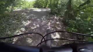
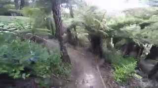
SaveOpened in 2010, these are the closest trails to the CBD (5km riding distance). With over 3km of well maintained trails ranging in grade from “Training Wheels” to the challenging “Steep Street” – there is something for everyone.
source: Arch Hill
Primary Trail Type: Cross-Country
Land Status: City Managed
 google parking directions
Links
Activities Click to view
- Mountain Bike
7 trails
- Hike
1 trails
- Trail Running
1 trails
Stats
- Avg Trail Rating
- Trails (view details)
- 7
- Trails Mountain Bike
- 7
- Trails Hike
- 1
- Trails Trail Running
- 1
- Total Distance
- 1 mile
- Total Descent
- 436 ft
- Total Vertical
- 86 ft
- Highest Trailhead
- 137 ft
- Reports
- 196
- Photos
- 18
- Ridden Counter
- 1,592
Popular Arch Hill Mountain Biking Trails
• 50 ★ 3.5 • 3,291 ft • 218 ft • 261 •
The main trail above the pedestrian trail - all the other trails lead off this one. Generally fairly narrow with a few gentle ups and downs.
• 60 ★ 4.0 • 664 ft • 28 ft • 214 •
Moderately popular blue difficulty singletrack. This mountain bike primary trail can be used one direction. On average it takes minutes to complete this trail.
• 55 ★ 3.2 • 1,358 ft • 28 ft • 200 •
An easy flat trail good for kids and beginners starting out.
• 45 ★ 4.0 • 291 ft • 18 ft • 182 •
Moderately popular blue difficulty singletrack. This mountain bike primary trail can be used one direction. On average it takes minutes to complete this trail.
• 35 ★ 4.5 • 1,604 ft • 50 ft • 161 •
The newest and most technical trail in Arch Hill. Climbing and descending switch backs with rocks and roots. Short rock drop section with a bypass.
• 35 ★ 3.7 • 175 ft • 19 ft • 139 •
Less popular advanced difficulty singletrack. This mountain bike primary trail can be used one direction. On average it takes minutes to complete this trail.
Photos of Arch Hill Mountain Bike
Videos of Arch Hill Mountain Bike
trail: Training Wheels
1361 |
May 22, 2016 , Auckland
trail: Twist and Shout
2179 |
Jul 11, 2015 , Auckland
Recent Trail Reports
| status | trail | date | condition | info | user |
|---|---|---|---|---|---|
| Super Highway | Jan 30, 2025 @ 7:35pm Jan 30, 2025 | Very Dry | campbelln | ||
| Steep Street | Jan 30, 2025 @ 7:35pm Jan 30, 2025 | Dry | campbelln | ||
| Training Wheels | Dec 1, 2024 @ 9:29am Dec 1, 2024 | Wet | catchcam | ||
| Can Of Worms | Mar 10, 2023 @ 7:46pm Mar 10, 2023 | Ideal | ralley | ||
| Twist and Shout | Mar 10, 2023 @ 7:46pm Mar 10, 2023 | Variable | ralley | ||
| Bond Street | Mar 7, 2020 @ 12:14pm Mar 7, 2020 | Dry | ralley |
Activity Feed
| username | action | type | title | date |
|---|---|---|---|---|
| AntonioGarethSP4Ymew | ridden | trail | activity #83945217 | Nov 10, 2025 @ 8:56pm Nov 10, 2025 |
| cambollo | wishlist | region | activity #82500281 | Oct 17, 2025 @ 6:39am Oct 17, 2025 |
| CarlRdluWJ | vote | trail | activity #76785892 | Jul 26, 2025 @ 6:10pm Jul 26, 2025 |
| lintbagger | update | region | activity #72495108 | May 26, 2025 @ 10:58pm May 26, 2025 |
| campbelln | add | report | activity #65406017 and 1 more | Jan 30, 2025 @ 1:12am Jan 30, 2025 |
Recent Comments
| username | type | title | comment | date |
|---|---|---|---|---|
| report | Sadly it was an illegal dumping site for years... | Jan 27, 2024 @ 2:35am Jan 27, 2024 | ||
| trail | Jacinda Arden can build better trails than this | Sep 28, 2021 @ 10:12pm Sep 28, 2021 | ||
| trail | Jacinda Arden can build better trails than this | Sep 28, 2021 @ 10:12pm Sep 28, 2021 | ||
| trail | Jacinda Arden can build better trails than this | Sep 28, 2021 @ 10:12pm Sep 28, 2021 | ||
| trail | Worst trail in the world would rather watch... | Sep 24, 2021 @ 8:02pm Sep 24, 2021 |
Nearby Areas
| name | distance | ||||
|---|---|---|---|---|---|
| Heron Park | 2 | 2.5 km | |||
| Birkenhead Reserve | 4.4 km | ||||
| Birkenhead Domain | 1 | 5.1 km | |||
| Ambury Park | 2 | 4 | 5.6 km | ||
| Waitakere Ranges | 2 | 7.1 km |
Activity Type Stats
| activitytype | trails | distance | descent | descent distance | total vertical | rating | global rank | state rank | photos | reports | routes | ridelogs |
|---|---|---|---|---|---|---|---|---|---|---|---|---|
| Mountain Bike | 7 | 1 mile | 436 ft | 3,281 ft | 85 ft | #5,455 | #120 | 18 | 196 | 25,521 | ||
| Hike | 1 | 1,604 ft | 59 ft | 732 ft | 26 ft | #10,779 | #206 | 164 | 344 | |||
| Trail Running | 1 | 1,604 ft | 59 ft | 732 ft | 26 ft | #9,963 | #189 | 164 | 285 |
Frequently Asked Questions About Arch Hill
▼
What are the highest rated mountain biking trails in Arch Hill?
The highest rated mountain biking trails in Arch Hill are:
- Logan's Run (4.3/5)
- Super Highway (4/5)
- Can Of Worms (4/5)
- Bond Street (3.9/5)
- Steep Street (3.8/5)
▼
What is the best time of the year to ride in Arch Hill?
Based on ride log data, the most popular months to ride in Arch Hill are:
- April (42 activities)
- July (42 activities)
- March (40 activities)
▼
Where can I park to ride in Arch Hill?
There are 2 parking locations listed in Arch Hill. The most popular parking spots are:
▼
What is the longest trail in Arch Hill?
The longest trail in Arch Hill is Twist and Shout at 3,291 ft. View all trails sorted by distance.
- By ralley
 & contributors
 - Admins: AMBC
- #7455 - 11,358 views
- arch hill activity log | embed map of Arch Hill mountain bike trails | arch hill mountain biking points of interest
Downloading of trail gps tracks in kml & gpx formats is enabled for Arch Hill.
You must login to download files.