close
-
Layers w
- Weather Layers
- Pro
- Pro
- Pro
- Pro
- Pro
- Pro
- More Layers
- Pro
- Pro
- Pro
- Pro
-
Upgrade to

3D
Trail Conditions
- Unknown
- Snow Groomed
- Snow Packed
- Snow Covered
- Snow Cover Partial
- Freeze/thaw Cycle
- Icy
- Prevalent Mud
- Wet
- Variable
- Ideal
- Dry
- Very Dry
Trail Flow (Ridden Direction)
Trailforks scans users ridelogs to determine the most popular direction each trail is ridden. A good flowing trail network will have most trails flowing in a single direction according to their intension.
The colour categories are based on what percentage of riders are riding a trail in its intended direction.
The colour categories are based on what percentage of riders are riding a trail in its intended direction.
- > 96%
- > 90%
- > 80%
- > 70%
- > 50%
- < 50%
- bi-directional trail
- no data
Trail Last Ridden
Trailforks scans ridelogs to determine the last time a trail was ridden.
- < 2 days
- < 1 week
- < 2 weeks
- < 1 month
- < 6 months
- > 6 months
Trail Ridden Direction
The intended direction a trail should be ridden.
- Downhill Only
- Downhill Primary
- Both Directions
- Uphill Primary
- Uphill Only
- One Direction
Contribute Details
Colors indicate trail is missing specified detail.
- Description
- Photos
- Description & Photos
- Videos
Trail Popularity ?
Trailforks scans ridelogs to determine which trails are ridden the most in the last 9 months.
Trails are compared with nearby trails in the same city region with a possible 25 colour shades.
Think of this as a heatmap, more rides = more kinetic energy = warmer colors.
- most popular
- popular
- less popular
- not popular
ATV/ORV/OHV Filter
Max Vehicle Width
inches
US Cell Coverage
Legend

Radar Time
Activity Recordings
Trailforks uses anonymized public activity data.
?
Activity Recordings
Trailforks uses anonymized public activity data.
?
Personal Heatmap
▶
Activity Types
all
/
none
▶
Options
2
Date range
month
–
Winter Trails
Warning
A routing network for winter maps does not exist. Selecting trails using the winter trails layer has been disabled.
Missing Trails
Most Popular
Least Popular
Trails are colored based on popularity. The more popular a trail is, the more red. Less popular trails trend towards green.
Jump Magnitude Heatmap
Heatmap of where riders jump on trails. Zoom in to see individual jumps, click circles to view jump details.
BC Backroad Status
![map legend]()
Service Road Atlas is a free to use, community-driven service for viewing and creating reports on the numerous back-country service roads around B.C. and Alberta.

Slope Aspect
Direction the slope faces
Trails Deemphasized
Trails are shown in grey.
Only show trails with no bike usage.
Suggested Layers
Based on selected activity type
Save the current map location and zoom level as your default home location whenever this page is loaded.
Save
No description for Arena Platoş has been added yet!
Login or register to submit one.
 google parking directions
Primary Trail Type: All-Mountain & Downhill
google parking directionsLinks
This region uses the Uk/Euro style trail grading system.
Activities Click to view
- Mountain Bike
9 trails
- E-Bike
6 trails
- Hike
5 trails
- Trail Running
5 trails
Bike Park Details
- 3
- 3
Region Status
Open as of Oct 1, 2025- Day Ticket
- 54 RON
- Uplift Type
- Chair Lift
Stats
- Avg Trail Rating
- Trails (view details)
- 9
- Trails Mountain Bike
- 9
- Trails E-Bike
- 6
- Trails Hike
- 5
- Trails Trail Running
- 5
- Total Distance
- 6 miles
- Total Descent Distance
- 2 miles
- Total Descent
- 1,111 ft
- Total Vertical
- 1,623 ft
- Highest Trailhead
- 4,690 ft
- Reports
- 14
- Ridden Counter
- 238
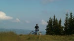
Popular Arena Platoş Mountain Biking Trails
• 50 ★ 5.0 • 2,188 ft • 6 ft • 36 •
Moderately popular green difficulty singletrack. This mountain bike primary trail can be used downhill only and has a easy overall physical rating. It features berm. Trail visibility is always easy to follow. On average it takes 2 minutes to complete this trail.
• 5 ★ 0.0 • 1,181 ft • 0 ft • 17 •
The shortest trail from Arena Platos, being quite straight. Has some natural features.
• 40 ★ 0.0 • 1,703 ft • 0 ft • 13 •
The most difficult trail from Arena Platos, having several drops, huge berms, and a big wallride.
Arena Platoş Mountain Bike Routes
★ 5.0 • 5 miles • 129 ft • 1 • Shuttled •
This trail starts at the top of Oncesti at the Com Tower and goes all the way down to the bottom of the...
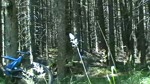
Videos of Arena Platoş Mountain Bike

trail: Paltinis
0:26 |
357 |
Oct 24, 2010
trail: Paltinis
4:09 |
297 |
Aug 17, 2010
trail: Paltinis
3:35 |
178 |
Jul 24, 2010

trail: Paltinis
3:02 |
154 |
Mar 16, 2010

trail: Paltinis
4:20 |
332 |
Feb 4, 2010
trail: Paltinis
2:37 |
118 |
Feb 4, 2010
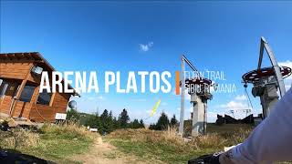
trail: Flow Trail
2:15 |
380 |
Oct 1, 2020 , Rășinari
Recent Trail Reports
| status | trail | date | condition | info | user |
|---|---|---|---|---|---|
| Paltinis | Oct 1, 2025 @ 11:23pm (Europe/Bucharest) Oct 1, 2025 | Variable | Necropolis | ||
| Culmea Comenzii | May 2, 2025 @ 5:11am May 2, 2025 | Ideal | cosminbg | ||
| DF Platos | Aug 17, 2024 @ 4:34pm Aug 17, 2024 | Ideal | andreizr1 | ||
| Flow Trail | Jul 16, 2023 @ 2:59am Jul 16, 2023 | Ideal | zbangee | ||
| DF Schit | Jul 16, 2023 @ 2:59am Jul 16, 2023 | Variable | zbangee | ||
| Access Road to the top of Arena Platos | Jul 16, 2023 @ 2:59am Jul 16, 2023 | Ideal | zbangee | ||
| Downhill Trail | Jul 27, 2021 @ 6:42am Jul 27, 2021 | Dry | pufalot TRAILFORKS |
Activity Feed
| username | action | type | title | date |
|---|---|---|---|---|
| Andewi | difficultyvote | trail | activity #91306653 | Mar 25, 2026 @ 10:42pm Mar 25, 2026 |
| Andewi | ridden | trail | activity #91306530 | Mar 25, 2026 @ 10:34pm Mar 25, 2026 |
| pufalot | update | trail | activity #81526365 | Oct 1, 2025 @ 10:07pm Oct 1, 2025 |
| Necropolis | add | report | activity #81501791 | Oct 1, 2025 @ 1:27pm Oct 1, 2025 |
| pufalot | update | trail | activity #80038048 | Sep 10, 2025 @ 4:14am Sep 10, 2025 |
Nearby Areas
| name | distance | ||||
|---|---|---|---|---|---|
| Obarsia Lotrului | 22.3 km | ||||
| Cozia | 33.4 km |
Activity Type Stats
| activitytype | trails | distance | descent | descent distance | total vertical | rating | global rank | state rank | photos | reports | routes | ridelogs |
|---|---|---|---|---|---|---|---|---|---|---|---|---|
| Mountain Bike | 9 | 6 miles | 1,112 ft | 2 miles | 1,624 ft | #3,446 | #19 | 14 | 3 | 164 | ||
| E-Bike | 6 | 5 miles | 427 ft | 1 mile | 1,624 ft | #1,173 | #9 | 14 | 1 | 24 | ||
| Hike | 5 | 4 miles | 220 ft | 4,177 ft | 1,624 ft | #1,856 | #8 | 14 | 5 | |||
| Trail Running | 5 | 4 miles | 220 ft | 4,177 ft | 1,624 ft | #1,186 | #11 | 14 | 1 |
Frequently Asked Questions About Arena Platoş
▼
What are the highest rated mountain biking trails in Arena Platoş?
The highest rated mountain biking trails in Arena Platoş are:
- Culmea Comenzii (4.3/5)
- Flow Trail (4.1/5)
- Funny Trail (0/5)
- Downhill Trail (0/5)
▼
What is the best time of the year to ride in Arena Platoş?
Based on ride log data, the most popular months to ride in Arena Platoş are:
- August (5 activities)
- June (5 activities)
- July (2 activities)
▼
Where can I park to ride in Arena Platoş?
There are 1 parking locations listed in Arena Platoş. The most popular parking spots are:
▼
What is the longest trail in Arena Platoş?
The longest trail in Arena Platoş is Culmea Comenzii at 1.2 miles. View all trails sorted by distance.
Activities
- By markholloway
 Trailforks Map Team & contributors
 - Admins: ATNS
- #23786 - 3,998 views
- arena platoş activity log | embed map of Arena Platoş mountain bike trails | arena platoş mountain biking points of interest
Downloading of trail gps tracks in kml & gpx formats is enabled for Arena Platoş.
You must login to download files.