close
-
Layers w
- Weather Layers
- Pro
- Pro
- Pro
- Pro
- Pro
- Pro
- More Layers
- Pro
- Pro
- Pro
- Pro
-
Upgrade to

3D
Trail Conditions
- Unknown
- Snow Groomed
- Snow Packed
- Snow Covered
- Snow Cover Partial
- Freeze/thaw Cycle
- Icy
- Prevalent Mud
- Wet
- Variable
- Ideal
- Dry
- Very Dry
Trail Flow (Ridden Direction)
Trailforks scans users ridelogs to determine the most popular direction each trail is ridden. A good flowing trail network will have most trails flowing in a single direction according to their intension.
The colour categories are based on what percentage of riders are riding a trail in its intended direction.
The colour categories are based on what percentage of riders are riding a trail in its intended direction.
- > 96%
- > 90%
- > 80%
- > 70%
- > 50%
- < 50%
- bi-directional trail
- no data
Trail Last Ridden
Trailforks scans ridelogs to determine the last time a trail was ridden.
- < 2 days
- < 1 week
- < 2 weeks
- < 1 month
- < 6 months
- > 6 months
Trail Ridden Direction
The intended direction a trail should be ridden.
- Downhill Only
- Downhill Primary
- Both Directions
- Uphill Primary
- Uphill Only
- One Direction
Contribute Details
Colors indicate trail is missing specified detail.
- Description
- Photos
- Description & Photos
- Videos
Trail Popularity ?
Trailforks scans ridelogs to determine which trails are ridden the most in the last 9 months.
Trails are compared with nearby trails in the same city region with a possible 25 colour shades.
Think of this as a heatmap, more rides = more kinetic energy = warmer colors.
- most popular
- popular
- less popular
- not popular
ATV/ORV/OHV Filter
Max Vehicle Width
inches
US Cell Coverage
Legend

Radar Time
Activity Recordings
Trailforks uses anonymized public activity data.
?
Activity Recordings
Trailforks uses anonymized public activity data.
?
Personal Heatmap
▶
Activity Types
all
/
none
▶
Options
2
Date range
month
–
Winter Trails
Warning
A routing network for winter maps does not exist. Selecting trails using the winter trails layer has been disabled.
Missing Trails
Most Popular
Least Popular
Trails are colored based on popularity. The more popular a trail is, the more red. Less popular trails trend towards green.
Jump Magnitude Heatmap
Heatmap of where riders jump on trails. Zoom in to see individual jumps, click circles to view jump details.
BC Backroad Status
![map legend]()
Service Road Atlas is a free to use, community-driven service for viewing and creating reports on the numerous back-country service roads around B.C. and Alberta.

Slope Aspect
Direction the slope faces
Trails Deemphasized
Trails are shown in grey.
Only show trails with no bike usage.
Suggested Layers
Based on selected activity type
Save the current map location and zoom level as your default home location whenever this page is loaded.
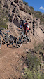
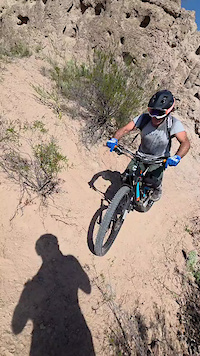
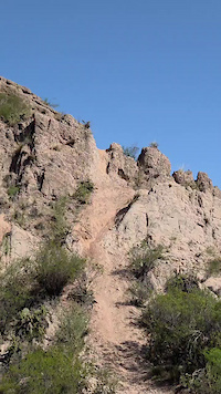
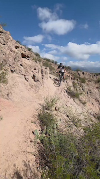
SaveThis country can be considered the end of the world. If you want to live a complete adventure. this is your place. Argentina don´t has machine build trails, or trail with design. most of the trails in Argentina are wild.
Stats
- Avg Trail Rating
- Trails (view details)
- 2,045
- Trails Mountain Bike
- 1,908
- Trails E-Bike
- 1,304
- Trails Adaptive Bike
- 2
- Trails Winter Fat Bike
- 2
- Trails Horse
- 454
- Trails Hike
- 1,879
- Trails Trail Running
- 1,868
- Trails Dirtbike/Moto
- 667
- Trails Observed Trials
- 88
- Trails ATV/ORV/OHV
- 45
- Trails Snowmobile
- 3
- Trails Snowshoe
- 6
- Trails Downhill Ski
- 3
- Trails Backcountry Ski
- 11
- Trails Nordic Ski
- 3
- Total Distance
- 3,107 miles
- Total Descent
- 497,028 ft
- Total Vertical
- 14,342 ft
- Highest Trailhead
- 14,345 ft
- Reports
- 5,099
- Photos
- 2,123
- Ridden Counter
- 54,100
Popular Trail Networks
view all areas »Sub Regions
- Buenos Aires (Province) (12)
- Buenos Aires (1)
- General Belgrano (1)
- General Rodriguez (3)
- Pilar Centro (6)
- Pinamar (1)
- Buenos Aires (1)
- Catamarca (Province) (4)
- Catamarca (4)
- Catamarca (4)
- Chubut (Province) (15)
- Comodoro Rivadavia (7)
- Esquel (1)
- Puerto Madryn (6)
- Comodoro Rivadavia (7)
- Ciudad de Buenos Aires (Distrito Federal) (36)
- Capital Federal (34)
- Capital Federal (34)
- Córdoba (Province) (40)
- Alta Gracia (7)
- Ascochinga (12)
- Cordoba (2)
- Malaga (2)
- Mina Clavero (1)
- San Roque (16)
- Alta Gracia (7)
- Entre Ríos (Province) (0)
- Formosa (Province) (0)
- Jujuy (Province) (5)
- La Pampa (Province) (1)
- Departemento Capital (1)
- Santa Rosa (1)
- Departemento Capital (1)
- La Rioja (Province) (18)
- Chilecito (18)
- Chilecito (18)
- Las Violetas Puente de Hierro (0)
- Mendoza (Province) (1,039)
- Departamento Las Heras (28)
- LAS HERAS (3)
- Departamento Malargue (1)
- Malargue (1)
- Precordillera (1)
- Lujan de Cuyo (248)
- Mendoza (663)
- Rivadavia (68)
- Tunuyan (2)
- Tupungato (2)
- Uspallata (1)
- Departamento Las Heras (28)
- Misiones (Province) (1)
- Neuquén (Province) (251)
- Departemento Los Lagos (31)
- Villa la Angostura (31)
- El Chocon (3)
- Moquehue (1)
- Neuquen (9)
- San Martin De Los Andes (207)
- Villa Pehuenia (3)
- Departemento Los Lagos (31)
- Río Negro (Province) (400)
- Departamento Ñorquincó (1)
- Ñorquincó (1)
- Departemento Bariloche (139)
- El Bolson (1)
- San Carlos de Bariloche (138)
- Departemento General Roca (259)
- Allen (5)
- Catriel (39)
- Cipolletti (6)
- General Roca (209)
- Departemento Veinticinco de Mayo (1)
- Departamento Ñorquincó (1)
- Salta (Province) (3)
- Salta (2)
- Salta (2)
- San Juan (Province) (5)
- San Juan (4)
- San Juan (4)
- San Luis (Province) (1)
- San Luis (1)
- San Luis (1)
- Santa Cruz (Province) (2)
- Rio Gallegos (1)
- Río Turbio (1)
- Rio Gallegos (1)
- Santa Fe (Province) (1)
- Santa Fe (1)
- Santa Fe (1)
- Santiago del Estero (Province) (1)
- Tierra del Fuego (Province) (52)
- Tucumán (Province) (10)
Popular Argentina Mountain Biking Trails
• 100 ★ 4.3 • 1,305 ft • 0 ft • 274 •
Popular green difficulty singletrack. This mountain bike primary trail can be used both directions. On average it takes 1 minutes to complete this trail.
• 95 ★ 4.8 • 5,220 ft • 215 ft • 262 •
Popular green difficulty singletrack. This multi-use trail can be used both directions and has a moderate overall physical rating with a 215 ft green climb. Trail visibility is always easy to follow. On average it takes 11 minutes to complete this trail.
• 100 ★ 4.8 • 1 mile • 11 ft • 262 •
Popular blue difficulty singletrack. This multi-use trail can be used downhill primary and has a moderate overall physical rating with a 11 ft blue climb. Trail visibility is always easy to follow. On average it takes 7 minutes to complete this trail.
• 95 ★ 4.0 • 2,288 ft • 2 ft • 256 •
Popular green difficulty singletrack. This mountain bike primary trail can be used both directions. On average it takes 2 minutes to complete this trail.
• 100 ★ 5.0 • 2,526 ft • 11 ft • 220 •
se ingresa por picada scoobys chicos o por la viborita
• 95 ★ 4.0 • 2,415 ft • 66 ft • 217 •
Popular green difficulty singletrack. This multi-use trail can be used both directions and has a easy overall physical rating with a 66 ft green climb. Trail visibility is always easy to follow. On average it takes 3 minutes to complete this trail.
• 100 ★ 5.0 • 535 ft • 15 ft • 216 •
Popular green difficulty singletrack. This multi-use trail can be used both directions with a 15 ft green climb. Trail visibility is always easy to follow. On average it takes minutes to complete this trail.
• 95 ★ 4.5 • 2,858 ft • 40 ft • 206 •
Popular green difficulty singletrack. This mountain bike primary trail. On average it takes 2 minutes to complete this trail.
Argentina Mountain Bike Routes
18 miles • 3,359 ft • 6 •
Recorrido para la final del Open Shimano Enduro.
★ 5.0 • 4 miles • 451 ft • 2 • Point to Point •
Nice single track, with a steep uphill at the beggining, a nice flat top with amazing views at the top,...
★ 4.0 • 1 mile • 347 ft • 7 •
El Camino del Tibetano siguiendo la filosofía de su autor es un sendero que con una pendiente constante...
★ 5.0 • 10 miles • 1,188 ft • 6 • Point to Point •
Circuito numero 1 de los previstos en la futura señalizacion de la zona.
★ 4.0 • 23 miles • 3,264 ft • 9 •
Excelente travesia mucho flowwww exigente requiere logistica de vehiculos
Photos of Argentina Mountain Bike
Videos of Argentina Mountain Bike
trail: Tobogán Mágico
0:29 |
5 |
Jun 8, 2026
trail: La Comunista
0:17 |
14 |
Apr 13, 2026
trail: La Comunista
0:23 |
10 |
Apr 13, 2026
trail: La Comunista
0:11 |
13 |
Apr 13, 2026
trail: La Comunista
0:13 |
9 |
Apr 13, 2026
trail: La Comunista
0:12 |
9 |
Mar 1, 2026
trail: La Comunista
0:26 |
13 |
Mar 1, 2026
trail: La Comunista
0:16 |
12 |
Mar 1, 2026
Recent Comments
| username | type | title | comment | date |
|---|---|---|---|---|
| trail | nice berms and a well made wooden ramp drop off. | May 31, 2026 @ 10:36am May 31, 2026 | ||
| trail | this is the route to ascend Cerro Bella Vista.... | May 31, 2026 @ 10:34am May 31, 2026 | ||
| trail | worth the extra climb | May 31, 2026 @ 9:31am May 31, 2026 | ||
| trail | The ascent is doable on an analogue bike but... | May 31, 2026 @ 9:29am May 31, 2026 | ||
| trail | Super fun. lots of corners. fast all the way down. | May 31, 2026 @ 9:25am May 31, 2026 |
Bike & Skill Parks
| name | type | city | rating |
|---|---|---|---|
| Chapelco Bike Park | bike park | San Martin de los Andes | |
| Xawün Weney Bikepark | bike park | San Martin de los Andes | |
| Skatepark Plaza Haiti | skill park | Capital Federal | |
| Trial Pool | skill park | Cordoba | |
| Mini DH | skill park | Córdoba Capital |
Activity Type Stats
| activitytype | trails | distance | descent | descent distance | total vertical | rating | global rank | state rank | photos | reports | routes | ridelogs |
|---|---|---|---|---|---|---|---|---|---|---|---|---|
| Mountain Bike | 1,908 | 2,867 miles | 463,494 ft | 1,272 miles | 14,341 ft | #22 | 2,051 | 5,082 | 98 | 114,123 | ||
| E-Bike | 1,304 | 1,806 miles | 269,701 ft | 795 miles | 11,302 ft | #22 | 7 | 4,664 | 36 | 3,404 | ||
| Adaptive Bike | 2 | #31 | 2 | 5 | ||||||||
| Winter Fat Bike | 2 | #32 | 2 | 1 | ||||||||
| Horse | 454 | 797 miles | 101,444 ft | 334 miles | 11,266 ft | #18 | 737 | 12 | ||||
| Hike | 1,834 | 2,503 miles | 406,345 ft | 1,069 miles | 14,341 ft | #22 | 32 | 4,865 | 7 | 7,159 | ||
| Trail Running | 1,868 | 2,487 miles | 397,533 ft | 1,062 miles | 14,341 ft | #22 | 1 | 4,854 | 13 | 5,771 | ||
| Dirtbike/Moto | 667 | 952 miles | 123,780 ft | 407 miles | 11,257 ft | #12 | 39 | 1,241 | 4 | 64 | ||
| Observed Trials | 88 | 232 miles | 24,072 ft | 97 miles | 8,294 ft | #22 | 2 | 61 | 17 | |||
| ATV/ORV/OHV | 45 | 183 miles | 15,554 ft | 75 miles | 10,128 ft | #26 | 529 | 2 | 14 | |||
| Snowmobile | 3 | 1 mile | 1,417 ft | 5,177 ft | 1,404 ft | #26 | 3 | |||||
| Snowshoe | 5 | 6 miles | 2,762 ft | 4 miles | 3,199 ft | #23 | 5 | 8 | ||||
| Downhill Ski | 3 | 1 mile | 1,417 ft | 5,177 ft | 1,404 ft | #25 | 3 | 411 | ||||
| Backcountry Ski | 11 | 22 miles | 6,594 ft | 10 miles | 3,199 ft | #25 | 2 | 369 | ||||
| Nordic Ski | 3 | 1 mile | 1,417 ft | 5,177 ft | 1,404 ft | #24 | 6 | 256 |
Activities
- Argentina Mountain Biking Trails
- Argentina E-Biking Trails
- Argentina Horseback Trails
- Argentina Hiking Trails
- Argentina Trail Running Trails
- Argentina Dirtbiking Trails
- Argentina Observed Trials Trails
- Argentina ATVing/Offroading Trails
- Argentina Snowshoeing Trails
- Argentina Backcountry Skiing Trails
Trails
Points of Interest
- Mirador Cascada Ana Viewpoint
- Camping Lago Queñi
- Aguas Arriba Lodge
- Mirador Laguna Torre Viewpoint
- Mirador Cascada Margarita Viewpoint
- Refugio Papá Manuel Cabin
- Mirador del Doctor Viewpoint
- Los Cesares Camping
- Volcán Lanín Summit
- Camping Parque Nacional Lanin
- Cerro Bonete Chico (22,080 ft)
- Cerro Veladero (21,040 ft)
- Antofalla Sur (21,020 ft)
- By canadaka
 Trailforks & contributors
 - Admins: MTBar, panchobuc
- #3225 - 29,955 views
- argentina activity log | embed map of Argentina mountain bike trails | argentina mountain biking points of interest polygons
Downloading of trail gps tracks in kml & gpx formats is enabled for Argentina.
You must login to download files.