close
-
Layers w
- Weather Layers
- Pro
- Pro
- Pro
- Pro
- Pro
- Pro
- More Layers
- Pro
- Pro
- Pro
- Pro
-
Upgrade to

3D
Trail Conditions
- Unknown
- Snow Groomed
- Snow Packed
- Snow Covered
- Snow Cover Partial
- Freeze/thaw Cycle
- Icy
- Prevalent Mud
- Wet
- Variable
- Ideal
- Dry
- Very Dry
Trail Flow (Ridden Direction)
Trailforks scans users ridelogs to determine the most popular direction each trail is ridden. A good flowing trail network will have most trails flowing in a single direction according to their intension.
The colour categories are based on what percentage of riders are riding a trail in its intended direction.
The colour categories are based on what percentage of riders are riding a trail in its intended direction.
- > 96%
- > 90%
- > 80%
- > 70%
- > 50%
- < 50%
- bi-directional trail
- no data
Trail Last Ridden
Trailforks scans ridelogs to determine the last time a trail was ridden.
- < 2 days
- < 1 week
- < 2 weeks
- < 1 month
- < 6 months
- > 6 months
Trail Ridden Direction
The intended direction a trail should be ridden.
- Downhill Only
- Downhill Primary
- Both Directions
- Uphill Primary
- Uphill Only
- One Direction
Contribute Details
Colors indicate trail is missing specified detail.
- Description
- Photos
- Description & Photos
- Videos
Trail Popularity ?
Trailforks scans ridelogs to determine which trails are ridden the most in the last 9 months.
Trails are compared with nearby trails in the same city region with a possible 25 colour shades.
Think of this as a heatmap, more rides = more kinetic energy = warmer colors.
- most popular
- popular
- less popular
- not popular
ATV/ORV/OHV Filter
Max Vehicle Width
inches
US Cell Coverage
Legend

Radar Time
Activity Recordings
Trailforks uses anonymized public activity data.
?
Activity Recordings
Trailforks uses anonymized public activity data.
?
Personal Heatmap
▶
Activity Types
all
/
none
▶
Options
2
Date range
month
–
Winter Trails
Warning
A routing network for winter maps does not exist. Selecting trails using the winter trails layer has been disabled.
Missing Trails
Most Popular
Least Popular
Trails are colored based on popularity. The more popular a trail is, the more red. Less popular trails trend towards green.
Jump Magnitude Heatmap
Heatmap of where riders jump on trails. Zoom in to see individual jumps, click circles to view jump details.
BC Backroad Status
![map legend]()
Service Road Atlas is a free to use, community-driven service for viewing and creating reports on the numerous back-country service roads around B.C. and Alberta.

Slope Aspect
Direction the slope faces
Trails Deemphasized
Trails are shown in grey.
Only show trails with no bike usage.
Suggested Layers
Based on selected activity type
Save the current map location and zoom level as your default home location whenever this page is loaded.
Save
No description for Argentona has been added yet!
Login or register to submit one.
 google parking directions
Primary Trail Type: All-Mountain & Downhill
eBikes Allowed:
Yes
google parking directionsThis region uses the Uk/Euro style trail grading system.
Activities Click to view
- Mountain Bike
110 trails
- E-Bike
110 trails
- Hike
84 trails
- Trail Running
82 trails
Region Details
- 34
- 24
- 37
- 5
- 5
Region Status
Caution as of 9 hoursStats
- Avg Trail Rating
- Trails (view details)
- 105
- Trails Mountain Bike
- 110
- Trails E-Bike
- 110
- Trails Adaptive Bike
- 8
- Trails Horse
- 1
- Trails Hike
- 84
- Trails Trail Running
- 82
- Total Distance
- 45 miles
- Total Descent
- 16,350 ft
- Total Vertical
- 1,327 ft
- Highest Trailhead
- 1,540 ft
- Reports
- 611
- Photos
- 33
- Ridden Counter
- 4,398
Popular Argentona Mountain Biking Trails
• 95 ★ 4.4 • 4,229 ft • 7 ft • 280 •
Dels millors corriols de flow de la zona, la part de dalt són tot curves amb força peraltes ràpids. La part de baix és més plana i ressegueix la part d'una petita riera amb alguns arbres que es poden passar bé. Hi ha un gran arbre...
• 85 ★ 4.6 • 3,714 ft • 10 ft • 238 •
Sendero sin mayor dificultad, curvas peraltadas, saltos que puedes no hacer si quieres, toboganes. Rápida y divertida.
• 80 ★ 3.0 • 692 ft • 108 ft • 229 •
Narrow singletrack. It's possible to ride in both directions.
• 85 ★ 5.0 • 1 mile • 148 ft • 223 •
Popular blue difficulty singletrack. This multi-use trail can be used downhill primary. It features berm. On average it takes 8 minutes to complete this trail.
• 65 ★ 4.9 • 1,654 ft • 0 ft • 142 •
Comença suau i als pocs metres hi ha una variant a la dreta que és la bona
• 75 ★ 3.0 • 1,339 ft • 0 ft • 142 •
Popular blue difficulty singletrack. This multi-use trail can be used downhill primary. It features berm. Trail visibility is always easy to follow. On average it takes 1 minutes to complete this trail.
Argentona Mountain Bike Routes
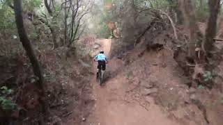
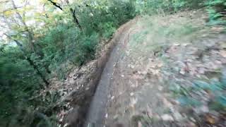
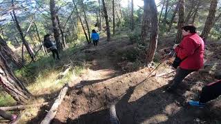
Photos of Argentona Mountain Bike
Videos of Argentona Mountain Bike
0:49 |
|
May 28, 2024
trail: La Poma Podrida
5:32 |
370 |
Mar 19, 2023
trail: El Tubillo
5:42 |
355 |
Jan 26, 2024 , Mataró
trail: Infernal
4:50 |
391 |
Jan 22, 2024 , Mataró
trail: Calimero
3:26 |
889 |
Oct 7, 2023 , Mataró
trail: Calimero
2:09 |
282 |
Feb 14, 2023 , Mataró

trail: Antenes de Montcabrer
2:26 |
314 |
Jul 26, 2022 , Mataró
trail: Font de la Cua Llarga
2:32 |
458 |
Jan 21, 2021 , Mataró
Current Trail Warnings
| status | trail | date | condition | user | info |
|---|---|---|---|---|---|
| Tocahombros / La Bèstia | Jun 17, 2026 @ 8:13pm (Europe/Andorra) 9 hours | Dry | pimterry | La parte arriba (hasta font del llop al... |
Recent Trail Reports
| status | trail | date | condition | info | user |
|---|---|---|---|---|---|
| Font Picant | Jun 17, 2026 @ 8:13pm (Europe/Andorra) 9 hours | Dry | pimterry | ||
| Els Bolets | Jun 17, 2026 @ 8:13pm (Europe/Andorra) 9 hours | Dry | pimterry | ||
| Font del Llop | Jun 17, 2026 @ 8:13pm (Europe/Andorra) 9 hours | Dry | pimterry | ||
| Pista | Jun 17, 2026 @ 8:13pm (Europe/Andorra) 9 hours | Dry | pimterry | ||
| Carretera del Rocar d'en Serra | Jun 17, 2026 @ 8:13pm (Europe/Andorra) 9 hours | Dry | pimterry | ||
| Calimero | Jun 10, 2026 @ 6:12pm (Europe/Andorra) Jun 10, 2026 | Dry | CarlesRocabikes | ||
| Riudemeia | May 29, 2026 @ 1:49pm (Europe/Madrid) May 29, 2026 | Dry | Pecon | ||
| La Riera-Can Carmany | May 1, 2026 @ 7:55am (Europe/Andorra) Apr 30, 2026 | Dry | gimber | ||
| Infernal | Apr 26, 2026 @ 7:58am (Europe/Andorra) Apr 25, 2026 | Dry | pinsanjo | ||
| Corriol de la Mutua 2 | Apr 26, 2026 @ 7:58am (Europe/Andorra) Apr 25, 2026 | Dry | pinsanjo |
Activity Feed
| username | action | type | title | date |
|---|---|---|---|---|
| pimterry | vote | trail | activity #97208691 | Jun 17, 2026 @ 2:09pm 6 hours |
| pimterry | add | report | activity #97208684 and 5 more | Jun 17, 2026 @ 2:09pm 6 hours |
| CarlesRocabikes | add | report | activity #97091885 | Jun 16, 2026 @ 12:34am 2 days |
| AlbertoFoncu | wishlist | region | activity #97067498 | Jun 15, 2026 @ 3:00pm 2 days |
| dump | vote | trail | activity #96151439 and 4 more | Jun 3, 2026 @ 6:41am Jun 3, 2026 |
Recent Comments
| username | type | title | comment | date |
|---|---|---|---|---|
| trail | Todo bien sin incidencias. Limpio. | Apr 19, 2026 @ 9:46am Apr 19, 2026 | ||
| trail | No está en muy buenas condiciones. A los 30... | Apr 19, 2026 @ 9:45am Apr 19, 2026 | ||
| trail | Se cambia a rojo | Apr 12, 2026 @ 10:21pm Apr 12, 2026 | ||
| trail | A quien queréis matar ? No es azul ni de... | Apr 12, 2026 @ 5:13am Apr 12, 2026 | ||
| trail | Limpia en buen estado | Mar 27, 2026 @ 1:50pm Mar 27, 2026 |
Nearby Areas
| name | distance | ||||
|---|---|---|---|---|---|
| Vilassar-Premià de Dalt | 5 | 8 | 2.6 km | ||
| La Roca | 12 | 36 | 3.7 km | ||
| Vallromanes | 5 | 18 | 4.4 km | ||
| Serralada Marina - Litoral | 19 | 27 | 6.8 km | ||
| Sant Vicenç de Montalt | 15 | 43 | 6.9 km |
Local Badges
-

Completionist0 awarded
Activity Type Stats
| activitytype | trails | distance | descent | descent distance | total vertical | rating | global rank | state rank | photos | reports | routes | ridelogs |
|---|---|---|---|---|---|---|---|---|---|---|---|---|
| Mountain Bike | 110 | 45 miles | 16,352 ft | 25 miles | 1,329 ft | #2,370 | #196 | 29 | 611 | 2 | 2,063 | |
| E-Bike | 110 | 45 miles | 16,352 ft | 25 miles | 1,329 ft | #965 | #290 | 4 | 600 | 1 | 1,335 | |
| Adaptive Bike | 7 | |||||||||||
| Horse | 1 | 2,959 ft | 62 ft | 912 ft | 138 ft | 22 | ||||||
| Hike | 84 | 34 miles | 11,037 ft | 18 miles | 1,253 ft | #4,461 | #512 | 533 | 2 | 110 | ||
| Trail Running | 82 | 34 miles | 11,037 ft | 18 miles | 1,253 ft | #3,458 | #481 | 532 | 229 |
Frequently Asked Questions About Argentona
▼
What are the highest rated mountain biking trails in Argentona?
The highest rated mountain biking trails in Argentona are:
- Peraltes d'Òrrius (4.4/5)
- Tocahombros / La Bèstia (4.4/5)
- La Gerson (4.4/5)
- Les Planes (4.4/5)
- Calimero (4.2/5)
▼
Where can I park to ride in Argentona?
There are 1 parking locations listed in Argentona. The most popular parking spots are:
▼
What is the longest trail in Argentona?
The longest trail in Argentona is L'Extrem at 2.0 miles. View all trails sorted by distance.
▼
What are the best & highest rated hiking trails in Argentona?
The best hiking trails in Argentona are: View all hiking trails sorted by popularity score.
Activities
- argentona activity log | embed map of Argentona mountain bike trails | argentona mountain biking points of interest
Downloading of trail gps tracks in kml & gpx formats is enabled for Argentona.
You must login to download files.