close
-
Layers w
- Weather Layers
- Pro
- Pro
- Pro
- Pro
- Pro
- Pro
- More Layers
- Pro
- Pro
- Pro
- Pro
-
Upgrade to

3D
Trail Conditions
- Unknown
- Snow Groomed
- Snow Packed
- Snow Covered
- Snow Cover Partial
- Freeze/thaw Cycle
- Icy
- Prevalent Mud
- Wet
- Variable
- Ideal
- Dry
- Very Dry
Trail Flow (Ridden Direction)
Trailforks scans users ridelogs to determine the most popular direction each trail is ridden. A good flowing trail network will have most trails flowing in a single direction according to their intension.
The colour categories are based on what percentage of riders are riding a trail in its intended direction.
The colour categories are based on what percentage of riders are riding a trail in its intended direction.
- > 96%
- > 90%
- > 80%
- > 70%
- > 50%
- < 50%
- bi-directional trail
- no data
Trail Last Ridden
Trailforks scans ridelogs to determine the last time a trail was ridden.
- < 2 days
- < 1 week
- < 2 weeks
- < 1 month
- < 6 months
- > 6 months
Trail Ridden Direction
The intended direction a trail should be ridden.
- Downhill Only
- Downhill Primary
- Both Directions
- Uphill Primary
- Uphill Only
- One Direction
Contribute Details
Colors indicate trail is missing specified detail.
- Description
- Photos
- Description & Photos
- Videos
Trail Popularity ?
Trailforks scans ridelogs to determine which trails are ridden the most in the last 9 months.
Trails are compared with nearby trails in the same city region with a possible 25 colour shades.
Think of this as a heatmap, more rides = more kinetic energy = warmer colors.
- most popular
- popular
- less popular
- not popular
ATV/ORV/OHV Filter
Max Vehicle Width
inches
US Cell Coverage
Legend

Radar Time
Activity Recordings
Trailforks uses anonymized public activity data.
?
Activity Recordings
Trailforks uses anonymized public activity data.
?
Personal Heatmap
▶
Activity Types
all
/
none
▶
Options
2
Date range
month
–
Winter Trails
Warning
A routing network for winter maps does not exist. Selecting trails using the winter trails layer has been disabled.
Missing Trails
Most Popular
Least Popular
Trails are colored based on popularity. The more popular a trail is, the more red. Less popular trails trend towards green.
Jump Magnitude Heatmap
Heatmap of where riders jump on trails. Zoom in to see individual jumps, click circles to view jump details.
BC Backroad Status
![map legend]()
Service Road Atlas is a free to use, community-driven service for viewing and creating reports on the numerous back-country service roads around B.C. and Alberta.

Slope Aspect
Direction the slope faces
Trails Deemphasized
Trails are shown in grey.
Only show trails with no bike usage.
Suggested Layers
Based on selected activity type
Save the current map location and zoom level as your default home location whenever this page is loaded.
Save
No description for Arrowhead Enduro Trails has been added yet!
Login or register to submit one.
 google parking directions
Primary Trail Type: All-Mountain & Downhill
Land Status: City Managed
Land Manager: City of Claremont
google parking directions Region Supporters & Maintainers
![]()
The Wheel House
since 2023Sponsor![]()
Claremont Parks & Recreation
Activities Click to view
- Mountain Bike
18 trails
- E-Bike
18 trails
- Hike
10 trails
- Trail Running
9 trails
Region Details
- 2
- 6
- 6
- 3
Region Status
Open as of May 30, 2026Stats
- Avg Trail Rating
- Global Ranking
- #4,413
- Trails (view details)
- 20
- Trails Mountain Bike
- 18
- Trails E-Bike
- 18
- Trails Hike
- 10
- Trails Trail Running
- 9
- Total Distance
- 7 miles
- Total Descent Distance
- 4 miles
- Total Descent
- 3,727 ft
- Total Vertical
- 538 ft
- Highest Trailhead
- 1,090 ft
- Reports
- 299
- Photos
- 16
- Ridden Counter
- 5,862
Articles
Video & Race Report: Eastern States Cup Enduro #3 - Arrowhead, NH
Jun 2, 2026 from pinkbike.com
Dakota Alix puts down the watts to snap Jax Schmitz's year-long dominance as racers battle wet roots and loam shelves at Arrowhead, New Hampshire.

Video & Race Report: Maxxis Eastern States Cup Stan's Enduro Finals - Arrowhead, NH
Oct 14, 2025 from pinkbike.com
Autumn has come to New England, and we're down to one last battle for all the marbles.
Video & Race Report: Maxxis Eastern States Cup Stan's Enduro #2 - Arrowhead, NH
Jun 4, 2025 from pinkbike.com
Mother Nature had her own plan this weekend, soaking the soil on Saturday which made the steep sections more of a slip and slide than usual.
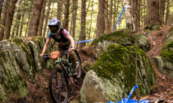
Popular Arrowhead Enduro Trails Mountain Biking Trails
• 100 ★ 5.0 • 663 ft • 15 ft • 608 •
Popular green difficulty singletrack. This multi-use trail can be used one direction. On average it takes 1 minutes to complete this trail.
• 95 ★ 4.0 • 2,785 ft • 0 ft • 569 •
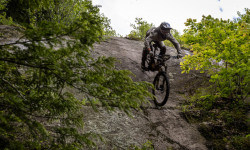
Popular black diamond difficulty singletrack. This mountain bike primary trail. On average it takes 8 minutes to complete this trail.
• 85 ★ 4.0 • 2,953 ft • 0 ft • 500 •
Popular blue difficulty singletrack. This mountain bike primary trail and has a hard overall physical rating. On average it takes 6 minutes to complete this trail.
• 80 ★ 4.3 • 2,480 ft • 7 ft • 500 •
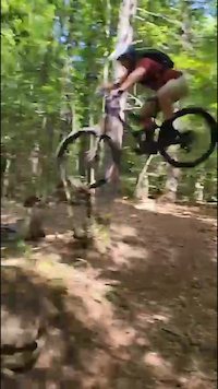
Popular black diamond difficulty singletrack. This mountain bike primary trail can be used one direction and has a hard overall physical rating with a 7 ft black diamond climb. It features berm, drop, jump, gap jump, rock face and rock garden. Trail visibility is always easy to follow. On average it takes 9 minutes to complete this trail.
• 85 ★ 4.2 • 2,080 ft • 0 ft • 470 •
Popular double black diamond difficulty singletrack. This mountain bike primary trail can be used one direction. It features berm, drop, jump, gap jump, rock face and rock garden. On average it takes 13 minutes to complete this trail.
• 80 ★ 5.0 • 2,474 ft • 0 ft • 350 •
Popular black diamond difficulty singletrack. This mountain bike primary trail can be used one direction. On average it takes 7 minutes to complete this trail.
• 65 ★ 4.4 • 3,002 ft • 7 ft • 350 •
Moderately popular double black diamond difficulty singletrack. This mountain bike primary trail can be used one direction and has a hard overall physical rating. It features berm, drop, jump, rock face and rock garden. Trail visibility is always easy to follow. On average it takes 9 minutes to complete this trail.
• 70 ★ 4.4 • 2,779 ft • 0 ft • 335 •
Popular black diamond difficulty singletrack. This mountain bike primary trail can be used downhill only and has a moderate overall physical rating. It features berm, drop, jump and rock face. Trail visibility is always easy to follow. On average it takes 8 minutes to complete this trail.
Photos of Arrowhead Enduro Trails Mountain Bike


Recent Trail Reports
| status | trail | date | condition | info | user |
|---|---|---|---|---|---|
| Hot Pocket | May 30, 2026 @ 1:06pm (America/New_York) May 30, 2026 | Variable | nikodemus | ||
| Climbing Trail ( Uppity) Shared access | May 30, 2026 @ 1:06pm (America/New_York) May 30, 2026 | Variable | nikodemus | ||
| Arrowhead Parking Area | May 30, 2026 @ 1:06pm (America/New_York) May 30, 2026 | Variable | nikodemus | ||
| Waka Waka | May 30, 2026 @ 1:06pm (America/New_York) May 30, 2026 | Variable | nikodemus | ||
| Dirty Frank | May 30, 2026 @ 1:06pm (America/New_York) May 30, 2026 | Variable | nikodemus | ||
| WTG13 | May 30, 2026 @ 1:06pm (America/New_York) May 30, 2026 | Variable | nikodemus | ||
| Fixer | May 30, 2026 @ 1:06pm (America/New_York) May 30, 2026 | Variable | nikodemus | ||
| Special K | May 30, 2026 @ 1:06pm (America/New_York) May 30, 2026 | Variable | nikodemus | ||
| C-2 | May 30, 2026 @ 1:06pm (America/New_York) May 30, 2026 | Variable | nikodemus | ||
| Tomahawk | May 29, 2026 @ 1:33pm (America/New_York) May 29, 2026 | Variable | nikodemus |
Activity Feed
| username | action | type | title | date |
|---|---|---|---|---|
| mcosgrave | wishlist | region | activity #97070842 | Jun 15, 2026 @ 3:58pm 3 days |
| ilv2srf | wishlist | region | activity #96660563 | Jun 10, 2026 @ 2:53am Jun 10, 2026 |
| Bobbymustard | wishlist | trail | activity #96318772 | Jun 5, 2026 @ 1:41pm Jun 5, 2026 |
| livewithspeed | add | photo | activity #96298304 and 1 more | Jun 5, 2026 @ 8:30am Jun 5, 2026 |
| derekboyle-mtb | wishlist | region | activity #96293607 | Jun 5, 2026 @ 7:17am Jun 5, 2026 |
Recent Comments
| username | type | title | comment | date |
|---|---|---|---|---|
| trail | Definitely the most intense here. Many steep... | Aug 28, 2025 @ 6:59pm Aug 28, 2025 | ||
| trail | A step up from the single blacks, but only two... | Aug 28, 2025 @ 6:58pm Aug 28, 2025 | ||
| trail | Quite rocky and techy, fun to find a good... | Aug 28, 2025 @ 6:57pm Aug 28, 2025 | ||
| trail | Mellow to the road gap, then a couple off... | Aug 28, 2025 @ 6:56pm Aug 28, 2025 | ||
| trail | Fairly wide open with lots of undulations and... | Aug 28, 2025 @ 6:55pm Aug 28, 2025 |
Nearby Areas
| name | distance | ||||
|---|---|---|---|---|---|
| Moody Park | 8 | 6 | 2 | 1.7 km | |
| Cornish Town forest | 11 | 6 | 5.2 km | ||
| Swoops n Loops | 6.6 km | ||||
| Newport Town Forest - The Pinnacle | 3 | 16 | 3 | 1 | 8.4 km |
| Ascutney Trails | 43 | 31 | 24 | 1 | 9.2 km |
Activity Type Stats
| activitytype | trails | distance | descent | descent distance | total vertical | rating | global rank | state rank | photos | reports | routes | ridelogs |
|---|---|---|---|---|---|---|---|---|---|---|---|---|
| Mountain Bike | 18 | 6 miles | 3,724 ft | 4 miles | 518 ft | #4,413 | 16 | 298 | 2,317 | |||
| E-Bike | 18 | 6 miles | 3,724 ft | 4 miles | 518 ft | #6,174 | #1,750 | 253 | 184 | |||
| Hike | 10 | 2 miles | 531 ft | 3,570 ft | 538 ft | #15,002 | #6,678 | 266 | 227 | |||
| Trail Running | 9 | 2 miles | 531 ft | 3,570 ft | 538 ft | #15,667 | #6,901 | 265 | 13 |
Frequently Asked Questions About Arrowhead Enduro Trails
▼
What are the highest rated mountain biking trails in Arrowhead Enduro Trails?
▼
What is the best time of the year to ride in Arrowhead Enduro Trails?
Based on ride log data, the most popular months to ride in Arrowhead Enduro Trails are:
- August (17 activities)
- October (16 activities)
- May (13 activities)
▼
Where can I park to ride in Arrowhead Enduro Trails?
There are 3 parking locations listed in Arrowhead Enduro Trails. The most popular parking spots are: View all parking and trailhead locations on the map to plan your visit.
▼
What is the longest trail in Arrowhead Enduro Trails?
The longest trail in Arrowhead Enduro Trails is Fistfull of Cake at 1.1 miles. View all trails sorted by distance.
Activities
Trails
- Hard trails in Arrowhead Enduro Trails
- Easy trails in Arrowhead Enduro Trails
- Favorite trails in Arrowhead Enduro Trails
- Most ridden trails in Arrowhead Enduro Trails
- Singletrack in Arrowhead Enduro Trails
- Viewpoint trails in Arrowhead Enduro Trails
- Trails with technical features in Arrowhead Enduro Trails
Points of Interest
- By dropmnster & contributors
- Admins: AET, UWV
- #45846 - 17,890 views
- arrowhead enduro trails activity log | embed map of Arrowhead Enduro Trails mountain bike trails | arrowhead enduro trails mountain biking points of interest
Downloading of trail gps tracks in kml & gpx formats is enabled for Arrowhead Enduro Trails.
You must login to download files.