close
-
Layers w
- Weather Layers
- Pro
- Pro
- Pro
- Pro
- Pro
- Pro
- More Layers
- Pro
- Pro
- Pro
- Pro
-
Upgrade to

3D
Trail Conditions
- Unknown
- Snow Groomed
- Snow Packed
- Snow Covered
- Snow Cover Partial
- Freeze/thaw Cycle
- Icy
- Prevalent Mud
- Wet
- Variable
- Ideal
- Dry
- Very Dry
Trail Flow (Ridden Direction)
Trailforks scans users ridelogs to determine the most popular direction each trail is ridden. A good flowing trail network will have most trails flowing in a single direction according to their intension.
The colour categories are based on what percentage of riders are riding a trail in its intended direction.
The colour categories are based on what percentage of riders are riding a trail in its intended direction.
- > 96%
- > 90%
- > 80%
- > 70%
- > 50%
- < 50%
- bi-directional trail
- no data
Trail Last Ridden
Trailforks scans ridelogs to determine the last time a trail was ridden.
- < 2 days
- < 1 week
- < 2 weeks
- < 1 month
- < 6 months
- > 6 months
Trail Ridden Direction
The intended direction a trail should be ridden.
- Downhill Only
- Downhill Primary
- Both Directions
- Uphill Primary
- Uphill Only
- One Direction
Contribute Details
Colors indicate trail is missing specified detail.
- Description
- Photos
- Description & Photos
- Videos
Trail Popularity ?
Trailforks scans ridelogs to determine which trails are ridden the most in the last 9 months.
Trails are compared with nearby trails in the same city region with a possible 25 colour shades.
Think of this as a heatmap, more rides = more kinetic energy = warmer colors.
- most popular
- popular
- less popular
- not popular
ATV/ORV/OHV Filter
Max Vehicle Width
inches
US Cell Coverage
Legend

Radar Time
Activity Recordings
Trailforks uses anonymized public activity data.
?
Activity Recordings
Trailforks uses anonymized public activity data.
?
Personal Heatmap
▶
Activity Types
all
/
none
▶
Options
2
Date range
month
–
Winter Trails
Warning
A routing network for winter maps does not exist. Selecting trails using the winter trails layer has been disabled.
Missing Trails
Most Popular
Least Popular
Trails are colored based on popularity. The more popular a trail is, the more red. Less popular trails trend towards green.
Jump Magnitude Heatmap
Heatmap of where riders jump on trails. Zoom in to see individual jumps, click circles to view jump details.
BC Backroad Status
![map legend]()
Service Road Atlas is a free to use, community-driven service for viewing and creating reports on the numerous back-country service roads around B.C. and Alberta.

Slope Aspect
Direction the slope faces
Trails Deemphasized
Trails are shown in grey.
Only show trails with no bike usage.
Suggested Layers
Based on selected activity type
Save the current map location and zoom level as your default home location whenever this page is loaded.
Save
No description for Aspen has been added yet!
Login or register to submit one.

IMBA Ride Center
Roaring Fork/Aspen Snowmass
Activities Click to view
- Mountain Bike
120 trails
- E-Bike
25 trails
- Gravel Bike
30 trails
- Adaptive Bike
26 trails
- Winter Fat Bike
1 trails
- Horse
24 trails
- Hike
127 trails
- Trail Running
125 trails
- Dirtbike/Moto
2 trails
- ATV/ORV/OHV
1 trails
- Snowmobile
0 trails
- Snowshoe
65 trails
- Downhill Ski
474 trails
- Backcountry Ski
107 trails
- Nordic Ski
65 trails
Region Details
- 36
- 4
- 23
- 30
- 21
- 3
Region Status
Open as of Jun 21, 2026Stats
- Avg Trail Rating
- Trails (view details)
- 669
- Trails Mountain Bike
- 120
- Trails E-Bike
- 25
- Trails Gravel Bike
- 30
- Trails Adaptive Bike
- 26
- Trails Winter Fat Bike
- 1
- Trails Horse
- 24
- Trails Hike
- 127
- Trails Trail Running
- 125
- Trails Dirtbike/Moto
- 2
- Trails ATV/ORV/OHV
- 1
- Trails Snowshoe
- 65
- Trails Downhill Ski
- 474
- Trails Backcountry Ski
- 107
- Trails Nordic Ski
- 65
- Total Distance
- 488 miles
- Total Descent
- 283,504 ft
- Total Vertical
- 7,077 ft
- Highest Trailhead
- 12,798 ft
- Reports
- 523
- Photos
- 217
- Ridden Counter
- 49,139
Articles

A Complete Guide to Aspen on a Budget
Jan 7, 2022 from skimag.com
Plan strategically, and this Rocky Mountain resort can be experienced on the cheap.

Race Report: 2019 BME Finals in Aspen Snowmass
Aug 19, 2019 from pinkbike.com
The 2019 Yeti Cycles Big Mountain Enduro presented by Maxxis season came to an end last weekend in Aspen Snowmass, CO for the Grand Finale.
Sub Regions
-
Aspen Snowmass
- 1
-
Sky Mountain Park
- 2
- 6
- 1
-
Smuggler Mountain/Hunter Creek
- 2
- 5
- 13
- 11
- 2
Popular Aspen Mountain Biking Trails
• 95 ★ 4.2 • 4 miles • 100 ft • 719 •
The Trail can be ridden up or down, although downhill is preferred, but many riders will encounter it first as an extension to a traditional south to north Rim Trail Loop ride. Find the intersection a few minutes downhill from the North...
• 100 ★ 4.6 • 2 miles • 165 ft • 548 •
Now a downhill mountain bike only trail featuring large, generous sloped berms, dips, rollers and optional side hits. Everything can be rolled, but keep an eye ahead for larger optional jumps. Originally built in 2013, was a two way...
• 95 ★ 3.8 • 4,449 ft • 335 ft • 525 •
This trail connects the Smuggler Observation Deck to the Trail and Trail further up the mountain. Singletrack, fun both up and down. Look out for picnic tables, viewpoints, and evidence of historic mining activity.
• 90 ★ 4.7 • 2 miles • 710 ft • 507 •
This singletrack allows access to Sky Mountain Park and the excellent trail from the western Snowmass Village side. Access the trail via either end of the trail or from the east. From the Aspen side, via trail, this is a fun descent...
• 95 ★ 0.0 • 1 mile • 317 ft • 496 •
Highline is a short and fun trail that you can access at several locations, including Rd. and Owl Creek Rd. The trail includes beginner and intermediate sections, with a couple steep portions depending on which direction you're riding...
• 95 ★ 4.2 • 3 miles • 1,143 ft • 429 •
This is a new trail constructed in Summer and Fall of 2013. It provides access to Sky Mountain Park from the Intercept Lot area and Bike Path. The trail connects with at its upper end, and intersects with the new about 2/3 of the way...
• 90 ★ 5.0 • 4,560 ft • 9 ft • 407 •
Popular green difficulty singletrack. This mountain bike primary trail can be used both directions. On average it takes 4 minutes to complete this trail.
• 85 ★ 4.0 • 3,399 ft • 13 ft • 403 •
Popular blue difficulty singletrack. This mountain bike primary trail can be used both directions. Trail visibility is always easy to follow. On average it takes 3 minutes to complete this trail.
Aspen Mountain Bike Routes
★ 5.0 • 18 miles • 2,196 ft • 8 • Loop •
Ride the Skyline Ridge Adventure to experience an excellent selection of Snowmass trails. Expect a decent...
13 miles • 2,000 ft • 3 • Loop •
58 miles • 8,920 ft • 19 • Loop •
★ 1.0 • 13 miles • 2,369 ft • 7 • Loop •
Smuggler Mountain - Hunter Creek Loop Thirteen Miles
3 miles • 837 ft • 2 • Out & Back •
12 miles • 983 ft • 0 • Out & Back •
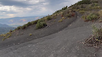
Photos of Aspen Mountain Bike
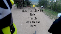
Videos of Aspen Mountain Bike
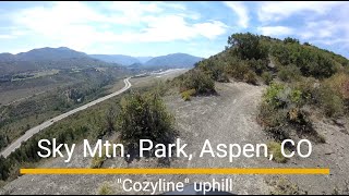
trail: Cozyline
14:50 |
29 |
Aug 23, 2023

trail: Sunnyside Trail
0:55 |
|
Mar 10, 2023
3:50 |
30 |
Jan 28, 2020
trail: High School
4:36 |
296 |
Nov 14, 2014
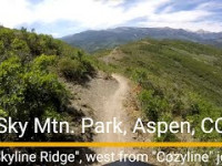
trail: Skyline Ridge
9:25 |
63 |
Aug 17, 2025 , Aspen
trail: Cozyline
16:38 |
81 |
Aug 16, 2025 , Aspen
trail: Viewline
5:07 |
71 |
Aug 11, 2025 , Aspen

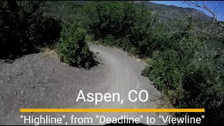
trail: Highline
5:07 |
50 |
Aug 11, 2025 , Aspen
Current Trail Warnings
| status | trail | date | condition | user | info |
|---|---|---|---|---|---|
| Deadline | Jun 21, 2026 @ 11:18pm (America/Denver) Jun 21, 2026 | Dry | Skyryk | Closed for massive trail maintenance. As... |
Recent Trail Reports
| status | trail | date | condition | info | user |
|---|---|---|---|---|---|
| Lowline | Jun 5, 2026 @ 11:27am (America/Denver) Jun 5, 2026 | Dry | dashraces | ||
| Highline | Jun 2, 2026 @ 3:07pm (America/Denver) Jun 2, 2026 | Unknown | colingfield | ||
| Rio Grande Soft Surface | Jun 1, 2026 @ 9:44am (America/Denver) Jun 1, 2026 | Ideal | extrapulp | ||
| Rio Grande Soft Surface | Jun 1, 2026 @ 9:44am (America/Denver) Jun 1, 2026 | Ideal | extrapulp | ||
| Rio Grand Soft Surface | Jun 1, 2026 @ 9:44am (America/Denver) Jun 1, 2026 | Ideal | extrapulp | ||
| Valkyrie Connector | Sep 28, 2025 @ 10:12am (America/Denver) Sep 28, 2025 | Ideal | Skyryk | ||
| Path | Sep 27, 2025 @ 2:19pm (America/Denver) Sep 27, 2025 | Ideal | Skyryk | ||
| Maroon Creek Multi-Use | Sep 27, 2025 @ 2:19pm (America/Denver) Sep 27, 2025 | Ideal | Skyryk | ||
| Behind The Sign (BTS) | Sep 25, 2025 @ 3:12pm (America/Denver) Sep 25, 2025 | Ideal | wilzy | ||
| Smuggler Mtn Road | Sep 25, 2025 @ 3:12pm (America/Denver) Sep 25, 2025 | Ideal | wilzy |
Activity Feed
| username | action | type | title | date |
|---|---|---|---|---|
| Skyryk | add | report | activity #97543355 | Jun 21, 2026 @ 10:19pm Jun 21, 2026 |
| WendyjpJwis | wishlist | route | activity #97539200 | Jun 21, 2026 @ 7:44pm Jun 21, 2026 |
| MDP21 | add | trail | activity #97244906 and 3 more | Jun 18, 2026 @ 5:24am Jun 18, 2026 |
| wreckman | wishlist | trail | activity #97199467 | Jun 17, 2026 @ 11:39am Jun 17, 2026 |
| jbranc | wishlist | trail | activity #97139597 | Jun 16, 2026 @ 2:57pm Jun 16, 2026 |
Recent Comments
| username | type | title | comment | date |
|---|---|---|---|---|
| trail | As a newcomer to the area, I really enjoyed... | Sep 7, 2025 @ 12:33pm Sep 7, 2025 | ||
| trail | Very reasonable uphill to some great trails. | Sep 7, 2025 @ 12:30pm Sep 7, 2025 | ||
| trail | Fun contour downhill with a few switchbacks.... | Sep 7, 2025 @ 12:28pm Sep 7, 2025 | ||
| trail | Riding great this summer. Lots of trail work... | Aug 18, 2025 @ 8:36pm Aug 18, 2025 | ||
| trail | The map of this trail should be redone. As it... | Aug 15, 2025 @ 12:11pm Aug 15, 2025 |
Local Badges
-

10 Green Trails54 awarded -

10 Blue Trails252 awarded -

10 Black Trails128 awarded -

Epic Ride Climb 2k345 awarded -

Climbing 10k Badge118 awarded -

Climbing 100k Badge12 awarded
Bike & Skill Parks
| name | type | city | rating |
|---|---|---|---|
| Aspen Snowmass | bike park | Aspen | |
| Aspen Mountain | bike park | Aspen | |
| Aspen Highlands | bike park | Aspen | |
| Buttermilk Mountain Aspen Snowmass | bike park | Aspen |
Activity Type Stats
| activitytype | trails | distance | descent | descent distance | total vertical | rating | global rank | state rank | photos | reports | routes | ridelogs |
|---|---|---|---|---|---|---|---|---|---|---|---|---|
| Mountain Bike | 120 | 194 miles | 30,010 ft | 69 miles | 6,585 ft | #741 | #288 | 216 | 484 | 10 | 11,456 | |
| E-Bike | 25 | 85 miles | 3,648 ft | 14 miles | 6,585 ft | #1,637 | #883 | 361 | 1 | 594 | ||
| Gravel Bike | 30 | 100 miles | 5,381 ft | 21 miles | 6,585 ft | #97 | #808 | 49 | 1 | 43 | ||
| Adaptive Bike | 26 | 77 miles | 3,707 ft | 14 miles | 5,833 ft | #109 | #1,455 | 45 | ||||
| Winter Fat Bike | 1 | 4,449 ft | 82 ft | 804 ft | 289 ft | #248 | #1,027 | 63 | ||||
| Horse | 24 | 73 miles | 11,683 ft | 27 miles | 5,413 ft | #665 | #535 | 108 | 1 | |||
| Hike | 127 | 242 miles | 35,253 ft | 79 miles | 7,077 ft | #332 | #158 | 1 | 454 | 4 | 2,580 | |
| Trail Running | 125 | 239 miles | 35,217 ft | 79 miles | 7,077 ft | #516 | #198 | 454 | 5 | 1,060 | ||
| Dirtbike/Moto | 2 | 9 miles | 581 ft | 2 miles | 3,343 ft | #759 | #268 | 99 | 4 | |||
| ATV/ORV/OHV | 1 | 9 miles | 436 ft | 1 mile | 2,513 ft | #586 | #225 | 93 | 1 | |||
| Snowshoe | 65 | 33 miles | 3,730 ft | 14 miles | 2,051 ft | #365 | #104 | 53 | 2 | 30 | ||
| Downhill Ski | 474 | 201 miles | 242,372 ft | 192 miles | 4,610 ft | #7 | #5 | 47 | 9,710 | |||
| Backcountry Ski | 107 | 37 miles | 57,871 ft | 34 miles | 3,488 ft | #70 | #14 | 47 | 2 | 4,337 | ||
| Nordic Ski | 65 | 33 miles | 3,730 ft | 14 miles | 2,051 ft | #233 | #65 | 48 | 1,219 |
Frequently Asked Questions About Aspen
▼
What are the best places to ride in Aspen?
Aspen has 6 areas to explore for mountain biking. The top rated areas are:
▼
What are the highest rated mountain biking trails in Aspen?
The highest rated mountain biking trails in Aspen are:
- Ajax Connector (4.4/5)
- Hannon Creek (4.4/5)
- Airline (4.4/5)
- Scotties (4.3/5)
- Sunnyside Trail (4.3/5)
▼
What is the best time of the year to ride in Aspen?
Based on ride log data, the most popular months to ride in Aspen are:
- August (45 activities)
- July (44 activities)
- September (43 activities)
▼
Where can I park to ride in Aspen?
There are 20 parking locations listed in Aspen. The most popular parking spots are: View all parking and trailhead locations on the map to plan your visit.
Activities
Trails
- By brenthillier
 NSMBA TRAILFORKS & contributors
 - Admins: apply
- #4154 - 20,983 views
- aspen activity log | embed map of Aspen mountain bike trails | aspen mountain biking points of interest
Downloading of trail gps tracks in kml & gpx formats is enabled for Aspen.
You must login to download files.