close
-
Layers w
- Weather Layers
- Pro
- Pro
- Pro
- Pro
- Pro
- Pro
- More Layers
- Pro
- Pro
- Pro
- Pro
-
Upgrade to

3D
Trail Conditions
- Unknown
- Snow Groomed
- Snow Packed
- Snow Covered
- Snow Cover Partial
- Freeze/thaw Cycle
- Icy
- Prevalent Mud
- Wet
- Variable
- Ideal
- Dry
- Very Dry
Trail Flow (Ridden Direction)
Trailforks scans users ridelogs to determine the most popular direction each trail is ridden. A good flowing trail network will have most trails flowing in a single direction according to their intension.
The colour categories are based on what percentage of riders are riding a trail in its intended direction.
The colour categories are based on what percentage of riders are riding a trail in its intended direction.
- > 96%
- > 90%
- > 80%
- > 70%
- > 50%
- < 50%
- bi-directional trail
- no data
Trail Last Ridden
Trailforks scans ridelogs to determine the last time a trail was ridden.
- < 2 days
- < 1 week
- < 2 weeks
- < 1 month
- < 6 months
- > 6 months
Trail Ridden Direction
The intended direction a trail should be ridden.
- Downhill Only
- Downhill Primary
- Both Directions
- Uphill Primary
- Uphill Only
- One Direction
Contribute Details
Colors indicate trail is missing specified detail.
- Description
- Photos
- Description & Photos
- Videos
Trail Popularity ?
Trailforks scans ridelogs to determine which trails are ridden the most in the last 9 months.
Trails are compared with nearby trails in the same city region with a possible 25 colour shades.
Think of this as a heatmap, more rides = more kinetic energy = warmer colors.
- most popular
- popular
- less popular
- not popular
ATV/ORV/OHV Filter
Max Vehicle Width
inches
US Cell Coverage
Legend

Radar Time
Activity Recordings
Trailforks uses anonymized public activity data.
?
Activity Recordings
Trailforks uses anonymized public activity data.
?
Personal Heatmap
▶
Activity Types
all
/
none
▶
Options
2
Date range
month
–
Winter Trails
Warning
A routing network for winter maps does not exist. Selecting trails using the winter trails layer has been disabled.
Missing Trails
Most Popular
Least Popular
Trails are colored based on popularity. The more popular a trail is, the more red. Less popular trails trend towards green.
Jump Magnitude Heatmap
Heatmap of where riders jump on trails. Zoom in to see individual jumps, click circles to view jump details.
BC Backroad Status
![map legend]()
Service Road Atlas is a free to use, community-driven service for viewing and creating reports on the numerous back-country service roads around B.C. and Alberta.

Slope Aspect
Direction the slope faces
Trails Deemphasized
Trails are shown in grey.
Only show trails with no bike usage.
Suggested Layers
Based on selected activity type
Save the current map location and zoom level as your default home location whenever this page is loaded.
Save
No description for Atascadero has been added yet!
Login or register to submit one.
Activities Click to view
- Mountain Bike
18 trails
- Horse
9 trails
- Hike
22 trails
- Trail Running
22 trails
Region Details
- 10
- 2
- 1
Region Status
Open as of Apr 26, 2026Stats
- Avg Trail Rating
- Trails (view details)
- 13
- Trails Mountain Bike
- 21
- Trails E-Bike
- 1
- Trails Horse
- 9
- Trails Hike
- 22
- Trails Trail Running
- 22
- Total Distance
- 11 miles
- Total Descent
- 2,844 ft
- Total Vertical
- 806 ft
- Highest Trailhead
- 1,610 ft
- Reports
- 169
- Photos
- 46
- Ridden Counter
- 1,304
Sub Regions
-
Heilmann Regional Park
- 3
-
Rocky Canyon
-
Stadium Park
- 3
- 2
-
Three Bridges Oak Preserve
- 4
Popular Atascadero Mountain Biking Trails
• 90 ★ 3.0 • 3 miles • 90 ft • 143 •
Rocky Canyon is mostly a fireroad ride with about a mile of very technical singletrack. Some serious goods to be had off the top of the singletrack portion!
• 95 ★ 3.3 • 3,786 ft • 236 ft • 123 •
The trails wind on dirt paths through a beautiful native oak woodland. Besides being a beautiful park, it is a natural amphitheater with gently sloping hills leading to the basin.
• 80 ★ 2.0 • 314 ft • 19 ft • 117 •
Popular blue difficulty singletrack. This mountain bike primary trail can be used both directions. On average it takes 1 minutes to complete this trail.
• 40 ★ 3.4 • 1 mile • 257 ft • 76 •
The trails wind on dirt paths through a beautiful native oak woodland. Besides being a beautiful park, it is a natural amphitheater with gently sloping hills leading to the basin.
• 65 ★ 2.0 • 833 ft • 0 ft • 55 •
Moderately popular green difficulty singletrack. This multi-use trail can be used both directions. On average it takes 1 minutes to complete this trail.
• 45 ★ 3.0 • 1 mile • 177 ft • 48 •
Mostly buff trail with some steep climbs and dips.
• 50 ★ 3.4 • 2,772 ft • 0 ft • 26 •
Moderately popular green difficulty family friendly singletrack. This multi-use trail can be used both directions and has a easy overall physical rating with a 0 ft green climb. It features bridge. Trail visibility is always easy to follow. On average it takes 3 minutes to complete this trail.
• 60 ★ 3.7 • 2,625 ft • 5 ft • 25 •
Moderately popular green difficulty singletrack. This multi-use trail can be used both directions and has a easy overall physical rating with a 5 ft green climb. It features bridge. Trail visibility is always easy to follow. On average it takes 1 minutes to complete this trail.
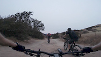
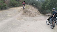
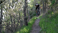
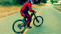
Photos of Atascadero Mountain Bike
Videos of Atascadero Mountain Bike
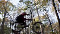
trail: Rocky Canyon Trail
2:51 |
57 |
Sep 13, 2020
trail: Rocky Canyon Trail
0:13 |
107 |
Sep 13, 2020

2:27 |
91 |
Oct 2, 2019
0:45 |
131 |
Feb 6, 2019
trail: Pine Mountain Loop
2:09 |
651 |
Sep 11, 2017
trail: Blue Oak Trail
0:42 |
477 |
Dec 19, 2016
trail: Rocky Canyon Trail
2:57 |
313 |
Aug 3, 2016
trail: Rocky Canyon Trail
13:46 |
287 |
May 13, 2022 , Atascadero
Recent Trail Reports
| status | trail | date | condition | info | user |
|---|---|---|---|---|---|
| Meadow Trail | Apr 18, 2026 @ 12:10pm (America/Los_Angeles) Apr 18, 2026 | Ideal | Arcrangeride | ||
| Oak Woodland Loop Left | Apr 18, 2026 @ 12:10pm (America/Los_Angeles) Apr 18, 2026 | Ideal | Arcrangeride | ||
| Oak Woodland Loop Right | Apr 18, 2026 @ 12:10pm (America/Los_Angeles) Apr 18, 2026 | Ideal | Arcrangeride | ||
| Rocky Canyon Trail | Mar 17, 2026 @ 1:59pm (America/Los_Angeles) Mar 17, 2026 | Unknown | JBs3ot | ||
| Pine Mountain Loop | Jan 1, 2026 @ 7:38am (America/Los_Angeles) Jan 1, 2026 | Ideal | Jack629 | ||
| Blue Oak Trail | Jan 1, 2026 @ 7:38am (America/Los_Angeles) Jan 1, 2026 | Ideal | Jack629 | ||
| Blue Oak Access Trail | Dec 26, 2025 @ 4:17pm (America/Los_Angeles) Dec 26, 2025 | Wet | DK805and808 | ||
| Lookout Trail | Nov 30, 2025 @ 7:05am (America/Los_Angeles) Nov 30, 2025 | Wet | DK805and808 | ||
| BVJT | Dec 5, 2022 @ 6:34am Dec 5, 2022 | Wet | Peterhouse26 | ||
| Heilmann Access | Dec 4, 2021 @ 8:36am Dec 4, 2021 | Dry | Peterhouse26 |
Activity Feed
| username | action | type | title | date |
|---|---|---|---|---|
| RacerGDLvXM | wishlist | trail | activity #96536041 | Jun 8, 2026 @ 6:46am Jun 8, 2026 |
| Arcrangeride | add | report | activity #92897355 and 2 more | Apr 18, 2026 @ 3:14pm Apr 18, 2026 |
| JBs3ot | add | report | activity #90761770 | Mar 17, 2026 @ 1:59pm Mar 17, 2026 |
| JBs3ot | add | report | activity #90086989 | Mar 6, 2026 @ 3:20pm Mar 6, 2026 |
| JBs3ot | add | report | activity #89647708 | Feb 27, 2026 @ 1:40pm Feb 27, 2026 |
Recent Comments
| username | type | title | comment | date |
|---|---|---|---|---|
| trail | Fun multiple loop ride for elevation &... | Feb 4, 2021 @ 8:08pm Feb 4, 2021 | ||
| trail | Mild warm up loop ride. Watch for hikers. ... | Feb 4, 2021 @ 8:06pm Feb 4, 2021 | ||
| trail | Quick but steep climb. Multiple DH jump... | Feb 4, 2021 @ 8:04pm Feb 4, 2021 | ||
| trail | Nice simple trail. Good steady climb. | Sep 3, 2019 @ 10:05am Sep 3, 2019 | ||
| trail | Great trail. Good to work on not so extreme... | Sep 3, 2019 @ 10:04am Sep 3, 2019 |
Local Badges
-

Epic Mountain Bike Climb 2k71 awarded -

Climbing 10k Badge18 awarded -

Mountain Biking 100k Badge1 awarded -

Epic Ride Descent 2k71 awarded -

Descent 10k Badge18 awarded -

Descent 100k Badge1 awarded
Activity Type Stats
| activitytype | trails | distance | descent | descent distance | total vertical | rating | global rank | state rank | photos | reports | routes | ridelogs |
|---|---|---|---|---|---|---|---|---|---|---|---|---|
| Mountain Bike | 18 | 11 miles | 2,844 ft | 6 miles | 807 ft | #6,424 | #2,167 | 56 | 169 | 6,723 | ||
| E-Bike | 1 | 146 | 298 | |||||||||
| Horse | 9 | 1 mile | 374 ft | 4,491 ft | 328 ft | #3,101 | #1,762 | 12 | ||||
| Hike | 22 | 11 miles | 2,844 ft | 6 miles | 807 ft | #7,921 | #2,798 | 162 | 1,340 | |||
| Trail Running | 22 | 11 miles | 2,844 ft | 6 miles | 807 ft | #8,893 | #2,983 | 162 | 253 |
Frequently Asked Questions About Atascadero
▼
What are the best places to ride in Atascadero?
Atascadero has 4 areas to explore for mountain biking. The top rated areas are:
▼
What are the highest rated mountain biking trails in Atascadero?
The highest rated mountain biking trails in Atascadero are:
- Jim Green Loop (3.8/5)
- Pine Mountain Loop (3.7/5)
- Meadow Trail (3.7/5)
- Blue Oak Trail (3.7/5)
- Lookout Trail (3.7/5)
▼
What is the best time of the year to ride in Atascadero?
Based on ride log data, the most popular months to ride in Atascadero are:
- May (21 activities)
- April (19 activities)
- February (18 activities)
▼
Where can I park to ride in Atascadero?
There are 1 parking locations listed in Atascadero. The most popular parking spots are:
Activities
Trails
Points of Interest
- By seanharanmtb & contributors
- Admins: CCCMB
- #17731 - 9,079 views
- atascadero activity log | embed map of Atascadero mountain bike trails | atascadero mountain biking points of interest
Downloading of trail gps tracks in kml & gpx formats is enabled for Atascadero.
You must login to download files.