close
-
Layers w
- Weather Layers
- Pro
- Pro
- Pro
- Pro
- Pro
- Pro
- More Layers
- Pro
- Pro
- Pro
- Pro
-
Upgrade to

3D
Trail Conditions
- Unknown
- Snow Groomed
- Snow Packed
- Snow Covered
- Snow Cover Partial
- Freeze/thaw Cycle
- Icy
- Prevalent Mud
- Wet
- Variable
- Ideal
- Dry
- Very Dry
Trail Flow (Ridden Direction)
Trailforks scans users ridelogs to determine the most popular direction each trail is ridden. A good flowing trail network will have most trails flowing in a single direction according to their intension.
The colour categories are based on what percentage of riders are riding a trail in its intended direction.
The colour categories are based on what percentage of riders are riding a trail in its intended direction.
- > 96%
- > 90%
- > 80%
- > 70%
- > 50%
- < 50%
- bi-directional trail
- no data
Trail Last Ridden
Trailforks scans ridelogs to determine the last time a trail was ridden.
- < 2 days
- < 1 week
- < 2 weeks
- < 1 month
- < 6 months
- > 6 months
Trail Ridden Direction
The intended direction a trail should be ridden.
- Downhill Only
- Downhill Primary
- Both Directions
- Uphill Primary
- Uphill Only
- One Direction
Contribute Details
Colors indicate trail is missing specified detail.
- Description
- Photos
- Description & Photos
- Videos
Trail Popularity ?
Trailforks scans ridelogs to determine which trails are ridden the most in the last 9 months.
Trails are compared with nearby trails in the same city region with a possible 25 colour shades.
Think of this as a heatmap, more rides = more kinetic energy = warmer colors.
- most popular
- popular
- less popular
- not popular
ATV/ORV/OHV Filter
Max Vehicle Width
inches
US Cell Coverage
Legend

Radar Time
Activity Recordings
Trailforks uses anonymized public activity data.
?
Activity Recordings
Trailforks uses anonymized public activity data.
?
Personal Heatmap
▶
Activity Types
all
/
none
▶
Options
2
Date range
month
–
Winter Trails
Warning
A routing network for winter maps does not exist. Selecting trails using the winter trails layer has been disabled.
Missing Trails
Most Popular
Least Popular
Trails are colored based on popularity. The more popular a trail is, the more red. Less popular trails trend towards green.
Jump Magnitude Heatmap
Heatmap of where riders jump on trails. Zoom in to see individual jumps, click circles to view jump details.
BC Backroad Status
![map legend]()
Service Road Atlas is a free to use, community-driven service for viewing and creating reports on the numerous back-country service roads around B.C. and Alberta.

Slope Aspect
Direction the slope faces
Trails Deemphasized
Trails are shown in grey.
Only show trails with no bike usage.
Suggested Layers
Based on selected activity type
Save the current map location and zoom level as your default home location whenever this page is loaded.
Save
No description for Atherton has been added yet!
Login or register to submit one.
Activities Click to view
- Mountain Bike
34 trails
- E-Bike
29 trails
- Adaptive Bike
0 trails
- Winter Fat Bike
0 trails
- Horse
10 trails
- Hike
17 trails
- Trail Running
16 trails
Region Details
- 10
- 1
- 8
- 15
Region Status
Open as of Jun 12, 2026Stats
- Avg Trail Rating
- Trails (view details)
- 38
- Trails Mountain Bike
- 34
- Trails E-Bike
- 29
- Trails Horse
- 10
- Trails Hike
- 17
- Trails Trail Running
- 16
- Trails Dirtbike/Moto
- 1
- Total Distance
- 81 miles
- Total Descent
- 13,947 ft
- Total Vertical
- 2,121 ft
- Highest Trailhead
- 4,071 ft
- Reports
- 508
- Photos
- 147
- Ridden Counter
- 6,472
Sub Regions
-
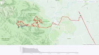
Atherton Forest Mountain Bike Park
- 7
- 15
-
Herberton Range
- 1
Popular Atherton Mountain Biking Trails
• 85 ★ 3.7 • 4 miles • 510 ft • 409 •
Nicknamed because it was the first true mountain bike trail to be constructed on the Atherton Tablelands, this iconic trail created mountain biking excitement in Atherton. It is great fun and challenging with exciting climbs and even...
• 100 ★ 0.0 • 2,395 ft • 15 ft • 397 •
Popular green difficulty singletrack. This mountain bike primary trail can be used downhill primary and has a easy overall physical rating. On average it takes 3 minutes to complete this trail.
• 95 ★ 4.2 • 2 miles • 56 ft • 372 •
A trail that has a bit of everything and is a joy to ride. Best to ride a couple of times and familiarize to extract the most fun as some of the features and jumps are hidden but if you know they're coming up ahead its worth putting in...
• 80 ★ 3.0 • 4,304 ft • 47 ft • 300 •
Named in honor of a section of trail that no longer exists that was originally built by a local Kiwi lad. The trail roughly follows the old trail “Kiwi loop”. A fast, fun ride all the way out to the gate at the trail head. Look out...
• 90 ★ 4.0 • 4,413 ft • 55 ft • 277 •
Rocky terrain, decent flow and a good view of the valley below if you dare look left.
• 65 ★ 5.0 • 3,823 ft • 54 ft • 242 •
The trail follows the creek for about 1.5km before popping out on Rifle Range Road an easy 1.5km ride from the trail head proper of AFMTBP. It then continues as a green graded trail in the park proper with various other trails leading...
Atherton Mountain Bike Routes
39 miles • 3,342 ft • 7 •
Lap from Big 4 though the hills and then looping around the Atherton trail park
26 miles • 3,997 ft • 12 •
Climb 1000m in one ride at Atherton Forest MTB Park. the name says it all really... Bring your mountain legs.
1 mile • 34 ft • 0 • Point to Point •
Single track from Mt Ida. Exit near the back of the historical village via the train tracks
6 miles • 612 ft • 5 • Loop • Race •
ELEV8XCM is the signature event staged annually by Tableland Cycle Sports Inc. It is a cross country style...
• 14 miles • 1,451 ft • 10 •
• 3 miles • 251 ft • 2 •
Photos of Atherton Mountain Bike
Videos of Atherton Mountain Bike

trail: Trail 13 (Yahoo Wahoo)
10:16 |
235 |
Oct 2, 2018

trail: Trail 9 (Ricochet)
3:33 |
587 |
Oct 4, 2016

trail: Trail 1
5:49 |
1935 |
Jan 20, 2015

trail: Trail 13 (Yahoo Wahoo)
26:51 |
408 |
Sep 11, 2021 , Atherton
trail: Trail 9 (Ricochet)
26:51 |
547 |
Sep 11, 2021 , Atherton
Recent Trail Reports
| status | trail | date | condition | info | user |
|---|---|---|---|---|---|
| Trail 15 | Jun 12, 2026 @ 5:25pm (Australia/Lindeman) Jun 12, 2026 | Ideal | BenSellers | ||
| Trail 1 | Jun 12, 2026 @ 5:25pm (Australia/Lindeman) Jun 12, 2026 | Ideal | BenSellers | ||
| Trail 6 (Ridgey Didge) | Jun 12, 2026 @ 5:25pm (Australia/Lindeman) Jun 12, 2026 | Ideal | BenSellers | ||
| Trail 1 (Race Entrance) | Jun 12, 2026 @ 5:25pm (Australia/Lindeman) Jun 12, 2026 | Ideal | BenSellers | ||
| Trail 7 (Bandy Bandy) | May 16, 2026 @ 7:03am (Australia/Brisbane) May 15, 2026 | Unknown | dpret3 TCS | ||
| Trail 9 (Ricochet) | May 10, 2026 @ 7:36am (Australia/Brisbane) May 9, 2026 | Unknown | dpret3 TCS | ||
| Trail 8 (Hack) | Apr 4, 2026 @ 6:08pm (Australia/Brisbane) Apr 4, 2026 | Unknown | dpret3 TCS | ||
| Trail 5 | Apr 4, 2026 @ 6:08pm (Australia/Brisbane) Apr 4, 2026 | Unknown | dpret3 TCS | ||
| Trail 4 Link | Apr 4, 2026 @ 6:08pm (Australia/Brisbane) Apr 4, 2026 | Unknown | dpret3 TCS | ||
| Trail 4 (Alternate) | Apr 4, 2026 @ 6:08pm (Australia/Brisbane) Apr 4, 2026 | Unknown | dpret3 TCS |
Activity Feed
| username | action | type | title | date |
|---|---|---|---|---|
| BenSellers | add | report | activity #96792395 and 3 more | Jun 12, 2026 @ 3:32am Jun 12, 2026 |
| OmarK | comment | trail | activity #96055979 | Jun 1, 2026 @ 6:41pm Jun 1, 2026 |
| OmarK | vote | trail | activity #96055915 | Jun 1, 2026 @ 6:40pm Jun 1, 2026 |
| dpret3 | add | report | activity #95802665 | May 29, 2026 @ 2:32pm May 29, 2026 |
| RenataLzuPIE | wishlist | trail | activity #95743048 and 2 more | May 28, 2026 @ 5:03pm May 28, 2026 |
Recent Comments
| username | type | title | comment | date |
|---|---|---|---|---|
| trail | June 2026. Cliffhanger has just had a refurb... | Jun 1, 2026 @ 6:41pm Jun 1, 2026 | ||
| trail | This is not an MTB trail, trail usage data... | Jul 3, 2025 @ 2:43pm Jul 3, 2025 | ||
| trail | Whatch out for a snake at the rock gardens at... | May 31, 2025 @ 4:14pm May 31, 2025 | ||
| trail | Definitely needs to be broken into sections.... | Mar 17, 2025 @ 12:31am Mar 17, 2025 | ||
| trail | Needs serious maintenance and upgrades. Not... | Mar 17, 2025 @ 12:27am Mar 17, 2025 |
Local Badges
-

10 Blue Trails119 awarded -

Epic Ride Climb 2k41 awarded -

Climbing 10k Badge35 awarded -

Climbing 100k Badge4 awarded -

Epic Ride Descent 2k42 awarded -

Descent 10k Badge36 awarded
Activity Type Stats
| activitytype | trails | distance | descent | descent distance | total vertical | rating | global rank | state rank | photos | reports | routes | ridelogs |
|---|---|---|---|---|---|---|---|---|---|---|---|---|
| Mountain Bike | 34 | 77 miles | 13,858 ft | 42 miles | 2,119 ft | #2,364 | #110 | 145 | 508 | 4 | 8,507 | |
| E-Bike | 29 | 69 miles | 10,630 ft | 35 miles | 2,119 ft | #2,307 | #113 | 2 | 501 | 2 | 744 | |
| Horse | 10 | 30 miles | 8,018 ft | 18 miles | 1,555 ft | #1,099 | #52 | 81 | ||||
| Hike | 17 | 45 miles | 5,709 ft | 23 miles | 2,119 ft | #4,810 | #145 | 459 | 1 | 397 | ||
| Trail Running | 16 | 44 miles | 4,882 ft | 22 miles | 2,119 ft | #4,401 | #132 | 459 | 240 | |||
| Dirtbike/Moto | 1 | 5 miles | 1,273 ft | 3 miles | 1,102 ft | 81 | 38 |
Frequently Asked Questions About Atherton
▼
What are the best places to ride in Atherton?
Atherton has 2 areas to explore for mountain biking. The top rated areas are:
▼
What are the highest rated mountain biking trails in Atherton?
The highest rated mountain biking trails in Atherton are:
- Trail 1 (4.2/5)
- Lickety Split (4.1/5)
- Trail 13 (Yahoo Wahoo) (4.1/5)
- Trail 5 (4/5)
- Trail 17 (Drop Zone) (4/5)
▼
What is the best time of the year to ride in Atherton?
Based on ride log data, the most popular months to ride in Atherton are:
- July (100 activities)
- October (55 activities)
- August (44 activities)
▼
Where can I park to ride in Atherton?
There are 2 parking locations listed in Atherton. The most popular parking spots are:
Activities
Trails
- By brenthillier
 NSMBA TRAILFORKS & contributors
 - Admins: TCS
- #4662 - 7,675 views
- atherton activity log | embed map of Atherton mountain bike trails | atherton mountain biking points of interest
Downloading of trail gps tracks in kml & gpx formats is enabled for Atherton.
You must login to download files.