close
-
Layers w
- Weather Layers
- Pro
- Pro
- Pro
- Pro
- Pro
- Pro
- More Layers
- Pro
- Pro
- Pro
- Pro
-
Upgrade to

3D
Trail Conditions
- Unknown
- Snow Groomed
- Snow Packed
- Snow Covered
- Snow Cover Partial
- Freeze/thaw Cycle
- Icy
- Prevalent Mud
- Wet
- Variable
- Ideal
- Dry
- Very Dry
Trail Flow (Ridden Direction)
Trailforks scans users ridelogs to determine the most popular direction each trail is ridden. A good flowing trail network will have most trails flowing in a single direction according to their intension.
The colour categories are based on what percentage of riders are riding a trail in its intended direction.
The colour categories are based on what percentage of riders are riding a trail in its intended direction.
- > 96%
- > 90%
- > 80%
- > 70%
- > 50%
- < 50%
- bi-directional trail
- no data
Trail Last Ridden
Trailforks scans ridelogs to determine the last time a trail was ridden.
- < 2 days
- < 1 week
- < 2 weeks
- < 1 month
- < 6 months
- > 6 months
Trail Ridden Direction
The intended direction a trail should be ridden.
- Downhill Only
- Downhill Primary
- Both Directions
- Uphill Primary
- Uphill Only
- One Direction
Contribute Details
Colors indicate trail is missing specified detail.
- Description
- Photos
- Description & Photos
- Videos
Trail Popularity ?
Trailforks scans ridelogs to determine which trails are ridden the most in the last 9 months.
Trails are compared with nearby trails in the same city region with a possible 25 colour shades.
Think of this as a heatmap, more rides = more kinetic energy = warmer colors.
- most popular
- popular
- less popular
- not popular
ATV/ORV/OHV Filter
Max Vehicle Width
inches
US Cell Coverage
Legend

Radar Time
Activity Recordings
Trailforks uses anonymized public activity data.
?
Activity Recordings
Trailforks uses anonymized public activity data.
?
Personal Heatmap
▶
Activity Types
all
/
none
▶
Options
2
Date range
month
–
Winter Trails
Warning
A routing network for winter maps does not exist. Selecting trails using the winter trails layer has been disabled.
Missing Trails
Most Popular
Least Popular
Trails are colored based on popularity. The more popular a trail is, the more red. Less popular trails trend towards green.
Jump Magnitude Heatmap
Heatmap of where riders jump on trails. Zoom in to see individual jumps, click circles to view jump details.
BC Backroad Status
![map legend]()
Service Road Atlas is a free to use, community-driven service for viewing and creating reports on the numerous back-country service roads around B.C. and Alberta.

Slope Aspect
Direction the slope faces
Trails Deemphasized
Trails are shown in grey.
Only show trails with no bike usage.
Suggested Layers
Based on selected activity type
Save the current map location and zoom level as your default home location whenever this page is loaded.
Save
No description for Atlanta has been added yet!
Login or register to submit one.
Activities Click to view
- Mountain Bike
73 trails
- E-Bike
19 trails
- Adaptive Bike
0 trails
- Winter Fat Bike
1 trails
- Hike
101 trails
- Trail Running
101 trails
Region Details
- 23
- 6
- 18
- 16
- 2
Region Status
Open as of May 25, 2026Stats
- Avg Trail Rating
- Trails (view details)
- 71
- Trails Mountain Bike
- 75
- Trails E-Bike
- 19
- Trails Gravel Bike
- 2
- Trails Winter Fat Bike
- 1
- Trails Hike
- 101
- Trails Trail Running
- 101
- Total Distance
- 38 miles
- Total Descent
- 2,707 ft
- Total Vertical
- 291 ft
- Highest Trailhead
- 1,059 ft
- Reports
- 483
- Photos
- 126
- Ridden Counter
- 12,237
Sub Regions
-
Aerotropolis Nature Park
- 5
- 3
-
Atlanta Beltline
- 6
- 2
-
Bennington Park
-
Bike Park at Westside Park
-
Campbellton Creek Nature Park
-
Cascade Springs Nature Preserve
- 4
-
Lionel Hampton-Beecher Nature Preserve
- 2
- 1
-
Morningside Nature preserve
- 5
-
Southside Park
- 2
- 4
- 2
-
Sykes Park
- 1
- 2
Popular Atlanta Mountain Biking Trails
• 100 ★ 4.3 • 1 mile • 71 ft • 269 •
Popular green difficulty singletrack. This mountain bike primary trail can be used both directions and has a moderate overall physical rating with a 71 ft green climb. On average it takes 8 minutes to complete this trail.
• 95 ★ 4.2 • 3 miles • 183 ft • 251 •
Popular blue difficulty singletrack. This multi-use trail can be used both directions and has a moderate overall physical rating with a 183 ft blue climb. It features berm, bridge, rock garden and skinny. On average it takes 21 minutes to complete this trail.
• 100 ★ 5.0 • 2 miles • 161 ft • 209 •
The is a blue trail with two black expert lines at the Southside Park System. This trail has challenging hand built rock features and tread. There is a great flowy downhill and a some good climbs. All features have ride arounds. Ride...
• 100 ★ 3.5 • 623 ft • 33 ft • 194 •
Popular white difficulty paved path. This mountain bike primary trail can be used both directions. On average it takes minutes to complete this trail.
• 5 ★ 0.0 • 4 miles • 70 ft • 141 •
https://beltline.org/places-to-go/southside-trail/
• 90 ★ 4.0 • 840 ft • 3 ft • 139 •
Shortcut access across the grass from the parking lot to get the goods
• 95 ★ 5.0 • 1,329 ft • 14 ft • 133 •
Expert alternate line on the featuring several technical rock sections.
• 95 ★ 0.0 • 1,421 ft • 10 ft • 128 •
Popular blue difficulty singletrack. This multi-use trail can be used both directions and has a moderate overall physical rating with a 10 ft blue climb. Trail visibility is always easy to follow. On average it takes 2 minutes to complete this trail.
Atlanta Mountain Bike Routes
Photos of Atlanta Mountain Bike
Videos of Atlanta Mountain Bike

trail: Powerline Connect
0:26 |
249 |
Oct 16, 2021 , Atlanta

trail: Oak Trail
9:19 |
448 |
Oct 14, 2021 , Atlanta

trail: Hickory Trail
6:51 |
406 |
Oct 13, 2021 , Atlanta

trail: North Connector
4:52 |
241 |
Oct 12, 2021 , Atlanta
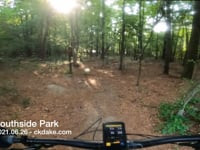
trail: Hickory Trail
5:00 |
392 |
Jun 26, 2021 , Atlanta
Recent Trail Reports
Activity Feed
| username | action | type | title | date |
|---|---|---|---|---|
| willhf1011 | wishlist | region | activity #97162793 | Jun 16, 2026 @ 10:08pm Jun 16, 2026 |
| willhf1011 | wishlist | region | activity #97162783 | Jun 16, 2026 @ 10:07pm Jun 16, 2026 |
| WillieJacobsz | update | region | activity #97108565 | Jun 16, 2026 @ 7:26am Jun 16, 2026 |
| WillieJacobsz | update | region | activity #97106582 | Jun 16, 2026 @ 6:54am Jun 16, 2026 |
| WillieJacobsz | update | region | activity #97106148 | Jun 16, 2026 @ 6:47am Jun 16, 2026 |
Recent Comments
| username | type | title | comment | date |
|---|---|---|---|---|
| report | Ignore this picture: the picture is from/on... | Jan 16, 2026 @ 3:05pm Jan 16, 2026 | ||
| report | Trail fairly wet. Rocks slick but no puddles... | Oct 7, 2025 @ 10:03am Oct 7, 2025 | ||
| report | Probably 24” in diameter. Just downhill from... | Jul 23, 2025 @ 3:01pm Jul 23, 2025 | ||
| trail | The better of the two tech trails here IMO. It... | Mar 20, 2025 @ 3:21am Mar 20, 2025 | ||
| trail | One of the two advanced tech routes. This on... | Mar 20, 2025 @ 3:18am Mar 20, 2025 |
Local Badges
-

10 Green Trails243 awarded -

Epic Ride Climb 2k20 awarded -

Climbing 10k Badge160 awarded -

Climbing 100k Badge13 awarded -

Epic Ride Descent 2k21 awarded -

Descent 10k Badge161 awarded
Activity Type Stats
| activitytype | trails | distance | descent | descent distance | total vertical | rating | global rank | state rank | photos | reports | routes | ridelogs |
|---|---|---|---|---|---|---|---|---|---|---|---|---|
| Mountain Bike | 73 | 35 miles | 2,398 ft | 12 miles | 266 ft | #2,894 | #1,027 | 86 | 483 | 1 | 25,446 | |
| E-Bike | 19 | 2 miles | 164 ft | 3,245 ft | 105 ft | #7,090 | #2,138 | 391 | 1 | 1,084 | ||
| Gravel Bike | 2 | #627 | #355 | 1 | 112 | |||||||
| Winter Fat Bike | 1 | #355 | #1,111 | |||||||||
| Hike | 101 | 38 miles | 2,707 ft | 13 miles | 292 ft | #774 | #352 | 39 | 483 | 965 | ||
| Trail Running | 101 | 38 miles | 2,707 ft | 13 miles | 292 ft | #3,804 | #1,135 | 483 | 1,896 |
Frequently Asked Questions About Atlanta
▼
What are the best places to ride in Atlanta?
Atlanta has 13 areas to explore for mountain biking. The top rated areas are:
▼
What are the highest rated mountain biking trails in Atlanta?
The highest rated mountain biking trails in Atlanta are:
- Hickory Trail (4.2/5)
- Soapstone Ridge Alternate (4.1/5)
- Moontower (4.1/5)
- Evergreen Trail (4.1/5)
- Oak Trail (4.1/5)
▼
What is the best time of the year to ride in Atlanta?
Based on ride log data, the most popular months to ride in Atlanta are:
- July (62 activities)
- September (52 activities)
- October (46 activities)
▼
Where can I park to ride in Atlanta?
There are 16 parking locations listed in Atlanta. The most popular parking spots are: View all parking and trailhead locations on the map to plan your visit.
Activities
Trails
Points of Interest
- By dickeysezso & contributors
- Admins: NGMBA
- #6243 - 15,415 views
- atlanta activity log | embed map of Atlanta mountain bike trails | atlanta mountain biking points of interest
Downloading of trail gps tracks in kml & gpx formats is enabled for Atlanta.
You must login to download files.