close
-
Layers w
- Weather Layers
- Pro
- Pro
- Pro
- Pro
- Pro
- Pro
- More Layers
- Pro
- Pro
- Pro
- Pro
-
Upgrade to

3D
Trail Conditions
- Unknown
- Snow Groomed
- Snow Packed
- Snow Covered
- Snow Cover Partial
- Freeze/thaw Cycle
- Icy
- Prevalent Mud
- Wet
- Variable
- Ideal
- Dry
- Very Dry
Trail Flow (Ridden Direction)
Trailforks scans users ridelogs to determine the most popular direction each trail is ridden. A good flowing trail network will have most trails flowing in a single direction according to their intension.
The colour categories are based on what percentage of riders are riding a trail in its intended direction.
The colour categories are based on what percentage of riders are riding a trail in its intended direction.
- > 96%
- > 90%
- > 80%
- > 70%
- > 50%
- < 50%
- bi-directional trail
- no data
Trail Last Ridden
Trailforks scans ridelogs to determine the last time a trail was ridden.
- < 2 days
- < 1 week
- < 2 weeks
- < 1 month
- < 6 months
- > 6 months
Trail Ridden Direction
The intended direction a trail should be ridden.
- Downhill Only
- Downhill Primary
- Both Directions
- Uphill Primary
- Uphill Only
- One Direction
Contribute Details
Colors indicate trail is missing specified detail.
- Description
- Photos
- Description & Photos
- Videos
Trail Popularity ?
Trailforks scans ridelogs to determine which trails are ridden the most in the last 9 months.
Trails are compared with nearby trails in the same city region with a possible 25 colour shades.
Think of this as a heatmap, more rides = more kinetic energy = warmer colors.
- most popular
- popular
- less popular
- not popular
ATV/ORV/OHV Filter
Max Vehicle Width
inches
US Cell Coverage
Legend

Radar Time
Activity Recordings
Trailforks uses anonymized public activity data.
?
Activity Recordings
Trailforks uses anonymized public activity data.
?
Personal Heatmap
▶
Activity Types
all
/
none
▶
Options
2
Date range
month
–
Winter Trails
Warning
A routing network for winter maps does not exist. Selecting trails using the winter trails layer has been disabled.
Missing Trails
Most Popular
Least Popular
Trails are colored based on popularity. The more popular a trail is, the more red. Less popular trails trend towards green.
Jump Magnitude Heatmap
Heatmap of where riders jump on trails. Zoom in to see individual jumps, click circles to view jump details.
BC Backroad Status
![map legend]()
Service Road Atlas is a free to use, community-driven service for viewing and creating reports on the numerous back-country service roads around B.C. and Alberta.

Slope Aspect
Direction the slope faces
Trails Deemphasized
Trails are shown in grey.
Only show trails with no bike usage.
Suggested Layers
Based on selected activity type
Save the current map location and zoom level as your default home location whenever this page is loaded.
SavePopular Trail Networks
view all areas »
No description for Australia has been added yet!
Login or register to submit one.
Links
Stats
- Avg Trail Rating
- Trails (view details)
- 23,219
- Trails Mountain Bike
- 18,743
- Trails E-Bike
- 13,426
- Trails Gravel Bike
- 2,363
- Trails Adaptive Bike
- 3,207
- Trails Winter Fat Bike
- 1,261
- Trails Horse
- 1,526
- Trails Hike
- 17,620
- Trails Trail Running
- 17,695
- Trails Dirtbike/Moto
- 973
- Trails Observed Trials
- 28
- Trails ATV/ORV/OHV
- 687
- Trails Snowmobile
- 8
- Trails Snowshoe
- 113
- Trails Downhill Ski
- 266
- Trails Backcountry Ski
- 269
- Trails Nordic Ski
- 130
- Total Distance
- 30,441 miles
- Total Descent
- 752 miles
- Total Vertical
- 34,416 ft
- Highest Trailhead
- 34,416 ft
- Reports
- 191,603
- Photos
- 52,928
- Ridden Counter
- 4,086,737
Articles

Oceania Mountain Bike Championships
Feb 25, 2003 from pinkbike.com
The Oceania Mountain Bike Championships took place recently at Eildon in Victoria on February 22-23, 2003. Essentially it was a challenge between...
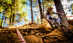
Kona Factory Team Australia - National Series Round 3 by Lube
Apr 6, 2026 from pinkbike.com
Check out Australia's fastest racers going flat out at. We can't wait to see Hill, Kovarik, and Fearon race more this season.

Video: Australian MTB National Series Round 2 - Mt Buller
Feb 9, 2014 from pinkbike.com
A raw edit from the Australian National Series at Mt Buller this weekend.
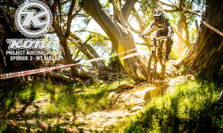
Kona Project 2014: Episode 2 - Mt. Buller
Feb 11, 2014 from pinkbike.com
Ups and downs from the Kona Factory Team Australia at the 2014 National Round 2.
Sub Regions
- Australian Capital Territory (ACT) (865)
- New South Wales (5,845)
- Northern Territory (287)
- Queensland (3,000)
- South Australia (1,505)
- Tasmania (1,588)
- Victoria (4,160)
- Western Australia (564)
Popular Australia Mountain Biking Trails
• 100 ★ 3.5 • 2 miles • 196 ft • 3,982 •
An essential part of the valley trail network. This track was an alternative to the old track. It's now a favorite way in and out for many riders.
• 100 ★ 4.7 • 2,572 ft • 2 ft • 3,569 •
Take this trail almost any day in the hour before sunset and you'll be riding through kangaroos. They eat the grass that this track runs over. Maybe it should be renamed Kangaroo View? The trail itself has a couple of challenging...
• 100 ★ 3.9 • 2,172 ft • 43 ft • 3,392 •
Most of this trail is a firetrail in between the beginning and end singletrack portions. The fast run down the firetrail back into the trees often catches people out in too high a gear as they go into the trees and uphill. A couple of...
• 100 ★ 4.5 • 518 ft • 20 ft • 3,382 •
Adjacent to the Cascade River, is an area or 'trailhead' rather than a trail. Many trails head off from, and into, . The western side has access to and while the eastern side accesses and . The two sides are separated by a small green...
• 100 ★ 4.6 • 1,706 ft • 6 ft • 3,325 •
At low speed this is an incredibly benign beginner's descent. At high speeds there are numerous jumps where the key to a good time is catching perfect backside. Going straight ahead at the big left handed berm (yes, over the back of the...
• 100 ★ 4.0 • 4,285 ft • 13 ft • 3,223 •
One of Daisy Hill's most popular trails. Flowy, one-direction singletrack with plenty of berms and pump sections across its 1.4km.
• 100 ★ 4.1 • 2,047 ft • 74 ft • 3,215 •
Passing through boulder fields and dense Eucalypt forests before crossing the Cascade River this trail is gentle and mostly descending back towards Derby township.
Australia Mountain Bike Routes
Remarkable Epic Trail Featured
★ 5.0 • 24 miles • 3,651 ft • 6 • Loop •
The Remarkable Epic Trail route is the premier South Australian backcountry experience and explores remote...
Red Arrow 20km Loop Featured
★ 5.0 • 12 miles • 1,016 ft • 24 • Loop •
This 20km loop is a very good loop for the average MTB rider. The loop is mostly made up of easy to...
Majura Pines Green Loop Featured
★ 5.0 • 3 miles • 291 ft • 11 •
If you have conquered and , why not try the longer, slightly harder Green Loop. Proceed through the...
Red Arrow 20km Loop (Alternate) Featured
★ 5.0 • 12 miles • 986 ft • 26 • Loop •
Alternate 20km Loop includes , Oscar & Archie and the full length of . This 20km loop is a very good...
K9 Featured
★ 5.0 • 5 miles • 563 ft • 15 • Loop •
The K9 Loop is approximately 9-10 klms long with the tracks generally rated between green and blue with...
Blue Arrow 10km Loop Featured
★ 5.0 • 6 miles • 505 ft • 7 • Loop •
A nice 10km loop to give you a great introduction to Jolly Nose. Great for the whole family. Follow the...
Photos of Australia Mountain Bike
Videos of Australia Mountain Bike
featured
![State Downhill Series 2018]()

trail: Wheel Nuts
0:44 |
227 |
Apr 1, 2019
featured
![Explore the Illawarra mountain bike network,...]()

3:03 |
175 |
Sep 4, 2025
featured
![Didn’t Expect THIS on My E-Bike Ride…]()

trail: North-South CLIMB
488 |
Jun 9, 2025 , Hobart
featured
![Gravity Uplift & Check-in for Mystic Bike...]()

0:04 |
167 |
Nov 17, 2024
featured
![Flowmingo | Mystic Bike Park | GoPRO Trail Of...]()
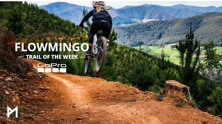
trail: Lower Flowmingo
4:51 |
534 |
Nov 7, 2024 , Bright
featured
![Mystic Mountain Bike Park]()

3:01 |
304 |
May 22, 2024
featured
![Shred Kellys last stand]()

trail: Shred Kelly's Last Stand
4:21 |
1536 |
Dec 2, 2018 , Bright
trail: Wallaby Run
0:11 |
19 |
May 24, 2026
National Scenic Trails & Official Routes
-
Munda Biddi Trail
- Mountain Bike
- Hike
- Trail Running
Recent Comments
| username | type | title | comment | date |
|---|---|---|---|---|
| report | Flowy, TBH, it all went by too fast. | Jun 5, 2026 @ 1:43am 3 hours | ||
| report | How the heck can u do that it was at least... | Jun 4, 2026 @ 11:11pm 6 hours | ||
| skillpark | Update, Same old kids track , nothing has... | Jun 4, 2026 @ 9:51pm 7 hours | ||
| report | Thanks for reporting this, the tree has now... | Jun 4, 2026 @ 6:50pm 10 hours | ||
| report | Tree has been cleared, thank you for reporting... | Jun 4, 2026 @ 6:49pm 10 hours |
Bike & Skill Parks
| name | type | city | rating |
|---|---|---|---|
| Mystic Bike Park | bike park | Bright | |
| Stromlo Forest Park | bike park | Canberra | |
| Ourimbah MTB Park | bike park | Wyong | |
| O'Halloran Hill | bike park | Adelaide | |
| Fox Creek Bike Park | bike park | Adelaide |
Upcoming Local Events
-
-
-
-
-
-
-
-
Activity Type Stats
| activitytype | trails | distance | descent | descent distance | total vertical | rating | global rank | state rank | photos | reports | routes | ridelogs |
|---|---|---|---|---|---|---|---|---|---|---|---|---|
| Mountain Bike | 18,743 | 22,296 miles | 2,744,091 ft | 9,849 miles | 34,416 ft | #5 | 50,558 | 191,273 | 2,167 | 4,655,938 | ||
| E-Bike | 13,426 | 17,464 miles | 2,284,514 ft | 7,927 miles | 6,991 ft | #6 | 1,137 | 166,149 | 850 | 401,712 | ||
| Gravel Bike | 2,363 | 3,647 miles | 366,591 ft | 1,438 miles | 34,416 ft | #4 | 36 | 16,673 | 231 | 16,255 | ||
| Adaptive Bike | 3,207 | 5,085 miles | 472,530 ft | 2,069 miles | 34,416 ft | #6 | 2 | 21,304 | 73 | 116 | ||
| Winter Fat Bike | 1,261 | 2,062 miles | 173,678 ft | 893 miles | 6,155 ft | #8 | 4 | 8,870 | 3 | 40 | ||
| Horse | 1,526 | 3,780 miles | 397,969 ft | 1,680 miles | 5,653 ft | #6 | 21 | 41,705 | 43 | 436 | ||
| Hike | 17,620 | 24,646 miles | 2,996,490 ft | 10,602 miles | 34,416 ft | #7 | 839 | 167,999 | 189 | 158,666 | ||
| Trail Running | 17,695 | 24,757 miles | 3,003,609 ft | 10,652 miles | 34,416 ft | #7 | 82 | 168,487 | 472 | 209,901 | ||
| Dirtbike/Moto | 973 | 3,382 miles | 343,366 ft | 1,647 miles | 5,653 ft | #3 | 78 | 35,166 | 36 | 3,162 | ||
| Observed Trials | 28 | 94 miles | 6,903 ft | 36 miles | 3,694 ft | #4 | 28 | 393 | 637 | |||
| ATV/ORV/OHV | 687 | 3,145 miles | 285,410 ft | 1,496 miles | 5,653 ft | #3 | 23 | 34,435 | 26 | 690 | ||
| Snowmobile | 8 | 14 miles | 1,929 ft | 7 miles | 5,157 ft | #9 | 186 | 81 | ||||
| Snowshoe | 113 | 147 miles | 28,235 ft | 74 miles | 7,083 ft | #16 | 11 | 911 | 317 | |||
| Downhill Ski | 266 | 83 miles | 64,423 ft | 72 miles | 6,926 ft | #12 | 13 | 784 | 10,545 | |||
| Backcountry Ski | 269 | 243 miles | 108,012 ft | 151 miles | 7,083 ft | #16 | 1 | 661 | 1,512 | |||
| Nordic Ski | 130 | 156 miles | 22,192 ft | 75 miles | 6,926 ft | #16 | 963 | 2,234 |
Activities
- Australia Mountain Biking Trails
- Australia E-Biking Trails
- Australia Gravel Biking Trails
- Australia Adaptive Biking Trails
- Australia Winter Fat Biking Trails
- Australia Horseback Trails
- Australia Hiking Trails
- Australia Trail Running Trails
- Australia Dirtbiking Trails
- Australia Observed Trials Trails
- Australia ATVing/Offroading Trails
- Australia Snowmobiling Trails
- Australia Snowshoeing Trails
- Australia Skiing Trails
- Australia Backcountry Skiing Trails
- Australia Nordic Skiing Trails
Trails
- By radek
 Trailforks SDBA & contributors
 - Admins: Jake-Hannah, Addzz
- #3098 - 335,187 views
- australia activity log | embed map of Australia mountain bike trails | australia mountain biking points of interest polygons
Downloading of trail gps tracks in kml & gpx formats is enabled for Australia.
You must login to download files.