close
-
Layers w
- Weather Layers
- Pro
- Pro
- Pro
- Pro
- Pro
- Pro
- More Layers
- Pro
- Pro
- Pro
- Pro
-
Upgrade to

3D
Trail Conditions
- Unknown
- Snow Groomed
- Snow Packed
- Snow Covered
- Snow Cover Partial
- Freeze/thaw Cycle
- Icy
- Prevalent Mud
- Wet
- Variable
- Ideal
- Dry
- Very Dry
Trail Flow (Ridden Direction)
Trailforks scans users ridelogs to determine the most popular direction each trail is ridden. A good flowing trail network will have most trails flowing in a single direction according to their intension.
The colour categories are based on what percentage of riders are riding a trail in its intended direction.
The colour categories are based on what percentage of riders are riding a trail in its intended direction.
- > 96%
- > 90%
- > 80%
- > 70%
- > 50%
- < 50%
- bi-directional trail
- no data
Trail Last Ridden
Trailforks scans ridelogs to determine the last time a trail was ridden.
- < 2 days
- < 1 week
- < 2 weeks
- < 1 month
- < 6 months
- > 6 months
Trail Ridden Direction
The intended direction a trail should be ridden.
- Downhill Only
- Downhill Primary
- Both Directions
- Uphill Primary
- Uphill Only
- One Direction
Contribute Details
Colors indicate trail is missing specified detail.
- Description
- Photos
- Description & Photos
- Videos
Trail Popularity ?
Trailforks scans ridelogs to determine which trails are ridden the most in the last 9 months.
Trails are compared with nearby trails in the same city region with a possible 25 colour shades.
Think of this as a heatmap, more rides = more kinetic energy = warmer colors.
- most popular
- popular
- less popular
- not popular
ATV/ORV/OHV Filter
Max Vehicle Width
inches
US Cell Coverage
Legend

Radar Time
Activity Recordings
Trailforks uses anonymized public activity data.
?
Activity Recordings
Trailforks uses anonymized public activity data.
?
Personal Heatmap
▶
Activity Types
all
/
none
▶
Options
2
Date range
month
–
Winter Trails
Warning
A routing network for winter maps does not exist. Selecting trails using the winter trails layer has been disabled.
Missing Trails
Most Popular
Least Popular
Trails are colored based on popularity. The more popular a trail is, the more red. Less popular trails trend towards green.
Jump Magnitude Heatmap
Heatmap of where riders jump on trails. Zoom in to see individual jumps, click circles to view jump details.
BC Backroad Status
![map legend]()
Service Road Atlas is a free to use, community-driven service for viewing and creating reports on the numerous back-country service roads around B.C. and Alberta.

Slope Aspect
Direction the slope faces
Trails Deemphasized
Trails are shown in grey.
Only show trails with no bike usage.
Suggested Layers
Based on selected activity type
Save the current map location and zoom level as your default home location whenever this page is loaded.
SavePopular Trail Networks
view all areas »
No description for Austria has been added yet!
Login or register to submit one.
This region uses the Uk/Euro style trail grading system.
Region Details
- 524
- 235
- 400
- 287
- 144
- 6
Stats
- Avg Trail Rating
- Trails (view details)
- 3,383
- Trails Mountain Bike
- 1,601
- Trails E-Bike
- 1,238
- Trails Gravel Bike
- 147
- Trails Adaptive Bike
- 372
- Trails Winter Fat Bike
- 327
- Trails Horse
- 62
- Trails Hike
- 1,474
- Trails Trail Running
- 1,462
- Trails Dirtbike/Moto
- 8
- Trails Observed Trials
- 7
- Trails ATV/ORV/OHV
- 5
- Trails Snowmobile
- 20
- Trails Snowshoe
- 37
- Trails Downhill Ski
- 850
- Trails Backcountry Ski
- 466
- Trails Nordic Ski
- 34
- Total Distance
- 4,354 miles
- Total Descent
- 1,931,329 ft
- Total Vertical
- 10,928 ft
- Highest Trailhead
- 11,279 ft
- Reports
- 19,562
- Photos
- 8,734
- Ridden Counter
- 372,560
Articles
Inside Leogang's Historic 25th Anniversary World Cup Mega-Festival
Jun 17, 2026 from pinkbike.com
From Jenny Rissveds' dominant cross-country masterclass to Winnie Goldsbury’s enduro triumph, over 800 international athletes battle chaotic...
Bike Republic Sölden Expands for 2026 with New Lines & Smart Connections
May 12, 2026 from pinkbike.com
Get the first look at the redesigned Traien and Ohn Lines ahead of the BRS Festival and season kickoff on June 4.
Women to Headline Leogang DH: New Schedule & Track Details for 2026 World Cup
May 12, 2026 from pinkbike.com
For the first time, Elite Women take center stage as the final event in Austria, alongside a reworked XCO course and a massive Triple Header weekend.
Reader Story: Exploring the High-Alpine Singletrack of Ischgl & Galtür
Apr 20, 2026 from pinkbike.com
Testing the limits of "rideable" on a massive loop through the Austrian-Swiss border and the Jamtal Valley.
Sub Regions
- Burgenland (18)
- Jennersdorf (2)
- Oberpullendorf (1)
- Lockenhaus (1)
- Oberwart (2)
- Eisenstadt (2)
- Jennersdorf (2)
- Kärnten (246)
- Bezirk Völkermarkt (5)
- Bleiburg (5)
- Feldkirchen (15)
- Hermagor (18)
- Hermagor (18)
- Klagenfurt am Wörthersee (28)
- Klagenfurt (28)
- Ossiach (3)
- Spittal an der Drau (6)
- Bad Kleinkirchheim (5)
- Obervellach (2)
- Turracher Höhe (39)
- Turracher Höhe (38)
- Villach (78)
- Villach (78)
- Afritz Am See (1)
- Althofen (5)
- Feistritz ob Bleiburg (1)
- Feld Am See (8)
- Mallnitz (5)
- Millstatt am See (2)
- St. Veit a.d. Glan (2)
- Bezirk Völkermarkt (5)
- Niederösterreich (177)
- Amstetten (2)
- District of Mödling (33)
- Mödling (33)
- Hollabrunn (4)
- Hollabrunn (5)
- Retz (1)
- Krems-Land (17)
- Furth bei Göttweig (17)
- Lilienfeld (15)
- Neunkirchen (67)
- puchberg am schneeberg (9)
- Semmering (11)
- St. Corona am Wechsel (48)
- Sankt Pölten-Land (7)
- Pyhra (8)
- Scheibbs (9)
- Göstling an der Ybbs (5)
- Purgstall (3)
- Scheibbs (1)
- Baden bei Wien (5)
- Bärnkopf (2)
- Bisamberg (3)
- Groß Gerungs (1)
- Hollenstein An Der Ybbs (6)
- Katzelsdorf (2)
- Mauerbach (4)
- Perchtoldsdorf (3)
- Purkersdorf (2)
- Türnitz (5)
- Waidhofen an der Ybbs (3)
- Amstetten (2)
- Oberösterreich (152)
- Freistadt (15)
- Freistadt (14)
- Gmunden (31)
- Bad Goisern (7)
- Ebensee (11)
- Obertraun (15)
- Kirchdorf an der Krems (1)
- Kirchdorf an der Krems (3)
- Spital am Pyhrn (2)
- Windischgarsten (5)
- Linz-Land (2)
- Enns (2)
- Perg (1)
- Perg (5)
- Pyhrn Priel (1)
- Rohrbach (1)
- Rohrbach-Berg (1)
- Urfahr-Umgebung (49)
- Bad Leonfelden (3)
- Vöcklabruck (5)
- Mondsee (5)
- Wels-Land (7)
- Bad Ischl (1)
- Gmunden (4)
- Hochburg-Ach (6)
- Linz (56)
- Maria Schmolln (0)
- Steyr (3)
- Wels (6)
- Freistadt (15)
- Salzburg (120)
- Steiermark (267)
- Bruck-Mürzzuschlag (78)
- Aflenz (8)
- Bruck an der Mur (22)
- Kapfenberg (41)
- Mariazell (7)
- Deutschlandsberg (15)
- Leibnitz (2)
- Leoben (13)
- Liezen (48)
- Bad Aussee (1)
- Schladming (36)
- Murau (6)
- Murtal (20)
- Judenburg (11)
- Knittelfeld (9)
- Südoststeiermark (34)
- Bad Gleichenberg (34)
- Weiz (13)
- Weiz (10)
- Graz (30)
- Judendorf (1)
- Riegersburg (1)
- Bruck-Mürzzuschlag (78)
- Tirol (398)
- Außerfern (50)
- Imst (62)
- Längenfeld (1)
- Nassereith (3)
- Oetz (7)
- Sölden (44)
- Innsbruck (53)
- Innsbruck (58)
- Innsbruck-Land (22)
- Absam (7)
- Neustift (10)
- Seefeld (1)
- Steinach am Brenner (4)
- Zirl (1)
- Kitzbühel (56)
- Brixen im Thale (5)
- Fieberbrunn (9)
- Kirchberg in Tirol (13)
- Kitzbühel (12)
- Oberndorf in Tirol (5)
- Kufstein District (3)
- Landeck (132)
- Fendels (1)
- Galtür (8)
- Ischgl (45)
- Serfaus-Fiss-Ladis (33)
- St. Anton am Arlberg (3)
- Osttirol (16)
- Kals am Großglockner (10)
- Lienz (6)
- Schwaz District (23)
- St. Leonhard im Pitztal (0)
- St.johann in tirol (5)
- Vorarlberg (196)
- Bezirk Feldkirch (59)
- Bludenz (45)
- Bregenz (40)
- Bregenz (23)
- Mittelberg (7)
- Warth (6)
- Dornbirn (46)
- Andelsbuch (4)
- Bürserberg (1)
- Wien (78)
Popular Austria Mountain Biking Trails
• 100 ★ 3.4 • 2 miles • 0 ft • 2,656 •
The is the new route at the last section of the or . It starts right at the mid station of the Westgipfel lift or rather beside the . This flowing and relatively easy trail snakes its way through idyllic landscape shaped by meadows, and...
• 95 ★ 3.3 • 2 miles • 147 ft • 2,629 •
The on the Kohlmais is a beginner-friendly freeride trail for all ages. Thanks to its flow and the magnificent view over Saalbach Hinterglemm, it’s also great for soulriders. Generous berms, wide bends, small wood elements, and a...
• 95 ★ 4.8 • 3 miles • 24 ft • 2,571 •
The from the Schattberg in Saalbach over the Westgipfel summit to Hinterglemm is one of the most beautiful singletrails in the valley, and is known throughout Austria as the epitome of a flowing trail. But work comes before pleasure...
• 100 ★ 3.9 • 2 miles • 223 ft • 2,192 •
The start of the is right at the top station of the Kohlmais lift. Use the exit on the left side. Located right next to the station you can find easily the start of the . Super flowy for experienced bikers and easy to ride for...
• 95 ★ 4.7 • 4,396 ft • 0 ft • 2,189 •
Starting point of this trail is the historic high above the Resia Lake. This trail is a partly precipitous, slightly rough trail and is recommendable for well-advanced riders. ### Ausgangspunkt dieses ikonischen, teilweise neu...
• 100 ★ 4.2 • 3,117 ft • 0 ft • 2,171 •
Highly rated popular green difficulty singletrack. This mountain bike primary trail can be used downhill primary. On average it takes 2 minutes to complete this trail.
• 80 ★ 4.4 • 1 mile • 7 ft • 1,936 •
Mit Wurzeln, Steinen, North Shores, engen Kurven und optionalen Drops und Boner-Logs. Die Line mit der Charakteristik eines Single Trails beginnt an der Bergstation und endet beim Start des Flow Links. With roots, rocks, north shores,...
Austria Mountain Bike Routes
★ 4.5 • 38 miles • 12,614 ft • 14 • Loop •
Die BIG-5 Bike Challenge vereint sechs Seilbahnen und fünf Berge rund um Saalbach Hinterglemm und Leogang...
★ 5.0 • 22 miles • 4,469 ft • 7 •
The area between Falkenberg and Goritschnigkogel around Lake Wörthersee offers mountain bikers a variety...
★ 5.0 • 28 miles • 8,733 ft • 3 • Loop •
Fantastic 3 Lander Enduro tour crossing Italy, Switzerland and Austria in one day. Best options are to...
★ 5.0 • 11 miles • 3,394 ft • 23 •
Falkenberg —> The MTB Trail Paradise in Klagenfurt If you’re an enduro mountain biker looking for a...
★ 1.0 • 91 miles • 16,021 ft • 1 • Loop •
Stoneman Taurista Runde 2024 mit neuem Abschnitt am Penkkopf. Offizielle Route, großteils auch mit dem...
17 miles • 2,205 ft • 2 • Loop •
Die laufende Erhaltung dieser Strecke wird durch MOUNTAINBIKER.at unterstützt. Der idyllische...
Photos of Austria Mountain Bike
Videos of Austria Mountain Bike
trail: Hornissen-Trail
0:30 |
10 |
Apr 28, 2026
trail: Vali's Hölle
0:20 |
|
Apr 9, 2026
trail: Kirchberg Trail
0:48 |
52 |
Feb 27, 2026
trail: Kirchberg Trail
0:27 |
30 |
Feb 27, 2026
trail: Kirchberg Trail
0:33 |
27 |
Feb 27, 2026
0:22 |
8 |
Dec 18, 2025
trail: Roadlpartie-Trail
0:35 |
17 |
Oct 13, 2025
trail: Biene Maya
0:13 |
27 |
Oct 12, 2025
National Scenic Trails & Official Routes
-
Trans-Altarezia Bike #32
- Mountain Bike
- E-Bike

Recent Comments
| username | type | title | comment | date |
|---|---|---|---|---|
| trail | Closed | Jun 22, 2026 @ 4:23am 3 hours | ||
| trail | I rode this route for the first time. Too much... | Jun 20, 2026 @ 4:01am 2 days | ||
| trail | Im unteren Teil hängen Dornenäste in den... | Jun 18, 2026 @ 11:01pm Jun 18, 2026 | ||
| report | Bester jump trail ever! | Jun 13, 2026 @ 11:48pm Jun 13, 2026 | ||
| trail | cooler natürlicher single-trail. hat durchaus... | Jun 12, 2026 @ 2:42am Jun 12, 2026 |
Bike & Skill Parks
| name | type | city | rating |
|---|---|---|---|
| Innsbruck | bike park | Innsbruck | |
| 3-Länder Enduro Trails | bike park | Nauders | |
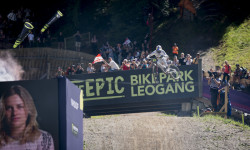
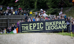
| The EPIC Bikepark Leogang | bike park | Leogang | |
| Bike-Circus - Saalbach Hinterglemm | bike park | Saalbach Hinterglemm | |
| Bike Republic Sölden | bike park | Sölden |
Upcoming Local Events
Activity Type Stats
| activitytype | trails | distance | descent | descent distance | total vertical | rating | global rank | state rank | photos | reports | routes | ridelogs |
|---|---|---|---|---|---|---|---|---|---|---|---|---|
| Mountain Bike | 1,601 | 2,434 miles | 708,960 ft | 1,186 miles | 8,780 ft | #18 | 7,953 | 19,454 | 197 | 314,425 | ||
| E-Bike | 1,238 | 2,038 miles | 536,499 ft | 970 miles | 8,681 ft | #18 | 51 | 17,731 | 107 | 38,625 | ||
| Gravel Bike | 147 | 485 miles | 42,185 ft | 188 miles | 7,523 ft | #15 | 694 | 57 | 2,922 | |||
| Adaptive Bike | 372 | 1,150 miles | 101,798 ft | 361 miles | 8,501 ft | #13 | 2,699 | 4 | 7 | |||
| Winter Fat Bike | 327 | 831 miles | 114,961 ft | 335 miles | 8,599 ft | #12 | 2,554 | |||||
| Horse | 62 | 313 miles | 14,239 ft | 134 miles | 6,250 ft | #15 | 1,727 | 17 | ||||
| Hike | 1,474 | 2,335 miles | 753,182 ft | 1,097 miles | 9,902 ft | #18 | 6 | 16,310 | 37 | 47,444 | ||
| Trail Running | 1,462 | 2,311 miles | 747,375 ft | 1,089 miles | 9,902 ft | #18 | 16,290 | 37 | 4,372 | |||
| Dirtbike/Moto | 8 | 261 miles | 4,724 ft | 114 miles | 6,148 ft | #13 | 1,641 | 4 | ||||
| Observed Trials | 7 | 12 miles | 2,464 ft | 2 miles | 4,619 ft | #11 | 20 | 7 | ||||
| ATV/ORV/OHV | 5 | 18 miles | 1,893 ft | 3 miles | 4,646 ft | #14 | 1,639 | 14 | ||||
| Snowmobile | 20 | 285 miles | 9,078 ft | 121 miles | 6,250 ft | #11 | 52 | 1 | ||||
| Snowshoe | 37 | 321 miles | 12,841 ft | 129 miles | 8,278 ft | #3 | 118 | 413 | ||||
| Downhill Ski | 850 | 862 miles | 593,560 ft | 653 miles | 10,167 ft | #5 | 8 | 87 | 55,196 | |||
| Backcountry Ski | 466 | 1,121 miles | 260,781 ft | 374 miles | 10,830 ft | #2 | 109 | 18,424 | ||||
| Nordic Ski | 34 | 307 miles | 11,946 ft | 129 miles | 6,250 ft | #3 | 105 | 10,636 |
Activities
- Austria Mountain Biking Trails
- Austria E-Biking Trails
- Austria Gravel Biking Trails
- Austria Adaptive Biking Trails
- Austria Winter Fat Biking Trails
- Austria Horseback Trails
- Austria Hiking Trails
- Austria Trail Running Trails
- Austria Dirtbiking Trails
- Austria Observed Trials Trails
- Austria ATVing/Offroading Trails
- Austria Snowmobiling Trails
- Austria Snowshoeing Trails
- Austria Skiing Trails
- Austria Backcountry Skiing Trails
- Austria Nordic Skiing Trails
Trails
Points of Interest
- Cablecar Drop-Off (Zentrum Shuttle) Other
- Cableway Drop-Off (Fendels-Ried-Bahn) Other
- Chairlift Drop-Off (Burgstallofenbahn) Other
- Chairlift Pick-Up (Burgstallofenbahn) Other
- Cableway Drop-Off (Galzigbahn) Other
- Cableway Pick-Up (Galzigbahn) Other
- Cableway Pick-Up (Rosenalmbahn) Other
- Middle station Rosenalmbahn Other
- T-Bar Pick-Up (Schlepplift Hohe Wand Wiese) Other
- T-Bar Drop-Off (Schlepplift Hohe Wand Wiese) Other
- Hofmannspitze (3,667 m)
- Teufelshorn (3,651 m)
- Kleinglockner (3,573 m)
- By canadaka
 Trailforks & contributors
 - Admins: ktm-boy-69, mpecsi, lines, larry81541
- #3174 - 91,852 views
- austria activity log | embed map of Austria mountain bike trails | austria mountain biking points of interest polygons
Downloading of trail gps tracks in kml & gpx formats is enabled for Austria.
You must login to download files.