close
-
Layers w
- Weather Layers
- Pro
- Pro
- Pro
- Pro
- Pro
- Pro
- More Layers
- Pro
- Pro
- Pro
- Pro
-
Upgrade to

3D
Trail Conditions
- Unknown
- Snow Groomed
- Snow Packed
- Snow Covered
- Snow Cover Partial
- Freeze/thaw Cycle
- Icy
- Prevalent Mud
- Wet
- Variable
- Ideal
- Dry
- Very Dry
Trail Flow (Ridden Direction)
Trailforks scans users ridelogs to determine the most popular direction each trail is ridden. A good flowing trail network will have most trails flowing in a single direction according to their intension.
The colour categories are based on what percentage of riders are riding a trail in its intended direction.
The colour categories are based on what percentage of riders are riding a trail in its intended direction.
- > 96%
- > 90%
- > 80%
- > 70%
- > 50%
- < 50%
- bi-directional trail
- no data
Trail Last Ridden
Trailforks scans ridelogs to determine the last time a trail was ridden.
- < 2 days
- < 1 week
- < 2 weeks
- < 1 month
- < 6 months
- > 6 months
Trail Ridden Direction
The intended direction a trail should be ridden.
- Downhill Only
- Downhill Primary
- Both Directions
- Uphill Primary
- Uphill Only
- One Direction
Contribute Details
Colors indicate trail is missing specified detail.
- Description
- Photos
- Description & Photos
- Videos
Trail Popularity ?
Trailforks scans ridelogs to determine which trails are ridden the most in the last 9 months.
Trails are compared with nearby trails in the same city region with a possible 25 colour shades.
Think of this as a heatmap, more rides = more kinetic energy = warmer colors.
- most popular
- popular
- less popular
- not popular
ATV/ORV/OHV Filter
Max Vehicle Width
inches
US Cell Coverage
Legend

Radar Time
Activity Recordings
Trailforks uses anonymized public activity data.
?
Activity Recordings
Trailforks uses anonymized public activity data.
?
Personal Heatmap
▶
Activity Types
all
/
none
▶
Options
2
Date range
month
–
Winter Trails
Warning
A routing network for winter maps does not exist. Selecting trails using the winter trails layer has been disabled.
Missing Trails
Most Popular
Least Popular
Trails are colored based on popularity. The more popular a trail is, the more red. Less popular trails trend towards green.
Jump Magnitude Heatmap
Heatmap of where riders jump on trails. Zoom in to see individual jumps, click circles to view jump details.
BC Backroad Status
![map legend]()
Service Road Atlas is a free to use, community-driven service for viewing and creating reports on the numerous back-country service roads around B.C. and Alberta.

Slope Aspect
Direction the slope faces
Trails Deemphasized
Trails are shown in grey.
Only show trails with no bike usage.
Suggested Layers
Based on selected activity type
Save the current map location and zoom level as your default home location whenever this page is loaded.
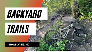
SaveBYT is Charlotte’s definitive example of primitive, technical, urban trail, weaving its way through the remnants of a 100 year old water treatment plant and using the remaining earthworks and manmade structures to create a unique riding experience. BYT is a down and dirty trail system, built to be rugged, challenging, and creative. Consisting of several segments, all trail can be linked together via the Little Sugar Creek Greenway, including the nearby Park Road Park trails.
Front Third: AKA “Farmbrook Loop” or “Skinnies Loop,” the Front Third is BYT’s least challenging area (not easy, just easier). The trailhead is located on Farmbrook Dr, east of Tyvola Rd. Go left upon entering the Farmbrook Trailhead and be treated to a self-contained loop which returns to the trailhead.
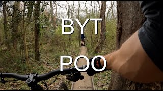
Middle Third: Middle Third encompasses the majority of the BYT trail system, and can be access from a Little Sugar Creek Greenway, or by going right at the Farmbrook trailhead. This portion of trail includes many notable areas such as the Poo Tracks (narrow concrete railways from an early 1900’s water treatment plant), miles of awesome primitive singletrack, and multiple session-able jump lines.
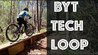
Back Third: AKA “Tech Loop,” BYT’s most technically challenging section. This trail segment can be accessed via a trailhead along Little Sugar Creek Greenway, and features several miles of intentionally challenging terrain, littered with lots of natural rock, and full of punchy climbs and technical maneuvers.
Marion Diehl: On the opposite side of Tyvola Rd from the bulk of BYT, located in the wooded areas surrounding the Marion Diehl Recreation Center and the Queens College Athletic Fields. This trail segment can be accessed via Little Sugar Creek Greenway. Use the greenway to pass underneath Tyvola Rd, then follow the trail which parallels Tyvola Rd for a short distance until the loop begins. MD has several miles of trail with ample elevation change, which translates into lots of climbing. By far the most primitive, and steepest terrain available at BYT.
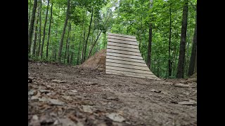
Jump Lines: BYT has three notable jump line areas, all of which are separate, session-able loops accessible via the main trail throughout Middle Third.
Original Jump Line Area: AKA “Old Jump Line” this segment houses multiple lines feeding into a single return climb. This area has a vast array of terrain, most of which is rollable, however some lines have mandatory gaps. Tabletops in this area vary in size from 12ft to 24ft. Gaps range from 12ft to 22ft. This area is home to some natural rock features, as well as several notable jumps such as “Creek Gap” and “Pipe Dream.” This area has terrain suitable for beginners, but also houses the largest and most daring features on the property. Look before you leap, and make sure you know what lies ahead.
Mini Loop: A series of rollers, berms, and jumps built into the rolling topography of former water treatment plant earthworks. Along the loop there are three main jumps: a tabletop and two low-consequence gap jumps, approx 15 ft each. These jumps are for fairly experienced riders, but have a little forgiveness built in for those who are learning. 100% rollable bypasses to all features.
Dirt Jumps: Contains two BMX-style rhythm sections, one rollable tabletop line, and the other entirely mandatory gaps. Jumps in both lines are spaced in quick succession throughout the line so the rider can pump from one jump to the next, building speed and momentum without having to pedal. Lips and landers are steeper, requiring more body english, pumping, and nosing than other jumps at BYT. The tabletop line is suitable for beginners, the gap line is for more experienced dirt jumpers.
Front Third: AKA “Farmbrook Loop” or “Skinnies Loop,” the Front Third is BYT’s least challenging area (not easy, just easier). The trailhead is located on Farmbrook Dr, east of Tyvola Rd. Go left upon entering the Farmbrook Trailhead and be treated to a self-contained loop which returns to the trailhead.
Middle Third: Middle Third encompasses the majority of the BYT trail system, and can be access from a Little Sugar Creek Greenway, or by going right at the Farmbrook trailhead. This portion of trail includes many notable areas such as the Poo Tracks (narrow concrete railways from an early 1900’s water treatment plant), miles of awesome primitive singletrack, and multiple session-able jump lines.
Back Third: AKA “Tech Loop,” BYT’s most technically challenging section. This trail segment can be accessed via a trailhead along Little Sugar Creek Greenway, and features several miles of intentionally challenging terrain, littered with lots of natural rock, and full of punchy climbs and technical maneuvers.
Marion Diehl: On the opposite side of Tyvola Rd from the bulk of BYT, located in the wooded areas surrounding the Marion Diehl Recreation Center and the Queens College Athletic Fields. This trail segment can be accessed via Little Sugar Creek Greenway. Use the greenway to pass underneath Tyvola Rd, then follow the trail which parallels Tyvola Rd for a short distance until the loop begins. MD has several miles of trail with ample elevation change, which translates into lots of climbing. By far the most primitive, and steepest terrain available at BYT.
Jump Lines: BYT has three notable jump line areas, all of which are separate, session-able loops accessible via the main trail throughout Middle Third.
Original Jump Line Area: AKA “Old Jump Line” this segment houses multiple lines feeding into a single return climb. This area has a vast array of terrain, most of which is rollable, however some lines have mandatory gaps. Tabletops in this area vary in size from 12ft to 24ft. Gaps range from 12ft to 22ft. This area is home to some natural rock features, as well as several notable jumps such as “Creek Gap” and “Pipe Dream.” This area has terrain suitable for beginners, but also houses the largest and most daring features on the property. Look before you leap, and make sure you know what lies ahead.
Mini Loop: A series of rollers, berms, and jumps built into the rolling topography of former water treatment plant earthworks. Along the loop there are three main jumps: a tabletop and two low-consequence gap jumps, approx 15 ft each. These jumps are for fairly experienced riders, but have a little forgiveness built in for those who are learning. 100% rollable bypasses to all features.
Dirt Jumps: Contains two BMX-style rhythm sections, one rollable tabletop line, and the other entirely mandatory gaps. Jumps in both lines are spaced in quick succession throughout the line so the rider can pump from one jump to the next, building speed and momentum without having to pedal. Lips and landers are steeper, requiring more body english, pumping, and nosing than other jumps at BYT. The tabletop line is suitable for beginners, the gap line is for more experienced dirt jumpers.
source: ...
 google parking directions
 Activities Click to view
- Mountain Bike
24 trails
- E-Bike
13 trails
- Hike
20 trails
- Trail Running
20 trails
Region Details
- 4
- 2
- 7
- 8
- 3
Region Status
Open as of Aug 4, 2025Stats
- Avg Trail Rating
- Trails (view details)
- 24
- Trails Mountain Bike
- 27
- Trails E-Bike
- 13
- Trails Hike
- 20
- Trails Trail Running
- 20
- Total Distance
- 11 miles
- Total Descent
- 1,171 ft
- Total Vertical
- 108 ft
- Highest Trailhead
- 688 ft
- Reports
- 214
- Photos
- 53
- Ridden Counter
- 1,115
Popular Backyard Trails Mountain Biking Trails
• 90 ★ 4.7 • 5 miles • 384 ft • 567 •
Highly rated popular black diamond difficulty singletrack. This multi-use trail can be used one direction and has a moderate overall physical rating with a 384 ft blue climb. On average it takes 15 minutes to complete this trail.
• 85 ★ 4.0 • 1,552 ft • 25 ft • 451 •
Popular blue difficulty singletrack. This multi-use trail can be used one direction. On average it takes 1 minutes to complete this trail.
• 85 ★ 4.4 • 2 miles • 103 ft • 391 •
Popular blue difficulty singletrack. This multi-use trail can be used one direction. It features berm, bridge, jump and gap jump. On average it takes 16 minutes to complete this trail.
• 55 ★ 0.0 • 180 ft • 0 ft • 274 •
Moderately popular blue difficulty singletrack. This mountain bike primary trail and has a easy overall physical rating with a 0 ft green climb. On average it takes minutes to complete this trail.
Backyard Trails Mountain Bike Routes
★ 2.0 • 8 miles • 565 ft • 5 • Loop •
Good route - just under one hour. Start with some climbing on Marion Diehl, recover on , then some fun...
Photos of Backyard Trails Mountain Bike
Videos of Backyard Trails Mountain Bike
trail: Tech Loop
2:58 |
225 |
Apr 18, 2024 , Charlotte
trail: Backyard Trails
6:55 |
572 |
Mar 7, 2023 , Charlotte
trail: Tech Loop
0:49 |
488 |
Jun 10, 2022 , Charlotte
trail: Tech Loop
14:09 |
883 |
Dec 9, 2021 , Charlotte
Recent Trail Reports
| status | trail | date | condition | info | user |
|---|---|---|---|---|---|
| Tech Loop | Aug 4, 2025 @ 4:14pm Aug 4, 2025 | Ideal | dwendover | ||
| Tyvola Parking Lot to Little Sugar Creek Greenway Connector | Mar 29, 2025 @ 1:22pm Mar 29, 2025 | Dry | dwendover | ||
| Farmbrook | Mar 13, 2025 @ 2:02pm Mar 13, 2025 | Ideal | dwendover | ||
| Farm Brook & Playstation Connector | Mar 1, 2025 @ 12:17pm Mar 1, 2025 | Ideal | dwendover | ||
| Nintendo | Feb 23, 2025 @ 2:04pm Feb 23, 2025 | Ideal | dwendover | ||
| Backyard Trails | Dec 26, 2024 @ 12:16pm Dec 26, 2024 | Dry | Somethingnew71 | ||
| Mini Loop | Nov 25, 2024 @ 2:53pm Nov 25, 2024 | Ideal | Somethingnew71 | ||
| Tanbark Place (Little Sugar Creek Greenway Connector) | Nov 16, 2024 @ 3:51pm Nov 16, 2024 | Ideal | dwendover | ||
| Poo Tracks Bypass | Jul 6, 2024 @ 3:14am Jul 6, 2024 | Ideal | Somethingnew71 |
Activity Feed
| username | action | type | title | date |
|---|---|---|---|---|
| curtisstorm | add | trail | activity #95453188 and 2 more | May 24, 2026 @ 4:11pm May 24, 2026 |
| curtisstorm | update | trail | activity #95377884 | May 23, 2026 @ 9:08pm May 23, 2026 |
| curtisstorm | update | trail | activity #95361902 | May 23, 2026 @ 3:54pm May 23, 2026 |
| curtisstorm | add | trail | activity #95345369 | May 23, 2026 @ 12:32pm May 23, 2026 |
| curtisstorm | add | trail | activity #95325894 | May 23, 2026 @ 9:16am May 23, 2026 |
Recent Comments
| username | type | title | comment | date |
|---|---|---|---|---|
| trail | Downed tree | Jun 19, 2025 @ 2:50pm Jun 19, 2025 | ||
| trail | Bring a bike with good tires and your tech... | Nov 27, 2024 @ 8:36pm Nov 27, 2024 | ||
| trail | See dad dad see ER see ER e eta r get rr | Sep 3, 2022 @ 8:03am Sep 3, 2022 |
Nearby Areas
| name | distance | ||||
|---|---|---|---|---|---|
| Marion Diehl Park | 1 | 0.1 km | |||
| Park Road Park | 2 | 2 | 0.5 km | ||
| Renaissance Park | 2 | 1 | 3.3 km | ||
| Briar Creek Greenway | 4.7 km | ||||
| Southwest District Park | 3 | 4 | 5.2 km |
Activity Type Stats
| activitytype | trails | distance | descent | descent distance | total vertical | rating | global rank | state rank | photos | reports | routes | ridelogs |
|---|---|---|---|---|---|---|---|---|---|---|---|---|
| Mountain Bike | 24 | 11 miles | 1,171 ft | 4 miles | 108 ft | #3,889 | #1,356 | 57 | 230 | 1 | 3,658 | |
| E-Bike | 13 | #8,745 | #2,789 | 2 | 211 | 112 | ||||||
| Hike | 20 | 11 miles | 1,171 ft | 4 miles | 108 ft | #11,941 | #4,876 | 230 | 45 | |||
| Trail Running | 20 | 11 miles | 1,171 ft | 4 miles | 108 ft | #10,536 | #3,947 | 230 | 177 |
Frequently Asked Questions About Backyard Trails
▼
What are the highest rated mountain biking trails in Backyard Trails?
The highest rated mountain biking trails in Backyard Trails are:
- Backyard Trails (4.3/5)
- Farmbrook (4.1/5)
- Tech Loop (4/5)
- Mini Loop (4/5)
- Nintendo (4/5)
▼
Where can I park to ride in Backyard Trails?
There are 1 parking locations listed in Backyard Trails. The most popular parking spots are:
▼
What is the longest trail in Backyard Trails?
The longest trail in Backyard Trails is Backyard Trails at 4.9 miles. View all trails sorted by distance.
▼
What are the best & highest rated hiking trails in Backyard Trails?
The best hiking trails in Backyard Trails are: View all hiking trails sorted by popularity score.
Activities
Trails
Points of Interest
- By WillieJacobsz
 Trailforks SBP SWW & contributors
 - Admins: THTB, THTB
- #68679 - 1,330 views
- backyard trails activity log | embed map of Backyard Trails mountain bike trails | backyard trails mountain biking points of interest
Downloading of trail gps tracks in kml & gpx formats is enabled for Backyard Trails.
You must login to download files.