close
-
Layers w
- Weather Layers
- Pro
- Pro
- Pro
- Pro
- Pro
- Pro
- More Layers
- Pro
- Pro
- Pro
- Pro
-
Upgrade to

3D
Trail Conditions
- Unknown
- Snow Groomed
- Snow Packed
- Snow Covered
- Snow Cover Partial
- Freeze/thaw Cycle
- Icy
- Prevalent Mud
- Wet
- Variable
- Ideal
- Dry
- Very Dry
Trail Flow (Ridden Direction)
Trailforks scans users ridelogs to determine the most popular direction each trail is ridden. A good flowing trail network will have most trails flowing in a single direction according to their intension.
The colour categories are based on what percentage of riders are riding a trail in its intended direction.
The colour categories are based on what percentage of riders are riding a trail in its intended direction.
- > 96%
- > 90%
- > 80%
- > 70%
- > 50%
- < 50%
- bi-directional trail
- no data
Trail Last Ridden
Trailforks scans ridelogs to determine the last time a trail was ridden.
- < 2 days
- < 1 week
- < 2 weeks
- < 1 month
- < 6 months
- > 6 months
Trail Ridden Direction
The intended direction a trail should be ridden.
- Downhill Only
- Downhill Primary
- Both Directions
- Uphill Primary
- Uphill Only
- One Direction
Contribute Details
Colors indicate trail is missing specified detail.
- Description
- Photos
- Description & Photos
- Videos
Trail Popularity ?
Trailforks scans ridelogs to determine which trails are ridden the most in the last 9 months.
Trails are compared with nearby trails in the same city region with a possible 25 colour shades.
Think of this as a heatmap, more rides = more kinetic energy = warmer colors.
- most popular
- popular
- less popular
- not popular
ATV/ORV/OHV Filter
Max Vehicle Width
inches
US Cell Coverage
Legend

Radar Time
Activity Recordings
Trailforks uses anonymized public activity data.
?
Activity Recordings
Trailforks uses anonymized public activity data.
?
Personal Heatmap
▶
Activity Types
all
/
none
▶
Options
2
Date range
month
–
Winter Trails
Warning
A routing network for winter maps does not exist. Selecting trails using the winter trails layer has been disabled.
Missing Trails
Most Popular
Least Popular
Trails are colored based on popularity. The more popular a trail is, the more red. Less popular trails trend towards green.
Jump Magnitude Heatmap
Heatmap of where riders jump on trails. Zoom in to see individual jumps, click circles to view jump details.
BC Backroad Status
![map legend]()
Service Road Atlas is a free to use, community-driven service for viewing and creating reports on the numerous back-country service roads around B.C. and Alberta.

Slope Aspect
Direction the slope faces
Trails Deemphasized
Trails are shown in grey.
Only show trails with no bike usage.
Suggested Layers
Based on selected activity type
Save the current map location and zoom level as your default home location whenever this page is loaded.
Save
No description for Baia Mare has been added yet!
Login or register to submit one.
This region uses the Uk/Euro style trail grading system.
Activities Click to view
- Mountain Bike
91 trails
- E-Bike
63 trails
- Adaptive Bike
0 trails
- Winter Fat Bike
0 trails
- Horse
16 trails
- Hike
88 trails
- Trail Running
73 trails
Region Details
- 30
- 8
- 28
- 16
- 9
Region Status
Open as of 11 hoursStats
- Avg Trail Rating
- Trails (view details)
- 91
- Trails Mountain Bike
- 91
- Trails E-Bike
- 63
- Trails Horse
- 16
- Trails Hike
- 88
- Trails Trail Running
- 73
- Trails Dirtbike/Moto
- 2
- Total Distance
- 104 miles
- Total Descent Distance
- 56 miles
- Total Descent
- 36,988 ft
- Total Vertical
- 3,492 ft
- Highest Trailhead
- 4,256 ft
- Reports
- 2,188
- Photos
- 134
- Ridden Counter
- 966
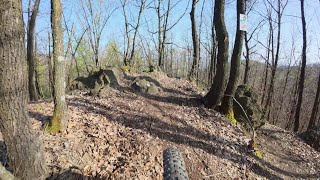
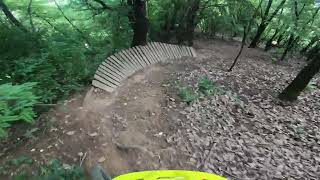
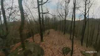
Popular Baia Mare Mountain Biking Trails
• 90 ★ 4.5 • 4,478 ft • 0 ft • 33 •
It's not a true of course but it's one of the closest mountain bike oriented single trails we have. It is maintained by a few persons who designed it, built certain elements and kickers and the community as a whole who keep it clean....
• 95 ★ 4.7 • 4,715 ft • 9 ft • 24 •
Highly rated popular blue difficulty singletrack. This mountain bike primary trail can be used downhill primary and has a moderate overall physical rating. It features rock garden. Trail visibility is always easy to follow. On average it takes 6 minutes to complete this trail.
• 90 ★ 4.0 • 2,241 ft • 163 ft • 23 •
Link Valea Usturoiu - Vf Feriga sectiune de legatura
• 85 ★ 4.8 • 1 mile • 94 ft • 21 •
Popular red difficulty singletrack. This mountain bike primary trail can be used downhill only and has a moderate overall physical rating. It features drop and rock garden. On average it takes 9 minutes to complete this trail.
• 100 ★ 5.0 • 1,768 ft • 147 ft • 20 •
Link Drum Forestier Vicleanul Mare -> Cariera Low Fierastraului
• 60 ★ 2.7 • 4 miles • 140 ft • 20 •
Moderately popular blue difficulty singletrack. This mountain bike primary trail can be used downhill primary and has a moderate overall physical rating. Adaptive MTB rating: amtb green. Trail visibility is sometimes hard to follow. On average it takes 24 minutes to complete this trail.
• 90 ★ 4.4 • 1 mile • 234 ft • 18 •
Popular blue difficulty singletrack. This mountain bike primary trail can be used both directions. On average it takes 6 minutes to complete this trail.
Baia Mare Mountain Bike Routes
★ 1.0 • 3 miles • 827 ft • 1 •
MM Circuit Uzina - Lacul Bodi Ferneziu spre marcare
5 miles • 1,926 ft • 1 •
Traseu MTB Statuia Ostasului - Varful Feriga propus pentru omologare
5 miles • 1,967 ft • 1 •
Traseu MTB Statuia Ostasului - Refugiu Plestioara - traseu spre omologare
4 miles • 881 ft • 1 •
MM traseu Dakar , Statuiue - - traseu spre marcare
10 miles • 2,781 ft • 2 •
MM Statuia Ostasului Roman - Panou Ulmoasa spre marcare
8 miles • 2,654 ft • 1 •
MM Traseu Turistic Triunghi Albastru traseu omologat
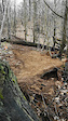
Photos of Baia Mare Mountain Bike
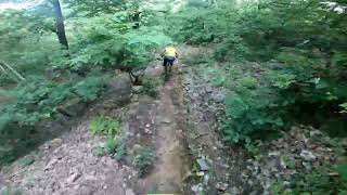
Videos of Baia Mare Mountain Bike
trail: Espresso
0:16 |
118 |
Apr 16, 2022
trail: Lespezi
12:11 |
72 |
Aug 19, 2025 , Baia Mare
trail: Espresso
2:01 |
121 |
Jun 4, 2025 , Baia Mare
trail: Paris
0:57 |
72 |
Jun 3, 2025 , Baia Mare
trail: Vf Elena -> Magura Trail
3:15 |
72 |
Jun 2, 2025 , Baia Mare
trail: Espresso
2:15 |
118 |
Jan 28, 2025 , Baia Mare
trail: Vf Elena -> Magura Trail
3:26 |
117 |
Dec 22, 2024 , Baia Mare
trail: Ciobăneasca
0:25 |
142 |
Jun 16, 2024 , Baia Mare
Recent Trail Reports
| status | trail | date | condition | info | user |
|---|---|---|---|---|---|
| Mothership | Jun 21, 2026 @ 12:42pm (Europe/Bucharest) 11 hours | Ideal | pauldespre | ||
| Route 66 | Jun 21, 2026 @ 12:42pm (Europe/Bucharest) 11 hours | Ideal | pauldespre | ||
| Valea Usturoiu | Jun 21, 2026 @ 12:42pm (Europe/Bucharest) 11 hours | Ideal | pauldespre | ||
| Espresso | Jun 21, 2026 @ 12:42pm (Europe/Bucharest) 11 hours | Dry | pauldespre | ||
| acces 16 febr / espresso / downhill cariera | Jun 21, 2026 @ 12:42pm (Europe/Bucharest) 11 hours | Ideal | pauldespre | ||
| Link Drum Forestier Vicleanul Mare -> Cariera Low Fierastraului | Jun 21, 2026 @ 12:42pm (Europe/Bucharest) 11 hours | Ideal | pauldespre | ||
| Paralel uzina | Jun 21, 2026 @ 12:42pm (Europe/Bucharest) 11 hours | Ideal | pauldespre | ||
| Paris | Jun 3, 2026 @ 7:02pm (Europe/Budapest) Jun 3, 2026 | Wet | andreizr1 | ||
| Piatra Virgină - Dakar V1 | Jun 3, 2026 @ 7:02pm (Europe/Budapest) Jun 3, 2026 | Ideal | andreizr1 | ||
| Grebla - Inferior | Jun 3, 2026 @ 7:02pm (Europe/Budapest) Jun 3, 2026 | Wet | andreizr1 |
Activity Feed
| username | action | type | title | date |
|---|---|---|---|---|
| pauldespre | add | report | activity #97482150 and 6 more | Jun 21, 2026 @ 7:23am 6 hours |
| pauldespre | add | report | activity #97256661 and 2 more | Jun 18, 2026 @ 9:12am Jun 18, 2026 |
| Nonchalantul | vote | route | activity #96470534 | Jun 7, 2026 @ 9:30am Jun 7, 2026 |
| andreizr1 | add | report | activity #96209828 and 6 more | Jun 4, 2026 @ 12:43am Jun 4, 2026 |
| belusianubBXRXD | checkin | trail | activity #95852954 | May 30, 2026 @ 8:05am May 30, 2026 |
Recent Comments
| username | type | title | comment | date |
|---|---|---|---|---|
| report | Ăsta nu-i traseu de bicicletă | Jun 8, 2024 @ 9:48am Jun 8, 2024 | ||
| trail | Daca ciobaneasca nu e black. Nici cariera nu e. | Oct 10, 2023 @ 11:23am Oct 10, 2023 | ||
| trail | Curatat cap-coada la inceput de septembrie... | Sep 11, 2022 @ 12:25pm Sep 11, 2022 | ||
| trail | Aș zice că mai degrabă e albastru ca... | Jul 10, 2021 @ 10:36am Jul 10, 2021 | ||
| trail | doar pe alocuri , trebuie sa vi o tura | Mar 5, 2021 @ 12:45am Mar 5, 2021 |
Local Badges
-

10 Blue Trails13 awarded -

Epic Mountain Bike Climb 2k90 awarded -

Climbing 10k Badge13 awarded -

Mountain Biking 100k Badge6 awarded -

Epic Ride Descent 2k90 awarded -

Descent 10k Badge13 awarded
Local Mountain Biking Directory
-
The Golden Trails
![The Golden Trails]()
-
Bikeshop Baia MareBike Shop
-
Magazin Extrem Bike-sportBike Shop
-
BikeshopbmBike Shop
Activity Type Stats
| activitytype | trails | distance | descent | descent distance | total vertical | rating | global rank | state rank | photos | reports | routes | ridelogs |
|---|---|---|---|---|---|---|---|---|---|---|---|---|
| Mountain Bike | 91 | 104 miles | 36,988 ft | 56 miles | 3,491 ft | #931 | #2 | 134 | 2,188 | 7 | 4,576 | |
| E-Bike | 63 | 74 miles | 25,240 ft | 40 miles | 2,005 ft | #809 | #20 | 2,157 | 769 | |||
| Horse | 16 | 5 miles | 2,001 ft | 2 miles | 1,132 ft | #521 | #14 | 5 | ||||
| Hike | 88 | 93 miles | 33,944 ft | 50 miles | 3,491 ft | #1,098 | #6 | 2,185 | 5 | 207 | ||
| Trail Running | 73 | 90 miles | 31,949 ft | 48 miles | 3,491 ft | #842 | #22 | 2,184 | 4 | 123 | ||
| Dirtbike/Moto | 2 | 3,494 ft | 243 ft | 1,850 ft | 367 ft | 3 |
Frequently Asked Questions About Baia Mare
▼
What are the highest rated mountain biking trails in Baia Mare?
The highest rated mountain biking trails in Baia Mare are:
- Espresso (4.4/5)
- Feriga trail 1 (4.4/5)
- Trail Bulat V3 Vodka (4.3/5)
- Downhill 16 februarie (4.3/5)
- "Bike Park" (4.2/5)
▼
What is the best time of the year to ride in Baia Mare?
Based on ride log data, the most popular months to ride in Baia Mare are:
- May (76 activities)
- April (51 activities)
- June (50 activities)
▼
Where can I park to ride in Baia Mare?
Check the Baia Mare trail map for trailhead and parking information. Community members regularly update access and parking details for trails in the area.
▼
What is the longest trail in Baia Mare?
The longest trail in Baia Mare is Route 66 at 4.1 miles. View all trails sorted by distance.
Activities
Trails
Points of Interest
- By andreizr1 & contributors
- Admins: pufalot
- #33525 - 9,137 views
- baia mare activity log | embed map of Baia Mare mountain bike trails |
Downloading of trail gps tracks in kml & gpx formats is enabled for Baia Mare.
You must login to download files.