close
-
Layers w
- Weather Layers
- Pro
- Pro
- Pro
- Pro
- Pro
- Pro
- More Layers
- Pro
- Pro
- Pro
- Pro
-
Upgrade to

3D
Trail Conditions
- Unknown
- Snow Groomed
- Snow Packed
- Snow Covered
- Snow Cover Partial
- Freeze/thaw Cycle
- Icy
- Prevalent Mud
- Wet
- Variable
- Ideal
- Dry
- Very Dry
Trail Flow (Ridden Direction)
Trailforks scans users ridelogs to determine the most popular direction each trail is ridden. A good flowing trail network will have most trails flowing in a single direction according to their intension.
The colour categories are based on what percentage of riders are riding a trail in its intended direction.
The colour categories are based on what percentage of riders are riding a trail in its intended direction.
- > 96%
- > 90%
- > 80%
- > 70%
- > 50%
- < 50%
- bi-directional trail
- no data
Trail Last Ridden
Trailforks scans ridelogs to determine the last time a trail was ridden.
- < 2 days
- < 1 week
- < 2 weeks
- < 1 month
- < 6 months
- > 6 months
Trail Ridden Direction
The intended direction a trail should be ridden.
- Downhill Only
- Downhill Primary
- Both Directions
- Uphill Primary
- Uphill Only
- One Direction
Contribute Details
Colors indicate trail is missing specified detail.
- Description
- Photos
- Description & Photos
- Videos
Trail Popularity ?
Trailforks scans ridelogs to determine which trails are ridden the most in the last 9 months.
Trails are compared with nearby trails in the same city region with a possible 25 colour shades.
Think of this as a heatmap, more rides = more kinetic energy = warmer colors.
- most popular
- popular
- less popular
- not popular
ATV/ORV/OHV Filter
Max Vehicle Width
inches
US Cell Coverage
Legend

Radar Time
Activity Recordings
Trailforks uses anonymized public activity data.
?
Activity Recordings
Trailforks uses anonymized public activity data.
?
Personal Heatmap
▶
Activity Types
all
/
none
▶
Options
2
Date range
month
–
Winter Trails
Warning
A routing network for winter maps does not exist. Selecting trails using the winter trails layer has been disabled.
Missing Trails
Most Popular
Least Popular
Trails are colored based on popularity. The more popular a trail is, the more red. Less popular trails trend towards green.
Jump Magnitude Heatmap
Heatmap of where riders jump on trails. Zoom in to see individual jumps, click circles to view jump details.
BC Backroad Status
![map legend]()
Service Road Atlas is a free to use, community-driven service for viewing and creating reports on the numerous back-country service roads around B.C. and Alberta.

Slope Aspect
Direction the slope faces
Trails Deemphasized
Trails are shown in grey.
Only show trails with no bike usage.
Suggested Layers
Based on selected activity type
Save the current map location and zoom level as your default home location whenever this page is loaded.
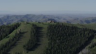
SaveMulti-use trails, Osberg Ridgeline and Oregon Gulch are motorized.
Primary Trail Type: Cross-Country
Shuttleable: YES
Land Status: National Forest
 google parking directions
Links
IMBA Ride Center

Sun Valley
Activities Click to view
- Mountain Bike
10 trails
- E-Bike
3 trails
- Horse
0 trails
- Hike
10 trails
- Trail Running
10 trails
- Dirtbike/Moto
2 trails
Region Details
- 2
- 3
- 5
Region Status
Caution as of Jun 21, 2026Local Trail Association
Stats
- Avg Trail Rating
- Trails (view details)
- 11
- Trails Mountain Bike
- 11
- Trails E-Bike
- 3
- Trails Hike
- 10
- Trails Trail Running
- 10
- Trails Dirtbike/Moto
- 2
- Trails ATV/ORV/OHV
- 1
- Total Distance
- 52 miles
- Total Descent
- 5,354 ft
- Total Vertical
- 2,960 ft
- Highest Trailhead
- 9,590 ft
- Reports
- 215
- Photos
- 191
- Ridden Counter
- 1,770
Popular Baker Mountain Biking Trails
• 80 ★ 5.0 • 5 miles • 58 ft • 452 •
This is the new reroute of the historical trail. This trail contains many natural and man made dirt and rock features. This trail makes the Osberg Trail into a loop or it can be accessed off of the East fork of Baker Creek rd. The...
• 75 ★ 4.4 • 14 miles • 2,216 ft • 436 •
The trail has a seasonal designation for motorcycle and e-bike use and is open to those uses from May 1 through August 29 of each year. Originally built by the Civilian Conservation Corps in the 1930s, and known then as the Warm Springs...
• 15 ★ 3.2 • 8 miles • 2,152 ft • 53 •
Scrappy trail with a rock-shelf near the bottom that is very hard to get up, especially for equestrians and motorcyclists. This step is encountered as an uphill move as one descends on the trail. It is very close to the bottom of the...
• 40 ★ 3.0 • 3 miles • 1,348 ft • 21 •
A less traveled trail that is especially popular with horseback riders.
• 15 ★ 0.0 • 4 miles • 1,846 ft • 20 •
The bottom 1.3 miles of this trail is used heavily as the access to the approx 1/4 mile long #818. The higher reaches of the 138 require good route finding skills. The very top of this trail is open to motorcycle and ebike use. This...
• 40 ★ 0.0 • 1,398 ft • 91 ft • 6 •
Great easier 1.5-mile long hike from to the lake. This hike combines the short #818 trail with the lowest 1.3 miles of the #138. is beautifully positioned beneath impressive, red rock spires. The casual hike to the lake makes this a...
Baker Mountain Bike Routes
★ 3.0 • 16 miles • 2,482 ft • 7 • Loop •
Makes a loop to do Alden Gulch instead of the out and back climb
Photos of Baker Mountain Bike
Videos of Baker Mountain Bike
trail: Curly's
3:34 |
2539 |
Jun 30, 2016
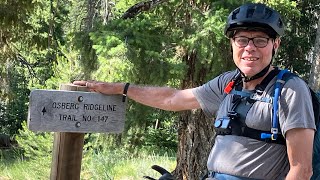
trail: Osberg Ridgeline Trail
23:12 |
102 |
Sep 8, 2025 , Ketchum
trail: Castle Rock
0:49 |
53 |
Jul 14, 2025 , Ketchum
youtuber
![Kyle Warner Said: Don't Skip This Trail |...]()

trail: Osberg Ridgeline Trail
11:59 |
418 |
Dec 6, 2021 , Ketchum
youtuber
![Kyle Warner Said: Don't Skip This Trail |...]()

trail: Alden Gulch (Re-Route)
11:59 |
410 |
Dec 6, 2021 , Ketchum

trail: Alden Gulch (Re-Route)
17:39 |
439 |
Aug 3, 2021 , Ketchum

trail: Osberg Ridgeline Trail
14:40 |
527 |
Jun 23, 2021 , Ketchum
Current Trail Warnings
| status | trail | date | condition | user | info |
|---|---|---|---|---|---|
| Castle Rock | Jun 7, 2026 @ 9:28pm (America/Boise) Jun 7, 2026 | Variable | kinsler | Dirtbike/Moto Snow free. Only cut from Placer up. |
Recent Trail Reports
| status | trail | date | condition | info | user |
|---|---|---|---|---|---|
| Curly's | Jun 21, 2026 @ 11:40pm (America/Boise) 3 days | Dry | marmotkong | ||
| Osberg Ridgeline Trail | Jun 21, 2026 @ 4:47pm (America/Boise) Jun 21, 2026 | Ideal | ccmski | ||
| Alden Gulch (Re-Route) | Jun 21, 2026 @ 4:46pm (America/Boise) Jun 21, 2026 | Dry | ccmski | ||
| Norton Cr | Jun 16, 2026 @ 2:49pm (America/Los_Angeles) Jun 16, 2026 | Snow Cover Partial | Bonking | ||
| Apollo Creek | Jun 16, 2026 @ 2:49pm (America/Los_Angeles) Jun 16, 2026 | Snow Cover Partial | Bonking | ||
| Baker Norton Connector | Jun 11, 2026 @ 6:31pm (America/Boise) Jun 11, 2026 | Variable | clarkcmac | ||
| East Fork of Baker Road | May 28, 2026 @ 8:53pm (America/Boise) May 28, 2026 | Ideal | ccmski | ||
| Baker Creek-Norton Creek | Jan 12, 2026 @ 3:27pm (America/Boise) Jan 12, 2026 | Snow Cover Partial | woodrivermiles WRTC | ||
| Baker Lake | Jul 8, 2025 @ 4:06pm Jul 8, 2025 | Very Dry | |||
| Royal Gorge-Norton Connector | Nov 18, 2024 @ 2:55pm Nov 18, 2024 | Snow Covered | woodrivermiles WRTC |
Activity Feed
| username | action | type | title | date |
|---|---|---|---|---|
| carrotroot | like | report | activity #97737860 | Jun 24, 2026 @ 6:02pm 2 hours |
| track30 | wishlist | trail | activity #97722916 | Jun 24, 2026 @ 2:02pm 6 hours |
| elund22 | wishlist | trail | activity #97674969 | Jun 23, 2026 @ 9:44pm 22 hours |
| bbinge | wishlist | trail | activity #97556803 | Jun 22, 2026 @ 6:13am 3 days |
| ccmski | add | report | activity #97526969 and 1 more | Jun 21, 2026 @ 3:46pm Jun 21, 2026 |
Recent Comments
| username | type | title | comment | date |
|---|---|---|---|---|
| trail | Trail is clear of deadfall. Some sections have... | Jun 21, 2026 @ 3:29pm Jun 21, 2026 | ||
| report | Probably a hundred trees down. Lots of small... | Jun 7, 2026 @ 8:11am Jun 7, 2026 | ||
| trail | Did Osberg to Alden on an e-bike. Great ride!... | Oct 16, 2025 @ 6:50am Oct 16, 2025 | ||
| trail | Trail was nice and dry on 9/16/25 | Sep 16, 2025 @ 4:12pm Sep 16, 2025 | ||
| report | Thank you! | Jun 3, 2025 @ 8:52am Jun 3, 2025 |
Nearby Areas
| name | distance | ||||
|---|---|---|---|---|---|
| Prairie/Miner | 4 | 4 | 4.1 km | ||
| Warmsprings | 3 | 7 | 1 | 6.4 km | |
| North of Ketchum | 7 | 1 | 8 km | ||
| Adam's Gulch | 1 | 10 | 5 | 8.5 km | |
| Smoky Mountains | 7 | 1 | 10.1 km |
Local Products
Activity Type Stats
| activitytype | trails | distance | descent | descent distance | total vertical | rating | global rank | state rank | photos | reports | routes | ridelogs |
|---|---|---|---|---|---|---|---|---|---|---|---|---|
| Mountain Bike | 10 | 52 miles | 5,253 ft | 15 miles | 2,959 ft | #5,725 | #2,105 | 203 | 207 | 1 | 1,027 | |
| E-Bike | 3 | 31 miles | 2,034 ft | 9 miles | 2,959 ft | #4,397 | #1,226 | 132 | 90 | |||
| Hike | 10 | 46 miles | 5,230 ft | 15 miles | 2,959 ft | #5,535 | #1,993 | 207 | 116 | |||
| Trail Running | 10 | 46 miles | 5,230 ft | 15 miles | 2,959 ft | #4,698 | #1,363 | 9 | 207 | 17 | ||
| Dirtbike/Moto | 2 | 7 miles | 125 ft | 1,778 ft | 2,139 ft | #1,102 | #519 | 72 | 1 | |||
| ATV/ORV/OHV | 1 | 6 miles | 23 ft | 771 ft | 991 ft | 34 |
Frequently Asked Questions About Baker
▼
What are the highest rated mountain biking trails in Baker?
The highest rated mountain biking trails in Baker are:
- Alden Gulch (Re-Route) (4.6/5)
- Osberg Ridgeline Trail (4.3/5)
- Curly's (4.2/5)
- Apollo Creek (3.7/5)
- Castle Rock (3.6/5)
▼
What is the best time of the year to ride in Baker?
Based on ride log data, the most popular months to ride in Baker are:
- July (27 activities)
- August (21 activities)
- June (12 activities)
▼
Where can I park to ride in Baker?
There are 1 parking locations listed in Baker. The most popular parking spots are:
▼
What is the longest trail in Baker?
The longest trail in Baker is Osberg Ridgeline Trail at 21.9 km. View all trails sorted by distance.
- By woodrivermiles
 WRTC & contributors
 - Admins: WRTC, BCRD, WRTC
- #14100 - 3,625 views
- baker activity log | embed map of Baker mountain bike trails | baker mountain biking points of interest
Downloading of trail gps tracks in kml & gpx formats is enabled for Baker.
You must login to download files.