close
-
Layers w
- Weather Layers
- Pro
- Pro
- Pro
- Pro
- Pro
- Pro
- More Layers
- Pro
- Pro
- Pro
- Pro
-
Upgrade to

3D
Trail Conditions
- Unknown
- Snow Groomed
- Snow Packed
- Snow Covered
- Snow Cover Partial
- Freeze/thaw Cycle
- Icy
- Prevalent Mud
- Wet
- Variable
- Ideal
- Dry
- Very Dry
Trail Flow (Ridden Direction)
Trailforks scans users ridelogs to determine the most popular direction each trail is ridden. A good flowing trail network will have most trails flowing in a single direction according to their intension.
The colour categories are based on what percentage of riders are riding a trail in its intended direction.
The colour categories are based on what percentage of riders are riding a trail in its intended direction.
- > 96%
- > 90%
- > 80%
- > 70%
- > 50%
- < 50%
- bi-directional trail
- no data
Trail Last Ridden
Trailforks scans ridelogs to determine the last time a trail was ridden.
- < 2 days
- < 1 week
- < 2 weeks
- < 1 month
- < 6 months
- > 6 months
Trail Ridden Direction
The intended direction a trail should be ridden.
- Downhill Only
- Downhill Primary
- Both Directions
- Uphill Primary
- Uphill Only
- One Direction
Contribute Details
Colors indicate trail is missing specified detail.
- Description
- Photos
- Description & Photos
- Videos
Trail Popularity ?
Trailforks scans ridelogs to determine which trails are ridden the most in the last 9 months.
Trails are compared with nearby trails in the same city region with a possible 25 colour shades.
Think of this as a heatmap, more rides = more kinetic energy = warmer colors.
- most popular
- popular
- less popular
- not popular
ATV/ORV/OHV Filter
Max Vehicle Width
inches
US Cell Coverage
Legend

Radar Time
Activity Recordings
Trailforks uses anonymized public activity data.
?
Activity Recordings
Trailforks uses anonymized public activity data.
?
Personal Heatmap
▶
Activity Types
all
/
none
▶
Options
2
Date range
month
–
Winter Trails
Warning
A routing network for winter maps does not exist. Selecting trails using the winter trails layer has been disabled.
Missing Trails
Most Popular
Least Popular
Trails are colored based on popularity. The more popular a trail is, the more red. Less popular trails trend towards green.
Jump Magnitude Heatmap
Heatmap of where riders jump on trails. Zoom in to see individual jumps, click circles to view jump details.
BC Backroad Status
![map legend]()
Service Road Atlas is a free to use, community-driven service for viewing and creating reports on the numerous back-country service roads around B.C. and Alberta.

Slope Aspect
Direction the slope faces
Trails Deemphasized
Trails are shown in grey.
Only show trails with no bike usage.
Suggested Layers
Based on selected activity type
Save the current map location and zoom level as your default home location whenever this page is loaded.
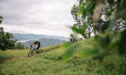
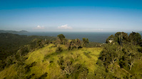
SaveBali Is one of the most popular tourist destination in Indonesia and with all the mountains it's ripe with mountain bike trails
source: Bali Bike Park
Primary Trail Type: All-Mountain & Downhill
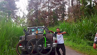
Shuttleable: YES
Land Status: National Forest
Stats
- Avg Trail Rating
- Trails (view details)
- 26
- Trails Mountain Bike
- 26
- Trails Hike
- 13
- Trails Trail Running
- 13
- Total Distance
- 52 miles
- Total Descent
- 32,805 ft
- Total Vertical
- 5,137 ft
- Highest Trailhead
- 5,163 ft
- Reports
- 9
- Photos
- 82
- Ridden Counter
- 473
Articles

Behind The Scenes of Tomomi Nishikubo’s Chaotic New Bali Edit
Nov 24, 2025 from pinkbike.com
What it really took to film trials riding inside one of Bali’s busiest party clubs.
Searching for the Elusive
Mar 14, 2018 from pinkbike.com
Jimmy Smith heads to Bali on a trip that combines his two passions: biking and surfing.
Sub Regions
- Klungkung (2)
- Singaraja (21)
- Bali Bike Park (10)
- Gunung Batur (0)
Popular Bali Mountain Biking Trails
• 100 ★ 3.0 • 2 miles • 2 ft • 42 •
Unclear if there was every a purpose built trail here, but if there was it has since disappeared into the rain ruts and overgrown jungle. Bring a machete if you intend to complete it top to bottom.
• 90 ★ 5.0 • 1,167 ft • 0 ft • 37 •
Popular green difficulty singletrack. This mountain bike primary trail can be used downhill only and has a moderate overall physical rating. It features berm, jump and other. On average it takes 1 minutes to complete this trail.
• 40 ★ 5.0 • 2,374 ft • 7 ft • 36 •
Moderately popular blue difficulty singletrack. This mountain bike primary trail can be used downhill only and has a easy overall physical rating. It features berm, jump and other. On average it takes 6 minutes to complete this trail.
• 100 ★ 0.0 • 1,109 ft • 0 ft • 35 •
Popular blue difficulty singletrack. This mountain bike primary trail can be used downhill only. On average it takes minutes to complete this trail.
• 60 ★ 5.0 • 1,510 ft • 2 ft • 34 •
Moderately popular green difficulty singletrack. This mountain bike primary trail can be used downhill only and has a moderate overall physical rating with a 2 ft green climb. It features berm, jump and other. On average it takes 3 minutes to complete this trail.
• 80 ★ 3.5 • 3,867 ft • 47 ft • 33 •
Popular blue difficulty singletrack. This mountain bike primary trail can be used downhill only. It features berm, drop, jump, gap jump, ladder bridge and other. On average it takes 5 minutes to complete this trail.
• 50 ★ 0.0 • 414 ft • 0 ft • 32 •
Moderately popular blue difficulty singletrack. This mountain bike primary trail can be used downhill only and has a moderate overall physical rating with a 0 ft green climb. It features a-frame, berm, jump and other. On average it takes minutes to complete this trail.
• 5 ★ 0.0 • 11 miles • 1,682 ft • 23 •
From the starting point the long trail winds up and down on the for about 1 - 3 hours and then drops down to the north shore for another 1 - 2 hours.
Bali Mountain Bike Routes
Photos of Bali Mountain Bike
Videos of Bali Mountain Bike
featured
![First Taste Of A Bali Bike Park Line...]()

797 |
Dec 8, 2015
0:37 |
48 |
Jul 12, 2018
trail: Hipsta
5:14 |
9218 |
Dec 29, 2016
3:53 |
24411 |
Sep 9, 2015

3:22 |
8853 |
Sep 3, 2015

4:23 |
19098 |
Aug 30, 2015

trail: Munduk Tengah Access Road
17:48 |
377 |
Dec 1, 2018 , Klungkung

trail: Munduk Tengah Enduro
12:06 |
594 |
Dec 1, 2018 , Klungkung
Recent Trail Reports
| status | trail | date | condition | info | user |
|---|---|---|---|---|---|
| Geothermal Trail 2 Singaraja | Jan 29, 2023 @ 6:23pm Jan 29, 2023 | Variable | apaguha | ||
| Geothermal Trail 1 Singaraja | Jan 30, 2023 @ 2:23am Jan 30, 2023 | Variable | apaguha | ||
| Besakih Mountain bike park - Bali (Lateng line) Bali | Jul 30, 2019 @ 7:41pm Jul 30, 2019 | Dry | bados | ||
| Hipsta Bali Bike Park | Jun 11, 2019 @ 7:32pm Jun 11, 2019 | Unknown | vandall | ||
| Berm Z-Line Bali Bike Park | Jun 11, 2019 @ 7:32pm Jun 11, 2019 | Unknown | vandall | ||
| Crater Rim Singaraja | May 2, 2018 @ 1:19am May 2, 2018 | Dry | bados | ||
| Sambirenteng Singaraja | Jun 20, 2017 @ 6:59pm Jun 20, 2017 | Variable | frei |
Activity Feed
| username | action | type | title | date |
|---|---|---|---|---|
| sixohfourx | ridden | trail | activity #96939930 | Jun 13, 2026 @ 10:48pm Jun 13, 2026 |
| sixohfourx | ridden | trail | activity #96932921 and 4 more | Jun 13, 2026 @ 6:54pm Jun 13, 2026 |
| ChrisBan21 | update | trail | activity #92843407 and 1 more | Apr 18, 2026 @ 3:34am Apr 18, 2026 |
| WHOLENESS | wishlist | region | activity #87705521 | Jan 23, 2026 @ 6:52pm Jan 23, 2026 |
| dvdrlee | add | photo | activity #85332049 and 1 more | Dec 10, 2025 @ 2:48pm Dec 10, 2025 |
Recent Comments
| username | type | title | comment | date |
|---|---|---|---|---|
| trail | August 2024: abanonded and overgrown but still... | Aug 23, 2024 @ 11:27pm Aug 23, 2024 |
Local Badges
-

Epic Ride Climb 2k10 awarded -

Climbing 10k Badge2 awarded -

Climbing 100k Badge0 awarded -

Epic Ride Descent 2k34 awarded -

Descent 10k Badge4 awarded -

Descent 100k Badge0 awarded
Bike & Skill Parks
| name | type | city | rating |
|---|---|---|---|
| Bali Bike Park | bike park | Singaraja |
Activity Type Stats
| activitytype | trails | distance | descent | descent distance | total vertical | rating | global rank | state rank | photos | reports | routes | ridelogs |
|---|---|---|---|---|---|---|---|---|---|---|---|---|
| Mountain Bike | 26 | 52 miles | 32,805 ft | 38 miles | 5,138 ft | 80 | 9 | 1 | 2,480 | |||
| Hike | 9 | 33 miles | 18,045 ft | 22 miles | 4,882 ft | 2 | 8 | 833 | ||||
| Trail Running | 13 | 33 miles | 18,045 ft | 22 miles | 4,882 ft | 8 | 1 | 29 |
Trails
- By BaliBikePark & contributors
- Admins: jack-jacobs, rifu
- #10602 - 12,174 views
- bali activity log | embed map of Bali mountain bike trails | bali mountain biking points of interest
Downloading of trail gps tracks in kml & gpx formats is enabled for Bali.
You must login to download files.