close
-
Layers w
- Weather Layers
- Pro
- Pro
- Pro
- Pro
- Pro
- Pro
- More Layers
- Pro
- Pro
- Pro
- Pro
-
Upgrade to

3D
Trail Conditions
- Unknown
- Snow Groomed
- Snow Packed
- Snow Covered
- Snow Cover Partial
- Freeze/thaw Cycle
- Icy
- Prevalent Mud
- Wet
- Variable
- Ideal
- Dry
- Very Dry
Trail Flow (Ridden Direction)
Trailforks scans users ridelogs to determine the most popular direction each trail is ridden. A good flowing trail network will have most trails flowing in a single direction according to their intension.
The colour categories are based on what percentage of riders are riding a trail in its intended direction.
The colour categories are based on what percentage of riders are riding a trail in its intended direction.
- > 96%
- > 90%
- > 80%
- > 70%
- > 50%
- < 50%
- bi-directional trail
- no data
Trail Last Ridden
Trailforks scans ridelogs to determine the last time a trail was ridden.
- < 2 days
- < 1 week
- < 2 weeks
- < 1 month
- < 6 months
- > 6 months
Trail Ridden Direction
The intended direction a trail should be ridden.
- Downhill Only
- Downhill Primary
- Both Directions
- Uphill Primary
- Uphill Only
- One Direction
Contribute Details
Colors indicate trail is missing specified detail.
- Description
- Photos
- Description & Photos
- Videos
Trail Popularity ?
Trailforks scans ridelogs to determine which trails are ridden the most in the last 9 months.
Trails are compared with nearby trails in the same city region with a possible 25 colour shades.
Think of this as a heatmap, more rides = more kinetic energy = warmer colors.
- most popular
- popular
- less popular
- not popular
ATV/ORV/OHV Filter
Max Vehicle Width
inches
US Cell Coverage
Legend

Radar Time
Activity Recordings
Trailforks uses anonymized public activity data.
?
Activity Recordings
Trailforks uses anonymized public activity data.
?
Personal Heatmap
▶
Activity Types
all
/
none
▶
Options
2
Date range
month
–
Winter Trails
Warning
A routing network for winter maps does not exist. Selecting trails using the winter trails layer has been disabled.
Missing Trails
Most Popular
Least Popular
Trails are colored based on popularity. The more popular a trail is, the more red. Less popular trails trend towards green.
Jump Magnitude Heatmap
Heatmap of where riders jump on trails. Zoom in to see individual jumps, click circles to view jump details.
BC Backroad Status
![map legend]()
Service Road Atlas is a free to use, community-driven service for viewing and creating reports on the numerous back-country service roads around B.C. and Alberta.

Slope Aspect
Direction the slope faces
Trails Deemphasized
Trails are shown in grey.
Only show trails with no bike usage.
Suggested Layers
Based on selected activity type
Save the current map location and zoom level as your default home location whenever this page is loaded.
SaveBallater (Scottish Gaelic: Bealadair) is a burgh in Aberdeenshire, Scotland on the River Dee, immediately east of the Cairngorm Mountains. Situated at an elevation of 213 m (700 ft), Ballater is a centre for hikers and known for its spring water, once said to cure scrofula.
source: Wikipedia
This region uses the Uk/Euro style trail grading system.
Activities Click to view
- Mountain Bike
108 trails
- E-Bike
106 trails
- Gravel Bike
0 trails
- Adaptive Bike
0 trails
- Winter Fat Bike
0 trails
- Horse
19 trails
- Hike
101 trails
- Trail Running
101 trails
Region Details
- 42
- 28
- 14
- 4
- 15
Region Status
Open as of 16 hoursStats
- Avg Trail Rating
- Trails (view details)
- 104
- Trails Mountain Bike
- 108
- Trails E-Bike
- 106
- Trails Horse
- 19
- Trails Hike
- 101
- Trails Trail Running
- 101
- Total Distance
- 151 miles
- Total Descent
- 28,332 ft
- Total Vertical
- 3,230 ft
- Highest Trailhead
- 3,756 ft
- Reports
- 629
- Photos
- 219
- Ridden Counter
- 21,146
Articles
Video & Photo Story: Unreal Single Track in Scotland with Scotty Laughland
Nov 24, 2021 from pinkbike.com
Some incredible looking trails.
Sub Regions
-
Pannanich
- 5
- 1
- 5
Popular Ballater Mountain Biking Trails
• 100 ★ 4.6 • 2 miles • 18 ft • 1,342 • • hike
Highly rated popular black difficulty singletrack. This hike primary trail can be used one direction and has a hard overall physical rating with a 18 ft blue climb. It features drop, jump, rock face and rock garden. Trail visibility is sometimes hard to follow. On average it takes 30 minutes to complete this trail.
• 100 ★ 4.4 • 4,472 ft • 0 ft • 849 •
steep and sketchy with tight berms throught the trees, very good fun for the experienced. Muddy start.
• 95 ★ 3.0 • 417 ft • 0 ft • 358 •
Popular blue difficulty singletrack. This mountain bike primary trail can be used both directions. On average it takes minutes to complete this trail.
• 95 ★ 0.0 • 364 ft • 7 ft • 321 • • hike
Popular blue difficulty gravel path. This hike primary trail can be used both directions. On average it takes minutes to complete this trail.
• 90 ★ 4.0 • 3,520 ft • 4 ft • 296 •
Highly rated popular red difficulty singletrack. This mountain bike primary trail can be used both directions. On average it takes 9 minutes to complete this trail.
• 80 ★ 5.0 • 1 mile • 2 ft • 219 • • hike
Popular black difficulty singletrack. This hike primary trail can be used downhill primary. On average it takes 14 minutes to complete this trail.
• 85 ★ 0.0 • 253 ft • 0 ft • 194 • • hike
Popular green difficulty family friendly gravel path. This hike primary trail can be used both directions and has a easy overall physical rating with a 0 ft green climb. Trail visibility is always easy to follow. On average it takes 1 minutes to complete this trail.
• 85 ★ 3.5 • 5,209 ft • 45 ft • 192 • • hike
Popular blue difficulty singletrack. This hike primary trail can be used both directions and has a easy overall physical rating with a 45 ft blue climb. On average it takes 13 minutes to complete this trail.
Ballater Mountain Bike Routes
★ 4.3 • 11 miles • 1,604 ft • 5 • Loop •
A circular ride from Ballater taking in Heart Break Ridge
★ 5.0 • 17 miles • 1,843 ft • 11 • Out & Back •
A route including the best trails north of Ballater including the famous Roller Coaster.
★ 4.0 • 17 miles • 2,613 ft • 10 •
Loop midway between Ballater and Aboyne
35 miles • 5,263 ft • 9 •
Decent loop around Ballater show casing some of the high lights of the area!
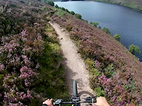
Photos of Ballater Mountain Bike
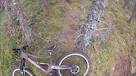
Videos of Ballater Mountain Bike
3:33 |
4 |
Mar 15, 2026

3:33 |
5 |
Mar 15, 2026
trail: Heartbreak Ridge
2:13 |
53 |
Oct 24, 2025
trail: Around the Head
0:52 |
55 |
Aug 11, 2020
trail: Tight around the loch
0:57 |
97 |
Aug 11, 2020
trail: Chocolate Orange
3:47 |
189 |
Apr 15, 2019

trail: Chocolate Orange
0:11 |
110 |
Sep 24, 2016
youtuber
![WOW what a trail! | Heartbreak Ridge Scotland]()
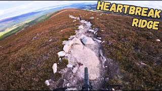
trail: Heartbreak Ridge
8:35 |
241 |
Oct 5, 2025 , Ballater
Recent Trail Reports
| status | trail | date | condition | info | user |
|---|---|---|---|---|---|
| Short One | Jun 18, 2026 @ 9:43am (Europe/Isle_of_Man) 16 hours | Ideal | weridemtbskillscoaching | ||
| Heartbreak Ridge | Jun 18, 2026 @ 9:43am (Europe/Isle_of_Man) 16 hours | Ideal | weridemtbskillscoaching | ||
| Trail | Jun 18, 2026 @ 9:43am (Europe/Isle_of_Man) 16 hours | Ideal | weridemtbskillscoaching | ||
| Gravel Road | Jun 18, 2026 @ 9:43am (Europe/Isle_of_Man) 16 hours | Ideal | weridemtbskillscoaching | ||
| Mastermind | May 29, 2026 @ 11:53am (Europe/Isle_of_Man) May 29, 2026 | Dry | Faroon | ||
| LandDrover Track | May 29, 2026 @ 11:53am (Europe/Isle_of_Man) May 29, 2026 | Dry | Faroon | ||
| Cambus O'May Bridge | May 21, 2026 @ 1:41pm (Europe/London) May 21, 2026 | Ideal | trailmax69 | ||
| Loamer | Mar 15, 2026 @ 1:13pm (Europe/London) Mar 15, 2026 | Unknown | IanDunk50 | ||
| Kate Moss | Mar 8, 2026 @ 5:10pm (Europe/London) Mar 8, 2026 | Unknown | howler986 | ||
| Storm | Nov 13, 2025 @ 10:02am (Europe/London) Nov 13, 2025 | Wet | chombo |
Activity Feed
| username | action | type | title | date |
|---|---|---|---|---|
| weridemtbskillscoaching | add | report | activity #97246548 | Jun 18, 2026 @ 6:04am 12 hours |
| weridemtbskillscoaching | add | report | activity #97246547 and 2 more | Jun 18, 2026 @ 6:04am 12 hours |
| Jezjez | wishlist | trail | activity #97165435 | Jun 16, 2026 @ 11:43pm 2 days |
| Kistler | wishlist | route | activity #97096288 | Jun 16, 2026 @ 2:59am 3 days |
| PinGlasgow | comment | trail | activity #97064499 | Jun 15, 2026 @ 2:05pm Jun 15, 2026 |
Recent Comments
| username | type | title | comment | date |
|---|---|---|---|---|
| trail | Amazing trail, running well at the moment. | Jun 15, 2026 @ 2:05pm Jun 15, 2026 | ||
| trail | This trail is known by other names on other... | Apr 28, 2026 @ 3:32pm Apr 28, 2026 | ||
| report | Tom , New trail should b listed on my bio page... | Mar 21, 2026 @ 2:35am Mar 21, 2026 | ||
| report | Noted! I only asked as I’ve come across logs... | Mar 20, 2026 @ 8:14am Mar 20, 2026 | ||
| report | Loamer isn’t the trail , it’s a new build... | Mar 14, 2026 @ 3:54am Mar 14, 2026 |
Local Badges
-

Epic Ride Climb 2k94 awarded -

Climbing 10k Badge62 awarded -

Climbing 100k Badge1 awarded -

Epic Ride Descent 2k95 awarded -

Descent 10k Badge63 awarded -

Descent 100k Badge1 awarded
Activity Type Stats
| activitytype | trails | distance | descent | descent distance | total vertical | rating | global rank | state rank | photos | reports | routes | ridelogs |
|---|---|---|---|---|---|---|---|---|---|---|---|---|
| Mountain Bike | 108 | 151 miles | 28,330 ft | 76 miles | 3,228 ft | #887 | #36 | 205 | 622 | 11 | 9,177 | |
| E-Bike | 106 | 149 miles | 28,264 ft | 75 miles | 3,228 ft | #176 | #18 | 13 | 581 | 6 | 2,291 | |
| Horse | 19 | 32 miles | 3,950 ft | 16 miles | 1,663 ft | #316 | #18 | 92 | ||||
| Hike | 101 | 148 miles | 26,335 ft | 73 miles | 3,228 ft | #839 | #25 | 1 | 572 | 1,134 | ||
| Trail Running | 101 | 148 miles | 26,335 ft | 73 miles | 3,228 ft | #718 | #26 | 572 | 691 |
Frequently Asked Questions About Ballater
▼
What are the best places to ride in Ballater?
Ballater has 1 areas to explore for mountain biking. The top rated areas are:
▼
What are the highest rated mountain biking trails in Ballater?
The highest rated mountain biking trails in Ballater are:
- Heartbreak Ridge (4.5/5)
- Storm (4.5/5)
- Mastermind (4.3/5)
- Streak of Lightening (4.1/5)
- Kate Moss (4.1/5)
▼
What is the best time of the year to ride in Ballater?
Based on ride log data, the most popular months to ride in Ballater are:
- July (80 activities)
- September (79 activities)
- August (70 activities)
▼
Where can I park to ride in Ballater?
There are 7 parking locations listed in Ballater. The most popular parking spots are: View all parking and trailhead locations on the map to plan your visit.
Activities
Trails
Points of Interest
- ballater activity log | embed map of Ballater mountain bike trails | ballater mountain biking points of interest polygons
Downloading of trail gps tracks in kml & gpx formats is enabled for Ballater.
You must login to download files.