close
-
Layers w
- Weather Layers
- Pro
- Pro
- Pro
- Pro
- Pro
- Pro
- More Layers
- Pro
- Pro
- Pro
- Pro
-
Upgrade to

3D
Trail Conditions
- Unknown
- Snow Groomed
- Snow Packed
- Snow Covered
- Snow Cover Partial
- Freeze/thaw Cycle
- Icy
- Prevalent Mud
- Wet
- Variable
- Ideal
- Dry
- Very Dry
Trail Flow (Ridden Direction)
Trailforks scans users ridelogs to determine the most popular direction each trail is ridden. A good flowing trail network will have most trails flowing in a single direction according to their intension.
The colour categories are based on what percentage of riders are riding a trail in its intended direction.
The colour categories are based on what percentage of riders are riding a trail in its intended direction.
- > 96%
- > 90%
- > 80%
- > 70%
- > 50%
- < 50%
- bi-directional trail
- no data
Trail Last Ridden
Trailforks scans ridelogs to determine the last time a trail was ridden.
- < 2 days
- < 1 week
- < 2 weeks
- < 1 month
- < 6 months
- > 6 months
Trail Ridden Direction
The intended direction a trail should be ridden.
- Downhill Only
- Downhill Primary
- Both Directions
- Uphill Primary
- Uphill Only
- One Direction
Contribute Details
Colors indicate trail is missing specified detail.
- Description
- Photos
- Description & Photos
- Videos
Trail Popularity ?
Trailforks scans ridelogs to determine which trails are ridden the most in the last 9 months.
Trails are compared with nearby trails in the same city region with a possible 25 colour shades.
Think of this as a heatmap, more rides = more kinetic energy = warmer colors.
- most popular
- popular
- less popular
- not popular
ATV/ORV/OHV Filter
Max Vehicle Width
inches
US Cell Coverage
Legend

Radar Time
Activity Recordings
Trailforks uses anonymized public activity data.
?
Activity Recordings
Trailforks uses anonymized public activity data.
?
Personal Heatmap
▶
Activity Types
all
/
none
▶
Options
2
Date range
month
–
Winter Trails
Warning
A routing network for winter maps does not exist. Selecting trails using the winter trails layer has been disabled.
Missing Trails
Most Popular
Least Popular
Trails are colored based on popularity. The more popular a trail is, the more red. Less popular trails trend towards green.
Jump Magnitude Heatmap
Heatmap of where riders jump on trails. Zoom in to see individual jumps, click circles to view jump details.
BC Backroad Status
![map legend]()
Service Road Atlas is a free to use, community-driven service for viewing and creating reports on the numerous back-country service roads around B.C. and Alberta.

Slope Aspect
Direction the slope faces
Trails Deemphasized
Trails are shown in grey.
Only show trails with no bike usage.
Suggested Layers
Based on selected activity type
Save the current map location and zoom level as your default home location whenever this page is loaded.
Save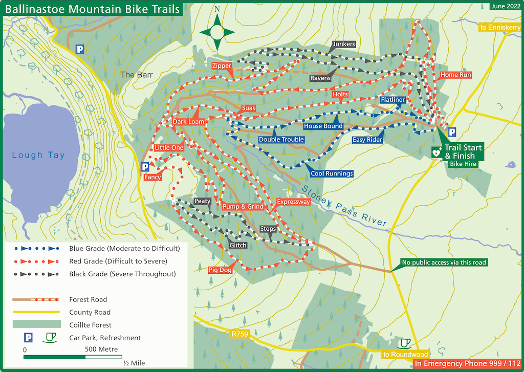

Activities Click to view
- Mountain Bike
31 trails
- E-Bike
21 trails
- Hike
21 trails
- Trail Running
21 trails
Region Details
- 7
- 10
- 9
- 5
Region Status
Caution as of May 11, 2026Stats
- Avg Trail Rating
- Trails (view details)
- 34
- Trails Mountain Bike
- 31
- Trails E-Bike
- 21
- Trails Hike
- 21
- Trails Trail Running
- 21
- Total Distance
- 30 miles
- Total Descent
- 6,674 ft
- Total Vertical
- 1,557 ft
- Highest Trailhead
- 2,243 ft
- Reports
- 701
- Photos
- 56
- Ridden Counter
- 11,818
Popular Ballinastoe Mountain Biking Trails
• 90 ★ 4.9 • 4,616 ft • 3 ft • 605 •
Highly rated popular red difficulty singletrack. This mountain bike primary trail can be used downhill only and has a moderate overall physical rating with a 3 ft green climb. It features berm, jump, rock garden and roller coaster. Trail visibility is always easy to follow. On average it takes 4 minutes to complete this trail.
• 95 ★ 4.8 • 1,873 ft • 0 ft • 538 •
Popular blue difficulty singletrack. This mountain bike primary trail can be used downhill only. On average it takes 2 minutes to complete this trail.
• 75 ★ 4.8 • 3,245 ft • 0 ft • 524 •
Time to get back to the start. This blue flowy trail will make you want to go up and repeat again. Last update by TrailBreaker trail builders (dec 2021) modified 2nd half to make fun as hell, huge berms that allow you to carry plenty of...
• 65 ★ 4.9 • 4,659 ft • 19 ft • 508 •
Highly rated moderately popular red difficulty singletrack. This mountain bike primary trail can be used downhill only. On average it takes 5 minutes to complete this trail.
• 85 ★ 4.0 • 1,739 ft • 45 ft • 494 •
Popular blue difficulty singletrack. This mountain bike primary trail can be used downhill only. It features jump and pump track. Trail visibility is always easy to follow. On average it takes 1 minutes to complete this trail.
• 65 ★ 4.4 • 3,106 ft • 5 ft • 454 •
Highly rated moderately popular blue difficulty singletrack. This mountain bike primary trail can be used downhill primary and has a easy overall physical rating with a 5 ft green climb. It features berm and rock garden. On average it takes 4 minutes to complete this trail.
• 95 ★ 5.0 • 1 mile • 4 ft • 394 •
Popular red difficulty machine groomed. This mountain bike primary trail can be used downhill only and has a hard overall physical rating with a 4 ft blue climb. It features berm, jump, pump track and roller coaster. Adaptive MTB rating: amtb blue. Trail visibility is always easy to follow. On average it takes 6 minutes to complete this trail.
Ballinastoe Mountain Bike Routes
★ 4.0 • 8 miles • 1,036 ft • 16 • Loop •
Easy to follow mtb loop in Ballinastoe woods
★ 5.0 • 30 miles • 4,792 ft • 20 • Loop • Race •
There are two types of format, Classic and Mash Up. Classic means the stages need to be ridden in order...
★ 5.0 • 16 miles • 3,781 ft • 0 • Shuttled • Race •
Route of the 2014 Djouce Gravity Enduro
9 miles • 1,170 ft • 9 • Loop • Race •
Race route for the Biking Blitz 2022: Ballinastoe. Juniors and Novice one lap, Expert 2 laps.
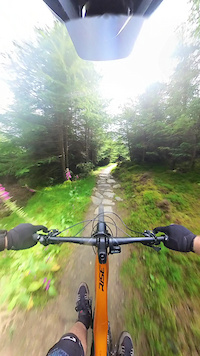
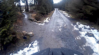
Photos of Ballinastoe Mountain Bike
Videos of Ballinastoe Mountain Bike
trail: Expressway
0:16 |
76 |
Jul 26, 2024
trail: House Bound
6:41 |
428 |
Mar 11, 2016
trail: Expressway
3:27 |
101 |
Mar 8, 2016
trail: Bump & Grind
7:18 |
482 |
Mar 1, 2016
3:18 |
145 |
Sep 2, 2014
0:18 |
152 |
Aug 18, 2014

2:04 |
380 |
Jun 9, 2014
2:21 |
148 |
May 28, 2014
Recent Trail Reports
| status | trail | date | condition | info | user |
|---|---|---|---|---|---|
| parking to hiking path | May 11, 2026 @ 9:39pm (Europe/Dublin) May 11, 2026 | Very Dry | elyari TRAILFORKS | ||
| connector between hiking trails | May 11, 2026 @ 9:39pm (Europe/Dublin) May 11, 2026 | Very Dry | elyari TRAILFORKS | ||
| Zipper | May 11, 2026 @ 9:39pm (Europe/Dublin) May 11, 2026 | Very Dry | elyari TRAILFORKS | ||
| War Hill Summit | May 11, 2026 @ 9:39pm (Europe/Dublin) May 11, 2026 | Very Dry | elyari TRAILFORKS | ||
| Junkers | May 11, 2026 @ 9:39pm (Europe/Dublin) May 11, 2026 | Very Dry | elyari TRAILFORKS | ||
| Indriya (start section) | May 11, 2026 @ 9:39pm (Europe/Dublin) May 11, 2026 | Very Dry | elyari TRAILFORKS | ||
| House Bound | May 11, 2026 @ 9:39pm (Europe/Dublin) May 11, 2026 | Very Dry | elyari TRAILFORKS | ||
| Home Run | May 11, 2026 @ 9:39pm (Europe/Dublin) May 11, 2026 | Very Dry | elyari TRAILFORKS | ||
| Glitch | May 11, 2026 @ 9:39pm (Europe/Dublin) May 11, 2026 | Very Dry | elyari TRAILFORKS | ||
| Flatliner | May 11, 2026 @ 9:39pm (Europe/Dublin) May 11, 2026 | Very Dry | elyari TRAILFORKS |
Activity Feed
| username | action | type | title | date |
|---|---|---|---|---|
| OliverLxBg3A | ridden | trail | activity #97009017 | Jun 14, 2026 @ 3:29pm Jun 14, 2026 |
| BrendonSmythb0w | wishlist | route | activity #96374324 | Jun 6, 2026 @ 8:32am Jun 6, 2026 |
| BrendonSmythb0w | wishlist | region | activity #96370124 | Jun 6, 2026 @ 7:49am Jun 6, 2026 |
| elyari | checkin | route | activity #94849852 | May 16, 2026 @ 1:55pm May 16, 2026 |
| elyari | vote | route | activity #94849830 | May 16, 2026 @ 1:55pm May 16, 2026 |
Recent Comments
| username | type | title | comment | date |
|---|---|---|---|---|
| trail | Gnnnnnaaarrr! | Jul 11, 2023 @ 12:32pm Jul 11, 2023 | ||
| trail | So much fun! | Jul 11, 2023 @ 12:31pm Jul 11, 2023 | ||
| trail | thanks! updated! | Jul 24, 2020 @ 3:48am Jul 24, 2020 | ||
| trail | Cool runnings is the official name | Jul 19, 2020 @ 5:32am Jul 19, 2020 | ||
| trail | This trail is called coal minet | Aug 18, 2019 @ 6:53am Aug 18, 2019 |
Nearby Areas
| name | distance | ||||
|---|---|---|---|---|---|
| Lough Dan | 2 | 5 | 2.7 km | ||
| Wicklow | 2.9 km | ||||
| Djouce Woods | 11 | 3.1 km | |||
| Crone | 1 | 5 | 2 | 4 km | |
| Downs Hill | 10 | 1 | 4.8 km |
Local Badges
-

Completionist0 awarded
Activity Type Stats
| activitytype | trails | distance | descent | descent distance | total vertical | rating | global rank | state rank | photos | reports | routes | ridelogs |
|---|---|---|---|---|---|---|---|---|---|---|---|---|
| Mountain Bike | 31 | 25 miles | 5,951 ft | 15 miles | 1,220 ft | #832 | #3 | 52 | 700 | 9 | 6,832 | |
| E-Bike | 21 | 17 miles | 4,547 ft | 11 miles | 1,188 ft | #885 | #8 | 658 | 7 | 1,248 | ||
| Hike | 21 | 20 miles | 2,815 ft | 9 miles | 1,558 ft | #1,521 | #11 | 651 | 212 | |||
| Trail Running | 21 | 20 miles | 2,815 ft | 9 miles | 1,558 ft | #971 | #12 | 651 | 149 |
Frequently Asked Questions About Ballinastoe
▼
What are the highest rated mountain biking trails in Ballinastoe?
The highest rated mountain biking trails in Ballinastoe are:
- Expressway (4.5/5)
- Bump & Grind (4.4/5)
- Holts (4.3/5)
- Junkers (4.3/5)
- Flatliner (4.3/5)
▼
What is the best time of the year to ride in Ballinastoe?
Based on ride log data, the most popular months to ride in Ballinastoe are:
- July (52 activities)
- August (42 activities)
- September (35 activities)
▼
Where can I park to ride in Ballinastoe?
There are 5 parking locations listed in Ballinastoe. The most popular parking spots are: View all parking and trailhead locations on the map to plan your visit.
▼
What is the longest trail in Ballinastoe?
The longest trail in Ballinastoe is Junkers at 1.3 miles. View all trails sorted by distance.
Activities
Trails
Points of Interest
- By brenthillier
 NSMBA TRAILFORKS & contributors
 - Admins: apply
- #4905 - 29,276 views
- ballinastoe activity log | embed map of Ballinastoe mountain bike trails | ballinastoe mountain biking points of interest
Downloading of trail gps tracks in kml & gpx formats is enabled for Ballinastoe.
You must login to download files.